
DESIGN AND IMPLEMENTATION OF THE VALID TIME FOR
SPATIO-TEMPORAL DATABASES
Jugurta Lisboa Filho, Gustavo Breder Sampaio, Evaldo de Oliveira da Silva and Alexandre Gazola
Universidade Federal de Viçosa, Departamento de Informática, 36570-000, Viçosa, MG, Brazil
Keywords: Geographic database, GIS, Spatio-Temporal Data Modeling.
Abstract: Three different types of time are identified in the literature on Temporal Database Management Systems:
valid time, transaction time and existence time. This paper describes the design of the valid time for Spatio-
Temporal Databases in Geographic Information Systems, based on the UML-GeoFrame conceptual data
model. It is also presented two translation rules of the valid time from the conceptual to logical level, im-
plemented for the TerraLib Spatial Components Library.
1 INTRODUCTION
A number of government and business organizations
need to handle data that vary simultaneously with
time and space, which is most of the time carried out
using Geographical Information Systems (GIS). In
some government agencies as well as the depart-
ments linked to mapping and monitoring of envi-
ronmental risks, urban planning, residential and in-
dustrial zoning, of epidemic control, among others,
the time factor is a fundamental element.
These agencies use GIS to execute operations of
spatial analysis and make decisions based on results
of these analyses, however, a great number of times
the temporal aspect of the used information is not
appropriately considered. This comes from the great
difficulty GIS designers and users find when design-
ing a spatio-temporal database and developing ap-
plications that allow the representation of phenom-
ena that vary with time and space.
There are several conceptual data models for
geographical database design, some with support for
modeling temporal aspects. MADS (Parent. et al.,
1999), Geo-ER (Tryfona. et al., 2003) and Percep-
tory (Bédard, 1999) are examples of these models
and tools. These conceptual data models seek to
consider all the possible variations of spatio-
temporal data, making them highly complex models
and of little practical use for most geographical da-
tabase designers.
Three different types of time are identified in the
literature on Temporal Database Management Sys-
tems: valid time
- instant or interval of time in which
a phenomenon is valid; transaction time
- time in
which the datum is inserted into or eliminated from a
given database; and existence time
- time in which
the object really exists in the reality.
The conceptual data model UML-GeoFrame ex-
tends the UML class diagram to geographical data-
base design (Lisboa Filho and Iochpe, 1999).
Rocha et al. (2001) proposed an extension to the
UML-GeoFrame model for modeling temporal as-
pects that comprises these three types of time. How-
ever, as for the other models previously mentioned,
the enormous possibility of combinations among the
geographic phenomenon properties regarding tem-
poral features, become the understanding, modeling
and implementation of all these types very complex.
This article presents a simplified approach for
modeling and implementation of spatio-temporal
phenomena based on the valid time, using the UML-
GeoFrame conceptual data model. It also presents
the incorporation of these aspects into a CASE tool
called ArgoCASEGEO. This tool is capable of trans-
forming conceptual spatio-temporal data schemas
into logical data schemas for the main data models
of commercial GIS (eg.: Shape File Format, Oracle
Spatial) and also for the data model of TerraLib spa-
tial library (Vinhas and Ferreira, 2005).
569
Lisboa Filho J., Breder Sampaio G., de Oliveira da Silva E. and Gazola A. (2007).
DESIGN AND IMPLEMENTATION OF THE VALID TIME FOR SPATIO-TEMPORAL DATABASES.
In Proceedings of the Ninth International Conference on Enterprise Information Systems - ISAS, pages 569-573
DOI: 10.5220/0002386405690573
Copyright
c
SciTePress
2 THE COMCEPTUAL DATA
MODEL UML-GEOFRAME
The conceptual modeling of geographical database
based on the Unified Modeling Language (UML)
and on the GeoFrame framework (Lisboa Filho and
Iochpe, 1999) generates an easy-to-understand data-
base schema, improving communication among de-
signers and/or users.
GeoFrame is a conceptual framework that pro-
vides a basic class diagram to assist the designer on
the first steps of the conceptual data modeling of a
new GIS application. The mutual use of UML class
diagram and GeoFrame allows the solution of most
requirements of GIS application modeling. A con-
ceptual schema of geographical data, based on the
UML-GeoFrame model includes, for instance, the
modeling of spatial aspects of the geographical in-
formation, in other words, the type of spatial repre-
sentation of each phenomenon, and the difference
between conventional objects and geographical ob-
jects/fields. The specification of these elements is
based on the stereotype concept, which is an UML
extension mechanism (Booch,, Jacobson and Rum-
baugh, 1998).
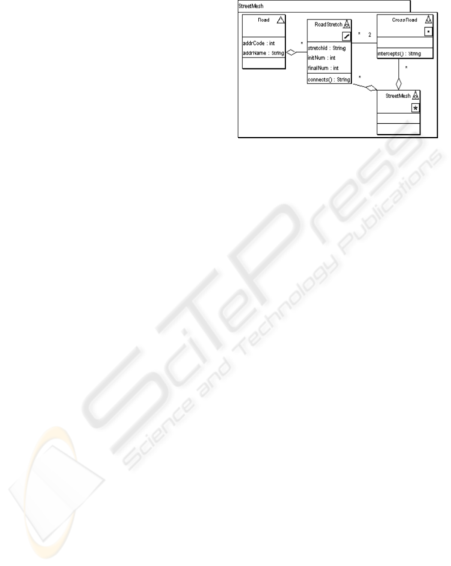
As example, Figure 1 illustrates an UML-
GeoFrame data schema, where the UML package
represents a theme relative to the real world that is
being modeled and all of them concern the same
specific geographical area (eg.: a street). The theme
Street Mesch comprises four classes of an urban
cadastre application. In the theme some classes are
geographicals objects, wich are modeled with stereo-
type of object view (<3>).
The spatial representation of classes of geo-
graphical phenomena perceived in object view can
be of a point <>, line <>, polygon <> or com-
plex <>, in this case when it is formed by more
than one spatial object. The geographical fields can,
in turn, be represented by one of the six types of
representation of attributes varying in space, de-
scribed by Goodchild (1992), which are: Irregularly
sampled points <8>, Adjacent polygons <1>, Con-
tour lines <;>, Triangular irregular network, or
TIN, <:>, Cell grids <<> and/or Regularly sam-
pled points <9>. The existence of multiple repre-
sentations is modeled through the combination of
two or more stereotypes in a same class. For exam-
ple, a class Municipality can have two abstraction
forms of its spatial component (a point or an area),
which is specified by the pair of stereotypes <>.
Figure 1: Example of UML-GeoFrame schema.
3 THE GEOFRAME-T PROPOSAL
GeoFrame-T is a GeoFrame temporal extension for
modeling conventional, spatial, temporal and spatio-
temporal objects (Rocha et. al., 2001) based on the
TUML concept (Svinterikou, 1997). One of the main
GeoFrame-T characteristics is to include the aspect
time also for attributes and relationships.
The representation of temporal aspects in
GeoFrame-T is carried out by the TemporalObject
class, where there is an association of aggregation
with the class TimeObject, which can have or not
instances of the class TemporalMetadata associated
with it. The TemporalMetadata class has attributes
that describe the concepts of objects existing in the
TimeObject class. These attributes qualify informa-
tion on the reference systems based on time values
such as the Greenwich meridian and local coordinate
references. Other TemporalMetadata class attributes
are granularity and calendar, which describe the time
(month, year, day, second, etc.), and the type of cal-
endar considered for the time. Rocha et al. (2001),
defined the TimeObject class as a generalization of
Static and TemporalType classes, which is special-
ized in ValidTime, TransactionTime and Bitemporal.
The Static class represents objects with no tem-
poral variation associated. Through the class Trans-
actionTime, it is possible conceptually to model ob-
jects that should have their historical information
retained, whose time variation is linear, considering
the time in which the information was entered into
the database. The class ValidTime enables the tem-
poral modeling of a spatial object, whose time is
considered in accordance with the modeled reality,
being likely to occur linear or ramified variation.
Finally, the Bitemporal class can model spatial ob-
jects, considering both the recording and the valid
time, inheriting thus characteristics of Transaction-
Time and ValidTime classes.
ICEIS 2007 - International Conference on Enterprise Information Systems
570

Following the same fundamentals of
GeoFrame modeling, GeoFrame-T uses stereotypes
to facilitate the modeling of objects and geographi-
cal phenomena. In the GeoFrame-T model, the Tem-
poralObject class is considered as a time structure
possible of being represented by the modeled
classes. GeoFrame-T enables us to model conceptu-
ally the relationships between geographical phenom-
ena and their temporal characteristics. These rela-
tionships are represented by the Relationship class.
All the static and non-spatial relationships existent
among the modeled classes are considered instances
of the Relationship class.
4 MODELING THE VALID TIME
The descriptive, temporal and spatial dimensions are
orthogonal. Temporal properties can be defined by
the three categories of geo-spatial data: conventional
objects, geographical phenomena perceived in field
view and geographical phenomena perceived in ob-
ject view. A model that considers the three types of
time (valid, transaction and existence) for both
classes and attributes and relationships provides the
designer with great power of expression. However,
the great number of possible combinations also
makes the model difficult to learn and understand,
eventually compromising the implementation of
applications needed for handling spatio-temporal
data.
Experience has showed that in most GIS applica-
tions only the valid time of the geographical phe-
nomena has been considered, since this is the most
significant piece of information in most queries in-
volving temporal data. This article shows, in this
way, how design aspects spatio-temporal based on
the valid time, using UML-GeoFrame model, in
which only the valid time is considered.
Valid time is the time instant or time interval
when an object of the real-world is considered valid.
For example, the strike against the World Trade
Center took place on September 11, 2001, in turn,
the Gulf War occurred in the period between August
1990 and February 1991. Hence, another important
factor is the granularity of temporal information.
The UML-GeoFrame model considers three types of
time granularity: Date, Time and Timestamp. Speci-
fying the granularity of a temporal attribute is the
same as defining the domain of a descriptive attrib-
ute value (e.g. Char or Boolean). Finally, two types
of temporal classes are discriminated: Instant Class
and Interval Class.
If a class is modeled as being of Instant type
(stereotype <
>), it means that its objects are only
valid at a particular point in time. In this case, the
object does not evolve, since its validity is con-
densed into an instant. It is the case of a road acci-
dent representation, in which is essential to associate
an instant of time with the object.
If the class is of the Interval type (stereotype
<>), it means that its objects are valid in a period
of time, i.e., between an initial and a final temporal
value. These valid intervals do not necessarily have
the same size. In addition, the object evolution is
maintained, because its attributes can vary in the
period corresponding to its valid interval.
If a class is temporal of Interval type, it indicates
that every change in any object attribute will gener-
ate a new version of the object, and the old one will
not be lost.
Each temporal class must have its granularity
specified. The option Date is the default option and
indicates that a value of the date type has to be
stored. The option Time indicates the need for stor-
age of an complete hour value. The option Time-
stamp indicates that a pair (date, hour) must be
stored into the database. Each object (or object ver-
sion) is associated with a piece of temporal informa-
tion, characterized by a stereotype, along with the
chosen granularity.
Besides allowing the modeling of temporal
classes, the UML-GeoFrame model enables the rep-
resentation of temporal associations, which is identi-
fied by the stereotype <<time>>. The validity of an
association can be defined as the intersection of ob-
ject’s valid periods of classes involved in this asso-
ciation. This is because it is impossible for a rela-
tionship to exist in an instant of time in which a re-
lated object is not valid. Thus, considering t as this
period of intersection, it follows that:
Temporal Association - its validity must be con-
tained into the interval t, i.e., the association must be
valid at the most for the period of time in which both
objects coexist in time;
Non-temporal Association - its validity is same
as interval t. In this case, the interpretation is the
same given to conventional relationships, where the
association is valid while the objects coexist in time.
Some association examples involving classes of spa-
tio-temporal phenomena can be presented, when two
classes of geographical phenomena are perceived in
object view, where both were modeled as temporal
classes of the Interval type.
For example, an association between the classes
Country and Epidemic, where the class Country
could have information of name, population and
DESIGN AND IMPLEMENTATION OF THE VALID TIME FOR SPATIO-TEMPORAL DATABASES
571
GDP (Gross Domestic Product). These attributes
could vary in time, generating different versions of
an object from the Country class. The Epidemic
class describes epidemics that could occur in these
countries, through the temporality. This temporality
is important because of the need for observing its
evolution in time, as well as possible periods of out-
breaking and eradication. This relationship is de-
fined as temporal (<<time>>), indicating that a same
type of epidemics could occur in more than a period
in the same country.
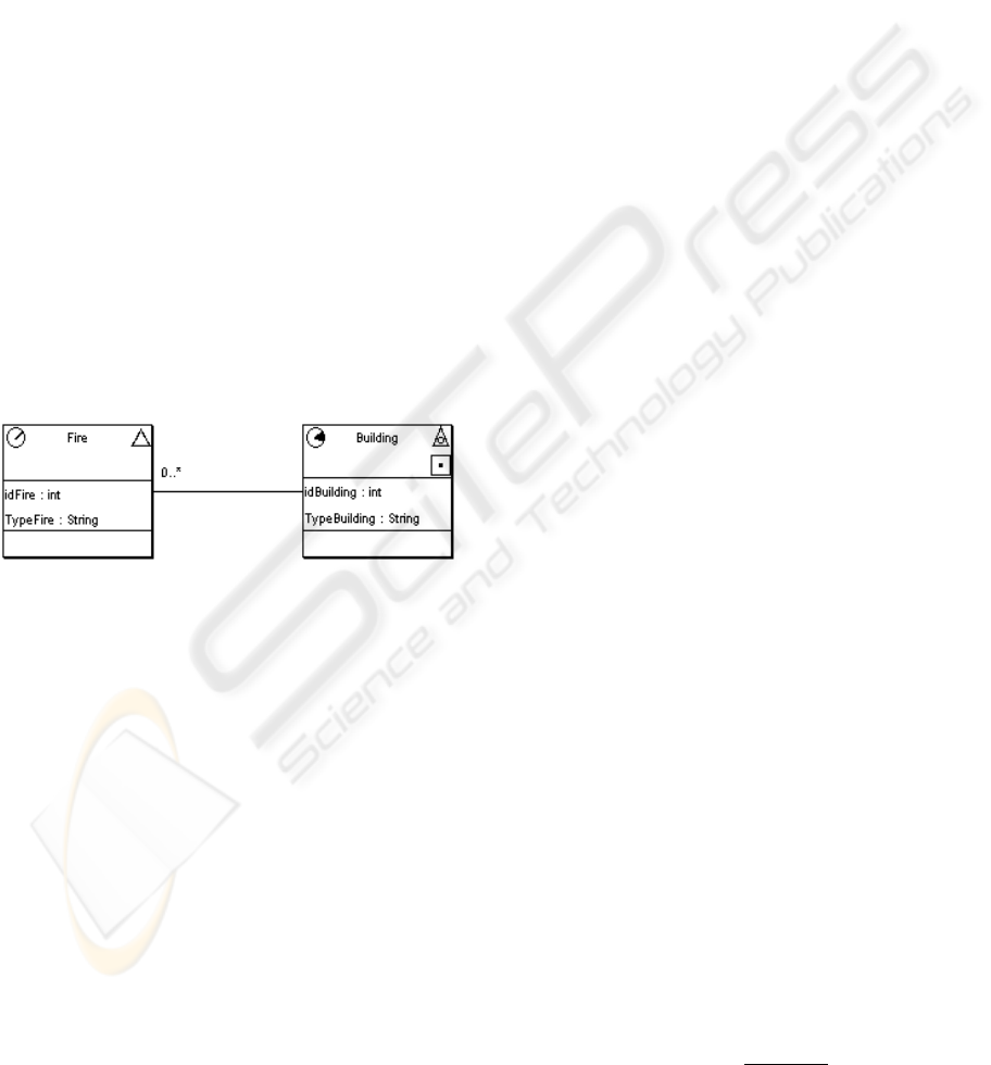
The association in Figure 2 illustrates the Fire
and Building classes, the former being of non-geo-
graphical object type, but temporal of Instant type.
The Building class describes the existent buildings
and their use, such as museums, hospitals or schools.
The Building class is temporal of Interval type,
which means that a building has an existence period
characterized by the time interval relative to each
type of use. The association (non-temporal) between
these two temporal classes will make each Fire oc-
currence be associated with the most recent version
of a Building object. Therefore, in case one wants to
register the historical occurrence of a fire, it will not
be possible to associate it with the correct version of
the Building object.
Figure 2: Non-temporal association with temporal classes.
5 TEMPORAL MODELING IN
THE ARGOCASEGEO TOOL
ArgoCASEGEO is a CASE tool built to support
modeling and design of geographical databases with
the UML-GeoFrame model (Lisboa Filho et. al.,
2004). To support the modeling of temporal classes,
the modules Graphic Design, Data Dictionary and
Automatic Generation were changed.
The ArgoCASEGEO Graphic Module was ex-
tended to support the temporal builders modeling, in
other words, to enable the specification of the stereo-
types Instant <> and Interval <>, as well as al-
lowing the designer to specify a type of granularity
for each temporal class.
A conceptual data schema drawn up using the
ArgoCASEGEO tool is stored in a XMI file (XML
Metadata Interchange), which is automatically cre-
ated in the Data Dictionary Module. New tags were
added to the XMI schema to store the definitions of
temporal characteristics of a class.
The Automatic Generation Module (AGM) is re-
sponsible for the application of rules that transform a
conceptual data schema into a logical-spatial data
schema. As there is still no standard model adopted
by the available GIS software, the ArgoCASEGEO
tool has an AGM for some commercial systems and
also an AGM for the Open Source Library - Terra-
Lib (Vinhas, 2005).
Aiming at validating the temporal extension pro-
posed to the UML-GeoFrame model, in this work
the AGM-TerraLib was extended to enable the
specification of logical data schema. Thus, starting
from the XMI file, the AGM-TerraLib transforms an
UML-GeoFrame conceptual schema into a TerraLib
logical schema. In the following section the trans-
formation rules implemented are described.
6 RULES FOR TEMPORAL
ASPECTS TRANSFORMATION
The transformation rules are defined using the rela-
tional model as basis, following the TerraLib
schema. Therefore, a primary key must be specified
in each class in order to carry out the transformation
correctly.
6.1 Rule 1: Transformation of
Temporal Classes
The attributes defined for a class generate attributes
in a corresponding relation. A temporal attribute
with the domain defined in accordance with the
specified granularity is added to temporal classes of
Instant type.
For temporal classes of Interval type, having a
primary key (PK) and a set of attributes {att}, a rela-
tion with PK is created. The foreign keys, if existing,
are also added to this relation. In addition, a second
relation is created to store the versions of its objects.
To guarantee the integrity, a relationship 1..N be-
tween the first relation and the version relation is
also created.
The primary key of the version relation is PK,
plus a temporal attribute. Thus, the version relation
will have the following schema:
RELATION_VERSION = (PK,begin,end,{att})
ICEIS 2007 - International Conference on Enterprise Information Systems
572
6.2 Rule 2: Transformation of
Temporal Associations
Given a temporal association, regardless of its mul-
tiplicity, a new relation is created with the primary
keys of the involved classes. This new relation is
required for storing the validity period of the asso-
ciation. With this objective, two temporal attributes
are created to indicate the beginning and the end of
the association validity.
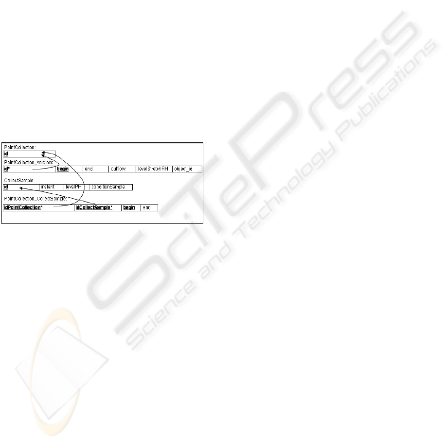
One wants to create an association between them
in order that it is possible to store data on river sam-
ple collection for each collection point, with sam-
pling being done at different instants.
The first alternative is to model a non-temporal
association representing that each collection point
has several samples.
Another alternative is to model a temporal asso-
ciation, indicating that each collection point has only
one sample at a same instant in time. In this case the
relations schemas shown in Figure 3 will be gener-
ated.
Figure 3: Schemas generated from a temporal association.
The designer can take the second option to express
better the association. However, there is a question
to be discussed; the attributes begin and end of the
relation PointCollection_CollectionSample are re-
dundant, since the only value that they can take is
the valid instant of the sample collection. This re-
striction must be guaranteed by the application. It
also must not allow that a point has more than one
sample at a same instant, because this is incompati-
ble with what was specified.
7 CONCLUSIONS
In this article we presented a proposal to simplify the
conceptual modeling of temporal aspects in spatio-
temporal database. The concepts were presented as
an extension to the UML-GeoFrame model, however
they can be adapted to any conceptual data model.
Modeling the temporal aspect of an application
has not been a trivial task, probably due to the com-
plexity of the existent temporal models in the litera-
ture. The completeness of the temporal aspects is
actually necessary in a very restricted set of prob-
lems, for the great majority of temporal applications,
modeling valid time of real-world objects is enough.
Some examples of modeling of classes and tem-
poral relationships were presented and the Argo-
CASEGEO tool support for modeling of spatio-
temporal aspects was described.
At the present, only the Automatic Generation
Module for TerraLib library is dealing with temporal
aspects. An AGM for the Oracle-Spatial system is
being implemented and the temporal extension will
be drawn up for AGM-ShapeFiles.
ACKNOWLEDGEMENTS
This work was partially financed by the Foundation
for Research Support of the Minas Gerais - Fapemig.
REFERENCES
Bédard, Y., 1999. Visual modelling of spatial databases
towards spatial extensions and UML. Geomatica,
v.53, n.2.
Booch, G., Jacobson, I. and Rumbaugh, J., 1998. The Uni-
fied Modeling Language User Guide. Addison-
Wesley.
Goodchild, M. F., 1992. Geographical data modeling.
Computers & Geosciences. 18(4).
Lisboa Filho, J. and Iochpe, C., 1999. Specifying analysis
patterns for geographic databases on the basis of a
conceptual framework. In Proc. of 7
th
ACM Sympo-
sium on Advances in GIS, Kansas City.
Lisboa Filho, J. Sodré, V. F., Daltio, J. Fidelis, M. R. and
Vilela, V., 2004. A CASE tool for geographic data-
base design supporting analysis patterns. In Workshop
on conceptual modeling for GIS, Shanghai. Springer-
Verlag LNCS 3289.
Parent, C, Spaccapietra, S. and Zimányi, E., 1999. Spatio-
temporal conceptual models: data structures + space +
time. In Proc.7th ACM GIS, Kansas City.
Rocha, L. V., Edelweiss, N. and Iochpe, C., 2001.
GeoFrame-T: A temporal conceptual framework for
data modeling. In Proc.9
th
ACM GIS, Atlanta.
Svinterikou, M. and Theodoulidis, B. 1997. The temporal
Unified Modeling Language (TUML). Dep. of Compu-
tation, UMIST, UK, (TR97-1).
Tryfona, N., Price, R. and Jensen, C. S., 2003. Spatiotem-
poral conceptual modeling. In Spatiotemporal Data-
bases: the Chorochronos approach, Springer-Verlag.
Vinhas, L. and Ferreira, K. R., 2005. Descrição da
TerraLib. In Casanova, M. A. et al. Bancos de Dados
Geográficos, Curitiba: MundoGeo.
DESIGN AND IMPLEMENTATION OF THE VALID TIME FOR SPATIO-TEMPORAL DATABASES
573
