
BUSINESS INTELLIGENCE BASED ON A WI-FI REAL TIME
POSITIONING ENGINE
A Practical Application in a Major Retail Company
Vasco Vinhas, Pedro Mendes and Pedro Abreu
FEUP - Faculdade de Engenharia da Universidade do Porto, Rua Dr. Roberto Frias s/n, Porto, Portugal
DEI - Departamento de Engenharia Informática, Rua Dr. Roberto Frias s/n, Porto, Portugal
LIACC - Laboratório de Inteligência Artificial e Ciência de Computadores, Rua do Campo Alegre 823, Porto, Portugal
Keywords: Wi-Fi, Real-Time Tracking, Business Intelligence, Retail.
Abstract: Collecting relevant data to perform business intelligence on a real time basis has always been a crucial
objective for managers responsible for economic activities on large spaces. Following this emergent need,
the authors propose a platform to perform data gathering and analysis on the location of people and assets
by automatic means. The developed system is retail business oriented and has a fairly distributed
architecture. It couples the core elements of a real-time Wi-Fi based location system with a set of developed
functional views so to better explicit the information that one can observe for each tracked entity, the
undertaken path on the space, demographic concentration patterns. Tests were conducted on a real
production environment as a partnership outcome with a major player in the retail sector and the obtained
results were completely satisfactory having the managers confirmed the provided knowledge relevance.
1 INTRODUCTION
People and asset’s tracking and positioning data
collection – even if with the sole purpose of locating
those entities – on a given space, has always been a
need for those with management responsibilities,
regardless their economic sector. Up until thirty
years ago, the mechanisms to pursue such objective
were manifestly out of reach of the masses mainly
due to financial reasons. At that time, most systems
were part of military projects and made use of radar
technology to passively detect air or marine traffic
(LaFollette et al., 1991), although in this last case
the positioning was achieved through an active
procedure – the traceable water vehicle had to
intentionally transmit a radio signal with its latitude
and longitude encoded (Yu, 2005).
However the recent advances in several domains
such as computer technology, video capturing and
positioning sensors changed the previously
mentioned premises. Nowadays video surveillance
systems, with mid-end camera resolution are cost-
effective even in the context of small and medium
enterprises – SMEs – with the non minor advantage
of complete digital storage and processing. In spite
of a video feed does not provide data on the
positioning of entities, in the corresponding
camera’s scope, in way that such information can be
retrieved automatically. With the latest wireless
networks proliferation, other approaches emerged,
with the obvious advantage of automatically
providing clean data at a semantic level, displayable
and storable in a straightforward way. Among the
technologies that fit in this situation one shall refer
to: Bluetooth; Wi-Fi; RFID; GPS; amongst others.
Naturally, each of them encloses its strengths and
flaws. Some require the traceable items to have an
active behavior while others process them as passive
items. The coverable area and the error involved are
also important factors to be considered as well as the
required resources, such as power and equipment
density. Some of them remain unwavering with
layout changes while others require a full system
recalibration.
The research work proposed in this document
materializes itself on a system that takes advantage
of typical redundant Wi-Fi networks and is based on
a positioning engine built on top of these. The
system provides a visualization platform of such
data on a real time basis. The information can be
displayed through several perspectives, including
fully scalable concentration grids, clean positioning
11
Vinhas V., Abreu P. and Mendes P. (2009).
BUSINESS INTELLIGENCE BASED ON A WI-FI REAL TIME POSITIONING ENGINE - A Practical Application in a Major Retail Company.
In Proceedings of the 11th International Conference on Enterprise Information Systems - Databases and Information Systems Integration, pages 11-16
DOI: 10.5220/0001858000110016
Copyright
c
SciTePress

of the elements at hand or even a vision inference
assuming that the items to be tracked are associated
with people. This system was originally developed
for a corporate entity operating in the global retail
market, whose institutional designation is obfuscated
by commercial reasons. Following the same line of
reasoning all data provided; application’s
screenshots and shop floor layouts were based on
real production data and were obfuscated, without
compromising functionality and intelligibility.
2 STATE OF THE ART
Despite the advances in this field, leading to
noteworthy breakthroughs, some issues still remain
to be addressed. From these, one ought to point out
those concerning occlusion, which are classifiable in
three distinct categories: self-occlusion, where part
of the object to trace, typically articulated ones,
occludes another part; inter-object occlusion where
two traceable objects occlude each other; and
occlusion by the background scene where the
physical space’s properties propitiate a camouflage
of the object to track. For the inter-object occlusion
research works like (MacCormick and Blake, 2000)
(Elgammal et al., 2000) exploit the a priori
knowledge of the object’s position and attempt to
predict possible occlusions and solve them
smoothly.
Considering other domain issues, the hurdles that
arise when tracking entities with non-linear
movements must be addressed as this point
constitutes one of the major problems in tracking
persons in non controllable environments. A
pragmatic approach to this situation could point out
to time resolution diminishment in which tracking is
achieved or the loosening of the real time
requirements. When the solution is based on video
feed processing, there are some additional problems
directly related to the inherent technology. The
scene’s illumination should be adequate so to
facilitate the image binarization processes and the
network shall be enhanced and optimized in order
not to become a system’s bottleneck.
2.1 Non-Image based Systems
GPS is commonly used to perform real time
detection of different types of vehicles and as a base
tool to analyze their motion (Yu, 2005) (Nejikovsky
et al., 2005). Yet in this scenario, the technology is
applicable in three distinct ways: Cellular Based
Tracking is a solution based in a conventional
mobile phone with a GPS receiver that emits the
vehicles position every five minutes. Wireless
Passive Tracking has core advantage in using GPS,
because once it is set up, there is no monthly fee
associated, and with it is possible to collect
information like for instance, how many pit stops are
made by a vehicle in a given route and how fast is it
moving. Its worldwide coverable area constitutes an
ideal solution for transporting companies.
The radio frequency identification (RFID) is a
non-standardized wireless tag location method. This
technology requires a RFID receiver and a set of
tags which can be divided in two different groups:
Passive - only detectable on a 13-meter radius from
the receiver; Active Group - have their own internal
power source, offer both reliable detection on a
larger scale, and more resilience to occlusion
problems caused for possible obstacles in the
environment. The two major issues about this
technology are the receiver’s cost and the active
tag’s average unit price, mainly due to the need of an
independent power supply (C. et al., 2007).
Wi-Fi 802.11 technology allows establishing
connectivity between a set of devices allowing an
easy setup of wireless data networks in academic
campus, industrial facilities, public buildings, etc.
The technology behind these networks can also be
used for designing a tracking system. By reusing
commonly existing data networks and a low level
protocol it is possible to create a tracking system on
top of this infrastructure. Another advantage of this
technology is the possibility of tracking an object by
using a single access point, though the precision will
weaken due to the lack of signal triangulation.
Because of its technical details, the impact of issues
such as occlusion and signals loss is reduced to a
residual level especially in environments, which do
not have high concentration of metallic materials
(Mingkhwan, 2006).
Bluetooth is a wireless protocol available on any
modern mobile equipment, allowing data exchange
between multiple devices. It is exclusively used for
short-range communications, which is the cause for
its poor applicability on tracking systems. The
battery consumption is also remarkably high
(Jappinen and J., 2007).
2.2 Image based Systems
Thermal signature systems are one of the most
expensive technologies for locating an object on a
scene. The main purpose of these solutions is the
reconnaissance and processing of thermal images.
These systems attempt to recognize specific thermal
ICEIS 2009 - International Conference on Enterprise Information Systems
12
signatures of the entities being tracked although
some items might not have them.
Multi-camera video surveillance is a technique
that uses a set of cameras to track entities in a given
environment. By accurately crossing the information
coming from cameras which have intersecting
frustums one can enhance the precision of the
system, despite the possible processing overhead
(Mittal and Davis, 2003). Camera calibration and its
positioning on a tridimensional space may be
performed/inputted manually (Collins et al., 2001)
(Cai and Aggarwal, 1999) or even automatically
despite the obvious errors that may occur if the last
method is undertaken on an unsupervised way (Lee
et al., 2000) (Khan and Shah, 2003). Although these
systems are actually used in some scenarios, some
issues still persist. The need to have a dedicated
network for the system, the expenditure required for
high-resolution equipment and the computational
demands, are still major concerns. In the literature,
some research work tries to optimize the
performance of these systems by minimizing the
need of brute force computation (Mittal and Davis,
2003) and by using overlapping camera views
(Huang and Russel, 1997) (Javed et al., 2003)
(Kettnaker and Zabih, 1999).
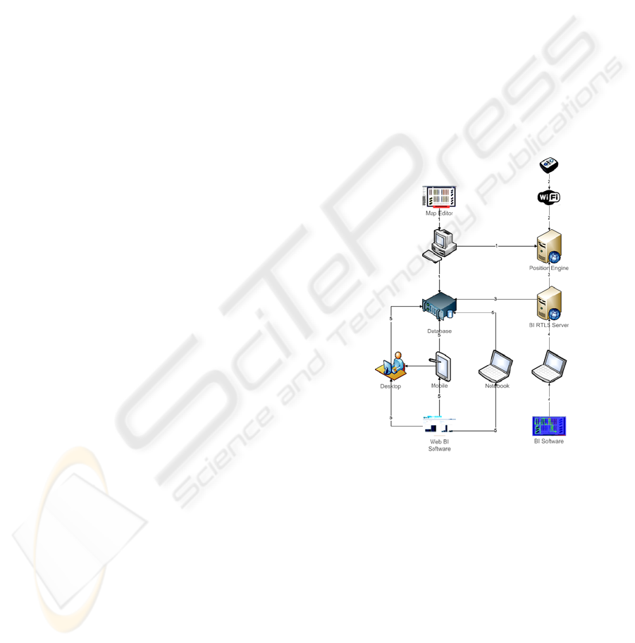
3 PROJECT DESCRITPION
In this section, the undertaken project is described in
detail in what regards its several components and
analysis perspectives.
3.1 Project Description
As revealed through Figure 1, the elaborated
technical design contemplates several independent
modules that communicate in order to achieve a
systematic unit. The first action, in offline mode,
consists in conducting a complete map
creation\edition. The user shall specify, amongst
other details, depicted in subsection 3.2, the image
file representing the shop floor layout, the used scale
and identify, by using a draw-like tool, what items
are to be visible by visitors as well as spawn areas.
This information is compiled in a XML file for both
the position engine and real-time monitoring tool
and submitted to the mentioned database for the
historical BI application.
The Wi-Fi tag consists in a miniaturized active
802.11 a/b/g board with a couple of power batteries
attached. These are configured to connect to a
specific Wi-Fi network – security, DHCP and other
network configurations are also possible – and to
directly communicate with the position engine. By
using this kind of wireless technology, it is possible
to reuse partially or totally the client’s network
infrastructure, having only, for special requirement,
a high density of access points as the accuracy
naturally increases with this factor.
The used position engine periodically collects data
from the tags and updates their position against a
pre-loaded localization model. This model is very
similar to the produced from the map editor differing
only in the available information regarding visible
objects. This model also requires a previous offline
site survey for measuring Wi-Fi signal strength and
for network items – routers and access points –
precise localization. The engine is also web-enabled
and supports a HTTP/XML API so that third-party
applications can interact with it, therefore accessing
localization and status information regarding each
individual registered tag.
Figure 1: System’s Global Architecture.
Using this communication protocol, the developed
real-time monitoring server is responsible for
gathering, at a specific periodicity – typically equals
to the position engine frequency – every tag’s valid
location data. With this information, this module is
directly responsible for updating the database and
caching the session’s data for the real-time
monitoring application.
Having the continuous up-to-date database as a solid
information reference, it was possible to enable both
real-time and historical business intelligence
applications. For real-time knowledge extraction, it
was only used data referring to active sessions, for
historical analysis, and delegating all the process
BUSINESS INTELLIGENCE BASED ON A WI-FI REAL TIME POSITIONING ENGINE - A Practical Application in a
Major Retail Company
13
effort to the database engine, specific and dynamic
time windows were used to filter data.
The versatility of such application must be referred
as it congregates both web-enabled features and zero
data process – it is all delegated to the database
engine and allocated in a dedicated server – enabling
its usage in a wide range of devices, including PDAs
and mobile phones.
3.2 Real-Time Monitoring Application
This unit is responsible for accessing location data
from the online position engine and, simultaneously,
using a multithread sliding-window approach,
commit new data to the database and compute data
into visual information following distinct
approaches. Each of these tool’s facets is mapped
into a distinct GUI tab enabling independent
analysis.
Before BI extraction, there are two mandatory
configuration requirements that must be met: the
first consists in loading the shop floor layout; the
second consists in establishing a HTTP connection
with the position engine. The third, optional,
requirement resides in opening a database
connection for online data insertion. If this is not
met, there are a virtual infinite number of
application’s instances that can be run at the same
time, enabling simultaneous BI extraction for
numerous organization’s members.
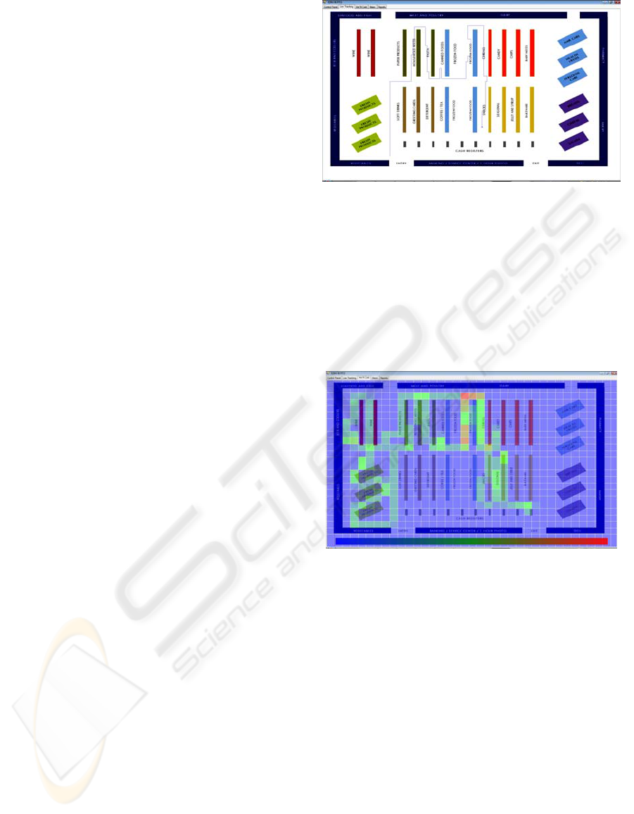
3.2.1 Real-Time Tracking
This feature enables complete item tracking by
overlapping current item’s position directly over the
loaded map information. This capability is
independent of the GUI’s windows size and/or shape
as the coordinate systems are always synchronized.
As depicted is Figure 2, it is also possible to enable
session’s path history directly over shop floor image,
therefore enhancing visual perception of both
current positions and session routes.
In the presented screenshot, it is possible to see
that at the time it was taken, there is only a single
client in the shop, whose location is near the layout
center and that his visit concentrated mainly in direct
routes in the north corridors.
If there would be more clients present, it would
be possible to perceive their current location by their
blue dots representation as well as, optionally
visualize their session routes.
This feature tries to emulate a bird’s eye view of
the all shop floor, with the possibility of recalling all
the client’s routes as if they left a visible trail while
they are touring the facility.
Figure 2: Real-Time Tracking with Visible Path.
3.2.2 Demographic Concentration
The demographic concentration feature enables
space division using a completely dynamic, in terms
of cell size, matrix grid that is colored according to
demographic concentration at given time. Once
again, this computation can be performed using only
strictly real-time positions or by recalling all current
session’s route positions.
Figure 3: Real-Time Tracking with Visible Path.
Each cell is then colored following a three-color
gradient where blue stands for lower levels of
concentration, green for intermediate levels and red
for high levels. A special remark is due to the fact
that the entire colour spectrum is used for the
mentioned purposes.
As illustrated in Figure 3, the concentration matrix is
drawn, with a partially transparency, over the shop
floor plant. In this practical example, the illustration
corresponds to a situation where there were two
clients present in the shop, and it was selected, for
concentration calculus concerns, not only current
position but all routes’ positions.
This tool’s feature enables swift, yet effective,
hot and cold zones analysis, current bottlenecks,
unvisited versus most visited areas and online queue
alerts and management. Also, as reported in the
previous subsection, all the graphical information is
independent of the GUI’s window size or shape.
ICEIS 2009 - International Conference on Enterprise Information Systems
14
3.3 Real-Time & Historical BI
Application
In order to extract significant business intelligence
knowledge based on historical data and not only
real-time information, the authors decided to make
an immediate use of the raw position data stored in
the database – in conjunction with visible structures
pre-processed information – so that significant retail
BI facts could be easily extracted and presented to
end-users – both shop managers and organization’s
top executives. Taking advantage of using Oracle as
equally laboratory and production database, Oracle’s
Application Express was used to generate a web
application responsible for processing data and, most
important, aggregate information in an
understandable way.
Apex’s engine is directly embedded to the
database, thus directly dealing with client’s web
requests. With this architecture, several systems can
easily access BI application as all heavy processing
is database server’s responsibility, leaving the client
with only chart rendering computation.
Despite extensive tool’s analysis being object of
discussion in the next section, by using the described
architecture and technology, several practical
measures were considered for extraction, namely:
hot and cold zones, average visit duration and
distance and number of visits. All these benchmarks
can be targeted to use only real-time data or recall
specific historical time windows.
4 RESULTS
One is able to state that the system performs swiftly
as a whole as its constituting parts are able to
exchange data harmoniously both in laboratory and
production environments. As for the core tool, the
real-time monitoring application, it was observed
that the displayed data is quickly interpretable, thus
making its purpose: enabling real time business
intelligence. In fact, just by looking, for instance, to
the grid tab, managers are able to see what the
current hot and cold zones are and make decisions
based on such information. According to the retail
store managers, by using the application, one is able
to, real time, assess the effectiveness of several
decisions, namely: the store’s layout, number of
open cash registers or the work being carried out by
employees in the zones where the customer service
is made face-to-face.
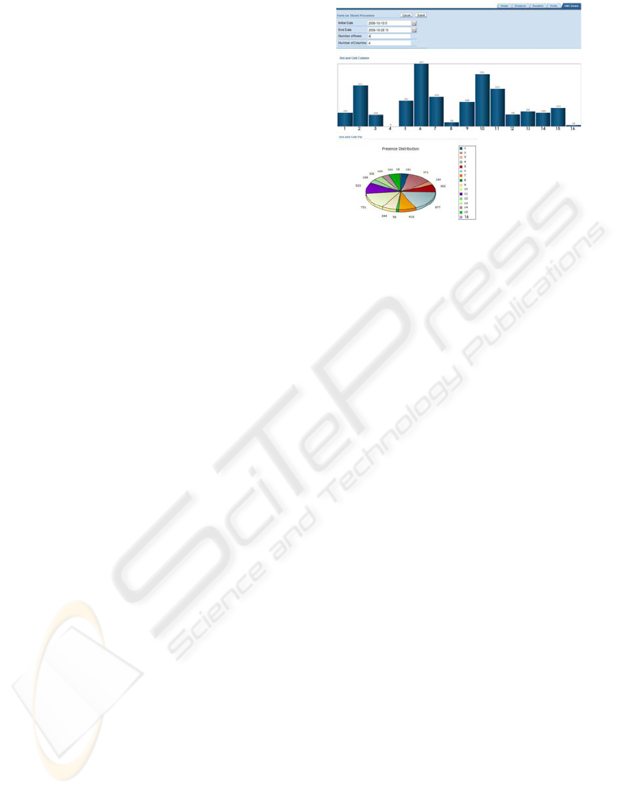
Figure 4: Web Application – Zone Distribution.
Figure 4 represents the retail store grid
concentration which has the layout as shown on
Figure 2. The data comprehends one week of
activity where each chart entry corresponds to the
number of accounted presences, on a specific zone,
every two seconds. The zones are numbered from
one to the number of rows times the number of
columns. Zone 1 is located on the top left corner.
By analyzing the exposed charts, some
interesting aspects on the customer’s behaviour
when visiting the shop, can be assessed. Although
zones 13 and 14 correspond to the store’s entry, it is
observable that very little time is spent by the
customers. Another interesting point resulting from
this analysis concerns the zones where more
presences were accounted. All of them include
central corridors, which are naturally part of the
paths that clients have to cross to reach the products
they are searching for.
5 CONCLUSIONS & FUTURE
WORK
One ought to affirm that all the most important goals
were fully accomplished. First, a fully functional
item real-time location and tracking system were
pursued. The Wi-Fi based solution, not only
complied but did it reusing most of the client’s
network infrastructure, thus reducing negative
impact in both financial and logistic terms.
Secondly, the designed system’s architecture proved
to be reliable, efficient and flexible enough to
contemplate vast and diverse application scenarios.
These features are more visible in what concerns
dynamic and user-friendly shop floor layout
definition. Also within this scope the distributed
communication architecture performed as predicted
BUSINESS INTELLIGENCE BASED ON A WI-FI REAL TIME POSITIONING ENGINE - A Practical Application in a
Major Retail Company
15

enabling computation across distinct machines,
therefore improving overall performance and
reliability. This feature also enabled simultaneous
multi-terminal access, both to the real-time analysis
tool and the historical statistical software.
Taking into consideration the project’s tools,
both were classified, by the retail company’s end-
users – mainly shop managers, marketing directors
and board administrators – as extremely useful and
allowed swift knowledge extraction, preventing
them the excruciating, and not often useless process
of getting through massive indirect location data.
The immediate visual information provided by the
system proved to be effective in direct applications
such as queue management and hot and cold zones
identification, and most significant, in what concerns
to visit’s pattern extraction across different time
dimensions, thus enhancing marketing and logistic
decisions’ impact. One must refer to Oracle’s APEX
technology adoption. It has demonstrated to be able
to allow multiple simultaneous accesses and,
consequently, dramatically enhancing analysis
empowerment, while, at the same time, eliminated
heavy data computation from end-users terminals,
concentrating it in controlled and expansible
clusters.
Regarding future work areas, there has been
identified a set of potential project enhancements
that would be able to suppress some hurdles and,
somehow, wide potential new applications.
Considering business intelligence extraction, it
would be useful to build or reuse an inference engine
capable of determining the odds of a given customer
turn right or left in the next decision point, taking for
that, into account his past actions and comparing
them to other customers’ action that are classified in
the same cluster. This aspect should be also applied
to historical data so that efficient customer clusters
would be defined and maintained.
There have been identified several application
domains that go beyond the retail segment. Amongst
these, one shall mention the possible system’s
adoption by large warehouse management where
traffic jams are not unusual.
As a summary, it is fair to state that the project’s
initial ambitions were fully met and that the close
cooperation with an important stakeholder in the
global retail market was extremely important for
better measuring the system’s positive impact and
potential firstly unseen applications. The technology
transparency, allied with the future work areas, is
believed to greatly improve potential applications in
several domains, thus significantly widening the
project’s initial horizons.
REFERENCES
C, C., J, Y., and W, J. Determining technology trends and
forecasts of RFID by a historical review and
bibliometric analysis from 1991 to 2005. In
Technovation27, Elvisier Ltd, page 268-279, 2007.
Cai, Q. and Aggarwal, J. Tracking human motion in
structured environments using a distributed camera
system. In IEEE Trans. Patt. Analy. Mach.
Intell.,pages 1241–1247, 1999.
Collins, R., Lipton, A., Fujiyoshi, H. and Kanade, T.
Algorithms for cooperative multisensory surveillance.
In Proceedings of IEEE, pages 1456–1477, 2001.
Elgammal, A., Duraiswami, R., Harwood, D. and Davis,
L. Background and foreground modeling using
nonparametric kernel density estimation for visual
surveillance. In Proceedings of IEEE, pages 1151–
1163,2000.
Huang, T. and Russel, S. Object identification in a
Bayesian context. In Proceedings of International
Joint Conference on Artificial Intelligence, pages
1276–1283, 1997.
Jappinen, P. and J, P. Preference-aware ubiquitous
advertisement screen. In e-commerce 2007
Proceedings, IADIS Press, pages 99–105, 2007.
Javed, O., Rasheed, Z., Shafique, K. and Shah, M.
Tracking across multiple cameras with disjoint views.
In IEEE International Conference on Computer Vision
(ICCV), pages 952–957, 2003.
Kettnaker, V. and Zabih, R. Bayesian multi-camera
surveillance. In IEEE Conference on Computer Vision
and Pattern Recognition, pages 117–123, 1999.
Khan, S. and Shah, M. Consistent labeling of tracked
objects in multiple cameras with overlapping fields of
view. In IEEE Trans. Patt. Analy. Mach.Intell., pages
1355–1360, 2003.
Lee, L., Romano, R. and Stein, G. Monitoring activities
from multiple video strams:establishing a common
coordinate frame. In IEEE Trans. Patt.Recogn.
Mach.Intell., pages 758–768, August 2000.
MacCormick, J. and Blake, A. Probabilistic exclusion and
partitioned sampling for multiple object tracking. In
Int. J. Comput. Vision, pages 57–71, 2000.
Mingkhwan, A. Wi-fi tracker: An organization wi- fi
tracking system. In IEEE CCECE/CCGEI,
Ottawa,page 1353-1356, 2006.
Mittal, A. and Davis, L. M2 tracker: A multiview
approach to segmenting and tracking people in a
cluttered scene. In Int.J. Comput. Vision
, pages 189–
203, 2003.
Nejikovsky, B., Kesler, K. and Stevens, J. Real time
monitoring of vehicle/track interaction. In Rail
Transportation, pages 25–31, 2005.
Yu, Z. GPS train location and error analysis which based
on the track fitting of the railway’s geometric locus. In
ICEMI 2005: Conference Proceedings of the Seventh
International Conference on Electronic Measurement.
ICEIS 2009 - International Conference on Enterprise Information Systems
16
