
gvSIGDROID
An Open Source Gis Solution for the Android Platform
Cristian Martín-Reinhold, Joaquín Huerta and Carlos Granell
Centre for Intreactive Visualization, Department of Information Systems
Universitat Jaume I, Avda Vicent Sos Baynat s/n, Castellón de la Plana, Spain
Keywords: Mobile GIS Applications, Open Source, gvSIG, Android, Web Services, OGC.
Abstract: Mobile GIS applications are gaining attention due to a wide range of potential target applications such as e-
commerce, tourism, education, agriculture, and field research. This requires easy-to-use geospatial
applications operating on mobile devices to enable both visualization and editing of widely-used geospatial
data and formats. This paper introduces gvSIGDroid, an open source geospatial mobile application that
attempts to reach the new potential users emerged from the Android platform. The prototype’s core
functionalities rely on gvSIGMobile modules together with an especially designed user interface for the
Android platform, allowing mobile users to retrieve, visualize, navigate and modify both local and remote
geospatial layers. Future extensions can be deployed so as to provide missing functionalities such as
Location Based Services and data sharing.
1 INTRODUCTION
Mobile devices, mostly in the form of PDAs
(Personal Digitalized Assistant) and mobile phones,
have nowadays changed access to information and
services from desktop devices to ubiquitous
computing (Goodchild, Johnston, Maguire and
Noronha, 2004). This new environment has led
companies to migrate and readapt their traditional
desktop software applications in order to obtain the
best mobile customers’ experience on a user-centred
scenario (Boll, Breunig, Jensen, König-Ries, Malaka
et al., 2004), by providing solutions based either on
open source software or commercial packages.
In the Geographical Information Systems (GIS)
context, mobile GIS applications can be generically
classified into field-based GIS solutions and
Location Based Services (LBS) applications
(Schiller and Voisard, 2004). The former have a
long history since first GIS users already used maps
to collect and visualize geographic information
(Brown, 1949). On the other hand, LBS applications
aim to offer location-based functionality, such as
navigation, street and service finding, and route
tracking. These services are normally developed as
web applications like the Open Route Service (Neis
and Zipf, 2008; http://openrouteservice.org)
This paper describes the first results of
gvSIGDroid, an ongoing prototype fully developed
with open source tools and components on top of the
recently emerged Android mobile platform
(http://www.android.com/). Although it is still an
initial release, gvSIGDroid provides a complete GIS
mobile application with common GIS functionalities
that allows users to manage locally geospatial data,
either in vector (in the form of points, lines,
polygons) or raster formats (any kind of image
format). Besides, the application permits to connect
to remote services like web mapping services
compliant with the Open Geospatial Consortium
(OGC, http://www.opengeospatial.org/) service
specification Web Mapping Service (WMS) (de la
Beaujardiere, 2006). Essentially, the WMS
specification describes a set of HTTP-based service
interfaces so that any client application like
gvSIGDroid may connect, query and retrieve maps
from any remote WMS-compliant mapping service
elsewhere.
The rest of the paper is organized as follows.
Next section describes the conceptual architecture
that supports gvSIGDroid. Section 3 shows the first
results achieved by the gvSIGDroid application.
Finally, in section 4 we provide our conclusions and
suggest future developments and research lines.
195
Martà n-Reinhold C., Huerta J. and Granell C.
gvSIGDROID - An Open Source Gis Solution for the Android Platform.
DOI: 10.5220/0002796101950198
In Proceedings of the 6th International Conference on Web Information Systems and Technology (WEBIST 2010), page
ISBN: 978-989-674-025-2
Copyright
c
2010 by SCITEPRESS – Science and Technology Publications, Lda. All rights reserved
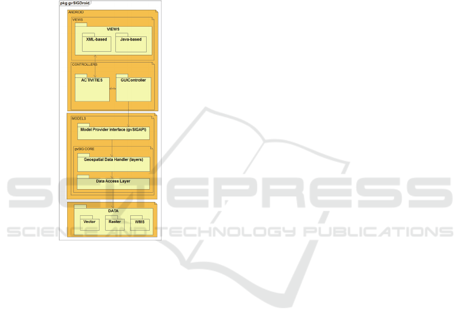
2 ARCHITECTURE
gvSIGDroid application comprises various open
source components following a conceptual
architecture based on the Model-View-Controller
paradigm (MVC), as illustrated in Figure 1.
Wrapping classes that extend the built-in classes
were created to complement and simplify from the
developer’s perspective the interaction with the
Android platform’s components.
Figure 1: gvSIGDroid's architecture.
As shown in Figure 1, different modules have
been implemented to offer users a logical way of
interacting with the application. So, each module
contains Java classes of all three MVC layers: a set
of classes used represents the Presentation or View
layer, the Controllers and Activities corresponds to
the Controller layer, whereas the whole gvSIG core
along with the Model Provider Interface API class
constitute the Model layer.
2.1 View Layer
The View or Presentation layer contains all the
components that exploit the Android’s graphic
utilities and capabilities to develop the application
user interface. Accordingly to the Android
architecture (Android, 2008), the Android platform
admits two mechanisms for creating user interfaces,
one based on java code and other in XML
declarations (similar to Flex user interfaces
developments). In our application, we offer a View
class that encapsulates both Android’s mechanisms
as a base class for creating and instantiating all of
the graphical objects used. In essence, once
instantiated a graphical object, it delegates to native
Android methods for input and output operations
such as input user and drawing capabilities.
2.2 Controller Layer
The aim of the Controller or Business Logic layer is
to constantly catch any user request via the View
objects of the Presentation layer, and also to delegate
these requests to the most appropriate component.
The first task is handled by the Activities, which
contain the main graphical user interface and
Android Controllers from the Android application
framework layer.
Within the Activities, these Android Controllers
are in charge of handling events triggered on user
interface objects, like onClick() for images and
buttons or onListItemLongClick() for items of a
ListView. In addition Activities handle system
events, like the onPause() event fired when another
application of the system is going to gain the focus
(an incoming call for example). All these scenarios
must be correctly handled for every module.
Apart from the events aforementioned, there are
several actions that need to be handled on a View as
well, which are:
At Business Logic level: Calling other activities.
For example, showing a new screen implies the
task of calling to a new activity, which will be
handled by the GUIController class.
At Model level: To provide the information
needed from the internal gvSIG data model,
which should not require any graphical control, a
different controller that implements a Model
Provider Interface was used.
2.3 Model Layer
The main goal of the Model layer is to enable data
persistence. This is achieved using the data model of
gvSIGMobile, so that our application exploits all the
geospatial data capabilities already supported in
gvSIGMobile. However, other components were
created to facilitate the access and retrieval of
datasets from remote services.
The bottom of Figure 1 shows the components
involved in the Model layer. From top to bottom, we
have the ModelProviderController component. It
provides an internal model that abstracts the core
gvSIGMobile data model (Geospatial Data
Handler). The ModelProviderController delegates
WEBIST 2010 - 6th International Conference on Web Information Systems and Technologies
196
the tasks of retrieval and storing of geospatial layers
to the gvSIGMobile module, permitting thus a
loosely coupled design.
Besides the layer management capability, the
ModelProviderController also links to the core
module of gvSIG (Data Access Layer). This module
contains the business logic necessary to manage
vector and raster data formats as well as handling
remote geospatial layers from WMS services into
gvSIG-compliant layer objects. Furthermore, the
ModelProviderController component allow us to
proxy all the data handler and access capabilities to
gvSIG and gvSIGMobile modules, which have
proven to be successful in diverse production
applications.
3 RESULTS
The main purpose of gvSIGDroid is to exploit
Android SDK to provide a user-friendly application,
which results more in keeping with the user’s
expectation. As gvSIGMobile has been recently
released, some of their potential functionalities were
not available on the first prototype of gvSIGDroid,
like for instance advanced edition capabilities and
Global Positioning System (GPS) support.
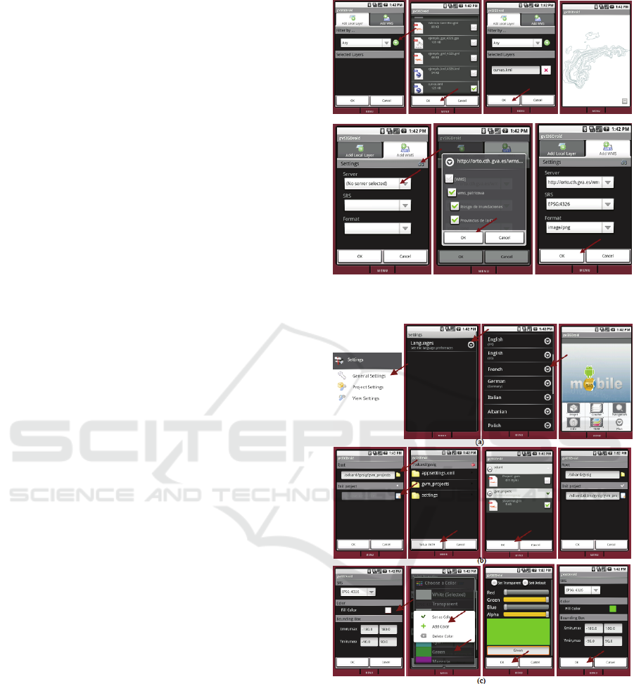
3.1 Layers Module
Figure 2 illustrates the use cases for adding both
local and remote layers into gvSIGDroid. Figure
2(a) guides the use in adding a local layer. After a
filter for the file browser is selected (shp, kml, gml,
etc.), all available layers are listed. Then, users just
need to choose the preferred layer to visualize it.
The second row of images in Figure 2 lets users
connect to WMS services to retrieve remote layers.
This option is only possible when an Internet
connection is available. As shown in Figure 2(b) a
server can be selected based on a given list and a
dialogue window appears, letting the user select the
layers of interest to be loaded. Here, the gvSIGDroid
application makes use of the Data Access Layer
module (See Figure 1) in order to connect and
interact with WMS services according to its
specification. Once the dialogue is dismissed by
pressing OK, some of the layer’s properties like
format (Format textbox) and reference system (SRS
textbox) can also be adjusted. Finally, when pressing
again the OK button the selected layers will be
loaded into the project as in the case of adding local
layers.
(a)
(b)
Figure 2: Adding a local (a) and a remote (b) layer.
Figure 3: General (a), project (b) and view (c) settings.
3.2 Navigation and Settings Modules
Users also need to navigate through the layer, being
able to perform actions like zooming in, zooming
out, re-centering the layer by point, measuring paths
and areas, and so on. For managing this actions, no
views were needed, just a context dialogue was
implemented to let the user select between these
different commands from a corner of the map view
panel.
gvSIGDROID - An Open Source Gis Solution for the Android Platform
197

Figure 3a shows the general settings (language,
locale, etc.). Figure 3b illustrates the options
supported for project configuration: setting the
default root from which file browsers will start, and
setting a gvm file to be initialized each time the
application re-launches. Finally, Figure 3c shows
some configuration screens for view settings.
4 CONCLUSIONS AND FUTURE
WORK
This paper has described a first attempt in migrating
gvSIGMobile software into the Android platform.
After some difficulties integrating both libraries, the
first prototype implementation, with the aid of the
full graphical user interface in Android, led to a
clean, nice and user-friendly interface.
gvSIGDroid allows to GIS mobile users to
manage almost any kind of geographic data
resource. Consequently, users can load, access, edit,
and visualize geospatial data about their
surroundings from the field, facilitating on-the-fly
decision-making. Most importantly, this application
allows user to connect and access to remote web
map services in compliance with the OGC WMS
specification. This means that gvSIGDroid is in the
way to becoming a mobile SDI client for Spatial
Data Infrastructure. Future work in this direction
will be focused on supporting other standard
geospatial services, like Web Feature Services
(Vretanos, 2005) for retrieving remote vector data
(e.g. GML files).
Nevertheless, the first release contains several
inconveniences. For example, the loading and
drawing of the layers take much longer than in
gvSIGMobile. This is due to the fact that
gvSIGDroid first uses the core objects as they were
designed in gvSIGMobile, before adapting them to
its unique Android objects for drawing, consuming
substantial time and resources. In future
implementations, this limitation may be addressed
by transforming the core module that contains
gvSIGMobile objects into native Android core
objects. Another inconvenience for field-based
researchers when using gvSIGDroid is that, within
the program, there is still no possibility of taking
advantage of the GPS hardware of the device, since
the GPS module has not been yet implemented.
Some future work should be done in order to
enhance gvSIGDroid with a wide set of GIS
functionalities. On the one hand, it is important to
explore new ways of loading big shapefiles more
efficiently. As said, the core module should be re-
implemented to provide Android shapes’ inner
classes at earlier stages and merge both Android and
gvSIG data shape models for drawing.
ACKNOWLEDGEMENTS
This work has been partially supported by the EC
Erasmus Mundus Programme M. Sc. in Geospatial
Technologies. We would also like to thank the
Prodevelop staff for their invaluable collaboration
and help in the use of gvSIGMobile.
REFERENCES
Android, (2008). Android Architecture. Retrieved October
24, 2009 from http://developer.android.com/guide/
basics/what-is-android.html
de la Beaujardiere, J (ed.) (2006). OpenGIS Web Map
Service (WMS) Implementation Specification, version
1.3.0. Open Geospatial Consortium, Implementation
Specification.
Boll, S., Breunig, M., Jensen, C. S., König-Ries, B.,
Malaka, R., Matthes, F., Panayiotou, C., Saltenis, S. &
Schwarz, T. (2004). Working Group - Towards a
Handbook for User-Centered Mobile Application
Design In Proc. of Mobile Information Management.
Dagstuhl: IBFI.
Brown, L. B. (1949) The Story of Maps. New York:
Bonanza Books.
Goodchild, M. F., Johnston, D. M., Maguire, D. J., &
Noronha V. T. (2004). In R. B. McMaster & E. L.
Usery, (Ed.), A Research Agenda for Geographic
Information Science. Distributed and mobile
computing., (pp. 257-286). Boca Raton: CRC Press.
Haklay, M. & Weber, P. (2008). OpenStreetMap: User-
Generated Street Maps. IEEE Pervasive Computing,
7(4): 12-18.
Neis, P. and Zipf, A. (2008): Extending the OGC OpenLS
Route Service to 3D for an interoperable realisation of
3D focus maps with landmarks. International Journal
of Location Based Services 2(2): 153-174.
Schiller, J. & Voisard, A, (eds) (2004). Location-Based
Services. Morgan Kaufmann.
Vretanos, P. A. (ed.) (2005). Web Feature Service (WFS)
Implementation Specification, version 1.1.0. Open
Geospatial Consortium, Implementation Specification.
WEBIST 2010 - 6th International Conference on Web Information Systems and Technologies
198
