
RecRoute
A Bus Route Recommendation System Based on Users’ Contextual Information
Adriano de Oliveira Tito, Arley Ramalho R. Ristar, Luana M. dos Santos, Luiz Antonio V. Filho,
Patrícia Restelli Tedesco and Ana Carolina Salgado
Center for Infomatics, Federal University of Pernambuco, Recife, Brazil
Keywords: Intelligent Transportation Systems, Recommendation Systems, Context-Aware Computing.
Abstract: Traffic has become an increasingly significant problem in the lives of citizens of major and medium sized
cities. This has contributed to the inefficiency of public transportation, where one of the main issues to be
tackled is the absence of relevant, timely information to users. In times where technology solutions for daily
tasks are widely available, Public Transportation User Information Systems emerge as a possible solution to
this issue, providing information to passengers and supporting their decision-making. This work aims to
present a recommendation system for public transportation routes by bus, called RecRoute, that considers
contextual information related to users, climate, time of day and traffic to recommend bus routes that are
more adequate to the passengers’ particular needs. The results of our experiment show that RecRoute was
approved and its recommendations were well evaluated by the participants.
1 INTRODUCTION
Traffic in big cities is getting worse daily. With the
increasing number of private cars on the roads,
traffic jams have become more and more frequent.
According to Zhang and colleagues (2011),
widening streets, building overpasses or rotating cars
are not viable alternatives for improving traffic. To
this end, it is necessary that the government and the
operators of public transportation provide better
service, motivating users to use public transportation
(Pilon, 2009). According to Cutolo (2003), the main
barriers to the use of public transportation by bus lie
in the lack of information about the services and low
quality.
In this light, Intelligent Transportation Systems –
ITS - aim to implement technologies to support the
infrastructure and improve the quality of transport
systems (Gómez et al., 2009). One of the subareas of
ITS is called Advanced Public Transportation
Systems - APTS, which consists of applications of
ITS aimed at increasing the efficiency and safety of
public transportation systems (Sussman, 2005). In
the context of APTS, there are User Information
Systems which constitute an important tool for
communication between operators / managers and
public transportation users. Such tools can provide
passengers with information that meets their specific
needs, expected arrival times of buses, the next
vehicle to pass in the bus stop and route
recommendations to users (Pilon, 2009).
Thus, in most cases, passengers of public
transportation do not count with services that
support them in choosing which bus and route take
to reach their destinations. These services consider
avoiding heavy traffic or accidents and taking into
account passengers’ current preferences. In our
research project, called Ubibus (Vieira et al., 2011),
we have proposed solutions to enable the use of
mobile technologies and contextual information as
support for public transportation passengers in large
and medium-sized urban centers.
In this scenario, we present RecRoute: a context-
sensitive route recommendation system for public
transportation. RecRoute takes into account the
context of the passengers as well as climate, time of
day and current traffic situation. One major feature
of our system is the acquisition and processing of
contextual information from several sources.
The paper is organized as follows: Section 2
introduces concepts related to ITS, Context and
Recommender Systems; Section 3 presents the
Ubibus project; Section 4 presents RecRoute;
Section 5 presents the experiments carried out and
their results; Section 6 presents the related woks and
Section 7 concludes the paper with some final
357
de Oliveira Tito A., Ramalho R. Ristar A., M. dos Santos L., Antonio V. Filho L., Restelli Tedesco P. and Carolina Salgado A..
RecRoute - A Bus Route Recommendation System Based on Users’ Contextual Information.
DOI: 10.5220/0004866903570366
In Proceedings of the 16th International Conference on Enterprise Information Systems (ICEIS-2014), pages 357-366
ISBN: 978-989-758-027-7
Copyright
c
2014 SCITEPRESS (Science and Technology Publications, Lda.)

remarks and future work.
2 BASIC CONCEPTS
This section presents some concepts of Intelligent
Transportation Systems, Context and Recommender
Systems.
2.1 Intelligent Transportation Systems
Intelligent Transportation Systems (ITS) investigate
the application of technologies of communications,
control, electronics and computer hardware and
software to the surface transportation system in
order to improve its quality (Sussman, 2005). Other
environmental benefits can be obtained through the
use of ITS, such as better rates of air pollution. With
better traffic flow, greenhouse gas emissions will be
reduced (Pilon, 2009).
There is also a sub-area of ITS called User
Information Systems, that provides real time
information regarding transportation availability in
order to help users plan their trips.
Some solutions for User Information Systems
already operate in developed countries, where the
road system ensures efficient information about
public transportation.
In towns with constant traffic congestion, and
inefficient road systems, it is necessary to consider
information beyond what is stored in databases (e.g.
bus stop locations). The use of contextual
information may help applications to become more
adaptive for passengers, satisfying their needs and
preferences.
2.2 Context
Computational Context can be seen as a set of
conditions and influences relevant for an application
and which make a situation unique and
comprehensible (Brézillon, 1999). Context-Sensitive
Systems are applications that adapt themselves
without explicit user intervention, that is, they take
into account information on the situation where the
user is inserted to provide better services, thus
increasing their usability and effectiveness
(Baltrunas, 2011).
According to Vieira and colleagues (2009), the
context of the interaction between an agent and an
application to perform a task, is the set of
instantiated contextual elements that are needed to
support the current task. A contextual element is any
data, information or knowledge that allows us to
characterize an entity in a domain.
2.3 Recommender Systems
To Baltrunas (2008), Recommender Systems (RS)
are powerful tools that can help the user face the
problem of information overload by providing
personalized recommendations. The main goal of
recommender systems is to make suggestions for
various services according to predetermined user
profiles (Chorianopoulos, 2008).
RS can, for example, help the user to choose a
travel plan, indicating places to visit options, hotels,
and airlines, according to user preferences displayed
on your profile.
There is still room for improvement.
Traditionally, such systems are based only on user
profiles or static variables, and do not take into
account the changing circumstances that may
influence the user's interests. Thus, the incorporation
of contextual information in the recommendation
process is highlighted in the literature as a possible
extension to the traditional recommender systems
(Adomavicius and Tuzhilin, 2008).
To Baltrunas (2011), a recommendation can
often be more relevant if the context is known. For
this reason, Context-Aware Recommender Systems -
CARS, are gaining more prominence, and various
approaches have been used incorporating the
knowledge of the context. Thus, the new generation
of recommender systems should explore context
information to provide better recommendations.
3 THE UBIBUS PROJECT
The Ubibus project aims to facilitate the daily lives
of public transportation users, providing intelligent
access to information of this type of transport to the
passengers in real time, based on dynamic
contextual information related to their own means of
transport (Vieira et al., 2011).
Figure 1 shows the Ubibus architecture. The
Data Level is responsible for the management of
information such as location, speed, bus route,
locations of the bus stops, location of passenger,
information of real-time traffic, maps and other.
Information about jams is used to identify
obstructions in the flow of traffic and their level, for
example, slow traffic, moderate or congested.
The Middle level of the system consists of a
middleware that facilitates communication and
coordination among software components
distributed transparently addressing the difficulties
ICEIS2014-16thInternationalConferenceonEnterpriseInformationSystems
358
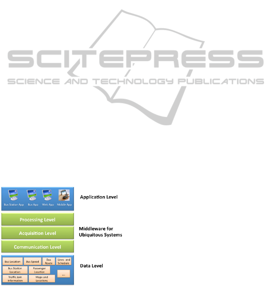
and complexities introduced by wireless
communication and mobility, for example, access to
applications for different types of devices.
The proposed middleware is multiparadigm and
extensible, since it proposes to support a set of
communication paradigms, and meet different types
of applications, for example, mobile and web. To
optimize the use of resources of the mobile devices
integrated to the project, the middleware provides
sharing and reuse of components. It is divided into
three levels:
Communication Level: provides access to data,
as well as real-time updates to managers, operators,
users and drivers. The advances and standardization
of wireless communication technologies, such as
WiFi, Bluetooth, WiMAX, GPRS and 3G, allow
communication of short and long reach, making it
possible to develop applications for web, desktop,
PDA, mobile phones, terminals and kiosks, for
example, bus stops and bus stations;
Acquisition Level: is responsible for gathering
contextual information from different sources, and
for routing them to the Data Level. In Ubibus,
contextual information may be obtained from
sources such as social networks (e.g., Twitter and
Facebook), GPS and monitoring cameras. Such
information may be dynamic (e.g. the location of the
bus) or inferred, for example, the discovery of a
traffic jam and its intensity;
Processing Level: aims to carry out the treatment
of the context information acquired from different
sources in order to transform them into useful
information for the applications to be developed. For
example, regarding the source of GPS context, the
Processing Level is responsible for receiving files
with the locations and velocities of the bus at a given
time frequency, and processing them so that they are
Figure 1: The Ubibus Architecture Overview (Vieira et al.,
2011).
properly stored in the data layer.
The Application Level contains different types of
applications developed. These applications fit the
different platforms and devices such as web,
desktop, PDA, mobile phones and displays.
4 THE RecRoute SYSTEM
The integration of various technologies has enabled
ITS to evolve significantly. Consequently, there is
an increasing demand for systems that are dynamic
and context-sensitive. In particular, several route
recommendation systems are being used as a way of
providing users with timely, relevant information.
In RecRoute, contextual information allows the
system to understand the user's preferences, weather
conditions and traffic situation in order to adjust the
results to the needs of passengers.
This section is divided into two parts. The first is
the specification of RecRoute and the second part
discusses how we have chosen the ranking algorithm
used in the implementation of RecRoute.
4.1 The Specification of RecRoute
In this section, we present the modeling of
contextual information, architecture and
specification details of RecRoute, an application
with mobile and web interfaces for recommending
routes to public transportation users, based on
contextual information of users, traffic and other
urban factors that may affect it, such as the weather.
4.1.1 Modeling Contextual Information
To provide recommendations that are more
appropriate to the needs of users, RecRoute uses
static, dynamic and inferred contextual information.
By considering the changes in contextual
information, RecRoute can provide users with
suggestions more targeted to their needs, considering
that traffic has dynamic characteristics which
incidents can, at any time, directly influence its
status. Therefore, this section aims to show how the
contextual requirements were elicited.
Initially we conducted a survey of contextual
information about users' preferences that would
possibly be useful for the passengers of public
transportation during the recommendations. Such
information are: shorter distance to be traveled,
shorter travel time, lower ticket fares, bus exchange
during displacement and distance to be traveled on
foot.
RecRoute-ABusRouteRecommendationSystemBasedonUsers'ContextualInformation
359
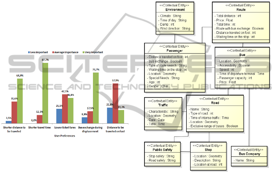
To validate the preferences initially considered,
we developed a questionnaire that was answered by
57 people, including students and users of public
transportation by bus. Respondents were asked to
rank the contextual information we provided and
suggest any others they might have thought relevant.
By consolidating the results, we realized initially
that preferences were considered “Very Important”
and with “Average Importance” with special
emphasis on the shorter travel time with almost 90%
of relevance, the shorter distance to be traveled and
bus exchange during displacement with 64.9% and
73.7% of relevance, respectively. It was also
observed that none of the preferences initially
suggested was classified as “Less Important” by
most respondents, as shown in Figure 2.
Figure 2: Relevance of User Preferences.
In addition to answers about the relevance of
preferences, the waiting time at the bus stop was
suggested by 60% of respondents as contextual
information to be considered during the
recommendations.
After analyzing the questionnaires, we were able
to model more precisely the contextual information
related to user preferences and other entities that are
used by RecRoute. Figure 3 shows the model of
contextual information used by RecRoute based on
the UML metamodel proposed by Vieira (2009).
Among the contextual information modeled in
Figure 3, RecRoute considers the following entities:
Passenger: relates to the requesting user and their
preferences.
Location: represents the geographic location of the
user who is requesting the suggestion of routes.
Special Needs: this information is important for
the system because it informs if the user has some
kind of disability such as mobility impairment
(wheelchair), visual or hearing disability.
Distance Traveled on Foot: This attribute tells
what is the maximum distance in meters the user
tolerates to walk.
Bus Exchange: it represents the user's
preference for routes that have bus exchanges to be
made along the way.
Type of Route Search: it represents the user's
preference for the type of search to be performed
among the routes, for example, smaller distance,
smaller fare or less time spent.
Figure 3: Modeling of Contextual Information.
Waiting Time on the Stop: this information
means the maximum time in minutes that the user
will stand waiting at the bus stop.
Environment: this information concerns the
environment in which the user is. For us the climate,
time of day and other issues are important to the
recommendations made by RecRoute because they
can greatly influence the classification of routes and
consequently the recommendations. We take into
consideration:
Climate: it represents the weather conditions at the
time of the recommendation, such as rainy, sunny
or cloudy.
Time of Day: the information represents the time
of day that the request is occurring as the morning
(6:00 to 11:59 h), afternoon (12:00 to 17:59 h),
night (18:00 to 05:59 h) or rush hour.
ICEIS2014-16thInternationalConferenceonEnterpriseInformationSystems
360
Route: routes may have many contextual
information. The ones considered by RecRoute are:
Total Distance: total distance to be traveled in
meters.
Total Time: total time spent to traverse the route.
Price: total cost of the route.
Route with Bus Exchange: it informs whether the
user will need to exchange buses during their
journey.
Distance Traveled on Foot: indicates the distance
to be covered on foot by the passenger.
Waiting Time on the stop: this information
relates to how long in minutes the user should
remain waiting for the transport.
Bus: contextual information are as follows:
Location: this information relates to the location
of the bus at the time of the user request.
Accessibility: it reveals whether the buses that
travel the route have accessibility feature or not.
Price: corresponds to the cost of the ticket.
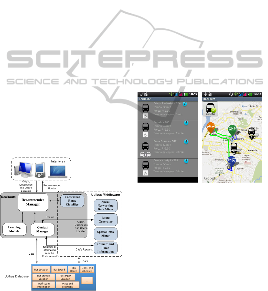
4.1.2 RecRoute Architecture
RecRoute uses various features offered by the
Ubibus middleware, such as the interfaces, the
database, the service Route Generation that retrieves
routes enriched for contextual elements of traffic
according to the source and target passed by the user
and the service Climate and Time Information which
provides contextual information for climate and time
used in the recommendations of routes. Figure 4
shows the RecRoute architecture.
Figure 4: RecRoute Architecture Overview.
Four main components are present in the
architecture of RecRoute: the Recommender
Manager is responsible for the orchestration of the
execution flow of the recommendation process; the
Context Manager manages the acquisition of
contextual information to be used by RecRoute, the
Learning Module is responsible for the classification
of routes and the Contextual Route Classifier
responsible for ordering the routes. This last
component is part of the Ubibus Middleware and
also offers its services to other applications. Routes
are classified by their characteristics considering the
point of origin and destination chosen by the user.
Interfaces: The users communicate with
RecRoute through its Web and Mobile interfaces.
The mobile interface has the benefit of being
portable, allowing the user to make a decision en
route, even if not at the bus stop or at home. This is
similar to the web Interface adapted for mobile
devices and also has the possibility of using the
georreferenced position of the user device more
precisely. Figure 5 shows screenshots of the mobile
interface.
Figure 5: Example of the Mobile Interface.
Recommender Manager: The Recommender
Manager is the core component of RecRoute and
manages all application actions, for example, the
calling of other components of the architecture. It is
through this element that all actions performed by
the users through the interfaces access to system
functionality.
Context Manager: The Context Manager is
responsible for managing all contextual information
that will be used for the recommendation. This
component communicates with Ubibus middleware
services to obtain the necessary data such as the
initial set of routes provided by the Route Generator
for the origin and destination as well as climate and
temporal information.
RecRoute-ABusRouteRecommendationSystemBasedonUsers'ContextualInformation
361
Learning Module: This module manages the
function used for the classification of routes through
supervised learning (training) incrementally. In this
process, we have formed a set of training records,
called the training set, containing information about
the user's preferences, climatic and temporal
information, two options of the routes, and their
associated class labels, in this case the best route
between options presented (described in section 4.2),
and submitted them to a Naive Bayes classifier
(Friedman, 1997), generating a function.
The function, which results from the learning of
training records for the Naive Bayes classifier, is
stored in a structure in the database. Each function is
unique to the points of origin and destination
provided by the user upon request. Thus each
request that has the same origin and destination will
use the same function for classification.
Contextual Route Classifier: The Contextual
Route Classifier is the component responsible for
ordering routes using the function produced by the
Learning Module. Routes are classified by their
features, user preferences and chosen points of
origin and destination.
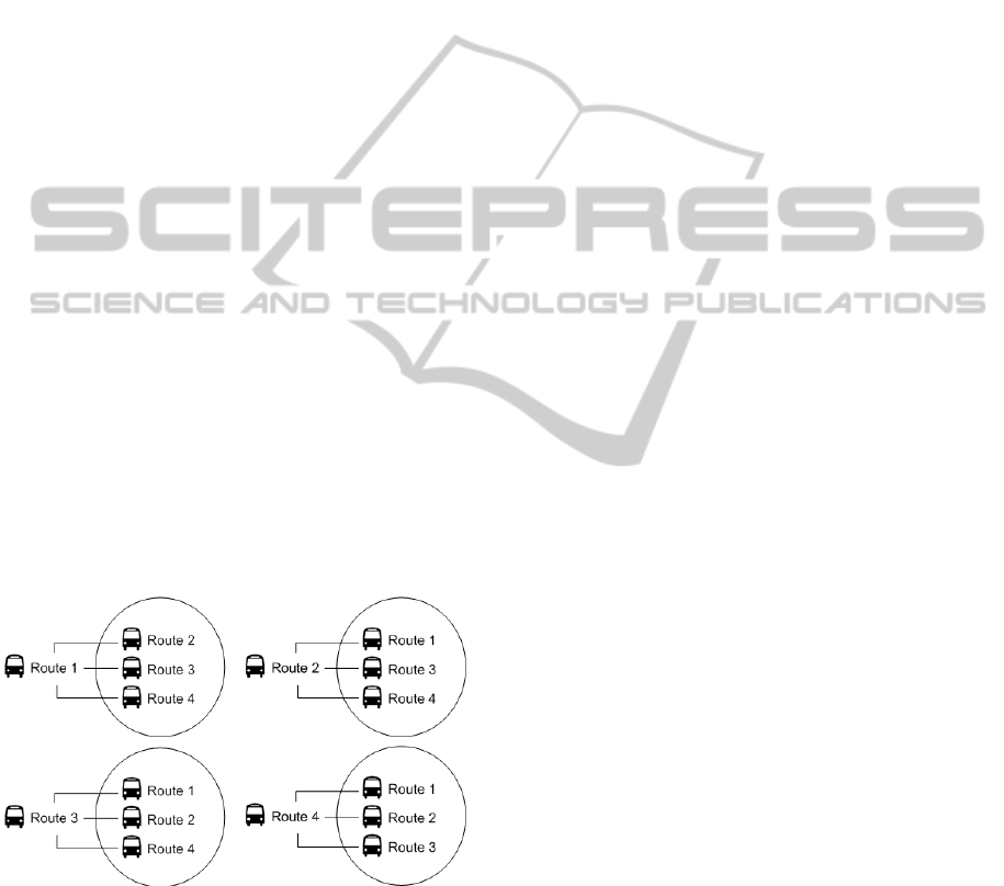
The classification of routes is carried out by
grouping them in pairs and using the expression
N*(N-1), where N is the initial number of routes,
resulting number of pairs.
For example, Figure 6 shows the formation of
pairs of routes for classification with a group of 4
routes. For this case 12 pairs of routes are formed,
these pairs are repeated alternating positions
between routes (first and second route).
Figure 6: Illustration of Grouping Routes to Classification.
This way of grouping in pairs to pass through Naive
Bayes was chosen because we believe that the
repetition of pairs alternating positions minimizes
the margin of error of classification. After the
formation of these pairs the classification starts.
After evaluating all pairs by sorting function and
the consolidation of scores, all routes are ordered
according to the score obtained by each route during
evaluations.
Middleware Services Used by RecRoute:
Route Generator: This component generates a
set of routes according to points of origin and
destination indicated by the user. Contextual traffic
elements such as traffic jams, hours of heavy traffic,
accidents, floods, social networking information and
other information are used to generate the routes.
Climate and Time Information: This component
is responsible for providing information about the
climate and weather that are used by RecRoute. To
obtain this information the Context Manager
informs the city from where comes the
recommendation and receives the climate situation
and time information in the locality.
Database: The database used by RecRoute is
shared with other applications and services of the
Ubibus Project. This database stores all obtained
contextual data about traffic, buses, routes, bus
stops, and passengers, among others.
4.2 Choice of the Classification
Algorithm
As described in Section 4.1.2, learning functions
were created through Naive Bayes algorithm to assist
in the route recommendation. These functions are
generated by processing a set of registers called the
training set.
The Naive Bayes algorithm is also used to update
functions, according to the user's choices among the
recommendations made by the system. Thus, we can
see that the choice of the classification algorithm is
very important in the scope of this project.
The experimental setting adopted to compare the
performance of algorithms aimed to verify which of
the algorithms - C4.5 (Quinlan, 1993), Naive Bayes,
Multilayer Perceptron (Mcculloch and Pitts, 1943) –
would perform better in the scenario of our
application.
In this experiment, the implementation of
machine learning algorithms was done with API
Weka (Waikato, 2010). Weka uses a file called
ARFF (Attribute-Relation File Format) file that
contains a set of records used in the learning task. In
the case of this study the ARFF consists of
contextual information of passengers, the
environment and bus routes.
The ARFF file consisted of records where each
row represents a comparison between two routes,
according to user preferences and climate and
temporal data. Figure 7 illustrates the format of
ICEIS2014-16thInternationalConferenceonEnterpriseInformationSystems
362
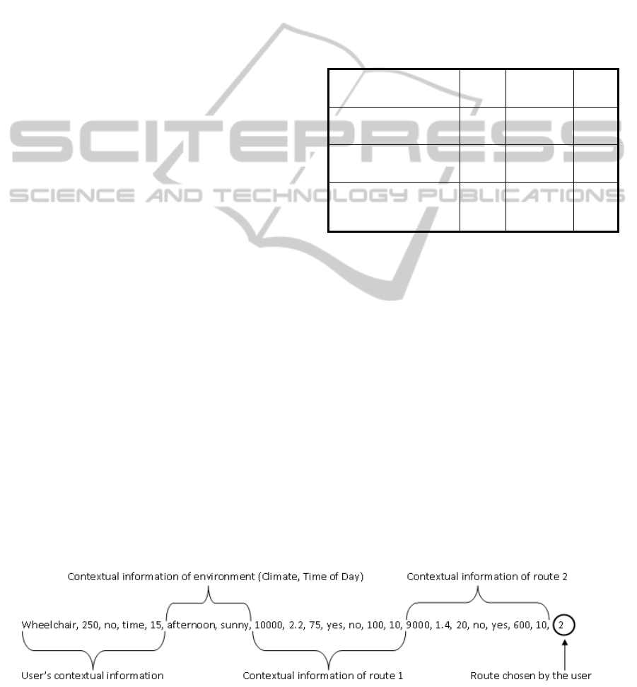
records contained in the ARFF file, comprising five-
parts:
The first represents the contextual information of
users, including special needs (if any), distance to be
traveled on foot in meters, preference by bus
exchange, search type of route (smaller distance, less
time or smaller price) and waiting time at the stop in
minutes;
The second represents the contextual information
of climate and time when the route was requested;
The third and fourth parts comprise the
information of the two routes being compared: total
distance to be traveled by the route in meters, total
price of route, total time in minutes, route with bus
exchange, accessibility on buses, distance to be
traveled on foot and waiting time at the stop in
minutes;
The last part of the records corresponds to the
choice made by the user, considering their
preferences, the setting and the characteristics of the
two routes displayed. In Figure 7 we see that the
route chosen was route 2.
To obtain the data to train the algorithms, we
developed a Web page, where users visualized an
environment (weather conditions and climate) and
two routes randomly generated. Then they informed
their preferences and chose one of the two routes
previously displayed, thus creating a record for the
training set. The comparison was always made
between two routes
Access to the page was available during two
weeks. In this period 742 records were collected.
After the acquisition of the records with the
contextual information of users, we defined some
evaluation metrics for the experiment, taking as
parameters the scene usage by RecRoute:
Percentage of Correct Classifications: The
percentage of success is provided by WEKA after
performing the training of the records contained in
the ARFF file and corresponds to the degree of
efficiency of the algorithm tested in predicting
correctly the route preferred by the user;
Total Time to Construct the Function: This
measure relates to the total time taken to construct
the function that is used to rank the routes;
Time Required for the Classification of 1
record: To recommend routes RecRoute assigns
scores from the rank held by the function of records
with structure similar to ARFF file. So we measured
the time required for classifying each record.
To carry out this experiment, we have used a
computer with Intel® Core™ 2 Duo Processor
P7550 (3M Cache, 2.26GHz, 1066MHz FSB), 4GB
of RAM, x64 Windows 8 operating system and Java
SE version 1.7.0_09 x64. The results obtained
during the experiments are shown in Table 1.
Table 1: Results Comparison of Algorithms.
Metric / Algorithm C4.5 Multilayer
Perceptron
Naive
Bayes
Percentage of correct
classifications
82.34 84.77 85.25
Total time to construct the
function (in seconds)
0.05 9 0.01
Time required for
classification of 1 record (in
seconds)
0.0015 0.002 0.006
With respect to the time required for the
construction of the function, we note that the worst
performance was obtained by Multilayer
Perceptron, with results well above the rest. With
respect to the time required to classify one record the
algorithms have obtained a similar result with the
C4.5 performing better.
According to the data presented and considering
the unique case of the proposed recommendation
system, we conclude that the Naive Bayes algorithm
had the best performance, it had the best success rate
and less time to generate the function that classifies
routes. Despite presenting the worst time for the
classification of individual records, the difference
for the other algorithms (in seconds) is considered
small. So, we decided to use the Naive Bayes for
implementing RecRoute.
Figure 7: Illustration of a Record of the ARFF File.
RecRoute-ABusRouteRecommendationSystemBasedonUsers'ContextualInformation
363
5 EXPERIMENTS
The experiments performed had the following
objectives:
Assess whether the recommendation process is
performed as expected;
Assess whether the routes recommended,
actually comply with the needs of users and check
the position of the route chosen by the user among
the list of routes displayed;
Gather information for possible future
improvements.
The preparation of the experiment consisted of
two steps. The first step was the implementation of
two prototype interfaces (web and mobile), through
which the experiment was conducted. So, the user
could access the system, informing their preferences
and make requests for routes to the points of origin
and destination already pre-set.
The second step was the construction of two
experimental scenarios, considering the points of
origin and destination pre-established. Considering
that the service Route Generator was still under
development, routes to the experimental scenarios
were generated with actual data stored in the
database (e.g. points of stops and stretches to be
traveled) and other simulated information (e.g.
waiting time on the stop). For the configuration of
experimental scenarios, real points of origin,
destination and bus lines stored in the database were
used.
The experiment was performed by a group of 20
participants, residents of the city of João Pessoa that
use public transportation by bus. The experiments
were performed individually with each volunteer
having agreed with the experimental scenarios
proposed. At the beginning of the experiment the
objectives, RecRoute characteristics, how to use it
and the experimental scenarios proposed were
explained to each participant.
During the execution of the experiments,
participants used the experimental scenarios and,
after viewing the suggested routes, they analyzed
and elected the best route for them according to the
proposed scenarios.
Participants were asked to answer questions
related to the objectives of the experiments. The
responses were collected and analyzed for the two
experimental scenarios and will be shown below.
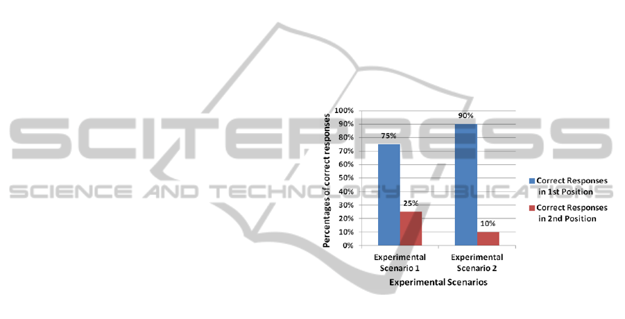
About the quality and correctness of the
recommendations made by RecRoute, participants
were asked whether the route indicated in the first
position of the list suited their needs and if the most
frequent of this list would be chosen. The percentage
of correct answers for the routes that appear in the
first position of the ranking was 75% for the
experimental scenario 1 and 90% for the second
scenario.
This difference might be related to the lower
amount of routes for scenario 2. In other cases the
route chosen by the participants was listed as the
second option and was chosen by the participants
because of the shorter distance to be traveled on foot
in relation to the first.
The routes suggested by RecRoute after the 2nd
option were not chosen by the participants at any
time. Thus, the routes chosen were always in the 1st
or 2nd positions of the list. Figure 8 illustrates the
percentage of correct responses in each experimental
scenario.
Figure 8: Correct Responses X Experimental Scenarios.
Some improvements were proposed by the
participants, as follows:
1. Adapt the interface for the visually impaired.
The inclusion of audible and vibrating alerts could
be a good alternative, as well as voice recognition;
2. Include other information that could influence
the ordering of routes and preferences of users.
Some information suggested were how full the bus
is, hazard risk along routes, bus stops and also where
to get in and to get out the bus and bus exchange;
3. Consider the context of the user to display the
path to be traveled on foot, showing paths with
greater accessibility in case of wheelchair and
visually impaired users;
4. Send clue when the bus is approaching places
that might require user action, e.g., boarding.
6 RELATED WORK
In the literature one can find many studies in the
field of ITS and UIS, but only some of them make
use of recommendation and/or display of public
ICEIS2014-16thInternationalConferenceonEnterpriseInformationSystems
364
transportation routes by bus.
In this section, we analyzed some studies found
that exploit recommender systems and/or display
routes to users, and that are thus related to the
RecRoute
In order to facilitate the analysis of the related
work we adopt some criteria for comparison,
described below:
Use of Contextual Information: The use of
dynamic, static and inferred contextual data and
their interactions enable the application to adapt to a
given situation or provide more relevant services;
Communication Interface with Users: The
communication interface between recommender
systems and their users can be a very important
factor to the effectiveness of the system. Some of
these systems allow access from anywhere and in
many ways, allowing users to have real-time
information, adapted to the dynamics of transit;
User Preferences: For recommender systems,
user preferences are key to providing more
personalized and adapted to the same information;
Users’ History of Usage: The historical usage
data of users can generate useful information for
recommendation system, because through them we
can infer important contextual data, such as
preferences for using the system and thus provide
more relevant recommendations;
Field of Use Only for Public Transportation
by Bus: this criterion evaluated whether the
application is directed only to public transport by
bus.
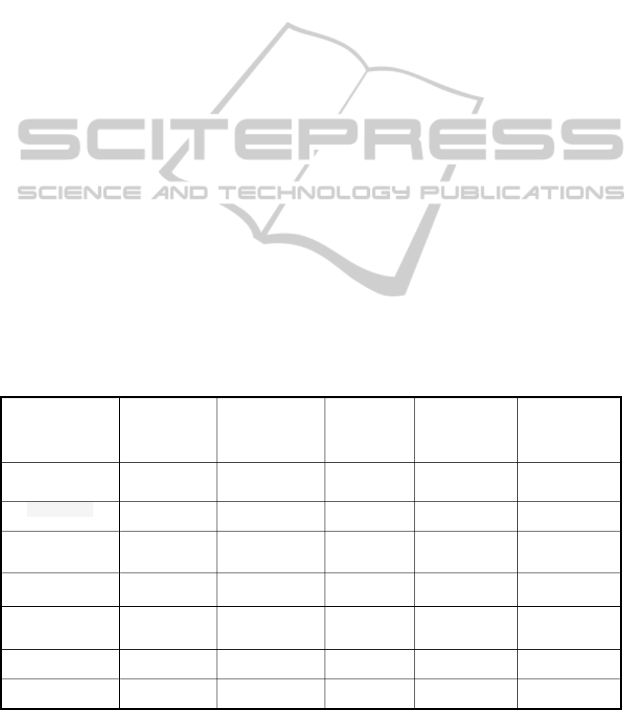
Table 2 shows some studies, analyzing them
according to the criteria above.
We observed that, some studies shown in Table 2
are not totally directed to public transportation by
bus and few consider all types of contextual
information (Static, Dynamic and Inferred) when
making suggestions.
It was also possible to note that the vast majority
of them do not incorporate contextual information
about the climate, time and user context, eg,
preferences and historical usage. Thus, we conclude
that these applications provide features not suited to
passengers.
The RecRoute has many interfaces, is totally
directed to public transportation, includes the
capture and processing of dynamic, static and
inferred data of users, traffic and environment, in
order to provide information and bus routes more
realistic and adapted to the real needs of the users of
urban public transport by bus.
7 CONCLUSIONS AND FURTHER
WORK
Currently, Intelligent Transportation Systems turned
into a very viable and attractive alternative to solve
overcome challenges in the transportation of the
large cities. This evolution is partly due to the
accelerated growth of Information and
Communication Technologies.
Table 2: Comparing the Related Work.
Studies / Criteria
Use of
contextual
information
Communication
interface with
users
User
preferences
Histor
y
of use of
the user
Field of use onl
y
for public
transportation
by bus
OneBusAway
(Ferris et. al., 2009)
Static, Dynamic
and Inferred
Mobile, Web e SMS No No Yes
Bus Catcher
(Bertolotto et. al., 2002)
Static and
Dynamic
Mobile Partly No Yes
Traffic Information
System
(Hoar, 2010)
Static and
Dynamic
Mobile e Web No No Yes
PECITAS
(Tumas and Ricci, 2009)
Static Mobile Partly No No
ANTARES
(Bastos and Jaques,
2010)
Static Web No No Yes
UbibusRoute
(Lima et al., 2012)
Static and
Dynamic
Mobile Partly No Yes
RecRoute
Static, Dynamic
and Inferred
Mobile e Web Yes Yes Yes
RecRoute-ABusRouteRecommendationSystemBasedonUsers'ContextualInformation
365

This development contributes to the increasing
use of computer systems in almost all areas of
human activity. Thus, there is a rising demand for
dynamic, context-sensitive systems. The use of this
type of application in providing information to users
of urban public transport can provide greater
attraction and loyalty to the service.
This work has presented the RecRoute route
recommendation system for users of public
transportation by bus, able to process static and
dynamic contextual information, of the users, bus
lines, climate, time and traffic, providing more
fitting recommendation for the passengers.
This solution differs from other related work by
the use of dynamic contextual information from
various sources by using different devices to enable
ubiquitous and context sensitive use being directed
to public transportation passengers. RecRoute is
integrated to the Ubibus project and is one of its
applications.
Future works are related to the suggestions made
by participants of the experiment and more
experimentations, aiming the improvement of
RecRoute as follows: develop versions for other
operating systems of mobile devices, in addition to
Android, such as IOS and Windows; calibrate the
importance of contextual information used by the
application; and evaluate other algorithms that can
improve the recommendations provided.
REFERENCES
Adomavicius, G., Tuzhilin, A., 2008. Context-Aware
Recommender Systems. In Conference on
Recommender Systems, pp. 335-336.
Baltrunas, L., 2008. Exploiting Contextual Information in
Recommender Systems. In ACM Conference on
Recommender Systems, pp. 295-298.
Baltrunas, L., 2011. Context-Aware Collaborative
Filtering Recommender Systems. 172 f. Tese (Phd.
Thesis in Computer Science). University of Bolzano.
Bolzano, Italy.
Bastos, R., Jaques, P., 2010. Antares: Um sistema web de
consulta de rotas de ônibus como serviço público.
Revista Brasileira de Computação Aplicada, vol. 2,
pp. 41-56.
Bertolotto, M., O’Hare, G., Strahan, R., Brophy, A.,
Martin, A., McLoughlin, E., 2002. Bus catcher: a
context sensitive prototype system for public
transportation users. In 2th International Workshop on
Web and Wireless Geographical Information Systems
(W2GIS), Singapore, pp. 64-72.
Brézillon, P., 1999. Context in Artificial Intelligence: IA
Survey of the Literature. Computer & Artificial
Intelligence 18, pp. 321-340.
Chorianopoulos, K., 2008. Personalized and mobile digital
TV applications. Multimedia Tools and Applications.
In Kluwer Academic Publishers, v.35, n.2, pp. 1-10.
Cutolo, F., 2003. Diretrizes para sistema de informação ao
usuário. In 3th Seminário Internacional PROMOTEO,
Porto Alegre, RS, Brazil.
Ferris, B., Watkins, K., Borning, A., 2009. Onebusaway:
A Transit Traveller Information System. In Mobicase.
San Diego, USA, pp. 92-106.
Friedman, D., 1997. Machine Learning 29, pp. 131-163.
Gómez, A., Diaz, G., Bousetta, K., 2009. ITS Forecast:
GIS Integration with Active Sensory System. In
Information Infrastructure Symposium, pp. 1-6.
Hoar, R., 2010. A personalized web based public transit
information system with user feedback. In 13th
International IEEE Conference on Intelligent
Transportation Systems (ITSC), Ilha da Madeira,
Portugal, pp. 1807-1812.
Lima, V., Magalhães, F., Tito, A. O., Santos, R., Ristar,
A., Santos, L., Vieira, V., Salgado, A. C, 2012.
UbibusRoute : Um Sistema de Identificação e
Sugestão de Rotas de Ônibus Baseado em Informações
de Redes Sociais. In 8th Simpósio Brasileiro de
Sistemas de Informação, São Paulo, Brazil. pp. 516-
527.
Mcculloch, W. S., Pitts, W., 1943. A Logical Calculus of
the Ideas Immanent in Nervous Activity. Bulletin of
Mathematical Biophysics, n.5, p.115-133.
Pilon, J. A., 2009. Sistema de Informação ao Usuário do
Transporte Coletivo por Ônibus na Cidade de Vitória-
ES, Universidade Tecnológica Federal do Paraná –
Ponta Grossa-PR, Brazil.
Quinlan, R., 1993. C4.5: Programs for Machine Learning,
Morgan Kaufmann Publishers, San Mateo, USA.
Sussman, J., 2005. Perspectives on Intelligent
Transportation Systems. New York, USA: Springer.
Tumas, G., Ricci, F., 2009. Personalized mobile city
transport advisory system. In Information and
Communication Technologies in Tourism, Amsterdam,
Nestherlands, pp. 173-183.
Vieira, V., Tedesco, P., Salgado, A. C., 2009. Modelos e
Processos para o Desenvolvimento de Sistemas
Sensíveis ao Contexto. Jornadas de Atualização em
Informática. Porto Alegre, RS, Brazil, pp. 381-431.
Vieira, V., Caldas, L., Salgado, A. C., 2011. Towards an
Ubiquitous and Context Sensitive Public
Transportation System. In 4th International
Conference on Ubi-media Computing, São Paulo, SP,
Brazil, pp 174-179.
Waikato, 2010. Weka 3 – Machine Learning Software in
Java. URL: http://www.cs.waikato.ac.nz/ml/weka.
Zhang, J., Wang, F., Wang, K., Lin, W., Xu, X., Chen, C.,
2011. Data-Driven Intelligent Transportation Systems:
A Survey. IEEE Transactions on Intelligent
Transportation Systems, pp. 1624-1639.
ICEIS2014-16thInternationalConferenceonEnterpriseInformationSystems
366
