
3D Geological Modeling in Northern Dandong, Liaoning Province,
China
Jinxin He, Linfu Xue, Yunliang Yu, Xiaoliang Lei and Xiaojun Liang
College of Earth Sciences, Jilin University, Changchun 130061 P.R. China
jxhe@ymail.com
Keywords: Deep Underground, 3D Geological Modeling, Northern Dandong.
Abstract: With the resources and environmental problem, population problem, the whole society of energy and mineral
resources demand more and more high, but with the resource of the earth's surface over the years of mining,
the reserves has far lower. On the surface of the earth to find ore has become more and more difficult, the
deep underground to find ore more and more and more attention by domestic and foreign researchers. During
the recent years, in the aspects of 3D geological modeling research results more and more, geological
information expression and record gradually by 2D conversion for 3D, so reliable and effective 3D geological
modeling method research become an important trend. Liaodong region is China's important metallogenic
belt in the study area at the mouth of the grass - Tongyuan synclinorium famous Maoling gold, lead and zinc
ore and coal. The research of deep geological structure in this area is good for studying the spatial distribution
of underground deep geological body, and puts forward the corresponding deep metallogenic
regularity. Through using the gravity and magnetic inversion method to the study area underground deep
geological structure of understanding, on the basis of this, using block modeling method, a 3D geological
model is established, finally in multiple aspects of structure, rock and the formation of underground deep
metallogenic regularity were analyzed.
1 INTRODUCTION
Dandong City, Liaoning Province, east and
Democratic People's Republic of Sinuiju across the
river, the geographical coordinates of longitude 124 °
23 ', latitude 40 ° 07'. Maximum horizontal distance
of 96 km, maximum longitudinal distance of 160 km,
120 km long coastline. Ideally, the annual average
temperature of 9 ℃, is one of the livable city. Area
high-speed railway, airport, port is developed, which
also makes it the Northeast region and an important
logistics hub in Northeast Asia. Extensive forest
cover in the region, rich in resources, has an important
ridge of gold mining and boron cat. The area is
located in one of the 12 significant mineralized zones,
is one of the key areas of mineral research, after years
of research which is located on the surface or the
surface of shallow mineral has been fundamental
discoveries, but in the area of minerals deep
underground the occurrence of still has great
potential. So the study area deep underground has
been paid more and more attentions.
2 DANDONG INCREASE
REGIONAL GEOLOGICAL
MAPPING
THREE-DIMENSIONAL MAPS
AND MAPPING PROCESS
2.1 The Study Area Tectonic Position
Liaoji rift mainly in eastern and southern Jilin
Province, Liaoning Province, located in Longgang
rangrim block and between blocks (Figure 2.2). Liaoji
rift within the development of a thick Proterozoic
volcanic - sedimentary rocks, in this study area is
mainly Liaohe Group, formed cap era 1700Ma, the
lower limit is 2200-2500Ma. Mainly grass estuary -
Tongyuanpu into south and north Liaohe Group
Liaohe Group, North Liaohe Group mainly develops
and nappe tectonic lineament, South Liaohe Group
fold structures are developed.
A large area of the study area exposed
Paleoproterozoic Liaohe Group in the study area
north east Neoproterozoic unconformably overlies
440
440
He J., Xue L., Lei X., Yu Y. and Liang X.
3D Geological Modeling in Northern Dandong, Liaoning Province, China.
DOI: 10.5220/0006028104400442
In Proceedings of the Information Science and Management Engineering III (ISME 2015), pages 440-442
ISBN: 978-989-758-163-2
Copyright
c
2015 by SCITEPRESS – Science and Technology Publications, Lda. All rights reserved
the Liaohe Group. Liaoyang web junction with
Cambrian small area distribution and Ordovician,
research and development area in the northeast corner
area of Jurassic, near the eastern Mesozoic Komine
Caohekou distribution group.
2.2 Three-dimensional Modeling
Process
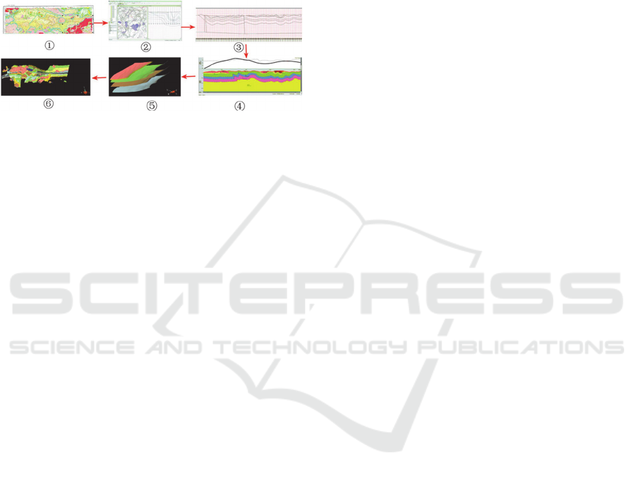
① Block Modeling② cutting section③ sectional drawing
④ inversion profiles⑤ block modeling⑥ block integration
Figure 1: Three-dimensional geological modeling process.
(1) Building Blocks Divided.
Divide principles: 1. if the block by the unconformity
traps can be divided directly; 2. if the block is large or
unconformity trap does not completely block is not
conducive to the 3D modeling, can be assisted by
adding reasonable line to complete; 3. If the presence
of the smaller rock invasion may temporarily without
treatment, in the post-processing (gravity and
magnetic inversion) in adding.
Object of study: 1. strata blocks, it is the focus of
research, including analysis of a variety of different
geological formations; 2. rock blocks, including
primary and secondary and eruption of magma body
is different; 3. fracture, including production faults.
like many other relations between geological factors
and fracture.
(2) Block Cutting Section.
Profile types: 1. a trunk inversion profile,
characterized by: setting can be cross-sectional
unlimited, cross-block research, geophysical and
other data needed to control the accuracy of the entire
area of study, the control link between blocks; 2.
Block control inversion profile, characterized in that:
setting can be cross-sectional analysis of unlimited,
geophysical and other information required in a single
block, three-dimensional modeling of the control and
finesse; 3. geologic modeling profile characterized. 4.
Set the cross section does not cross, to be the main
reference inversion sectional profile, forming a three-
dimensional model.
(3) Synthesis Constraints Subsurface Geological
Inference and Interpretation.
Various studies show that existing single technology
is difficult to directly understand the deep
underground, the joint inversion using gravity and
magnetic profiles implementation constraints deep
geological situation in the present study. Concrete
action is in reference rock samples on the basis of
physical properties (density and magnetic
susceptibility), complete inversion of the trunk
section in Geosoft software, determine the accurate
formation, rock, faults, folds spatial distribution
situation.
(4) Three-dimensional Geological Modeling.
The realization of three-dimensional geological
model adopted in GOCAD eventually generate, with
the gradual improvement IGeoMod software, which
sought to develop a three-dimensional function also
has tended to improve, and then in IGeoMod achieve
three-dimensional visualization can between.
(5) The model’s Modification and Integration.
By completing the trunk inversion profile can well
understand the deep geological structure of the entire
area through which to understand and realize the
connection between the block integration.
3 CONCLUSIONS
Based on the northern Dandong city’s very important
tectonic TongYuanPu - CaoHeKou Synclinorium
region, the deep geological structure, geological
modeling and deep metallogenic regularity region
have a preliminary understanding. Final Thoughts by
block modeling complete geological modeling of the
area.
(1) Liaohe Group in the region exposed a major
stratigraphic units on which the development of a
large number of folds, the lower boundary of Liaohe
Group recognize the basic geological its deepest
estuary should be on grass - tongyuanpu Complex
Syncline, a depth of about 5900m By region of the
gravity and magnetic data analysis and inversion, it
confirms the group's bottom boundary Liaohe basic
core of the syncline, depth of about 6000m, in line
with the basic geological facts. It can also reflect the
gravity and magnetic inversion can accurately reflect
the deep underground geological structure, gravity
and magnetic inversion provides an important tool for
the analysis of deep underground geological
formation.
(2) In the course of the three-dimensional modeling
of the region, for the special geological structure
(folding and fault development) in the region, using
block modeling. Model was done well in the area of
3D Geological Modeling in Northern Dandong, Liaoning Province, China
441
3D Geological Modeling in Northern Dandong, Liaoning Province, China
441

three-dimensional geological modeling, the ways to
simplify the modeling process, to achieve a
geological - geophysical data management, block
(unit) management, cutting section, section
management, 3D geological object generation, export
geophysical models.
(3) On the basis of the geological structure in the area
of deep analysis, the deep mineralization area got a
better understanding. First, the structure ore control
factors play a crucial role in the mineralization
process, the general area of mineralization in the
region are located in anticline core unit, part of the ore
deposits in cracks in the fault zone, in such a
configuration environment with conducive to
migration and enrichment of ore-forming elements.
Second, it features more magmatism presence around
the amount of deposit, to deposit the necessary heat
in the formation process. Finally, rock ore-controlling
role in the region is also obvious a lot of gold deposit
and other types of Pb-Zn occur in the bed and cover
Dashiqiao county groups.
ACKNOWLEDGEMENTS
This work was supported by National 973 Basic
Research Program of China (2015CB453000), Jilin
Province Foundation of Applicable Sciences
(20130102033JC) and Jilin Province Foundation of
Youngster Scientists (20130522106JH). We also
thank the anonymous reviewers for their helpful
suggestions.
REFERENCES
Ling Yonghong, Huang Xiaowei, 2009. The 3D geological
modeling technology and its realization in oilfield.
Computer Engineering, pp. 96-98
Liu Bing, 2012. The application of 3D geological
technology in geological. Chinese petroleum and
chemical standard and quality pp. 225-227.
Liu Jiyou, 2004. The research and application of 3D
geological body.Daqing Petroleum Institute pp. 16-18.
Ling Yonghong, Huang Xiaowei, 2009, Oil of 3D
geological modeling technology and software
implementation. Computer Engineering pp. 32-36.
Dong Hui, 2003. The geological body research on 3d
visualization. Central South University pp. 7-18.
LiQingyuan, Zhang Liyun, Wei Zhanying, Sun Liming,
2013. The 3D geological software research on the
develop Journals of Geology pp. 55-57.
HanJianguo, Guo Dazhi, 1992. The storage of octree and
the information of ore body.Journal of Surveying and
mapping pp. 33-35.
Tang Zesheng, 1991. The visualization of the data of 3D
Computer Engineering pp. 215-274.
XUJiali, 2004. The research of the visual data on the oil
exploration and develop Zhejiang University pp. 16-18.
M. Wan, A. Kauffmann Bryson, 1999. Opimized
interpolation for volume ray casting Vol. 11-24.
Erich Grmma: Design Pattern, 2007, Elements of Reusable
Object-Oriented software Addison-Wesley Longman
Publishingpp. 1-11.
Richard. S. Wright, Benjamin Lipchak, Nicolas Haemel,
2007. OpenGL Superbible Fourch Edition Sams
Indianapolis pp. 24-28.
Mat RuzinoorChe, Mahmud AhmadRodzi, 2009. Online
3D terrain visualization: A comparison of three
different GIS software Quality Engineering pp. 483-
487.
Alan Petzet, 2002. Gains from Visualization Computer
science pp. 17-33.
Geoffrey A. Dorn, 2002. Computing and Visualization, The
Leading Edge, pp. 580-586.
ISME 2015 - Information Science and Management Engineering III
442
ISME 2015 - International Conference on Information System and Management Engineering
442
