
GIS DAY ACTIVITIES AND THE ConTIG PROJECT
Using Geographical Information Technologies in Middle and High School
Madalena Mota and Marco Painho
Instituto Superior de Estatística e Gestão de Informação, Universidade Nova de Lisboa
Campus de Campolide,1070-312 Lisbon, Portugal
Keywords: ConTIG, GIS Day, Geographical Information Technologies (GIT), Learning experiences.
Abstract: In November 2008, ISEGI-UNL (Instituto Superior de Estatística e Gestão de Informação – Universidade
Nova de Lisboa) hosted a GIS Day inviting seven secondary schools to use and experience Geographical
Information Systems (GIS) and Global Positioning System (GPS) technology. Sixteen teachers and about
one hundred and twenty students from 7th to 12th grades were able to try and learn about Geographical
Information Technologies (GIT). This event is one of the activities that are being developed by ISEGI-UNL
in a partnership with ESRI Portugal and two Portuguese high schools since 2007. During the 2007/2008
school year, ISEGI-UNL had a grant from the Portuguese program “Ciência Viva” (from the National
Agency for the Scientific and Technological Culture) to develop several learning experiences with the aim
of promoting a learning process centred on experience, in which the focus is given by the use of geographic
information technologies (the ConTIG project). During the current year (2008/2009), the project continues,
but open to any school that wants to try the learning experiences (that are available online) and also share
their own experiences. GIS Day is one of the ConTIG events. Other activities will also include courses for
teachers to learn how to use the technologies and practical activities with students in their schools.
1 INTRODUCTION
Since 2007, the Instituto Superior de Estatística e
Gestão de Informação from the New University of
Lisbon, (ISEGI-UNL) is coordinating a Project
(named ConTIG) that aims to promote experimental
teaching in basic and secondary education through
the use of Geographical Information Technologies
(GIT). The project’s general goals are the following:
• Awareness to the importance of geographic
information in daily life,
• Develop spatial analysis skills in students,
• Develop research and group work skills,
• Develop critical sense about spatial planning,
• Create maps for various purposes,
• Share these learning experiences and all the
materials,
• Disclose the project results and some of the
students work in seminars and in teachers
meetings.
Among the different activities of the ConTIG
project are the GIS Day events. These were held in
ISEGI-UNL’s campus in order to get teachers and
students of non university levels in contact with GIT
and with people that use them daily. It is also
important to show how GIT have real-world
applications and how important they are to our
every-day activities.
Other activities of the ConTIG project are
teachers training, production of educational
materials to use in the classroom, preparing field
trips with the aid of GPS and ArcPad®, supporting
teachers in different activities in and outside the
classroom.
2 THE ConTIG PROJECT
The ConTIG project, supported by the National
Agency for Scientific and Technological Culture
(“Ciência Viva” program) until 2008, was carried
out by ISEGI-UNL and three partners: ESRI-
Portugal and two schools in the Lisbon area (Escola
Secundária com 3ºCiclo do Ensino Básico de Pinhal
Novo and Escola Secundária Maria Amália Vaz de
Carvalho, in Lisbon). Two other schools (Escola
Secundária de Palmela and Escola Profissional de
242
Mota M. and Painho M. (2009).
GIS DAY ACTIVITIES AND THE ConTIG PROJECT - Using Geographical Information Technologies in Middle and High School.
In Proceedings of the First International Conference on Computer Supported Education, pages 241-246
DOI: 10.5220/0001973602410246
Copyright
c
SciTePress
Ciências Cartográficas in Lisbon) also participated
in some activities, developing exercises in the
classroom, using Geographical Information Systems
(GIS) to create maps and carrying out other
assignments for different classes.
One of the goals of the ConTIG project is to
help teachers organize the curricula according to the
guiding principles of the Portuguese standards and
national curricula that, among other things, state that
one must use a diversity of methods, activities and
strategies in education, especially using information
and communication technologies, to promote skill
development in a lifelong learning perspective
(MINISTÉRIO DA EDUCAÇÃO, 2001).
The ConTIG activities involved students from
different levels and teachers from different subjects:
Geography, Biology, Geology, Physics, Chemistry,
Economics, Philosophy, Computers, Project and
specific subjects from professional courses in
Gardening and Tourist Technician. About 120
students from the 7
th
to the 12
th
grades were involved
in the project, during 2007/2008.
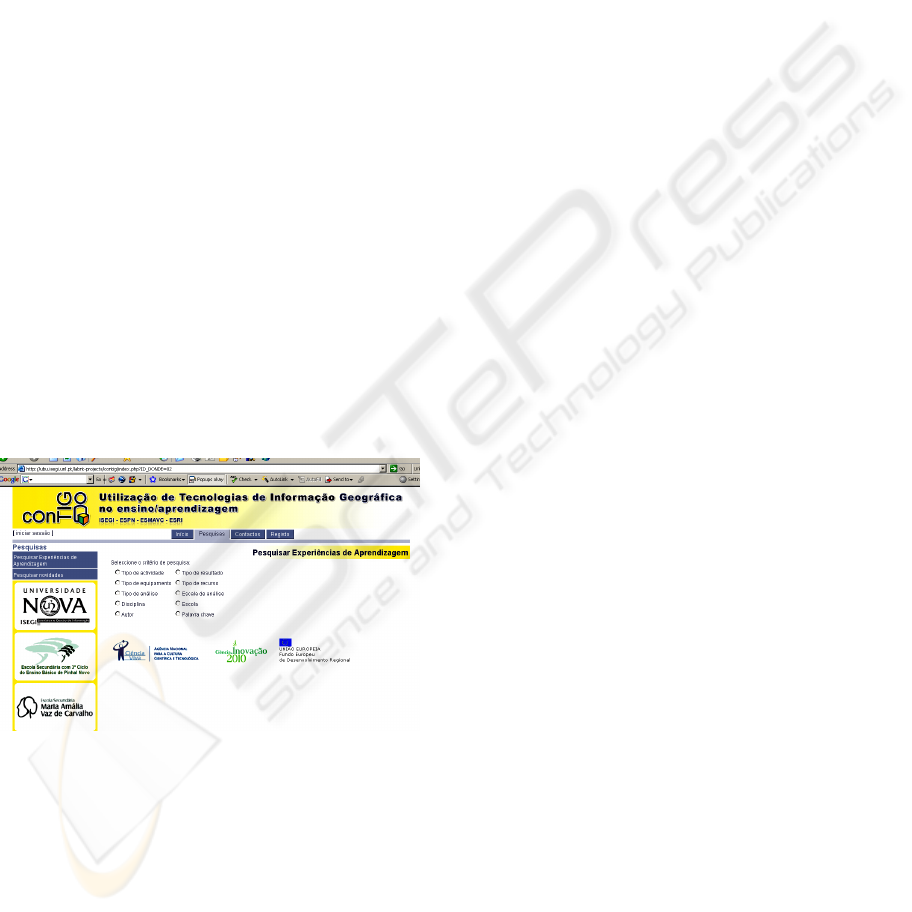
The ConTIG project also created a web page
(http://ubu.isegi.unl.pt/labnt-projects/contig) that
provides free access to all the materials produced,
such as the learning experiences with the
geographical data, teacher and student’s guidelines
and also the results (such as maps and reports)
produced by the students (Figure 1).
Figure 1: The ConTIG web page.
In this web page it is also possible to read all the
news about the activities, the seminars on which the
project is being presented and a web-GIS platform in
which some of the learning experiences can be
carried out. The learning experiences can include
classroom activities, field trips planning, reports,
simple research tasks, among others.
By the end of the “Ciência Viva” program in
July 2008, the balance was very:
• Two workshops for teachers were completed;
• Several teachers created learning experiences
and tried them with their students
successfully. These learning experiences are
available at the ConTIG’s web page with free
access to all the materials (including
geographical data, tutorials etc.).
• The web page works as a tool to help
teachers and students use the technology
(ISEGI-UNL was responsible for producing
tutorials) and also as a dialog platform,
where registered users can publish news and
materials to share;
• Some equipment (including PDA, GPS and
GIS software) were acquired for both schools
that were partners on the project;
• The project was presented in several GIS and
education meetings, in Portugal and in the
USA.
In 2008-2009, although there is no longer
funding from the “Ciência Viva” program, the
ConTIG project continues to carry out its activities
with the support of a high school teacher on a
sabbatical license. The sabbatical allows this teacher
to be fully dedicated to the project, maintaining the
information on the portal up to date, organizing the
activities, producing materials and data to be used in
classes, following up the activities in different
schools, supporting and training teachers, etc. This
work, supported by ISEGI-UNL (who is still
coordinating the ConTIG project), is very important
to keep teachers from different schools in contact
with each other and to maintain their involvement in
the ConTIG activities, by supporting them when
needed.
2.1 GIS Day (2007 and 2008)
ISEGI-UNL has experience in organizing GIS Days
since 1999 and the high school teacher responsible
for the project is also organizing these events since
2005.
GIS Day is a world wide event that is integrated
in the Geography Awareness Week, sponsored by
the National Geographic Society. This week aims to
promote “geographic literacy in schools,
communities and organizations, with focus on the
education of children. GIS Day is held on the
Wednesday during Geography Awareness Week”
(ESRI, 2008). GIS Day is sponsored by several
organizations (including ESRI, Association of
American Geographers, the United States
Geological Survey, the Library of Congress, Hewlett
GIS DAY ACTIVITIES AND THE ConTIG PROJECT - Using Geographical Information Technologies in Middle and
High School
243
Packard, etc.), and provides an international forum
for GIS users. GIS Day is important to demonstrate
real-world applications of these technologies.
According to the GIS Day sponsors (ESRI,
2008), participating in a GIS Day will benefit
students in different ways:
• Exposing students to cutting edge technology;
• Helping students understand real-world
problems using data analysis;
• Developing appropriate curriculum that will
keep students' interest;
• Preparing and point students toward GIS jobs
and career options;
• Sharing information across multiple disciplines
and promoting a holistic approach to learning;
• Building alliances with other schools and
organizations.
One of the first activities of the ConTIG project
was the celebration of GIS Day in the ISEGI-UNL
campus in November 14
th
2007, showing how GIT
works and some of its possibilities. Students and
teachers from both partner schools were present to
meet each other and got to do a hands-on activity
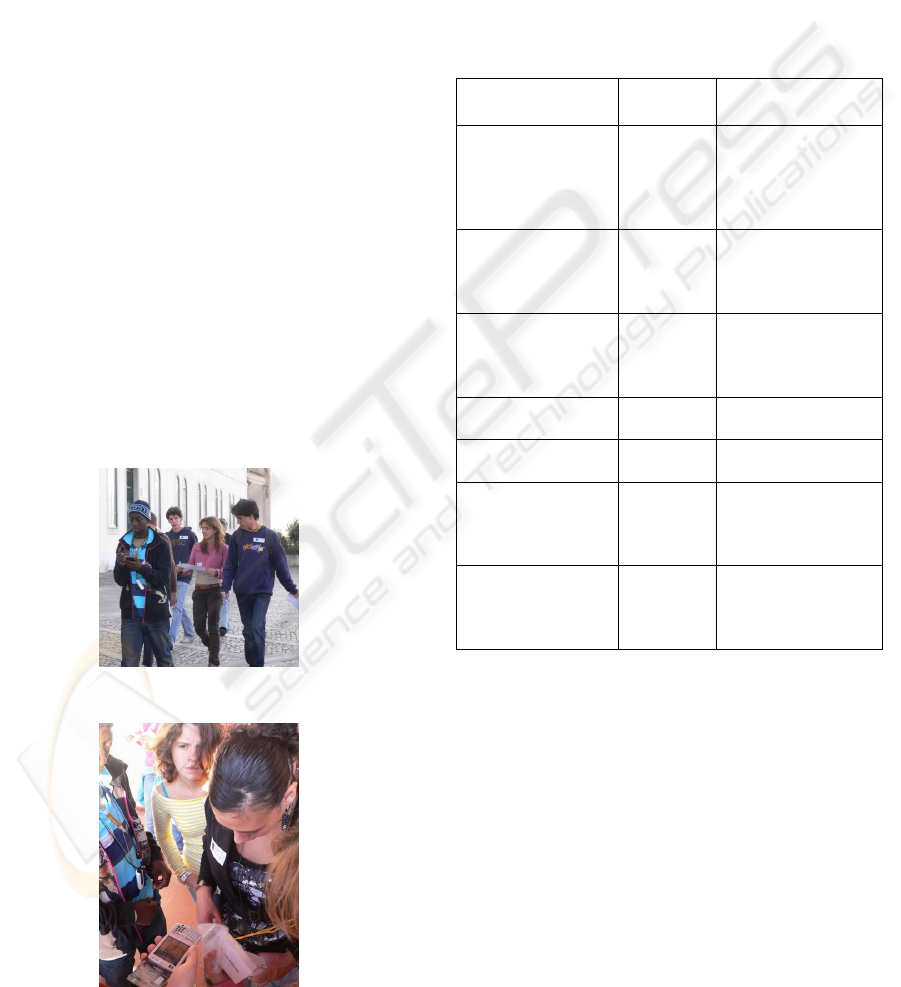
with GPS and GIS technologies. The activity
consisted on a Geopaper on the ISEGI-UNL
campus. The students had to find clues with the help
of a GPS receiver and ESRI’s ArcPad® technology
(Figure 2 and Figure 3).
Figure 2: Geopaper activity during GIS Day2007.
Figure 3: Learning to use ArcPAD® during GIS Day2007.
This event is an opportunity to help expose
students to GIT (including GIS and GPS), educate
other teachers and also build alliances between
schools and organizations. Students benefit from
GIS Day because they have the opportunity to
contact directly with the technology and with
instructors and professionals that can help them.
In November 19
th
2008, ISEGI-UNL organized a
similar activity. This year, 123 students and 16
teachers from seven different schools attended the
event (Table 1):
Table 1 – GIS Day 2008 participants at ISEGI-UNL.
School
Teachers
present
Participating
students
Centro de
Educação e
Desenvolvimento
de Maria Pia (from
Lisbon’s Casa Pia)
4 21 (7th grade)
Escola
Secundária/3
Seomara da Costa
Primo
3 21 (8th grade)
Escola EB2,3 com
Secundário de
Santo António
(Barreiro)
2 19 (9th grade)
Escola EB Cidade
de Castelo Branco
3 20 (9th grade)
Escola Secundária
da Amadora
1 14 (10th grade)
Escola Secundária
Maria Amália Vaz
de Carvalho
(Lisbon)
1 20 (11th grade)
Escola Secundária
com 3º Ciclo do
Ensino Básico de
Pinhal Novo
2 8 (12th grade)
During the day, teachers and other ISEGI-UNL’s
collaborators were available to help the students. But
there was no helping on finding the locations.
Almost everyone was able to successfully finish the
assignments. But it was also noticeable that some
students still have problems with orientation and
finding their way on the map. It was also noticed
that there is some confusion between Latitude and
Longitude. The most common error was North and
South Longitudes and East and West Latitudes. One
of the teachers said the experience was useful for her
to realize she needs to do more practical activities to
consolidate certain basic spatial skills.
The activities, similar to the ones in the previous
year, were carried out in four shifts: 10H, 12H, 14H
CSEDU 2009 - International Conference on Computer Supported Education
244
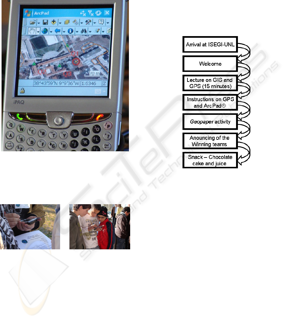
and 16H. In each shift, there were seven teams of
four or five students that received some information
about GIS, GPS and how to use the ArcPad
®
(Figure 4).
Figure 4: ArcPAD® with the information for the GIS
Day2008 Geopaper.
Then, each team had to search for places and
answer a geographical question in each place (Figure
5 and Figure 6).
Figure 5: ArcPAD® and
question sheet for the GIS
Day2008 Geopaper.
Figure 6: Using ArcPAD®
on GIS Day2008.
The activity consisted on examining a map
placed on the GPS receiver equipped with ArcPad®.
The map represented ISEGI-UNL’s campus and had
three points indicating the locations to search. Each
group had three different points. The students had to
use their orientation abilities and also their map
reading skills to get to the points. At each location
they had to determine the geographical coordinates
and answer a simple question. These questions
appealed to their orientation skills and were also
useful to determine if they were at the right place. It
could be a question about something written on a
sign or a specific orientation of landmarks.
Coming back, as quickly as possible with the
right answers, there was a winning team in each
shift. After presenting the results and giving out the
prizes and some gifts to all, there was time for a
snack. Figure 7 shows the sequence of the activities
of each shift.
Figure 7: GIS Day 2008 activities.
A few weeks after GIS Day, a simple opinion
questionnaire was made to the participants. Teachers
and students representing grades 9
th
to 12
th
answered. The results show that most students and
teachers enjoyed the activity and would like to
repeat it or even have a similar one at their schools.
Students had the perception that the activity was
useful for learning new things like using new
technology (on a scale of 1 to 4, the average answer
was 3) and they also think the activity contributed to
understand better Geography subjects (on a scale of
1 to 4, the average answer was 2,7). As for teachers,
they all responded that they would like to organize
more activities of this kind and said that GIS-Day
was an important way of detecting missing skills in
students, giving them an indication of what subjects
need to be enhanced in the classroom.
These results showed us that it is important to pursue
investigating in this field to identify the real impacts
that practical orientation activities using GPS and
GIS technologies have in learning. We can certainly
conclude that these are motivating activities.
GIS DAY ACTIVITIES AND THE ConTIG PROJECT - Using Geographical Information Technologies in Middle and
High School
245

2.2 Teachers Training
“Geographic information systems (GIS) technology
and methods have transformed decision-making in
society--in government, academia, and industry.
Some educators consider GIS to be one of the most
promising means for implementing educational
reform” (KERSKI, 2003). In 2004, Steven Palladino
stated that the use of GIS in secondary levels is not
that important to create new knowledge, but it
“should allow for a more sophisticated form of
enquiry in secondary school geography (and in other
subjects). This enhanced ability to stimulate critical
thinking and problem solving is one of the great
promotions for the use of GIS in the secondary
schools” (PALLADINO, 2004).
Teachers can use technology in the classroom as
a way of getting the students to develop better
spatial skills. GIS software can help educators and
students answer community and global questions.
GIT can be a good tool to help understand the world
around us. It promotes critical thinking and solving
problem skills in students. It has been pointed by the
report from the American National Research
Council (NATIONAL RESEARCH COUNCIL,
2006) that it is important to install spatial thinking
skills across subjects and into the lives of learners of
all ages. GIS can help doing this because not only it
can help develop spatial skills, but also can promote
interdisciplinary teaching. It’s possible to create
learning experiences with GIS that involve different
subjects. GIS can manage a great deal of information
and link together different maps and data.
To get students to use GIT, it’s important that the
teachers can use them well. So, one of the priorities
of the ConTIG project is to train teachers not only
on how to operate the computer programs, but also
on showing them how they can develop activities for
the classroom. Workshops and courses were
prepared in order to achieve these goals. Some of the
teachers involved never worked with GIS before so
it is important to begin training by the fundamentals
of GIS knowledge. Most of the teachers that attend
these trainings are Geography teachers and some
already use online resources like Web GIS and
programs like Google Earth in their classroom.
These training sessions were important to lead to the
production of educational materials that are online at
the ConTIG web page.
After the two workshops that occurred in
2007/2008, the ConTIG team is preparing some
specific training in GIS. This will be held in the first
trimester of 2009 to prepare teachers to better use
the GIS technology. This training will be officially
credited by the Scientific and Pedagogic Council for
Continuous Training (official organism that credit
Portuguese teachers for their life long training) and
by the Portuguese Association of Geography
Teachers through the Professor Orlando Ribeiro
Training Center. Geographic inquiry consists on five
steps which are (MALONE et al. 2002):
1- Ask geographic questions
2- Acquire geographic resources
3- Explore geographic data
4- Analyze geographic information
5- Act upon geographic knowledge.
This mode of thinking allows students to think
spatially and investigate with the same methods as
professionals in different areas.
We hope that this training will not only get teachers
to have a better domain of the software, but also
promote ways of teaching in an inquiry based
learning (MOTA, 2005).
2.3 Support Teaching Activities in
Schools
The “Learning to Think Spatially” report
(NATIONAL RESEARCH COUNCIL, 2006) states
that it’s important to have support systems including
curriculum and teacher training. The ConTIG
project is committed to help teachers with their
training but also within the classroom. Some high
school classes were given with more than one
teacher at the time, so that the students can have a
better support of teachers while using the GIS
programs. These classes are supported by the
ConTIG project, that provides someone available to
prepare materials (theoretical and also data sets and
GIS projects) and exercises for the students. The
results of these actions are being positive because
when students use the software for the first time, it’s
important to have more than one teacher to solve
small problems if they occur. The 90 minutes of a
regular class in Portugal, can be better managed and
the students can profit better from having two
teachers there. It’s also important when teachers are
not so at-ease in a computer room and this can occur
if they are not yet very comfortable with the
software (if they are still in training themselves).
The ConTIG team is also available to give
lectures in different schools (to teachers and/or
students) to promote the project, and trying to get
more teachers to participate.
It is also part of the activities planned for
2008/2009, to work with elementary schools. Of
course, in this case, the lessons will be prepared with
CSEDU 2009 - International Conference on Computer Supported Education
246

much simpler software, but the “thinking spatially”
philosophy will still apply. We are eager to try and
see the results.
3 CONCLUSIONS
Due to the advantages (demonstrated through out the
bibliography) of using GIT in the classroom, we
believe the ConTIG project can alter the way people
are teaching Geography and other subjects, bringing
benefits to student’s spatial analysis skills. Different
phenomena, with a common spatial scenario can be
analyzed and explored together. It’s possible to find
patterns and it’s easier to observe relationships
between them. The use of Communication and
Information Technologies (computers in general) is
frequently a motivating factor for students in middle
school and high school levels.
Activities such as GIS Day are fun but are also
important to alert to the importance of Geographical
Information in different contexts. They are a starting
point to get teachers to use Geographic Technologies
(GT) as tools for teaching experimental sciences.
From the questionnaire made to the GIS-Day
participants we conclude that organizing such an
event is not enough to get teachers involved in using
GT in the classroom, but it certainly can be a stating
point. It seems to be an activity that gets teachers
aware of the possibility of doing these kinds of
practical activities and detecting missing skills.
We believe that the technology is not necessary
to acquire orientation skills. However, it can be a
much more appealing way of reaching youngsters
interests. It’s also a good way of getting student’s
attention to the fact that Geography can be helpful
and useful. From the student’s opinions, we learned
that they liked to participate and that they believe
they understand better some Geography subjects.
REFERENCES
Conceição, Alexandre; Matola, Hermínia; Medeiros
Emanuel; Mendes, Tiago; Oliveira, Rafael, 2008,
Análise do Desenvolvimento Sustentável em Portugal
– Uma Abordagem SIG Proposta pelos Alunos da
EPCG, presentation at ESIG.
ESRI, 2008, www.gisday.com
Kerski, Joseph, 2003, The Implementation and
Effectiveness of Geographic Information Systems
Technology and Methods in Secondary Education,
Journal of Geography, 102, nº3,
http://www.josephkerski.com/
Malone, Lyn; Palmer, Anita; Voigt, Christine, 2002,
Mapping Our World: GIS Lessons for Educators,
ESRI, Redlands.
MINISTÉRIO DA EDUCAÇÃO, 2001, Currículo
nacional do ensino básico: competências essenciais,
(Lisbon: Ministério da Educação – Departamento da
Educação Básica).
Mota, Madalena; Pedroso, Rodrigo; Marques, Bruno,
2008, Distribuição Espacial das Residências dos
Alunos do 7ºC da Escola Secundária de Palmela.
Poster presented at ESRI-Portugal User Conference
(EUE08), March 26Th and 27Th, Lisbon.
Mota, Madalena; Painho, Marco; Curvelo, Paula; Vidal,
Óscar, 2008, Science Experimental Teaching Through
the Use of Geographical Information Systems, ESRI
International User Confernce, August 4th to 8th, San
Diego Convention Centre, Califórnia USA,
http://gis.esri.com/library/userconf/proc08/papers/pape
rs/pap_1963.pdf.
Mota, Madalena; Peixoto, Miguel; Painho, Marco;
Curvelo, Paula; Ferreira, Francisco, 2006, ConSIG –
Using GIS in teaching/learning processes, ESRI
International User Conference, August 7th to 11th,
San Diego, California, USA, (Paper nº UC2042),
http://www.isegi.unl.pt/labnt/papers/ESRI_2006_p204
2.pdf.
Mota, Madalena, 2005, Concepção de Curricula em
Análise Espacial para o Terceiro Ciclo do Ensino
Básico, Masters dissertation at ISEGI-UNL (Lisbon)
http://www.isegi.unl.pt/servicos/documentos/TSIG007
.pdf
NATIONAL RESEARCH COUNCIL, 2006, Learning to
Think Spatially: GIS as a Support System in the K-12
Curriculum
Palladino, Steven, 2004, A Role for Geographic
Information Systems in the Secondary Schools: An
Assessment of the Current Status and Future
Possibilities, Thesis submitted in partial satisfaction of
the requirements for the degree of Master of Arts in
Geography, University of California Santa Barbara,
http://www.ncgia.ucsb.edu/~spalladi/thesis/title.html.
GIS DAY ACTIVITIES AND THE ConTIG PROJECT - Using Geographical Information Technologies in Middle and
High School
247
