REALIZATION OF EFFECTIVE DISASTER VICTIM SUPPORT
THROUGH INFORMATION INTEGRATION AND
VISUALIZATION USING GIS
Munenari Inoguchi, Keiko Tamura
Research Center for Natural Hazard and Disaster Recovery, Niigata University, Niigata, Japan
Shigeo Tatsuki
1
, Haruo Hayashi
2
1
Department of Sociology, Doshisha University, Kyoto, Japan
2
Research Center for Disaster Reduction Systems, Disaster Prevention Research Institute, Kyoto University, Kyoto, Japan
Keywords: GIS, Information Integration, Temporary Housings, Long-term Life Recovery, Persons with Special Needs.
Abstract: Disaster victims, who cannot make progress in their life recovery by themselves, need to be supported
generously by local government. However, there is no information management system for the progress of
their life recovery process in order to identify the individual needs of victims. In the first step of this
research, we designed and developed Victims Master Database which stored the situation of progress of
victims’ life recovery process. This master database is developed by the integration of 5 databases; two of
those are Residents’ Ledger and Fixed Asset Tax Rolls which are used in daily routine business, and the
others are databases for granted certification of building damage degree, relief programs management and
public temporary housing management which are constructed after the disaster. In this integration,
however, it is unable to connect together simply because there is no relational key in each database.
Against this issue, we applied GeoWrap method which can connect databases in GIS by the spatial
proximity between pieces of information. In the second step, we developed the information management
system which can ascertain victims’ life recovery status and visualize it in spatial. By using this system,
responders developed common operational pictures of victims’ status, and provide generous support for
victims with special needs effectively.
1 BACKGROUND OF RESEARCH
When risk becomes actualized and a disaster occurs,
the greater the degree of damage due the disaster,
the larger the number of people whose everyday
lives are destroyed, and the longer it takes for those
lives to be reconstructed. In order to realize early
recovery from disasters, it is vital to effectively
support the process of reconstructing the lives of
those affected.
Figure 1 shows the work flow of administrative
support. Within a process of reconstructing those
lives, it is imperative to develop a tool which
implements relief efforts within a comprehensive
framework as well as effectively supporting such a
process.
Carrying out the Building Inspection for Assessment of Building Damages
Constructing Database for the Results of Building Inspection
with Geo-reference
Granting Certification of the Degree of Building Damages to Victims
Insuring Effective and Prompt Service to Victims
based on the Victims’ Master DB
Relief Money
Temporary
housings
Urgent Repair
Demolition of
Damaged
Housings
Disaster Relief
Fund
Public Nursing
Insurance
Property Tax
National Health
Service
Child Care
Relief Programs
Reduced Rates and
Exemption to Payment
Figure 1: Work Flow of Administrative Support.
381
Inoguchi M., Tamura K., Tatsuki S. and Hayashi H. (2010).
REALIZATION OF EFFECTIVE DISASTER VICTIM SUPPORT THROUGH INFORMATION INTEGRATION AND VISUALIZATION USING GIS.
In Proceedings of the Third International Conference on Health Informatics, pages 381-387
DOI: 10.5220/0002693703810387
Copyright
c
SciTePress
2 POTENTIALITY OF VICTIMS
MASTER DATABASE
2.1 Basic Framework
When implementing support for reconstructing the
lives of disaster victims, it is necessary to make a
fundamental decision as to how to allocate the
limited amount of human and material resources
available for disaster relief. The options can be
divided into: 1) allocating support to each disaster
victim in equal measure, 2) allocating support
depending on attributes of victims (e.g. a higher
level of support for the elderly and the poor), and 3)
allocating support depending on the extent of
damage suffered by victim. In order to make a
decision as to which option, or combination of
options, to use, it is necessary to establish an
environment in which information regarding 1)
identity, 2) attributes and 3) extent of damage
suffered (e.g. “destruction”, “severe damage”,
“partial damage”, or “no damage” to residence) for
each victim can be organized and simulations of
allocation of resources can be conducted. Such an
environment will also enable efficient allocation of
resources after such decision has been made.
2.2 Establishment of Victims Master
Database using GIS
In order to establish a basic framework for life
reconstruction support, it is necessary to work
towards creation of a victim register. In this
research, this victim register is named “Victims
Master Database (VMDB)”. In addition to existing
registers, such as the Basic Residents Register and
taxation registers, that contain various necessary
information of citizens for day-to-day civil
administration, it is necessary to establish VMDB
for life reconstruction support.
VMDB is a database that spatially allocates
various information that do not necessarily have
primary keys in common, such as: 1) information
that shows all disaster victims, including those not
originally included in the residents registers for day-
to-day administration but surface in the aftermath, 2)
existing attribute information already held for day-
to-day administration, and 3) extent of damage
caused by the disaster, and integrates information
from spatial proximities between the pieces of
information.
2.3 Use of Victims Master Database
Once VMDB is created and life reconstruction
support efforts are underway in accordance with the
decision made with regards to resource allocation,
disaster victims who have an underlying capability
for independent living will eventually be able to
reconstruct their lives with the help of life
reconstruction support. However, there are also
those for whom support on a macro scale is
insufficient to enable them to reconstruct their lives;
it is therefore necessary to have a system in which
individual circumstances not listed in the basic
information on VMDB are taken into account in
order to concentrate levels of support for such
individuals. In addition, information that has been
consolidated based on such a system is represented
and visualized spatially, thereby allowing planning
of support measures and spatial identification of
victims requiring priority for support, thus
supporting implementation of swift support
measures as shown in Figure 2.
In this research, creation of VMDB is carried out
in partnership with Kashiwazaki City which was
affected by the Niigataken Chuetsu-oki Earthquake.
The situation regarding victim livelihood
reconstruction support in Kashiwazaki is
established, and a realistically achievable VMDB is
created through real-life assessment, leading to a
development of a system capable of effective
information collection and integration, and creation
of a system capable of visualizing such information
spatially.
Victimsin
thesmoothway
toliferecovery
VictimsMaster
Database
(VMDB)
Victimswith
problems
Identify
Geographically
Clarify their
problems
Determine the
best support
programs
Makea
door‐to‐doorvisit
ReportsaboutAll
Victims’Situation
Casework
ProvideIndividual
SupportProgram
GIS
Figure 2: Model for Providing Micro Support.
HEALTHINF 2010 - International Conference on Health Informatics
382

3 CREATION OF VICTIMS
MASTER DATABASE
Kashiwazaki City has a Basic Residents Register
which keeps track of residents for day-to-day
administration. Those who are not shown on the
Basic Residents Register were identified as victims
affected by the disaster by the municipal authority
based on various documents proving that they were
residing in the city at the time of the disaster.
Additionally, there are also tax registers for
managing resident tax and fixed asset tax during
day-to-day administration. In terms of victim
attributes, the income of an affected household can
be determined from the resident tax register, and the
household's home-owning status can be determined
from the fixed asset tax.
In Japan, various types of support are offered
based on the Act on Support for Reconstructing
Livelihoods of Disaster Victims, and these are based
on the level of damage suffered to the homes of the
afflicted. After a disaster, the municipal authorities
conduct damage assessment on every building, and
the level of damage is determined through issue of a
disaster damage certificate with the victim's
agreement.
Granted Certification
of the Degree
of Building Damage
Relief Programs
Management
Residents’ Ledger
Fixed Asset Tax
Rolls
Victim Certification ID
Victim Certification ID
Household ID
Victim Certification ID
⇔ Household ID
Master
Database
Updating
Database
Geo-reference
Public Temporary
Housing Management
Figure 3: Configuration of Victims Master Database.
地番図
家屋課税台帳
住宅地図
被害認定結果
LandRegistryBook
FixedAssetTaxRolls
Residents’Lodger
HousingBoundary
Geo‐Referenceof
theBuildingInspectionResults
IntegrationbyWrapping
WithHousingBoundary
Figure 4: The Framework of GEOWRAP.
The local authorities then provide livelihood
reconstruction benefit payments, temporary housing,
disaster relief public housing and other types of
support to the disaster victims in accordance with
the level of damage suffered. Criteria of eligibility
for each type of support vary; information regarding
recipients of each type of support are collected
individually and managed in the form of registers.
In the case of Kashiwazaki City, a unified
information integration was achieved by merging the
registers used for day-to-day administration as
mentioned above and the registers created after the
earthquake, thereby establishing a register that forms
a basis of VMDB and that can be used to ascertain
individual circumstances of the disaster victims as
shown in Figure 3.
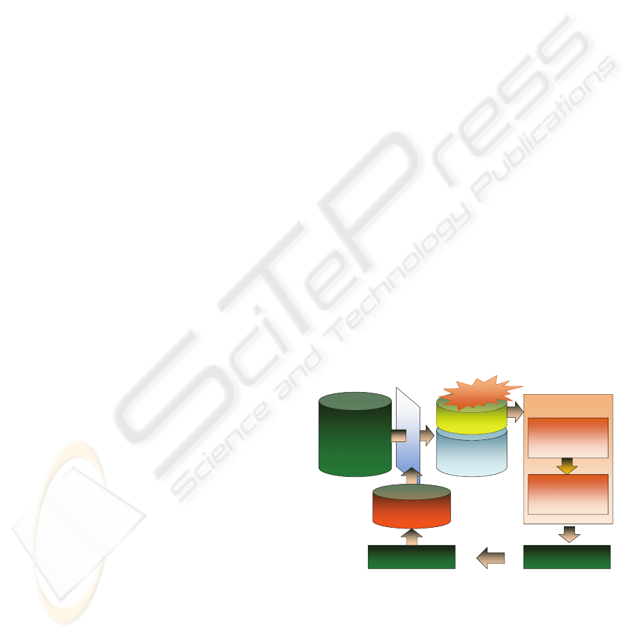
4 NEW VISUALIZATION
TECHNOLOGY WITH GIS
4.1 Establishment of a Spatial
Reference Type VMDB that Uses
GEOWRAP
In Kashiwazaki, each of the registers that support the
VMDB does not have primary keys in common.
Therefore, Yoshitomi et al (2009) conducted
information integration based on a system called
GEOWRAP that uses space for information
integration. In this system, information which do
not have primary keys in common are spatially
allocated, and spatial proximity between pieces of
information is used to integrate information.
Information such as address managed by the
Basic Residents Register, address managed by the
fixed asset tax register, or location of buildings from
the damage certification assessment are allocated in
space as geographical information. Such
information all relate to the residence, and are
basically included in the same house frame. The
various types of information were therefore
integrated using GEOWRAP technology, using the
house frame as the key. Additionally, the various
registers obtained in the course of victim livelihood
reconstruction support are merged to create VMDB.
In this VMDB, the location of the disaster
victim's house or the location of their temporary
accommodation are provided in the form of spatial
information, and all information is managed as
spatial reference-type information.
REALIZATION OF EFFECTIVE DISASTER VICTIM SUPPORT THROUGH INFORMATION INTEGRATION AND
VISUALIZATION USING GIS
383
4.2 Proposal for 3 Layers for
Visualization, Taking into Account
the Viewpoint of Responders
In terms of information visualization in order to
consolidate the process of assessing the situation, the
following three layers were established based on the
requirements on the ground.
1) Overall Tasks Layer
This layer allows a panoramic visualization of the
overall status across the entire area under the
responsibility of the authority. This helps to
implement measures that have a large area-wide
effect across the area under the jurisdiction of the
authority, allowing effective support of a large
number of applicable disaster victims.
2) Segmented Victim Groups Tasks Layer
In this layer, the user sets several conditions for
which information is amalgamated, thereby allowing
segmented groups of victims to be retrieved and
their characteristics visualized. This allows
appropriate measures to be implemented to each of
those segments, resulting in more specific support.
3) Individual Tasks Layer
In this layer, individual circumstances for each
disaster victim are ascertained and visualized on an
individual level. This allows individual needs to be
ascertained and individual support measures to be
devised. Therefore, this layer is one that supports
detailed support measures which cater to the needs
of individual victims which do not get addressed
until the end.
Combining these three layers assists disaster
victim support on all levels from macro scale to
micro scale, thus ensuring that the support schemes
cater for requirements on every level.
5 DEVELOPMENT OF A SYSTEM
FOR ASCERTAINING
INDIVIDUAL NEEDS
5.1 Design of a System for Ascertaining
Individual Recovery Status
Information obtained in the course of individual
dealings of various departments with each victim are
collected and amalgamated using a common
application. Information collected can be broadly
categorized into visit reports and life reconstruction
status.
Items of information collected in order to
determine the status of life reconstruction are based
on 7 elements of life reconstruction according to
Tamura et al (2001). These elements are “housing”,
“communication”, “community”, “preparation”,
“mind and body”, “livelihood” and “interaction with
the authorities”. By organizing individual
circumstances into these elements, it is possible to
assess the type of expertise required, or the type of
support measures which are lacking. Such
information is managed on a household level,
allowing individual circumstances to be accurately
ascertained.
5.2 Development of a System for
Ascertaining Individual Recovery
Status
An application was developed based on the above-
mentioned design. Taking into consideration the
situation of the local authority which is to conduct
the applicability assessment, the application was to
operate on Windows 2000 or higher, with a
requirement for .Net Framework 1.0 or higher.
Visual Basic .Net 2003 was selected as development
environment in order to satisfy this condition; the
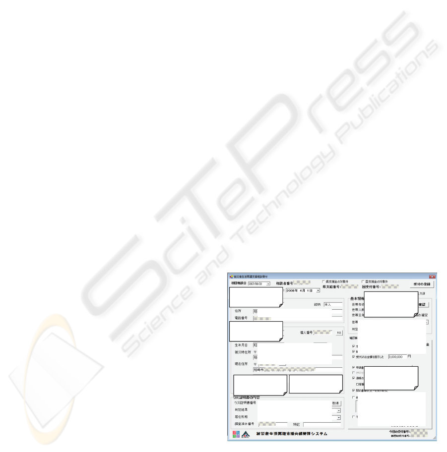
system was thus developed and installed. The items
in the user-interfaces in this developed system were
written in Japanese, because local responders were
not familiar with English. Some of them are shown
in Figure 5 and Figure 6 with English explanation.
Information of
consulters
Information of
suffe redpeople
CertificatedDegree
ofBuildingDamage
Ownershipof
DamagedBuildings
BasicInformation
ofvictims’
household
Progressof
consultationto
victims
Name,Address, Tel
Name,Address,Birthday,
ResidentRegistration
Number,etc.
BuildingDamage, Owner’s
Name,
TaxDebtor’s Name, etc.
AnnualIncome,
Numberofpeoplein
household,
TypeofHousehold, etc.
StepsofTransaction
betweenResponders
andApplicants
Figure 5: UI for browsing victims’ situation.
HEALTHINF 2010 - International Conference on Health Informatics
384

Circumstanceof
Housings
Categorized
Individual
Problems
Decisionfor
IndividualSupport
ProgressofLife
RecoveryProcess
LogsofVisits
Problems
zHousings
zPhysical/MentalHealth,
zEconomic/FinancialSituation
zFamilyIssue etc
Figure 6: UI for browsing individual problems.
6 CONSOLIDATION OF STATUS
ASSESSMENT OF THE
RECOVERY PROCESS
6.1 Visualization of Temporary
Housing Status using Deformed
Maps
This research aims to consolidate the process of
status assessment based on the 3 layers shown in the
previous section. Here, the aim is to amalgamate the
three layers within one map. Because the 3 layers
each differ in scale, it is difficult to visualize on one
piece of paper.
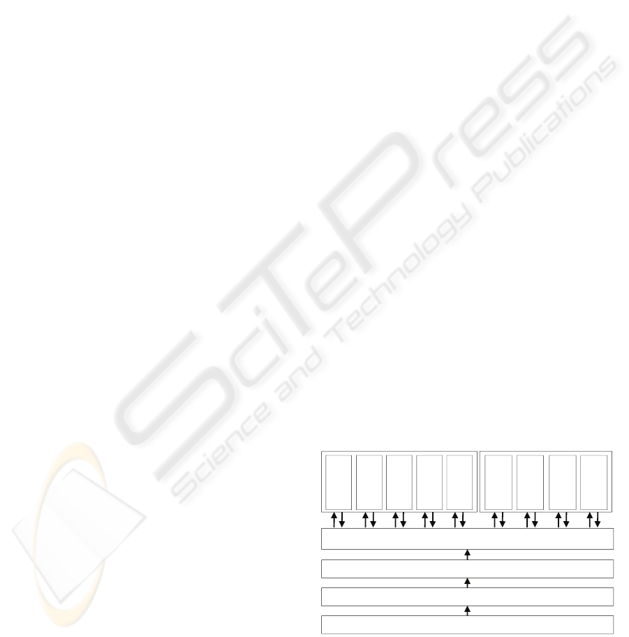
Therefore, it was decided to create a deformed
map in which each temporary housing is expanded
so that individual rooms can be visualized, while
maintaining the relative positional relationships
between each temporary housing as shown in Figure
7. This map thus assisted in consolidation of status
assessment which maintains a continuous viewpoint
from a general level to an individual level. In this
research, we visualized the status of victims’ life
recovery progress based on this map-template.
Figure 7: Map Template to Visualize Progress of Life
Recovery in Temporary Housings.
6.2 Realization of a COP Relating to
Status of Temporary Housing
Residents
1) Visualization of Overall Recovery Status for
Temporarily Housing
This map spatially visualizes information which
shows the overall progress towards reconstruction
and any issues which are outstanding. This allows
the user to gain an overall understanding of the
progress of various reconstruction support measures
being carried out. This also became the basic
information source for policy decisions in terms of
merging of temporary housing facilities with small
numbers of occupants.
2) Visualization of Temporary Housing Recovery
Schedule on a Housing Complex Scale
In this map, one temporary housing complex was
considered as one unit, and the occupancy statuses
of temporary housing were visualized according to
expectations of reconstruction progress. This
allowed measures relating to issues such as snow
removal operations and control of quality of water in
water tanks in each housing complex to be planned
in advance.
REALIZATION OF EFFECTIVE DISASTER VICTIM SUPPORT THROUGH INFORMATION INTEGRATION AND
VISUALIZATION USING GIS
385

3) Visualization of Reconstruction Policy on a
Household Basis
This map visualizes outstanding issues and
reconstruction progress statuses on a household-by-
household basis. Discussion was carried out in terms
of resolving issues for each individual household,
based on a map showing a visual representation of
information on an individual basis for each
household. Figure 8 shows the victims who had
family issues in the way of life recovery with red
colour symbol, and Figure 9 shows the victims who
had physical or mental health issues with red colour
symbol.
7 FUTURE DEVELOPMENT OF
THIS RESEARCH
Temporary housings in Kashiwazaki City are
expected to be taken down within this year. Disaster
victims who still have difficulty in reconstructing
their homes at that time will then be moved to
disaster relief public housing. We aim to continue
assisting such victims, taking their individual
circumstances into account, using the system
described in this research. We also believe that
continued assessment in other future cases will lead
to the system described in this research becoming
standard, and contributing significantly to
implementation of effective life reconstruction
support for disaster victims.
Figure 8: Visualization Map of Victims with Family Issues.
Figure 9: Visualization Map of Victims with
Physical/Mental Health Issues.
ACKNOWLEDGEMENTS
This research was supported by Niigata Chuetsu
Earthquake Recovery Fund, Crisis Management and
Long-Term Recovery Projects under “Special
Project for Earthquake Disaster Mitigation in Tokyo
Metropolitan Area” by MEXT, and R&D Focus
Area: Governance in Ubiquitous Society
“Development of Problem-Solving Capacity for
Crisis Management Using GIS” by RISTEX, JST.
This work was supported by ‘Niigata Prefecture
Chuetsu-oki Earthquake Digital Data Sharing and
Utilization Council’.
REFERENCES
Furuya, T., et al., 2008, Practical Utilization of Maps with
Geo-Referential Relational Database to Support
Measures for Recovery and Reconstruction at EMC-K,
Niigata-ken Chuetsuoki Earthquake 2007, Journal of
Social Safety Science, No.10, pp.301-310.
Inoguchi, M., et al., 2007, Coaching Effective Operation
Procedures using GEOINT Database for Local
Disaster Responders based on Short-term Education
HEALTHINF 2010 - International Conference on Health Informatics
386

Model, Journal of Social Safety Science, No.9,
pp.177-187.
Inoguchi, M., et al., 2008, Implementation of Management
System for Supporting Victims’ Life Recovery Process
Based on the Victim Master Database, Journal of
Social Safety Science, No.10, pp.553-564.
Tamura, K., et al., 2001, A Quantitative Verification of the
Seven Elements Model of Socio-Economic Recovery
from the Kobe Earthquake, Journal of Social Safety
Science, No.3, pp. 33-40.
Tamura, K., et al., 2009, Clarifying the Situation of the
Victims with Special needs on Evacuation Site Using
the 7 Livelihood Domain Model, Journal of Social
Safety Science, No.11, printing.
Tatsuki, S., et al., 2009, People with Special Needs and
Disasters:Person-in-Environment Model GIS Mapping
and Multi-Stakeholder Collaborations, The 1st
International Conference on Policy & Research for
Global Disaster Management (PR4GDM).
Tatsuki, S., et al., 2009, Evacuation & Sheltering
Assistance for Persons with Special Needs at Times of
Disaster: Lessons Learned from Typhoon 23, Heavy
Rainfall and Earthquake Disasters in Year 2004,
Korean Society for Hazard Mitigation.
Yoshitomi, N., et al., 2009, The Development of Disaster
Victims Database Utilizing the GeoWrap Method,
Journal of Social Safety Science, No.11, printing.
REALIZATION OF EFFECTIVE DISASTER VICTIM SUPPORT THROUGH INFORMATION INTEGRATION AND
VISUALIZATION USING GIS
387
