
Conception and Implementation of an OGC-compliant Sensor
Observation Service for a Standardized Access to Raster Data
Juergen Sorg and Ralf Kunkel
Research Center Juelich - Institute of Bio- and Geosciences (IBG-3), Leo Brandt Strasse, Juelich, Germany
Keywords: TERENO, Sensor Observation Service, SOS, SWE, OGC, Raster Data.
Abstract: The target of the Open Geospatial Consortium (OGC) is interoperability of Geographic Information
Systems (GIS), which means creating opportunities to access geodata in a consistent, standardized way. In
the domain of sensor data, the target will be picked up within the OGC Sensor Web Enablement Initiative
and especially reached through the Sensor Observation Service (SOS) specification. This one defines a
service for a standardized access to time series data and is usually used for in-situ sensors (like discharge
gauges, climate stations). Although the specification considers raster data, no implementation of the
standard for raster data exists presently. In this paper an OGC-compliant Sensor Observation Service for a
standardized access to raster data is described. A data model was developed, which enables an effective
storage of the raster data with the corresponding metadata in a database, reading this data in an efficient way
and encoding it with result formats that the SOS-specification provides.
1 INTRODUCTION
Long term changes of temperature, precipitation and
other climate parameters have direct and indirect
influences to the terrestrial systems soil, air and
water and result in social, economical and political
effects to the society.
To understand and predict these interconnected
and continuously evolving processes of the earth
system integrated models to quantify theses effects
need to be developed. However, these models
require the observation and analysis of long-term
data sets from different scientific topics, e.g. from
physics, chemistry, meteorology, geology or
anthropology. In this context the development and
implementation of Spatial Data Infrastructures (SDI)
for terrestrial research is gaining importance.
TERENO (Terrestrial Environment
Observatories) is an interdisciplinary long term
research project initialized by the Helmholz
association, which gathers long term ecological,
social and economical results of global change on a
regionally scale (Zacharias, Bogena et al. 2011).
Four terrestrial observatories are established, which
are coordinated by five Helmholtz research centers.
Installation of equipment has started in 2007 and
will be finished in 2013. Data collection, however, is
planned to be performed for at least 30 years. Within
these observatories sensor networks for intensive
measurement of soil moisture, soil temperature,
water gauge as well energy and fluid fluxes are
deployed. In addition, four weather radar and rain
scanner devices to remotely measure precipitation
rates quantities have been installed.
Observed data from each observatory are stored
and published in decentral infrastructures, each
operated by the individual centers responsible for an
observatory. The data portal TEODOOR (TEreno
Online Data repOsitORy: http://www.tereno.net)
provides access to the data for scientists and
stakeholders and allows to search in metadata
catalogs, visualize the data as well as to download it.
Heterogeneity of observed data, but also different
measurement technics and usage of different
database systems require the application of metadata
standards to describe data and measurement technics
as well as the access to distributed data and metadata
using standardized interfaces (Botts, Percivall et al.
2008). The Open Geospatial Consortium (OGC)
defines these standards and provides specifications
of interfaces for an interoperable access to geo data,
which services have to implement.
In-Situ measurement stations for observing
physical phenomenons (e.g. temperature, soil
moisture, etc.) always related to a single geographic
point. In contrast, remote sensing stations deliver
421
Sorg J. and Kunkel R..
Conception and Implementation of an OGC-compliant Sensor Observation Service for a Standardized Access to Raster Data.
DOI: 10.5220/0004868904210427
In Proceedings of the 3rd International Conference on Sensor Networks (MOEOD-2014), pages 421-427
ISBN: 978-989-758-001-7
Copyright
c
2014 SCITEPRESS (Science and Technology Publications, Lda.)

area differentiated data, related to a certain
geographic area. The common approach for
standardized access to raster data is the OGC Web
Coverage Service (WCS) specification (OGC 2003,
OGC 2010b). However, a WCS cannot be used for
time series, since the datasets stored within a WCS
have no temporal relation. Therefore, the OGC
(OGC 2011b) defines a specialization of the WCS
specification for earth observations (WCS-EO),
which requires to describe each dataset by an
additional metadata set. This additional metadata set
allows to identify the temporal relation for each
raster data set and enables on the other hand the
possibility to subsume datasets to identifiable and
queryable sets (Dataset Series). A description of
each data set can be retrieved by the new operation
(DescribeEOCoverageSet), whereas datasets itself
can be selected by temporal filters. In a second step
data are requested with the GetCoverage operation
using the unique identifiers.
A new approach to manage raster time series
data supports the OGC sensor observation service
(SOS) specification. It comprises methods for a
standardized access to all kinds of time series data
with spatial relation to the earth. The advantage of
using a SOS instead of a WCS-EO is the inherence
of the temporal relation of each dataset, since a SOS
is particularly designed for managing time series.
Temporal selection of datasets is performed in a
direct way rather than using an additional operation
with an afterwards extraction of the required
identifiers. Furthermore, a SOS supports to apply
thematic filters to extract thematic attributes of raster
data sets. In this paper we describe the conception
and implementation of an OGC compliant SOS for a
standardized access to raster time series data, which
allows to select raster data sets using temporal,
spatial and thematic filters and to deliver it in a
standardized way. In addition, a solution is
described, which prepares the data for a fast
perfunctory verification in a time critical
visualization on a web page and gives a standardized
access.
2 OGC SENSOR OBSERVATION
SERVICE
The Open Geospatial Consortium (OGC) is a
confederation of leading GIS manufacturer, data
producers, authorities, organizations, research
facilities and universities. It was founded in 1994
and since it develops metadata standards and
standardized interfaces for an interoperable access to
geographic data. The Interoperability of sensor and
sensor networks are covered by the Web Enablement
Initiative of the OGC (Bröring, Echterhoff et al.
2011). Within these initiative there are several to
each other aligned standards and interfaces defined:
Sensor Observation Service (SOS) specification
defines a standardized web service to search,
filter and retrieval sensor data and sensor
information (OGC 2006a, OGC 2012a).
Observation & Measurement is a standard to
describe and deal with observational data (OGC
2007a, OGC 2007b, OGC 2010a, OGC 2011a).
It is majorly used to encode geo data, which a
SOS delivers
Sensor Model Language (SensorML) is a
information model to describe sensors and the
observed properties (OGC 2007d).
Sensor Alert Service (SAS) gives users over a
standardized interface the possibility to receive
alert messages from sensors (OGC 2007c).
Presently there is a discussion about extending
the SAS to a Sensor Event Service (SES), which
is able to handle all kinds of event messages
(OGC 2008).
Beside these standards the SWE also comprises
the standards Transducer Model Language (TML),
Sensor Planing Service (SPS) and Web Notification
Service (WNS), which are not within the scope of
the paper.
The SOS specification comprises eleven operations
to access observation data, but only the operations
GetCapabilities, DescribeSensor and
GetObservation are mandatory. The GetCapabilities
Operation yields general information about the
service and all information necessary to call the
supported operations. The DescribeSensor Operation
yields a description of a sensor encoded by the
SensorML language (OGC 2007d) and contains
among others identifiers for the observed properties,
coordinates of the station and a time domain for
which data is available. Finally, data can be
requested by means of the GetObservation
operation. The XML fragment within Example 1
displays an example of a GetObservation request
with all available parameters (OGC 2006a).
1<GetObservation>
2 <offering>Reflectivity</offering>
3 <eventTime>
4 <o:TM_During>
5 <o:PropertyName>
6 om:samplingTime
7 </o:PropertyName>
8 <gml:TimePeriod>
9 <gml:beginPosition>
SENSORNETS2014-InternationalConferenceonSensorNetworks
422
10 2012-01-07T10:28:54
11 </gml:beginPosition>
12 <gml:endPosition>
13 2012-01-07T12:28:54
14 </gml:endPosition>
15 </gml:TimePeriod>
16 </o:TM_During>
17 </eventTime>
18 <procedure>WRadar</procedure>
19 <observedProperty>
20 Reflectivity
21 </observedProperty>
22 <featureOfInterest>
23 <o:Intersects>
24 <o:PropertyName>
25 urn:ogc:data:location
26 </o:PropertyName>
27 <gml:Point
28 srsName="EPSG::31466">
29 <gml:pos>
30 5657550.5 2606247.0
31 </gml:pos>
32 </gml:Point>
33 </o:Intersects>
34 </featureOfInterest>
35 <om:result>
36 <o:PropertyIsGreaterThan>
37 <o:PropertyName>
38 Reflectivity
39 </o:PropertyName>
40 <o:Literal>36</o:Literal>
41 </o:PropertyIsGreaterThan>
42 <om:result>
43 <responseFormat>
44 text/xml;subtype=“OM/1.0.0“
45 </responseFormat>
46 <resultModel>
47 om:TimeSeriesObservation
48 </resultModel>
49 <responseMode>Inline</responseMode>
50</GetObservation>
Example 1: GetObservation request with all available
parameters.
The unique and mandatory Offering identifies a free
selectable, use case dependent logical combination
of sensors (e.g. by observed properties) (OGC
2006a). The parameters for temporal, spatial and
thematic filters (eventTime Line 3-17,
featureOfInterest Line 22-34 und result Line 35-42)
and the unique identifiers of the station (procedure
Line 18) and the observed properties
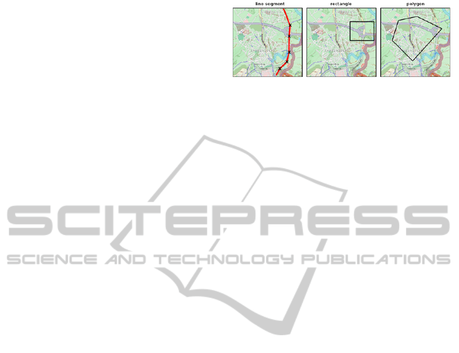
(observedProperty Line 19) are optional. Figure 1
shows some examples of spatial filters that are
supported by the SOS specification. On the left side
a line segment filter is depicted, which extracts all
values located on a street course. In the center a
rectangle filer and on the right hand side a not
orthogonal polygonal filter is depicted. Both filters
selecting objects located within the filter face.
Beside the spatial filters, the SOS specification
also provides thematic compare filters, which selects
objects not by their location but by means of values
Figure 1: spatial filters provided by a SOS (left: line
segment filter, center: rectangle filter and right: polygonal
filter).
of a variable. In lines 35-42 of Example 1 a thematic
filter is specified, which selects all meshes of a
raster dataset, that attribute „Reflectivity“ has a
value greater than 36.
The SOS processes requests under consideration
of the specified filter conditions and returns the
results as O&M documents (OGC 2007a, OGC
2007b, OGC 2010a, OGC 2011a). Thereby the
O&M standard facilitates to encode vector data as
well raster data by use of XML documents. Crucial
thereby is, that despite of the very different structure
the O&M standard provides both, the encoding of
raster and vector data (OGC 2007b). On the one
hand the generalized coverage model of ISO19123 is
used to encode raster data. On the other hand vector
data are covered with several for this purpose
specifically developed models. Within a
GetObservation request the desired result model is
specified by the Parameter resultModel (line 46 in
example 1) (OGC 2006a). Therefore, it is possible to
request raster as well as vector data from a SOS in a
standardized way. But certainly, raster data are not
supported from the common SOS implementations.
3 IMPLEMENTATION
There exist a huge number of implementations of the
SOS standard in any kind of programming languages
(Nengcheng, Liping et al. 2009). Because the SOS
implementation of the 52°North company is easily
modifiable it was used to be extended to give access
to raster data in a standardized way. Following steps
were necessary to achieve this, which are explained
in following sections:
A data model, based on the 52°North SOS data
model, to store the raster data and its describing
metadata in an efficient way was developed (see
Figure 2)
Efficient algorithms to apply filters were
implemented.
Several O&M models to return the raster data in a
standardized and flexible manner were realized
ConceptionandImplementationofanOGC-compliantSensorObservationServiceforaStandardizedAccesstoRaster
Data
423

3.1 Data Model
The raster data are stored in a relational database
management system (RDBMS), whereas
PostgreSQL (Pfeiffer and Wenk 2010) with the
PostGIS (Obe and Hsu 2011) extension for spatial
data are used. Although the new PostGIS version
(2.0) supports raster data, it cannot be used here,
because PostGIS intends to use one table for each
raster data set (Holl 2012). Within the TERENO
project a huge number of raster datasets (up to 1.5
Mio. weather radar data sets within the project
period) will be created, making the usage of PostGIS
raster data tables not practicable. Therefore, a data
model was developed, which supports to store all
raster data in one single data table. This can be
accomplished in two different ways: as a binary
large object (BLOB) or row based. A BLOB is a
database type for large, not nearer specified binary
objects. Because there is no additional information
about the stored object in a BLOB, the amount of
space is minimized on the field of table layer.
Certainly storage in a BLOB is inconvenient for a
thematic filtering of the data, because in this case the
entire binary object must be read and for each raster
mash the filter condition must be proofed. Keeping
each raster mesh in a row of a data table has sure the
advantage that searching can be done in an efficient
manner, but the considerable disadvantage is the
large amount of inserts and rows that accrue for each
raster dataset (e.g. for a relative small raster with
800x800 pixels 640000 inserts and rows must be
handled).
To achieve an efficient thematic search within
the raster data a new coarser grid was used, which is
a compromise between a small storage space and an
efficient access. In this manner database indices can
be used to have a more efficient access then it can be
achieved with a sequential method (Kemper and
Eickler 2006). The coarser grid is in its resolution
free selectable and keeps for each of its raster
meshes the maximum and minimum of the under
laying original raster meshes. The resolution is
selected in this way, as on one hand inserts can be
done in an adequate time frame and on the other
hand not too much original pixel have to be read and
proofed.
Figure 2 shows the developed data model. The
time series describing meta data is distributed stored
over the normalized tables coverage_structure,
phenomenons, stations, offerings and coverage_-
out_of_band. Moreover the coarser grid is also
normalized in the tables coverage_coarse_raster and
coverage_coarse_geometry. And finally the raster
data itself is stored as a BLOB field in the table
weatherradar_coverage with a foreign key link to its
time series in table coverage_structure.
3.2 Filter
The existing filters of the 52°North implementation
are coupled to the database intrinsic functions, they
only support vector based requests. However, for our
developed SOS for raster data, it is required to have
filter operations, which can be applied also to raster
data. Our implementation supports thematic as well
as spatial filters. The former selects raster cells by
means of values of a variable. This is realized with
the aforementioned coarse grid, which has the
advantage, as only relevant pieces of the original
dataset must be read. Because the selected pixel
within the coarse raster always represents an
orthogonal polygon, an efficient sweep algorithm
(Güting and Dieker 2004) was implemented to read
these orthogonal faces. Figure 3 shows a clip of such
an orthogonal polygon. The sweep algorithm scans
Figure 2: Data model.
SENSORNETS2014-InternationalConferenceonSensorNetworks
424
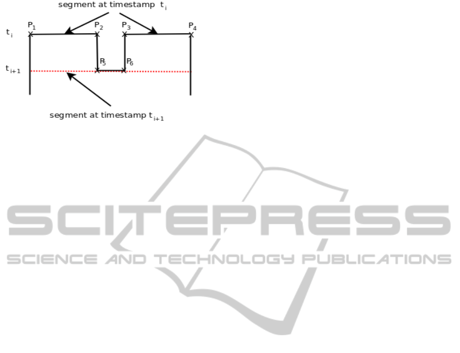
Figure 3: Sweep algorithm to scan orthogonal polygons.
the polygon in vertical direction from top to bottom
and holds line segments in a temporary cache, which
mark domains that can be read in blocks from the
original raster dataset. Only for these pixels the filter
condition must be proofed and if they pass then the
raster mesh is appended to the result set.
The sweep algorithm is also usable for spatial
filters, which are dealing directly with the original
raster dataset (not over the coarse grid). This is only
possible, if the spatial filter is orthogonal (see Figure
1). If the spatial filter is not orthogonal, the sweep
algorithm is not usable. In this case a vectorized
representation of the raster is used, which holds for
each raster mesh from the original raster the
geometry and the index of the cell. With this
vectorized raster it is possible to use the PostGIS
instrinsic functions like intersects, contains, etc.
(Obe and Hsu 2011). Moreover, our implementation
supports any spatial filter geometry, which is
encodeable with GML within the GetObservation
request. This is because the GML encoded filter can
easily transformed to the WKT (Well Known Text)
format (OGC 2011c), which is the encoding format
for filter geometries of the aforementioned PostGIS
functions.
3.3 Result Models
Two different kinds of methods were implemented
to return the result sets. First there are used O&M
models for the direct encoding of the raster data.
These are the DiscreteCoverage-Observation, the
TimeSeriesObservation and a generic O&M model
(OGC 2007b) (Broering and Meyer 2008), which are
used to encode spatial and thematic filtered data.
Second, there are entire raster datasets provided as
georeferenced images over an external OGC
compliant Web Map Service.
For the direct transfer, specified by the parameter
INLINE of the GetObservation request (see example
1), two different models were implemented. Both
models are included from the ISO19123 standard
(ISO 2005). The DiscreteCoverageObservation
O&M model can be used for the encoding of spatial
and thematic filtered data, while the
TimeSeriesObservation O&M model is suitable for
the encoding of a time series of a selected raster
mesh. In this case the requests use a point filter.
Example 2 shows the geometry value pair of a raster
mesh encoded with the
DiscreteCoverageObservation model.
<ns:element>
<ns:CV_GeometryValuePair>
<ns:geometry>
<ns:CV_DomainObject>
<ns:spatialElement>
<gml:Polygon srsName="EPSG::31466"
xsi:type="gml:PolygonType">
<gml:exterior>
<gml:LinearRing
xsi:type="gml:LinearRingType">
<gml:coordinates>
5640414.72905 2468620.92429,
5640664.72905 2468620.92429,
5640664.72905 2468870.92429,
5640414.72905 2468870.92429,
5640414.72905 2468620.92429
</gml:coordinates>
</gml:LinearRing>
</gml:exterior>
</gml:Polygon>
</ns:spatialElement>
</ns:CV_DomainObject>
</ns:geometry>
<ns:value
uom="dbz"
xsi:type="gml:MeasureType">
8.944881889763703
</ns:value>
</ns:CV_GeometryValuePair>
</ns:element>
Example 2: Geometry value pair of a raster mesh encode
with the DiscreteCoverageObservation-model.
The geometry is encoded as a polygon in the
Geography Markup Language (GML), while the
thematic value is encoded as a decimal value with its
unit of measure (UOM). In a similar manner the
dataset is encoded in the TimeSeriesObservation
model, but here the geometry is replaced by a
timestamp. Because both models are xml based and
very character intensive, a third generic O&M model
(OGC 2007b) was used to encode the data with
comma separated values. For each raster cell the
index or the geometry and the value are given.
For the indirect transfer of data the SOS
specification provides the possibility to answer to a
GetObservation request with a reference to an
external source (OGC 2007b). We use this option to
provide the raster data as a georeferenced image
ConceptionandImplementationofanOGC-compliantSensorObservationServiceforaStandardizedAccesstoRaster
Data
425

from an OGC compliant Web Map Service (WMS)
(OGC 2006b). References are encoded in a generic
O&M model. Within the GetObservation request the
response mode is given by the value OUT-OF-
BAND for the parameter ResponseMode. Example 3
shows a reference to a raster image provided by a
WMS and encoded with a generic O&M model.
<om:member>
<om:Observation>
<om:samplingTime>
<gml:TimeInstant
xsi:type="gml:TimeInstantType">
<gml:timePosition>
2012-10-10T06:00:00.000+02:00
</gml:timePosition>
</gml:TimeInstant>
</om:samplingTime>
<om:procedure xlink:href="WRradar"/>
<om:observedProperty
xlink:href="Reflectivity"/>
<om:featureOfInterest>
<gml:GridCoverage gml:id="WRadar">
<gml:name>Weatherradar</gml:name>
<gml:boundedBy>
<gml:Envelope>
<gml:lowerCorner
srsName="EPSG::31466">
5543664.729 2432120.924
</gml:lowerCorner>
<gml:upperCorner
srsName="EPSG::31466">
5743664.729 2632120.924
</gml:upperCorner>
</gml:Envelope>
</gml:boundedBy>
<gml:gridDomain/>
<gml:rangeSet>
<gml:ValueArray/>
</gml:rangeSet>
</gml:GridCoverage>
</om:featureOfInterest>
<om:result
xsi:type="gml:ReferenceType"
xlink:href=
"http://www.menja.de:8080/geoserver/wms?serv
ice=WMS&version=1.1.0&request=GetMap&
layers=tereno:2012-10-10_06-00-
00&styles=&bbox=2463655,5436699,2663655,5636
699&width=800&
height=800&srs=EPSG:31466&format=image/png"/
>
</om:Observation>
</om:member>
Example 3: Reference to a raster image provided by a
WMS and encoded with a generic O&M model.
4 CONCLUSION AND OUTLOOK
In this paper we explained the concept and an
implementation of an OGC compliant SOS for an
interoperable access to area related raster time
series. To give applications the opportunity to
request entire raster data sets for a visualization of
the data, a system was implemented, that uses the
raster SOS to select the desired datasets and an OGC
WMS to provide the datasets as georeferenced raster
images. The selection of the datasets is efficient,
because database indices can be used. The
interoperability and the use of standard web software
like OpenLayers, but also the retrieval of the
datasets in an acceptable time slot is given by using
an OGC compliant WMS.A data model to store
raster time series data in an efficient manner but also
software components for an efficient access to this
raster data was implemented. The implemented
algorithm allows the retrieval of raster datasets by
thematic, spatial and temporal filters. With the
algorithms extracted data is encoded with different
O&M-models, to support suitable models for
different use cases.
Because of the verbosity of O&M coverage
models, in particular of the DiscreteCoverage
model, this models are not feasible to deliver raster
data in a reasonable time. Therefore a generic O&M
model with a comma separated encoding of the data
was implemented.
The approach to use a SOS to manage raster data
has several advantages mentioned already in the
introduction. But to deliver data in a well known
scientific owned data format like NetCDF is an
advantage the WCS approach has. To adapt this a
mapping between O&M and NetCDF must be
defined. In (OGC 2012b) this is done for WaterML,
which is a profile to the O&M Standard for
hydrological data. In further work this can also
accomplished for an O&M coverage model.
The implemented OUT-OF-BAND method is not
limited for external resource hosted on a WMS. It is
also usable in conjunction with a WCS. An
interesting question for this is how the filters defined
in a GetObservation request can be transformed to
filters in a WCS GetCoverage request.
ACKNOWLEDGEMENTS
We gratefully acknowledge the support by
TERENO (Terrestrial Environmental Observatories)
funded by the Helmholtz Association.
REFERENCES
Botts, M., G. Percivall, C. Reed and J. Davidson (2008).
OGC® Sensor Web Enablement: Overview and High
Level Architecture. S. Nittel, A. Labrinidis and A.
SENSORNETS2014-InternationalConferenceonSensorNetworks
426

Stefanidis, Springer Berlin / Heidelberg. 4540: 175-
190.
Broering, A. and O. Meyer (2008). Bereitstellung und
Visualisierung hydrologischer Zeitreihen mit Hilfe
standardisierter Webdienste. Proceedings: AGIT2008
Symposium und Fachmesse., Salzburg, Österreich.
Bröring, A., J. Echterhoff, S. Jirka, I. Simonis, T.
Everding, C. Stasch, S. Liang and R. Lemmens
(2011). "New Generation Sensor Web Enablement."
Sensors 11(3): 2652-2699.
Güting, R. H. and S. Dieker (2004). Datenstrukturen und
Algorithmen, Teubner Verlag.
Holl, S. (2012). PostGIS Raster Workshop. FOSSGIS
2012, Dessau-Rosslau, FOSSGIS.
ISO (2005). Geoinformation – Coverage Geometrie- und
Funktionsschema (DIN EN ISO 19123), DIN
Deutsches Institut für Normung e.V.: 71.
Kemper, A. and A. Eickler (2006). Datenbanksysteme -
eine Einführung, Oldenbourg Wissenschaftsverlag
GmbH.
Nengcheng, C., D. Liping, Y. Genong and M. Min (2009).
"A flexible geospatial sensor observation service for
diverse sensor data based on Web service." ISPRS
Journal of Photogrammetry and Remote Sensing
64(2): 234 - 242.
Obe, R. O. and L. S. Hsu (2011). PostGIS in Action,
Manning Publications.
OGC (2003). Web Coverage Service (WCS) Wayland,
MA, USA, Open Geospatial Consortium Inc.: 67.
OGC (2006a). OpenGIS Sensor Observation Service
Implementation Specification. Wayland, MA, USA,
Open Geospatial Consortium Inc.: 91.
OGC (2006b). OpenGIS® Web Map Server
Implementation Specification, Open Geospatial
Consortium Inc.
OGC (2007a). Observations and Measurements – Part 2 -
Sampling Features, Open Geospatial Consortium Inc.:
36.
OGC (2007b). Observations and Measurements. Part 1:
Observation schema Wayland, MA, USA, Open
Geospatial Consortium Inc.: 85.
OGC (2007c). OGC® Sensor Alert Service
Implementation Specification, Open Geospatial
Consortium Inc: 128.
OGC (2007d). OpenGIS Sensor Model Language
(SensorML). Implementation Specification. Wayland,
MA, USA, Open Geospatial Consortium. 1.0.0: 180.
OGC (2008). OpenGIS® Sensor Event Service Interface
Specification (proposed), Open Geospatial Consortium
Inc.: 88.
OGC (2010a). Geographic Information: Observations and
Measurements. OGC Abstract Specification Topic 20,
Open Geospatial Consortium Inc. 2.0.0: 57.
OGC (2010b). OGC® WCS 2.0 Interface Standard - Core,
Open Geospatial Consortium Inc.: 45.
OGC (2011a). Observations and Measurements. XML
Implementation. Wayland, MA, USA, Open
Geospatial Consortium. 2.0: 76.
OGC (2011b). OGC® Web Coverage Service 2.0
Interface Standard - Earth Observation Application
Profile, Open GeoSpatial Consortium Inc.: 48.
OGC (2011c). OpenGIS® Implementation Standard for
Geographic information - Simple feature access - Part
1: Common architecture, Open Geospatial
Consortium, Inc.: 92.
OGC (2012a). OGC® Sensor Observation Service
Interface Standard, Open Geospatial Consortium: 148.
OGC (2012b). WaterML 2.0 – Timeseries – NetCDF
Discussion Paper. Open Geospatial Consortium Inc.:
72.
Pfeiffer, T. and A. Wenk (2010). PostgreSQL : das
Praxisbuch. Bonn, Galileo-Press.
Zacharias, S., H. Bogena, L. Samaniego, M. Mauder, R.
Fuß, T. Pütz, M. Frenzel, M. Schwank, C. Baessler, K.
Butterbach-Bahl, O. Bens, E. Borg, A. Brauer, P.
Dietrich, I. Hajnsek, G. Helle, R. Kiese, H.
Kunstmann, S. Klotz, J. C. Munch, H. Papen, E.
Priesack, H. P. Schmid, R. Steinbrecher, U.
Rosenbaum, G. Teutsch and H. Vereecken (2011). "A
Network of Terrestrial Environmental Observatories
in Germany." Vadose Zone Journal 10(3): 955-973.
ConceptionandImplementationofanOGC-compliantSensorObservationServiceforaStandardizedAccesstoRaster
Data
427
