
A Semantic Geodatabase for Environment Analysis
Extraction, Management and Sharing of Earth and Water Information in GIS
Andrea Lingua and Francesca Noardo
Politecnico di Torino, DIATI, c.so Duca degli Abruzzi, 24, 10129 Torino, Italy
{andrea.lingua, francesca.noardo}@polito.it
Keywords: Geographic Information System, Geoprocessing, Ontology, Digital Maps, Geodatabase.
Abstract: The great potential of GIS to manage and analyse georeferenced information is well-known. The last several
years of development of ICT (Information and Communication Technologies) saw a necessity of
interoperability arise, from which the Semantic web standards and domain ontologies are derived. Specific
application field ontologies are often insufficient for representing the information of multidisciplinary
projects. Moreover, they are often aimed at the representation of homogeneous data formats (alphanumeric
data, vector spatial data, raster spatial data, etc.). In this scenario, traditional GIS often have a limit: they
implement personal data models, which are very difficult to exchange through different systems. In this study
we structured a GIS for the monitoring project ALCOTRA ALIRHYS according to parts of two different self-
integrated ontologies, from the perspective of the major interoperability of the system and the sharing of data
through a web-GIS platform. The two standard models chosen (SWEET ontology and INSPIRE UML model)
have been integrated in a unique conceptual model useful both for geometric and cartographic data, and for
thematic information. In this case, the implemented schemas are published on the project website, and are
available for other users who want to produce similar studies. Since user-friendly results were desirable, some
integrated commercial widespread software programs have been used even if their abilities to manage such a
GIS are suboptimal.
1 INTRODUCTION
Traditionally, Geographic Information Systems
(GIS) are powerful instruments for storing geospatial
data in digital archives and managing these data for
inferring further knowledge, extracting spatial
information and realizing geometric and
morphological analysis. Another basic capability of
GIS is the archiving of dynamic data related to
monitored values in a “many to one” relation with
reference to spatial objects. These can be queried and
represented on the land, with additional consideration
of the time at which the data have been acquired (the
4
th
dimension managed by GIS).
Since the mid-1990s some research has further
developed these systems. In particular, a need for
interoperability arose; the solution was found in
ontologies, in order to better manage the semantic
content of spatial data (Freksa and Barkowsky, 1996;
Fonseca et al., 2002), and in object-oriented GIS
(Scholl and Voisard, 1992), which permitted the
implementation of some important characteristics of
the semantic structure (Mennis, 2003). Today, the
achievement of the evolution of the World Wide
Web, the Semantic Web, offers theories and
structures that make the theorized interoperability a
reality (Waters et al., 2009). Standard languages and
services foster this aim: OGC (Open Geospatial
Consortium) published standards for spatial data
exchange, such as WMS (Web Map Service), WFS
(Web Feature Service), WCS (Web Coverage
Service), WPS (Web Processing Services) and so on.
Moreover, the semantic web offers more standards
and tools aimed at reaching maximum data
integration and exchangeability. Structuring data by
means of these tools offers an enhanced ability to run
automated reasoning and evolved queries on
published spatial data. In several fields of application
some standard ontologies have been developed, as
references for the management of the semantic
content of represented data (Pundt and Bishr, 2002).
However, these ontologies often seek to represent
alphanumeric data, without concern for spatial
implications. In the meantime, other ontologies, such
as CityGML (OGC, 2008) or INSPIRE UML
(Unified Modelling Language) model
213
Lingua A. and Noardo F..
A Semantic Geodatabase for Environment Analysis - Extraction, Management and Sharing of Earth and Water Information in GIS.
DOI: 10.5220/0005379002130220
In Proceedings of the 1st International Conference on Geographical Information Systems Theory, Applications and Management (GISTAM-2015), pages
213-220
ISBN: 978-989-758-099-4
Copyright
c
2015 SCITEPRESS (Science and Technology Publications, Lda.)

(http://inspire.ec.europa.eu/data-model/approved/r46
18-ir/html/), consider the cartography, but are
insufficiently able to manage the data of particular
application fields in a GIS. For this reason the need
for ontology integration arises.
In this paper, the environmental data (geometric
and dynamic data) studied during the European
project ALCOTRA ALIRHYS have been managed in
a GIS and in an external database structured
according to a data model designed by integrating
existing ontologies. The project aims to study
subterranean water resources through several
monitoring activities (www.polito.it/alirhys). In this
way the data produced are codified to be uniquely
interpreted, and to be effectively shareable on the web
without losing part of their meaning. Moreover, when
a GIS or a database is constructed in the traditional
way, the conceptual model used is shared, together
with other metadata, in order to limit interpretation
ambiguity. However, sharing of implemented
structures is not common. In this project, both the
models and the XML schema of the constructed
geodatabase in ESRI ArcGIS and the related database
tables in MS Access are published on the project's
website (www.polito.it/alirhys) in order to foster the
reproduction and the reuse of the method for similar
studies, even in a stand-alone environment.
The advantages of data management in GIS have
been exploited by running different analyses on the
data archived in order to acquire further information,
useful for the monitoring of springs; this work is
described in the final part of this paper.
1.1 Semantic Data Management:
Ontologies and Standards
Representation in many fields of application has been
influenced in recent years by new paradigms
established by the web and informatics technologies.
The Semantic Web is intended to realize a common
framework that allows the meaningful content of data
to be shared, beyond the boundaries of applications,
and to be easily reused for automatic processing.
Permitting an effective semantic interoperability,
documents are associated to metadata that specify the
semantic context in standardized language, and data
are structured according to pre-formatted and known
data models. One of the most powerful tools for
reaching these objectives is the formulation of
domain ontologies, primary conceptual models that
provide completely solution-independent schemas in
order to support modelling in producing suitable
representation structures. A set of standard languages
is available for defining interoperable ontologies
(http://www.w3. org/). Almost all these languages
have as their origin structure the eXtensible Markup
Language (XML), which is then specified in a set of
more evolved structures developed to better express
the logic structure and correcting semantics of data.
W3C (World Wide Web Consortium) is the
organization developing the structures to enable the
Semantic web. It published some specific languages
to model the data in domain ontologies, in order for
the data to be effectively shared. These evolve from
the original RDF (Resource Description Framework)
(http://www.w3.org/RDF/) to more suitable ones for
representing knowledge structures: OWL (Ontology
Web Language) (http://www.w3.org/OWL/), and
some evolutions of it (OWL 2, DAML+OIL, OWL1
DL). These languages are best suited for representing
information in the form of alpha-numeric data, but
they have some lacks in the suitable management of
geometric information.
In this scenario, many domain ontologies are
being developed. Among these, we find the NASA
(National Aeronautics and Space Administration)
SWEET (Semantic Web for Earth and Environmental
Terminology) ontology, intended for the
representation of Earth and Environmental Sciences
(EES) (Raskin, 2004). This ontology is in modelled
in the OWL language, and includes a very high
variety of concepts about both the object studied and
the methodology aspects (research, analysis,
measurements, residuals, etc.); these could be
effectively transposed to other application fields.
SWEET has become the de facto standard for data
management in EES (Di Giuseppe, 2014).
Concurrently, some particular formal languages
have been developed for spatial data. The most
widespread of these are published by the OGC (Open
Geospatial Consortium), an organization founded to
develop publicly available geo-enabled standards. In
particular, it encoded GML (Geography Markup
Language, ISO 19100 series of International
Standards and OpenGIS Abstract Specification),
which is an XML schema for the description of the
application, transport and storage of geographic
information. This has been applied to the formulation
of some standard models - such as CityGML, the
common semantic information model for the
representation of 3D urban objects – and allows these
data to be shared over different applications. Another
fundamental application of GML is the INSPIRE
conceptual model (http://inspire-twg.jrc.ec.europa.eu
/data-model/draft/r4530/), which is the pre-specified
ontology for formulating harmonic and homogeneous
maps in the European Union.
A point of contact between these two fields can be
GISTAM2015-1stInternationalConferenceonGeographicalInformationSystemsTheory,ApplicationsandManagement
214
found in considering the W3C language SPARQL
(SPARQL Protocol and RDF Query Language)
(http://www.w3.org/TR/rdf-sparql-query/), a query
language for RDF structured data. Starting from this
language, OGC developed the geoSPARQL language
(http://www.opengeospatial.org/standards/geosparql
); it defined a vocabulary for representing geospatial
data in RDF, as well as an extension to SPARQL for
processing geospatial data. This language offers the
ability to transition between the languages GML and
RDFS/OWL. In the future, this will provide a good
solution for managing and sharing data, as some
research has already outlined (Tschirner, 2011).
In this study, the available entities have been
extracted from the SWEET ontology in order to
model the environmental objects studied during the
project ALIRHYS. Concurrently, the spatial
properties of objects have been managed by
integrating the selected part of the SWEET ontology
with the entities extracted from the INSPIRE UML
model, to complete the representation for suitable
management in the GIS.
1.2 INSPIRE
The INSPIRE Directive (http://inspire.jrc.ec.europa.
eu/) is a European Union directive aimed at creating
a European spatial data infrastructure, able to
establish a unique network for sharing environmental
spatial information among European nations. The
directive has been in force since 15th May 2007, and
after passing through various stages will be fully
implemented by 2019.
Two of the main principles of INSPIRE are: “It
should be possible to combine seamless spatial
information from different sources across Europe and
share it with many users and applications; […it
should be] easy to find what geographic information
is available, how it can be used to meet a particular
need, and under which conditions it can be acquired
and used.” (INSPIRE, 2007) As in some other works
related to cartography harmonisation (Tóth; 2007;
Afflerbach, 2004) and also in the ALIRHYS project,
our purpose was to respect these two principles by
producing some cartographic data and sharing them
on a WebGIS together with every useful metadata
file.
2 THE EUROPEAN PROJECT
ALCOTRA –ALIRHYS
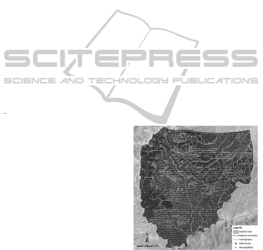
The European project ALCOTRA – ALIRHYS
(2013-2015) has been developed by the partnership
among the Politecnico di Torino, Politech Nice
Sophia, Université Nice Sophia - Antipolis, Regione
Piemonte and the Nice - Côte d’Azur Metropole, with
the aim of studying and monitoring the subterranean
hydric resources in the cross-border mountainous
territory between the provinces of Cuneo and Nice
(Fig.1). These activities are required in light of
climatic changes that have occurred over the last
several years and that increase the risks caused by
climate variability: periods of drought alternated with
flooding are becoming more and more frequent.
Subterranean hydric resources feed several springs in
the territory from which the local hydrographic
network originates, and they also feed several
aqueducts that supply drinking water to users. For this
reason, it is essential to know the chemical
composition of the water and to foresee the influence
of rainfall and snow fusion on the behaviour of the
springs in order to optimize their management
(Bellone et al., 2014). These parameters can only be
studied from a cross-border point of view as the
geological assets influence both sides of the Alps.
Therefore, studies must be carried out in a
comprehensive manner. Furthermore, this cross-
boundary case study justifies the use of standards for
the management of the project’s data; these standards
ensure that data can be shared, queried and used in
analysis.
Figure 1: Study Area of the project ALIRHYS.
In this article, the part of the project regarding the
management, analysis and integration of data in GIS
is presented.
ASemanticGeodatabaseforEnvironmentAnalysis-Extraction,ManagementandSharingofEarthandWaterInformation
inGIS
215

3 APPLICATIONS OF THE
SEMANTIC MODEL IN GIS
FOR ALIRHYS PROJECT
The data of the springs monitoring project ALIRHYS
have been managed in a GIS. As usual, a conceptual
schema for modelling the data is used, but particular
care was taken in choosing entities useful for the
specific needs of the study and appropriate for the two
reference ontologies: the SWEET ontology and the
INSPIRE UML model. The resulting conceptual
model is shown in Figure 2. It shows the entities
present in the INSPIRE conceptual model (in blue),
which have been used mainly for the harmonisation
of digital maps (Noardo et al., 2015); the entities
extracted from the SWEET ontology (bordered in
red) are used to manage the remaining concepts
present in the system. These last ones and some
additional entities are added because the needs of the
project are in turn divided in spatial entities (in
yellow), dynamic data tables (in violet), and
geoprocessing products (in pink). The integration
between the two ontologies is indicated by the green
arrows.
In the implementation, different logic data models
are useful for different data management
requirements. It would be suitable to manage spatial
data in an object-oriented database, as is also implicit
in the structure of standard models. This kind of logic
model enables some meaningful constructs for
cartographic objects, such as polymorphism and
inheritance (Worboys, 2004). On the other hand,
reams of dynamic data can be managed effectively in
a relational database, in which they can be
automatically imported and suitably queried.
Software implementing the hybrid model, an “object-
relational database management system”
(ORDMBS), could have good performance in both
cases (examples of these are PostgreSQL and Oracle).
However, these system are often less widespread than
others that use a relational database model, such as
ESRI ArcGIS or MS Access; these are more
commonly known and, consequently, more user-
friendly. In this situation ease of use is important, so
these last two software programs have been chosen to
permit an easy re-employment of the data and of the
schemas implemented by without advanced
qualifications.
Since the implementation with this kind of
software is not the most ideal, the model has been
divided in three main parts. The first segment
concerns the harmonisation of digital maps (ESRI
ArcGIS); the second manages the representation of
useful georeferenced data of the project (ESRI
ArcGIS), and the third deals with dynamic data
tables, which are managed in an external DBMS
(Database management system), MS Access.
Ontologies and data models are oriented towards
the publication of data on the web and the sharing of
these data through specific web service interfaces.
During this project the aim was to conduct some
analysis on the springs and on the studied area, even
in a stand-alone environment. Only in a final part of
the project have results been published in a WebGIS
using the open-source platform Geonode. The
requirement of respecting defined data models was
useful for obtaining structured data in this case; it
could potentially be implemented in other similar
systems, or shared on the web to enhance the system’s
functionality for future work.
3.1 The ALIRHYS Geodata
3.1.1 The Harmonisation of Digital Maps
As a first step in building a geographic database for
the project map, GIS tools were used to harmonize the
available national cartographic products by
exploiting both their geoprocessing capabilities and
their database characteristics (as better explained in
Noardo et al., 2015).
In this paper we focus on the part of the
harmonisation processes concerning the digital maps.
Analysing the national digital maps, one notices some
differences in the geometric visualisation of objects
due to the origin of the data, the plotting methods, and
the map’s nominal scale. These geometric differences
are too difficult to solve, because doing so would
require the re-plotting of maps or the acquisition of
new homogenous data for the whole area; this is not
within the scope of this project. What is interesting in
this context are the data structures, which have been
analysed and transformed in order to make them
harmonic. To pursue this aim the part of the defined
conceptual model including INSPIRE entities has
been used as a reference.
The national databases were analysed in order to
extract a simplified version of the conceptual model
structuring the maps, considering only entities useful
for our representation needs. The next step was the
mapping of each entity into the selected part of the
INSPIRE model, using a transformation to make the
data homogeneous (Noardo et al., 2015).
GISTAM2015-1stInternationalConferenceonGeographicalInformationSystemsTheory,ApplicationsandManagement
216
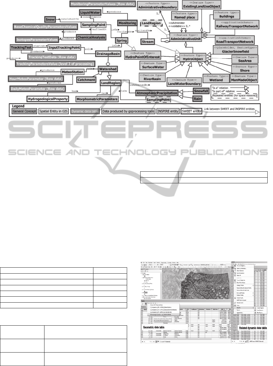
Figure 2: Conceptual reference model used for the GIS.
3.1.2 The Construction of an Interoperable
Geodatabase for ALIRHYS Data
On the harmonised base maps some original data
were produced. These have been mainly structured
following the part of the model designed on the
SWEET ontology. Entities with spatial consistency
have been archived as feature classes in a
geodatabase, while the entities mainly represented by
dynamic data tables are managed in a related external
database.
Using ESRI tools, a geodatabase is created in
ArcGIS. This is useful in order to define the static
entities of the system, to establish relationships and
topological rules between them and to impose
constraints including taxonomies and subtype
definition (tables 1-3).
Table 1: Entities (feature classes) of the geodatabase.
Springs Points
MeteoStations Points
SamplingPoints Points
InputTrackingPoints Points
Stream Points
LandRegion with HydrogeologicalProperties Polygon
DrainageBasin Polygon
Table 2: Relationship classes of the geodatabase.
S_Comparison_MS
Relation Springs - MeteoStations
1-n relation
S_Comparison_SP
Relation Springs - SamplingPoints
n-n relation
S_Comparison_SS
Relation Springs - Streams
n-1 relation
Through these associations it is possible to query
and access the data tables in a cross-referenced way
for easy comparison.
Table 3: Topology rules stated in the geodatabase.
SamplingPoints Must be Properly Inside - LandRegion
Spring Must be Properly Inside – DrainageBasin
The external database is defined in MS Access for
the representation of the dynamic entities in Table 4
(for which extensive records are needed). These are
represented in violet in the reference conceptual
model. Once the tables are related to the geodatabase
feature classes, they can be queried; it is then possible
to carry out analysis and statistics on them while also
considering their spatial reference (Fig.3). The
updating of the tables in the external software is
automatically translated to the GIS.
Figure 3: Example of resulting GIS with related dynamic
tables.
ASemanticGeodatabaseforEnvironmentAnalysis-Extraction,ManagementandSharingofEarthandWaterInformation
inGIS
217
Some difficulty is encountered in the limited
compatibility of the two software (ESRI ArcMap and
MsAccess) in their most recent versions, and by the
limitations on data recording for memory occupation
reasons. Therefore, in subsequent projects we will use
open-source platforms to work towards general
interoperability and better performance.
The data are then exported and published on a
WebGIS, which can be accessed from
www.polito.it/ALIRHYS for viewing the data;
downloading is available through the Web Map
Service (WMS), Web Coverage Service (WCS) and
Web Feature Service (WFS). Since the data are
semantically structured in a known and shared model,
it will be easier to correctly interpret them and.
On the other hand, the implemented structures can
be extracted from both software programs as an XML
file (with or without data) and can be shared and
easily imported by other users in the same software
for obtaining similar researches and comparable data.
The XML files are also shared on the project web site
to facilitate the use of the same method.
Table 4: Dynamic data tables stored in the external DB.
DailyMeteoParameters (Row data)
HourMeteoParameters (Row data)
MonitoringParameterValues (Row data) on Springs
IsotopesParametersValues on SamplingPoints [LiquidWater]
IsotopesParametersValues on SamplingPoints [Snow]
BaseChemicalQualityParametersValues on SamplingPoints
[LiquidWater]
BaseChemicalQualityParametersValues on SamplingPoints
[Snow]
IsotopesParameterValues on Springs [LiquidWater]
BaseChemicalQualityParametersValues on Springs
[LiquidWater]
MonitoringParameterValues (Row data) on Streams
TrackingTestsData (Row data)
TrackingParametersValues (Level 2 of processing)
3.2 Geoprocessing Tools of GIS for
Subterranean Resources Analysis
The other important capability of GIS is represented
by the geoprocessing algorithms, which can be used
for analysing terrain models in order to extract
important information for the interpretation of the
ground, and, in this case, for the study of water
resources.
This capability has been used for the automatic
extraction of morphologic maps for the study of
flows. Moreover, the extracted maps together with
some data derived from satellite imagery have been
used for estimating the snow volume in the study area
in particular periods. This can be useful in order to
manage the springs’ water by foreseeing the possible
flow rate in the snow fusion period.
The algorithms implemented in GIS management
software are able to extract a number of morphologic
and hydrologic data, starting primarily from the
DTM. This can be extremely useful when discussing
the geological aspects and water flows. In Figures 4-
6 there are some examples of information extracted
by a simple DTM. The processed objects correspond
to the pink entities of the conceptual model.
Figure 4: Morphometric parameters.
Figure 5: Catchment computed with the DTM as input file
(in black). The stream’s location appears, as visible from
the comparison with its complement in the digital map (in
red).
Some of these maps, such as the contour, aspect
and slope maps, are simply extracted by the DTM;
other algorithms analyse these basic maps to produce
modelling maps of flow dynamics that permit
researchers to locate the rivers, basins and other such
features. This can help in the hydrologic and
morphologic analysis. Another interesting tool
permits the calculation of groundwater flow, starting
from the DTM, the surface model of the aquifer, and
GISTAM2015-1stInternationalConferenceonGeographicalInformationSystemsTheory,ApplicationsandManagement
218

some other data. This could an interesting avenue of
future work linked to this project.
Figure 6: Sink watershed, allowing for the isolation and
visualization of each basin for conducting more specific
analysis on the hydric resources (tracking test hypotheses,
rain and snow monitoring, pollution source monitoring,
etc.).
4 CONCLUSIONS
Modelling the conceptual schema of a GIS using
affirmed ontology makes the information less
ambiguous, and data could be more easily sharable on
the web in line with the goals of the Semantic Web.
Using the integration of different application field
ontologies makes it possible to exhaustively represent
the environmental information, which traditionally
has been an enormous part of documentation and
monitoring data; this data is inherently related to the
Earth’s surface, a geometric object.
The GIS conceptual model includes several kinds
of data: geometric vector data, dynamic data and
raster datasets. It is the precondition for real
integrated management of all these kinds of data,
even if in this paper this work is still quite incomplete.
Future goals will include the automatic
implementation of such structures to achieve a unique
framework for data sharing. Some limits of the
system built are surely in the software used, because
these programs do not include some essential
characteristics of the ontological models. For
example, an ORDBMS (Object-Relational Database
Management System) such as PostgreSQL could
better manage both the geometric and the dynamic
data by also using some object-oriented properties
that are extremely useful for expressing the object’s
structure.
Such approaches could be worse for the usability
by inexpert users. This problem would be solved by
managing the data directly on the web, through some
user-friendly interfaces, even with a greater
requirement for informatics contribution. On the
other hand, this could effectively be a step towards
the realization of the Semantic Web’s aims of sharing
structured data and processing services.
Moreover, a limit to interoperability is the use of
commercial software, chosen for the user-friendly
interfaces and widespread adoption; these programs
work mainly with their own formats. In subsequent
studies, this issue will be solved through the use of
open source and self-integrated software.
Furthermore, it is well-known that GIS data
management is used for the geoprocessing and data-
modelling of archived data, in particular for
environment applications. The relationship between
GIS and environmental modelling has been studied
from a semantic point of view as well (Fallahi et al.,
2008; Kiehle et al., 2006; Argent, 2004). This will be
object of future in-depth analysis, with an ultimate
goal of a truly complete and integrated system.
ACKNOWLEDGEMENTS
This project ALCOTRA ALIRHYS was possible due
to Prof. Geol. Bartolomeo Vigna.
REFERENCES
Afflerbach, S, Illert, A, and Sarjakoski, T, 2004. The
Harmonisation Challenge of Core National
Topographic Databases in the EU-Project GiMoDig. In:
International Archives of Photogrammetry, Remote
Sensing and Spatial Information Sciences,
XXXV(B4/IV), pp.129-134.
Bellone, T., Dabove, P., Manzino, A. M., Taglioretti, C.,
2014. Real-time monitoring for fast deformations using
GNSS low-cost receivers. In: Geomatics, Natural
Hazards & Risk, pp. 1-13. ISSN 1947-5705
Decker, S., Melnik, S., van Harmelen, F., Fensel, D., Klein,
M., Broekstra, J., Erdmann, M., Horrocks, I., 2000. The
Semantic Web: the Roles of XML and RDF. In: IEEE
Internet Computing, 15, 3, 2000, 63-74.
DiGiuseppe, N., Pouchard, L. C., Noy, N., 2014. SWEET
ontology coverage for earth system sciences. In: Earth
Sci Inform. DOI: 10.1007/s12145-013-0143-1.
Disabato, F., 2010. Remote sensing data analysis for
environmental and humanitarian purposes. The
automation of information extraction from satellite
data. PhD Thesis, Politecnico di Torino.
Dozier, J., Elder, K., Michaelsen, J., 1991. Snow
accumulation and distribution in an alpine watershed.
In: Water Resources Research, 27, 7, pp. 1541-1552.
Fallahi, G. R., Frank, A. U., Mesgari, M. S., Rajabifard, A.,
ASemanticGeodatabaseforEnvironmentAnalysis-Extraction,ManagementandSharingofEarthandWaterInformation
inGIS
219

2008. An ontological structure for semantic
interoperability of GIS and environmental modelling.
In: International Journal of Applied Earth Observation
and Geoinformation 10, Elsevier, pp.229-246.
Fonseca, F., Egenhofer, M., Davis, C., Camara, G., 2002.
Semantic granularity in ontology-driven geographic
information systems. In: MAI Annals of Mathematics
and Artificial Intelligence 36 (1e2).
Freksa C., Barkowsky T., 1996. On the relation between
Spatial Concepts and Geographic Objects. In: P.
Burrough & A. Frank, Geographic objects with
indeterminate boundaries, London. Taylor & Francis,
pp. 109-121.
Gröger, G., Kolbe, T. H., Czerwinski, A., Nagel, C., 2008.
OpenGIS City Geography Markup Language
(CityGML) Encoding Standard. Open Geospatial
Consortium Inc., OGC 08-007r1.
Kiehle, C., Greve, K., Heier, C., 2006. Standardized
geoprocessing - taking spatial data infrastructures one
step further. In: The 9th AGILE Conference on
Geographic Information Science, Visegràd, Hungary.
Mennis, J. L., 2003. Derivation and implementation of a
semantic GIS data model informed by principles of
cognition. In: Computers, Environment and Urban
Systems 27 (2003), pp. 455-479.
Noardo, F., Lingua, A., Aicardi, I., Vigna, B., 2015.
Cartographic data harmonisation for a cross-border
project development. In: Applied Geomatics.
Pundt, H., Bishr, Y., 2002. Domain ontologies for data
sharing – an example from environmental monitoring
using field GIS. In: Computers & Geosciences, 28(1),
pp. 95-102.
Raskin, R., Pan M., Mattmann C., 2004. Enabling semantic
interoperability for earth science data. In: 4th NASA
Earth Science Technology Conference.
http://inspire.ec.europa.eu/data-
model/approved/r4618-ir/html/
Scholl, M., Voisard A., 1992. Object-oriented database
systems for geographic applications: an experiment
with O2. In: Proc. Int. Workshop on Database
Management Systems for Geographical
Applications,(Capri, 1991), Springer.
Tóth, K, Smits, P, 2007. Infrastructure for spatial
information in Europe (INSPIRE): from cartography to
spatial objects and network services, In: Proceedings of
the 23rd Cartographic Conference – Cartography for
everyone and for you, Roskartografija, p.1-11.
Tschirner, S, Scherp, A, Staab, S, 2011. Semantic access to
INSPIRE. In: Terra Cognita 2011 Workshop
Foundations, Technologies and Applications of the
Geospatial Web (p. 75).
Waters, J., Powers, B. J., Ceruti, M. G., 2009. Global
Interoperability Using Semantics, Standards, Science
and Technology (GIS3T). In: Computers Standards &
Interfaces, 31, Elsevier, pp. 1158-1166.
Worboys, M. F., Duckham M., 2004. GIS: A computing
perspective. CRC press.
GISTAM2015-1stInternationalConferenceonGeographicalInformationSystemsTheory,ApplicationsandManagement
220
