
Analysis of Service-Oriented Infomobility System and Architecture
Model
Stanislav Simeonov
1 a
, Ekaterina Gospodinova
2 b
, Ivan Torlakov
2
and Asen Iliev
1 c
1
Department of Computer Systems and Technologies “Prof. Dr Assen Zlatarov” University, Burgas, Bulgaria
2
Department of Electronics, Automation and Information Technologies, Technical University of Sofia, Sliven, Bulgaria
fi
Keywords:
Infrastructure, Multiples Theory, Multimodality, Ontology, Travel Planning.
Abstract:
This paper examines the development of a method and a model for building a service-oriented information
mobility system that improves the quality of user service by using open data and services in travel planning,
taking into account the formulated requirements, the semantic operability of the services and changes in their
behavior depending on alterations in the system. In contrast to existing systems, a multimodal route planning
method for local, regional, national and international trips with public and personal transport has been de-
veloped, which uses the methods of set theory, ontology management, context management, system analysis,
privacy protection, geosearch and recommendation generation, with the ability to merge applications.
1 INTRODUCTION
In the course of analyzing the problems of road in-
frastructure development, scientists have derived the
concept of comfortable living. One of the charac-
teristics is the ability to move comfortably. It can
be concluded that a developed transport network and
the presence of convenient pedestrian infrastructure
are essential components (Adomavicius et al., 2005).
To improve the efficiency of urban transport planning
management, a comprehensive analysis of the exist-
ing transport network is required, which includes all
available modes of transport and the existing road in-
frastructure. The mix of modes of transport used in
a city largely depends on its size and characteristics.
For a small town, the choice of modes of transport is
usually not a particular problem. Most of the needs
of city dwellers can be met by individual transporta-
tion - on foot, by bicycle or by car. For cities with a
low level of motorization or with a large number of
inhabitants, public transport services must be devel-
oped. Thus, small cities with a high level of motor-
ization are the only place where a unimodal car-road
system supplemented by pedestrian infrastructure can
be considered adequate and efficient. As the size of
the city increases, so does the need for public trans-
a
https://orcid.org/0000-0002-8145-405X
b
https://orcid.org/0000-0001-9083-7135
c
https://orcid.org/0000-0001-7813-3688
port, which has a significant load capacity. At the
same time, a number of problems arise related to the
use of cars within the city, excessive consumption of
available territorial resources and negative external-
ities. Therefore, such cities should introduce a bal-
anced transport system.
The goal of this work is to build a service-oriented
infomobility system that provides users with access
to multimodal, dynamic, personalized information,
tailored to context services, to increase the mobil-
ity and ease of movement of users when planning a
trip and during travel. To provide knowledge, based
on a conceptualization that includes a description of
a set of objects and concepts, knowledge and rela-
tionships between them, based on the use of services
as sources of information and the way they are pro-
cessed. The approach is based on the following prin-
ciples arising from the requirements: openness of
data and services, use of ontologies, distributed archi-
tecture, user orientation, use of contextual informa-
tion, self-contextualization of services, real-time op-
eration, multimodality of routes, information privacy
for the user. Following these principles will satisfy the
basic requirements and provide the user with quality
services to ensure their mobility.
Simeonov, S., Gospodinova, E., Torlakov, I. and Iliev, A.
Analysis of Service-Oriented Infomobility System and Architecture Model.
DOI: 10.5220/0011902000003612
In Proceedings of the 3rd International Symposium on Automation, Information and Computing (ISAIC 2022), pages 57-62
ISBN: 978-989-758-622-4; ISSN: 2975-9463
Copyright
c
2023 by SCITEPRESS – Science and Technology Publications, Lda. Under CC license (CC BY-NC-ND 4.0)
57

2 RESEARCH AND PROJECTS IN
THE FIELD OF
INFOMOBILITY
Navitime is a mobile navigation service available in
Japan (Arikawa et al., 2007). Navitime provides users
with route calculation and guidance services by in-
tegrating several modes of transportation: walking
routes, personal vehicles, trains, taxis and airplanes.
Navitime combines mobility information provided by
disparate data sources by converting it into four com-
mon formats. The publicly available documentation
makes no direct reference to Navitime’s adherence to
existing mobility information storage and exchange
standards.
The iTransit Integration Environment is the foun-
dation for a multi-layered intelligent system architec-
ture designed to integrate modern and traditional in-
telligent transportation vehicles (Brennan and Meier,
2007). It is based on a layered object data model. The
model contains the spatial and temporal aspects of
transport and traffic data and is a unified mechanism
for querying and processing information from hetero-
geneous transport systems. It also includes global in-
formation layers containing the region’s geography
and transportation network. Data exchange between
the systems making up the iTransit architecture is
based on the use of CORBA technology and web ser-
vices.
Xiang (Xiang et al., 2007a; Xiang et al., 2007b)
describes the design principles adopted to implement
the Information System for passengers on highways
in China. The HTIS architecture is aimed at providing
an environment that enables the interaction between
distributed heterogeneous systems. The focus of con-
textual information collection is on highway monitor-
ing and control information, while end-user-focused
contextual elements (e.g., location, activity, etc.) are
not considered. The emphasis is on the integration
model of heterogeneous and distributed information
systems based on multi-level architecture, common
protocols and data formats.
Arktrans is the environment for multimodal intel-
ligent transport systems in Norway (Natvig and West-
erheim, 2007). Its aim is to create a common perspec-
tive on the transport problem area for all modes of
transport (road, sea, rail and air) in terms of standard
functions and interfaces for interaction between dif-
ferent transport systems. The operation of the system
is aimed at assisting users in planning a trip, while the
integration of the navigation service is not realized.
Lol@, the local assistant, is a prototype UMTS
guide developed as part of a joint project at the Vienna
Research Center for Telecommunications (Umlauft
et al., 2002). Lol@ is a location-based travel service
that implements SIP (Session Initiation Protocol) and
the OCA/Parlay standards. It provides tourists with
navigation services for predetermined routes. Lol@
uses different positioning methods: GPS, mobile net-
work based and manual location input by users.
The main disadvantage of the described services is
the incomplete geographical coverage. Although gen-
eral maps are available worldwide, their details and
the list of services provided vary greatly by region.
For example, CIS and Asian users do not have access
to many events on the map (only traffic is shown), not
all cities have a traffic schedule, or not all available
transport is covered. This situation is due to the fact
that both services use third-party services to obtain
additional information, and data processing for their
own services is carried out in a semi-automatic mode
(Verma et al., 2012).
3 A CONCEPTUAL MODEL OF A
SERVICE-ORIENTED
INFOMOBILITY SYSTEM
In order to develop an infomobility system, the fol-
lowing requirements can be defined that its architec-
ture must meet: support of a heterogeneous environ-
ment of mobile devices; scalability; addition of new
elements that provide new functions and are avail-
able to a wide range of users; free interaction; in the
development of the system, ontology must be used,
which provides the following advantages: it makes
the system interoperable, reduces the development
complexity associated with the variety of technolo-
gies used, and facilitates the interaction between peo-
ple and computer systems; services must be acces-
sible through various wireless technologies such as
wireless LAN or Bluetooth.
The developed system should be focused on: the
use of open data, an open information system includ-
ing transport services, that provide information de-
pending on the user’s location (weather, attractions),
information sharing mechanisms and mechanisms to
ensure semantic interoperability. This requirement
also defines the use of a distributed architecture to
organize the cooperation of services. This approach
makes it possible to support a wide variety of devices
and information services. The addition of new func-
tionality is carried out by starting a new service, with-
out the need for a substantial redesign of the system.
It is also necessary to support the planning of routes
compatible with different vehicles and for individual
modes of transport, as well as to ensure, if necessary,
ISAIC 2022 - International Symposium on Automation, Information and Computing
58

a change of modes of transport during the route (Xi-
ang et al., 2007a; Yudenok and Krinkin, 2012).
User preferences can be set by creating a user pro-
file that reflects the basic characteristics inherent to
the user. Thanks to the use of smart spaces technol-
ogy, it is possible to define a user profile in the form
of an ontology.
The system must provide real-time information
and support (traffic information, timely detection of
traffic jams, search for objects on a map, up-to-date
information on how objects work).
In the process of operation, the infomobility sys-
tem must take into account the current situation in or-
der to provide support options that are most suitable
for the user at a given moment. For example: recom-
mending objects on the map depending on the time (it
is better to visit the park in sunny weather and wait out
the rain in the nearest cafe, which has many positive
reviews).
Unlike the centralized architecture, the distributed
one introduces additional tasks related to ensuring the
security of users’ personal information. The advan-
tage of a centralized infrastructure is that all informa-
tion is processed in a single, self-contained environ-
ment. This allows to create a secure channel through
which all processed information will be transmitted
without leaving the environment. All users are iso-
lated from each other, which prevents unauthorized
access to their personal data. In the case of a dis-
tributed architecture, it is necessary to send and col-
lect data for several services at once, some of which
may be provided by a third party (for example, col-
lecting photos of given coordinates). In this regard, it
is necessary to further develop mechanisms to ensure
the safety of the users personal.
4 MODEL OF
SERVICE-ORIENTED
INFOMOBILITY SYSTEM
(SOIS)
As a result of the analysis of publications on infomo-
bility systems, the main needs of potential users of
the developed system were also identified. The per-
formed analysis made it possible to formulate typical
user situations for working with the system, united in
a general model of SOIS (Figure 1). Individual situa-
tions can be grouped into three large groups:
1) Route planning. The system performs route
planning, if necessary, combining several modes of
transport while following the route, taking into ac-
count the schedule of public transport and providing
the possibility of joint trips with private vehicles. This
allows to reduce the waiting time at the transfer points
and to plan the route in real time.
2) Search for objects. The system provides infor-
mation support to the user when planning a route be-
tween objects on the ground. In addition to the route,
the user is provided with context-sensitive recommen-
dations for the nearest points of interest, ranked based
on feedback from other users using collaborative fil-
tering.
3) Visualization of the context. The user’s de-
vice displays information about the current situation
around him: the current time, the location of the
means of transport on the routes of public transport,
traffic jams and others.
Each work situation requires the use of several ser-
vices, which allows the large task to be divided into
component parts that are executed in parallel. Context
visualization involves gathering information about the
current situation from open data sources and display-
ing the gathered information on the user’s device. It
may include: temperature and weather conditions that
provide weather information depending on the spec-
ified location, object list, context update notification,
user service, object search service, recommendation
generation service, search service for site informa-
tion, route planning service, service interaction space,
additional site information, routes to sites, site rat-
ings, current road network status, road events, loca-
tion of vehicles on public transport routes. In formal-
izing knowledge about the problem domain of the ser-
vice described by the proposed ontology, the means
of object-oriented constraint networks are used (Lev-
ashova et al., 2021). In accordance with this formal-
ism, an ontology (A) is represented in the following
form:
A = ⟨O, Q, D, R⟩, (1)
where O is the set of classes representing ob-
jects; Q is a set of class attributes in which there
are three subgroups that describe: parameters of the
physical environment P = p
1
, ..., p
n
; results of in-
formation processing and other information compo-
nents, V = v
1
, ..., v
m
; user social characteristics S =
s
1
, ..., s
l
, n, m, l ∈ N , where Q = P, V, S; D is a set
of domains, regions of valid attribute values; R is a
set of relations by which classes are related. Rela-
tionships describe: class taxonomy, class hierarchy,
inheritance, properties, etc. When forming the ab-
stract context of the current situation, from the sets
in the ontology, corresponding subsets are formed,
which include only those elements of the original that
are used to describe the current situation. At the
same time, in an ontological model, many services are
Analysis of Service-Oriented Infomobility System and Architecture Model
59
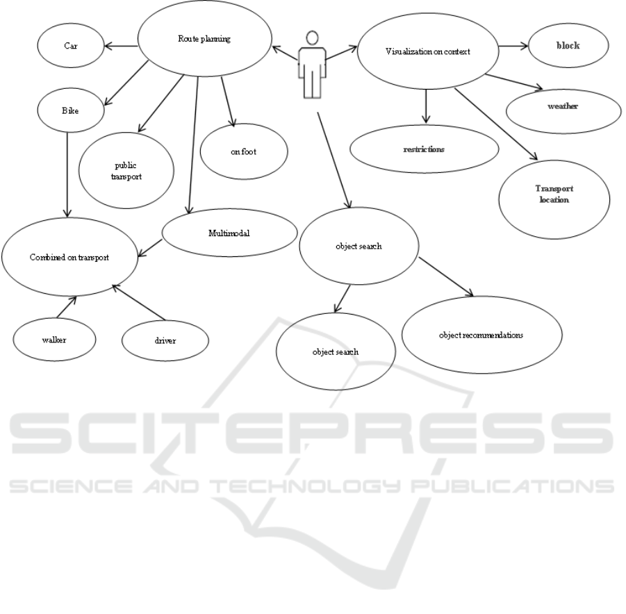
Figure 1: Situation model diagram.
added that can provide knowledge and information to
form the context and services capable of performing
certain actions with the existing knowledge and infor-
mation. Thus, an abstract context can be expressed
as:
Context
abs
(C, T
abs
) = ⟨O
abs
,
Q
abs
, D
abs
, R
abs
, W S
abs
, T
abs
⟩,
(2)
where C is the simulated situation; O
abs
⊆ O is
the set of classes needed in the first case to simulate
situation S; Q
abs
⊆ Q is the set of attributes of class
O
abs
; D
abs
⊆ D is a set of domains Q
abs
; R
abs
⊆ R is
the set of constraints involved in an abstract context;
W S
abs
is a set of web services that model information
resource functions that assign values to attributes Q
abs
and can perform processing of available information,
W
a
S
bs
⊆ W S, where W S is the set of registered web
services; T
abs
is the predicted model adequacy time.
In order to be able to obtain information about the
current situation involved in the system, relationships
are established between ontologies and sources indi-
cating from where the corresponding property values
of an object can be obtained. As information is re-
ceived from other services, values and attributes are
assigned to the classes of the abstract context and the
formation of the operational context. The operational
context Context
top
is a model of the current situation
described by an abstract context Context
abs
, with at-
tribute values Q
abs
. This model can be interpreted as a
problem for the constraint satisfactio. The application
context model is represented as:
Context
top
(C, t) = ⟨O
op
, Q
op
,
D
op
, R
op
, W S
op
, T
op
, δT ⟩,
(3)
where t is the current time.
For the context of the user and the multimodal
travel planning service, which are part of the infomo-
bility system, an ontology that most fully meets the
specifics of the relevant problem area has been devel-
oped. In this way, the general ontology of the system
for each situation, if necessary, can be composed of
private ontologies of services formed taking into ac-
count the current situation. In addition, a description
of the ontology used on user devices to provide infor-
mation to system services is given.
ISAIC 2022 - International Symposium on Automation, Information and Computing
60
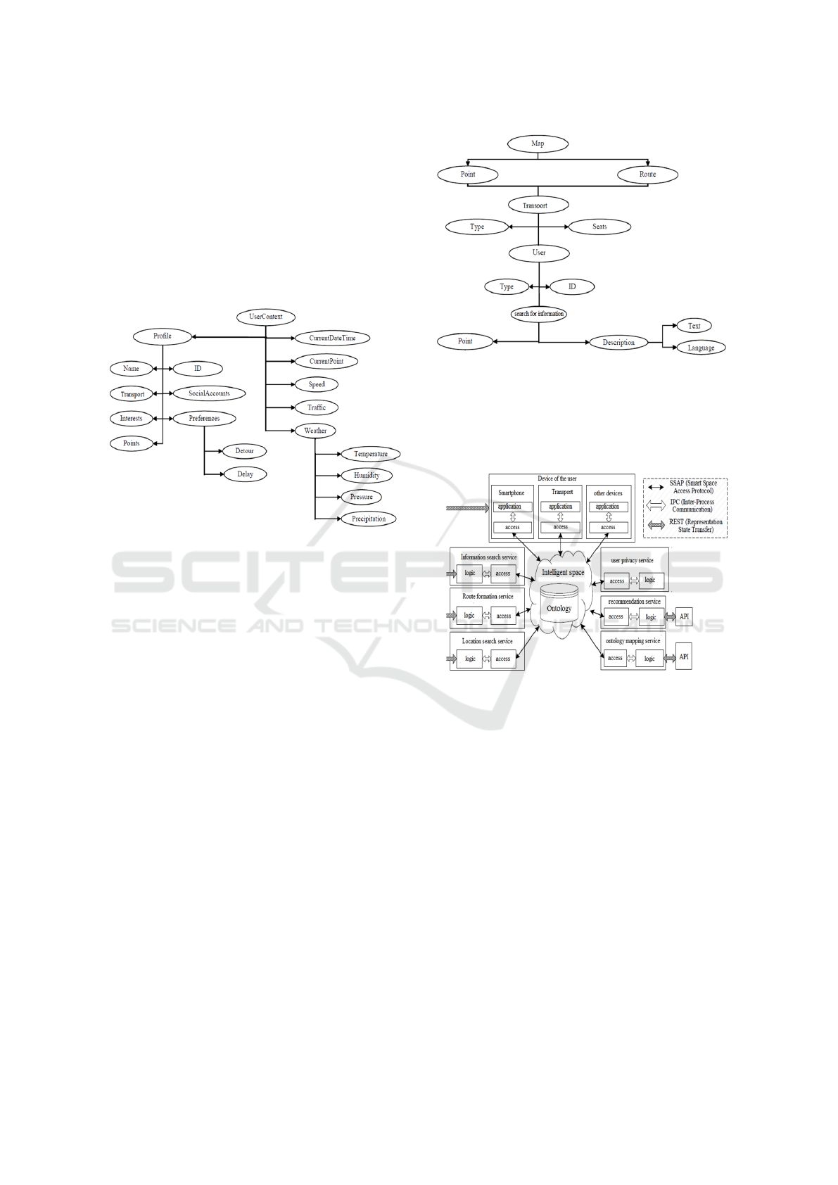
5 USER CONTEXT ONTOLOGY
AND MULTIMODAL TRAVEL
PLANNING SERVICE
With the help of the user context in the infomobility
system, its main characteristics and the state of the en-
vironment are described. This information is used by
system services to provide personalized support based
on the current situation (Figure 2).
Figure 2: User Context Ontology.
It consists of two parts: information provided by
the user himself, his profile (name, preferences, car
ownership, key locations on the map, etc.) and au-
tomatically collected information about the environ-
ment (current location, traffic speed, weather, etc..).
User context includes attributes obtained from the
sensors of the user’s devices and from the information
provider’s services.
The problem area of the route planning service
covers tasks related to the use of map, time and per-
sonal information for route planning with different
modes of transport. In this regard, the ontology of
this service should consider objects related to the rep-
resentation of map information, vehicle schedule in-
formation, vehicle characteristics, and user character-
istics figure 3.
6 INFOMOBILITY SYSTEM
ARCHITECTURE
The architecture of the infomobility system is shown
in Figure 4. According to the developed model, a
service-oriented approach was used to build the ar-
chitecture. The sources and processors of information
and knowledge are the services installed on the user’s
devices and on the servers that ensure the operation of
Figure 3: Map Context Ontology.
the infomobility system. The interaction of services
is carried out through the ”blackboard” architectural
model, implemented based on intelligent space tech-
nology (Hu et al., 2005; Hu et al., 2008).
Figure 4: Service Oriented Architecture
7 CONCLUSIONS
In this work, the authors have proposed an approach
to building an infomobility system based on the use
of services as sources of information and knowledge.
The approach is based on the following requirements:
openness of data and services, use of ontologies, dis-
tributed architecture, user orientation, use of contex-
tual information, self-contextualization of services,
real-time operation, multimodality of routes, user in-
formation privacy. Following these principles will
satisfy the basic requirements and provide the user
with quality services to ensure their mobility. One
of the main advantages of an ontology is its reusabil-
ity. Self-contextualization of services is based on this,
i.e., the ability to self-describe and change the con-
text, which can be changed by expanding the ontol-
Analysis of Service-Oriented Infomobility System and Architecture Model
61

ogy by including new concepts in it or narrowed by
excluding unnecessary ones. For each service, an on-
tology is defined that most fully describes the relevant
subject area. Services can change the knowledge de-
scription model to better fit the current situation, al-
lowing them to respond adequately to its change. The
method used to build the core services of the infomo-
bility system is to be presented in the future.
ACKNOWLEDGEMENTS
This research was funded by the European Regional
Development Fund through the Operational Pro-
gram “Science and Education for Smart Growth” un-
der contract UNITe No BG05M2OP001–1.001–0004
(2018–2023).
REFERENCES
Adomavicius, G., Sankaranarayanan, R., Sen, S., and
Tuzhilin, A. (2005). Incorporating contextual infor-
mation in recommender systems using a multidimen-
sional approach. ACM Transactions on Information
Systems, 23(1):103–145.
Arikawa, M., Konomi, S., and Ohnishi, K. (2007). Nav-
itime: Supporting pedestrian navigation in the real
world. IEEE Pervasive Computing, 6(3):21–29.
Brennan, S. and Meier, R. (2007). STIS: Smart travel plan-
ning across multiple modes of transportation. In 2007
IEEE Intelligent Transportation Systems Conference.
IEEE.
Hu, W., Jian, N., Qu, Y., and Wang, Y. (2005). Gmo: A
graph matching for ontologies. volume 156.
Hu, W., Qu, Y., and Cheng, G. (2008). Matching large
ontologies: A divide-and-conquer approach. Data
Knowl. Eng., 67:140–160.
Levashova, T. V., Smirnov, A. V., Pashkin, M. P., and Pono-
marev, A. V. (2021). Conceptual framework of intelli-
gent decision support based on user digital life traces
and ontology-based user categorisation. Journal of
Physics: Conference Series, 1801(1):012005.
Natvig, M. and Westerheim, H. (2007). National multi-
modal travel information – a strategy based on stake-
holder involvement and intelligent transportation sys-
tem architecture. IET Intelligent Transport Systems,
1(2):102.
Umlauft, M., Pospischil, G., Niklfeld, G., and Michlmayr,
E. (2002). Lol@, a mobile tourist guide for umts. J.
Inf. Technol. Tour., 5:151–164.
Verma, S., Kumar, S., and Singh, M. (2012). Comparative
analysis of role base and attribute base access control
model in semantic web. International Journal of Com-
puter Applications, 46:1–6.
Xiang, Q., Ma, Y., Lu, J., Xie, J., and Sha, H. (2007a).
Framework design of highway traveller information
system of jiangsu province in china. IET Intelligent
Transport Systems, 1(2):110.
Xiang, Q., Ma, Y., Lu, J., Xie, J., and Sha, H. (2007b).
Framework design of highway traveller information
system of jiangsu province in china. IET Intelligent
Transport Systems, 1(2):110.
Yudenok, K. and Krinkin, K. (2012). Distributed service
environment (smart spaces) security model develop-
ment. In 2012 12th Conference of Open Innovations
Association (FRUCT). IEEE.
ISAIC 2022 - International Symposium on Automation, Information and Computing
62
