
3D Mask-Based Shape Loss Function for LIDAR Data
for Improved 3D Object Detection
R. Park and C. Lee
Dept. of Electric and Electronic Engineering, Yonsei University, Republic of Korea
Keywords: LIDAR, 3D Modelling, Shape Loss, Objection Detection, Autonomous Driving, Adaptive Ground ROI
Estimation.
Abstract: In this paper, we propose a 3D shape loss function for improved 3D object detection for LIDAR data. As the
LiDAR (Light Detection And Ranging) sensor plays a key role in many autonomous driving techniques, 3D
object detection using LiDAR data has become an important issue. Due to inaccurate height estimation, 3D
object detection methods using LiDAR data produce false positive errors. We propose a new 3D shape loss
function based on 3D masks for improved performance. To accurately estimate ground ROI areas, we first
apply an adaptive ground ROI estimation method to accurately estimate ground ROIs and then use the shape
loss function to reduce false positive errors. Experimental shows some promising results.
1 INTRODUCTION
In autonomous driving techniques, object detection is
a key element (Simony, 2018; Shi, 2019; Lang,
2019). Although vision-based object detection
methods have several advantages in terms of cost and
flexibility (Wang, 2021; Bochkovskiy, 2020; Wang,
2022), they tend to produce errors under poor
conditions such as backlighting, dark scene, and
sudden illumination changes (Xu, 2020; Jeong, 2021;
Xu, 2020). On the other hand, LiDAR-based 3D
object detection methods provide more reliable
performance under those challenging conditions.
However, the LiDAR-based methods, which use the
entire point cloud (PC), also showed some limitations
in real-time processing(Shi, 2019). Since the MV3D
method was proposed (Chen, 2017), many
researchers have studied 3D object detection methods
using BEV(Bird’s Eye View) (Yang, 2018; Simony,
2018). However, converting 3D information of
LiDAR data to 2D BEV, some features were lost,
which may produce some errors. When BEV images
are produced, the height information is permanently
lost. From the BEV images, the ground ROI (region
of interest) is estimated. Since the goal is to estimate
3D boxes of targets (cuboids), the height is estimated
as the average height values of the PC sample points
within the cuboid. Fig. 1 illustrates this procedure.
Fig. 1(a) is a point cloud and Fig. 1(c) shows a BEV
image with 2D bounding boxes. Fig. 1(b) is the
estimated 3D object cuboids. However, this
procedure tends to produce many false positive (FP)
errors. Fig. 2 shows such false positive errors of the
complex YOLO algorithm (Simony, 2018).
(a)
(b)
(c)
Figure 1: Examples of LiDAR data. (a) point cloud, (b) 3D
object cuboid, (c) BEV image with 2D bounding boxes.
In order to reduce this kind of false positive error, we
propose to use 3D shape masks to compute a 3D
shape loss function for improved 3D object detection
for LIDAR data.
Park, R. and Lee, C.
3D Mask-Based Shape Loss Function for LIDAR Data for Improved 3D Object Detection.
DOI: 10.5220/0011966800003479
In Proceedings of the 9th International Conference on Vehicle Technology and Intelligent Transport Systems (VEHITS 2023), pages 305-312
ISBN: 978-989-758-652-1; ISSN: 2184-495X
Copyright
c
2023 by SCITEPRESS – Science and Technology Publications, Lda. Under CC license (CC BY-NC-ND 4.0)
305

(a)
(b)
(c)
(d)
Figure 2: Examples of false positive errors of complex
YOLO (top: ground truth, bottom: false positive errors of
the complex YOLO algorithm). The red cuboids represent
cars whereas the green cuboids represent pedestrians.
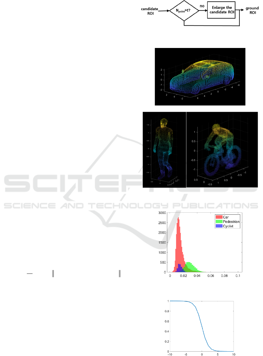
Figure 3: Flowchart of the proposed method.
Figure 4: Incorrect 3D localization examples (top: ground
truth, bottom: outputs of the complex YOLO algorithm).
VEHITS 2023 - 9th International Conference on Vehicle Technology and Intelligent Transport Systems
306
2 PROPOSED METHOD
Fig. 3 shows a flowchart of the proposed method. First,
we apply an adaptive ground ROI estimation method,
which produces a more accurate ground ROI
estimation. Then, we estimate a target cuboid. Finally,
we use 3D masks to compute a shape loss function.
2.1 Adaptive Ground ROI Estimation
We observed that some errors were caused by
inaccurate estimation of ground ROIs in BEV images.
Fig. 4 shows some inaccurate estimations of ground
ROIs when the complex YOLO algorithm (Simony,
2018) was used. To better estimate ground ROIs, we
propose an adaptive ground ROI estimation method
(Fig. 5). First, we estimate an initial ROI and then
search neighbour areas to produce an improved
estimation using a ground prediction algorithm
(Pingel, 2013). With this adaptive ground ROI
estimation method, the incorrect localization errors
(incorrect ground ROI estimation) were noticeably
reduced as can be seen in Fig. 9.
2.2 3D Shape Loss Function Based on
3D Masks
In conventional methods, the cuboid height is
estimated based on the average value of LiDAR
samples (z-direction). However, this estimation
method may produce some erroneous results. In
particular, it may produce some false positive errors
as can be seen in Fig. 2.
In order to solve this problem, we propose to use 3D
masks for the three major objects: car, pedestrian, and
cyclist. Fig. 6 shows the 3D masks used in this paper.
Using the LiDAR points within a candidate cuboid,
we computed the shape loss function as follows:
1
1
min( {reference point cloud} )
N
shape i
k
i
loss p
N
=
=−
where
i
p
is the i-th point of the candidate cuboid,
{referencepoint cloud}
is a set of the 3D mask points,
N is the number of points of the candidate cuboid. Fig.
7 shows the histogram of the shape loss function of
the three 3D masks.
In order to normalize the values of the shape loss
function, we used the following normalization
function so that the range is between 0 and 1:
1()
normalized
shape shape
loss sigmoid loss=−
.
Fig. 8 shows the graph of the normalization function.
Figure 5: Adaptive ground ROI estimation (N
p
: number of
points with the candidate ROI).
(a)
(b) (c)
Figure 6: 3D masks. (a) car, (b) pedestrian, (c) cyclist.
Figure 7: Histogram of the shape loss function of the three
3D masks.
Figure 8: Normalization function.
3D Mask-Based Shape Loss Function for LIDAR Data for Improved 3D Object Detection
307

Figure 9: Improved localization (ground ROI estimation) of the proposed adaptive ground ROI estimation method (top:
ground truth, middle: outputs of the complex YOLO algorithm, bottom: improved ground ROI estimation of the proposed
adaptive ground ROI estimation method.
VEHITS 2023 - 9th International Conference on Vehicle Technology and Intelligent Transport Systems
308

Figure 10: Improvement performance of the proposed method that uses the shape loss function with reduced false positive
errors (top: ground truth, middle: outputs of the complex YOLO algorithm, bottom: proposed method.
3D Mask-Based Shape Loss Function for LIDAR Data for Improved 3D Object Detection
309

Figure 11: Improvement instance segmentation of the proposed method.
VEHITS 2023 - 9th International Conference on Vehicle Technology and Intelligent Transport Systems
310
3 EXPERIMENTAL RESULTS
3.1 Dataset and Results
Experiments were performed using the KITTI
Dataset, which is widely used in 3D object detection
research, was used (Geiger, 2012).
The KITTI Dataset consists of 7481 images with
9 classes. We used 3 major classes (car, pedestrian,
and cyclist) for autonomous driving. We used 70% of
the KITTI dataset for training and the remaining 30%
for validation. Although the complex YOLO
(YOLOv2) was used, the prediction model was
designed using YOLOv4 (Bochkovskiy, 2020).
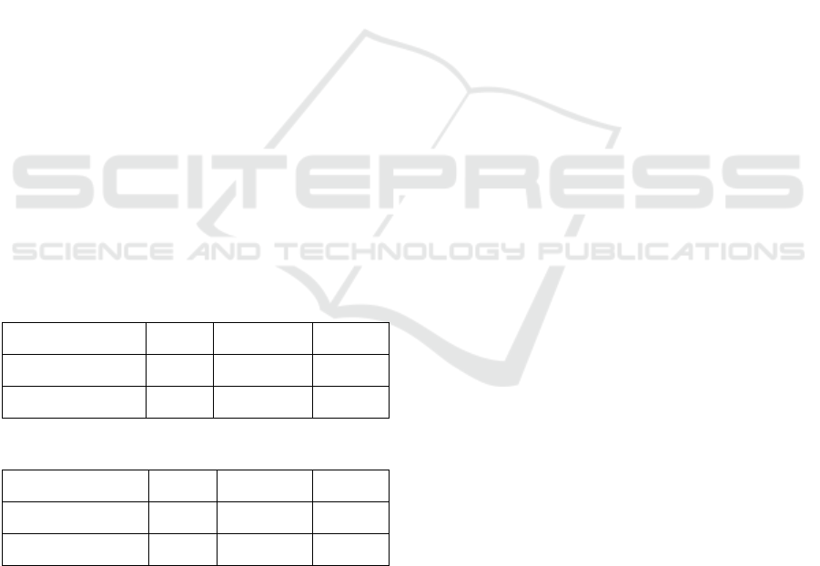
Tables 1-2 show the performance comparison
between the proposed algorithm and the complex
YOLO algorithm in terms of AOS (Average
Orientation Similarity) (Geiger, 2012) and AP
(Average Precision) (Everingham, 2010; Geiger,
2012). It is noted that both AP and AOS metrics
consider the result is correct if a predicted box
overlaps by at least 50% with a ground truth bounding
box. Thus, the metrics of Tables 1-2 may not fully
reflect more accurate bounding box estimations of the
proposed method.
Fig.10 shows some prediction output images
obtained by applying the proposed method and the
complex YOLO algorithm. Green cuboids represent
people, and red cuboids represent vehicles. It can be
seen that the proposed algorithm noticeably reduced
false positive errors.
Table 1: Performance comparison (AOS).
Model Car Pedestrian Cyclist
complex YOLO 0.729 0.406 0.573
Proposed 0.730 0.418 0.579
Table 2: Performance comparison (AP).
Model Car Pedestrian Cyclist
complex YOLO 0.780 0.413 0.582
Proposed 0.782 0.425 0.588
3.2 Instance Segmentation
Since the proposed method based on 3D masks can
produce accurate 3D boundaries, we can generate
accurate instance segmentation, whereas the
conventional methods can only produce 3D bounding
boxes (cuboids) that provide approximate 3D
locations of target objects. Fig. 11 shows some
instance segmentation results of the proposed
method.
4 CONCLUSIONS
The LiDAR sensor can provide important
information for 3D object detection in autonomous
driving methods. Using the LiDAR sensor, one can
overcome the reliability issues of vision-based
objection methods. However, 3D object detection
methods based on BEV images of LiDAR data have
some other problems such as inaccurate ground ROI
estimation and false positive errors. We propose to
use a 3D shape loss function based on 3D masks for
three major targets. Although experimental results
show some promising results, one can improve the
performance by using more diverse 3D masks.
ACKNOWLEDGEMENTS
This research was supported in part by Basic Science
Research Program through the National Research
Foundation of Korea (NRF) funded by the Ministry
of Education, Science and Technology (NRF-
2020R1A2C1012221).
REFERENCES
Bochkovskiy, A., Wang, C. Y., & Liao, H. Y. M. (2020).
Yolov4: Optimal speed and accuracy of object
detection. arXiv preprint arXiv:2004.10934.
Chen, X., Ma, H., Wan, J., Li, B., & Xia, T. (2017). Multi-
view 3d object detection network for autonomous
driving. In Proceedings of the IEEE conference on
Computer Vision and Pattern Recognition (pp. 1907-
1915).
Everingham, M., Van Gool, L., Williams, C. K., Winn, J.,
& Zisserman, A. (2010). The pascal visual object
classes (voc) challenge. International journal of
computer vision, 88(2), 303-338.
Geiger, A., Lenz, P., & Urtasun, R. (2012). Are we ready
for autonomous driving? the KITTI vision benchmark
suite. In 2012 IEEE conference on computer vision and
pattern recognition (pp. 3354-3361).
Jeong, Y. (2021). Predictive lane change decision making
using bidirectional long shot-term memory for
autonomous driving on highways. IEEE Access, 9,
144985-144998.
Lang, A. H., Vora, S., Caesar, H., Zhou, L., Yang, J., &
Beijbom, O. (2019). Pointpillars: Fast encoders for
object detection from point clouds. In Proceedings of
3D Mask-Based Shape Loss Function for LIDAR Data for Improved 3D Object Detection
311

the IEEE/CVF conference on computer vision and
pattern recognition (pp. 12697-12705).
Pingel, T. J., Clarke, K. C., & McBride, W. A. (2013). An
improved simple morphological filter for the terrain
classification of airborne LIDAR data. ISPRS Journal
of Photogrammetry and Remote Sensing, 77, 21-30.
Shi, S., Wang, X., & Li, H. (2019). Pointrcnn: 3d object
proposal generation and detection from point cloud. In
Proceedings of the IEEE/CVF conference on computer
vision and pattern recognition (pp. 770-779).
Simony, M., Milzy, S., Amendey, K., & Gross, H. M.
(2018). Complex-yolo: An euler-region-proposal for
real-time 3d object detection on point clouds. In
Proceedings of the European Conference on Computer
Vision (ECCV).
Wang, C. Y., Bochkovskiy, A., & Liao, H. Y. M. (2021).
Scaled-yolov4: Scaling cross stage partial network. In
Proceedings of the IEEE/CVF conference on computer
vision and pattern recognition (pp. 13029-13038).
Wang, C. Y., Bochkovskiy, A., & Liao, H. Y. M. (2022).
YOLOv7: Trainable bag-of-freebies sets new state-of-
the-art for real-time object detectors. arXiv preprint
arXiv:2207.02696.
Xu, Z. F., Jia, R. S., Liu, Y. B., Zhao, C. Y., & Sun, H. M.
(2020). Fast method of detecting tomatoes in a complex
scene for picking robots. IEEE Access, 8, 55289-55299.
Xu, Z. F., Jia, R. S., Sun, H. M., Liu, Q. M., & Cui, Z.
(2020). Light-YOLOv3: fast method for detecting
green mangoes in complex scenes using picking robots.
Applied Intelligence, 50(12), 4670-4687.
Yang, B., Luo, W., & Urtasun, R. (2018). Pixor: Real-time
3d object detection from point clouds. In Proceedings
of the IEEE conf. on CVPR (pp. 7652-7660).
VEHITS 2023 - 9th International Conference on Vehicle Technology and Intelligent Transport Systems
312
