
Deep-Learning Based Super-Resolution of Aeolianite Images on the
Purpose of Edge Detection and Pattern Extraction
Antigoni Panagiotopoulou
1
, Lemonia Ragia
2
and Niki Evelpidou
3
1
Department of Surveying and Geoinformatics Engineering, University of West Attica, Egaleo Campus,
Egaleo 12244, Greece
2
School of Applied Arts and Sustainable Design, Hellenic Open University, Patras 26335, Greece
3
National and Kapodistrian University of Athens, Faculty of Geology and Geoenvironment, Athens 15772, Greece
Keywords: Aeolianite Image, Naxos, Deep-Learning, Densely Residual Laplacian Super-Resolution, Sobel Edge
Detection.
Abstract: In the current work processing of Aeolianite images, from a quarry in the island of Naxos in Greece, is
presented. The deep-learning based technique called Densely Residual Laplacian Super-Resolution (DRLN)
is applied on the original images of size 3000×4000 pixels to increase their spatial resolution per the factor
of 4. Edge detection is applied on the initial images as well as on the super-resolved images of
12000×16000 pixels. Visual and numerical comparisons on several Aeolianite scenes prove that the super-
resolved images are advantageous in relation to the initial images of lower spatial resolution, as far as edge
detection and pattern delineation are concerned. The improvement in edge detected components reaches
83%. Classification or pattern extraction could significantly benefit from encompassing the proposed
methodology for Aeolianite images as a preprocessing step.
1 INTRODUCTION
Geology and in particular geomorphology could
greatly benefit from techniques of pattern
recognition and pattern extraction (Erginal et al..,
2022; Helm et al., 2021; Liu et al., 2019; Toulia et
al., 2018). Facies analysis and the optical age of
coastal carbonate Aeolianites serve for the
investigation of the imprints of multiple
Mediterranean transgressions during Middle
Pleistocene in the Black Sea in (Erginal et al., 2022).
In opposition to the contemporary hydro-climate of
the Black Sea, the Aeolianites demonstrate the
transformation of the Black Sea into a warm inland
sea during successive Mediterranean invasions.
Before the inception of aeolian deposition, paleosols
were formed on the Eocene-aged hardened sandy
silts, which indicates strongly washed soil. The
particular study suggests that the carbonate-rich and
ooid-containing Aeolianites were time and time
again formed in the many Mediterranean
transgression stages. In fact, there was a start with an
increasingly severe dry phase coming after the
Brunhes-Matuyama magnetic reversal.
With regard to geological and geomorphology
monitoring, due to the requirement for automatic
processing of the numerous remotely sensed
imagery, numerous techniques of pattern extraction
have been developed. Segmentation, mapping,
recognition and monitoring of rocks, terrain
morphology, ebipenthic/benthic sea communities,
salt marsh and corals have been presented in the
literature (Fan et al., 2020; Goode et al., 2021;
Janowski et al., 2021; Juniani, 2021; Lou et al.,
2022; Song et al., 2021; Untiedt et al., 2021). Deep
seafloor exploration is presented in (Juliani, 2021).
The interpretation of the nature of the geological
phenomena as well as of their complicated
interactivities requires the investigation of seafloor
processes and spatial patterns or motives. Indeed,
huge zones of undersea eruptions represent crucial
territory candidates for new mineral findings. In
specific, seafloor mounds can be greatly informative
about surface changes that are occasionally caused
by seafloor mineral accumulations. The study in
(Juliani, 2021) investigates seafloor mounds by a 2-
folded methodology namely a) semantic
segmentation b) morphological similarity analysis
and clustering of segmented features. Overall, the
244
Panagiotopoulou, A., Ragia, L. and Evelpidou, N.
Deep-Learning Based Super-Resolution of Aeolianite Images on the Purpose of Edge Detection and Pattern Extraction.
DOI: 10.5220/0012038600003473
In Proceedings of the 9th International Conference on Geographical Information Systems Theory, Applications and Management (GISTAM 2023), pages 244-250
ISBN: 978-989-758-649-1; ISSN: 2184-500X
Copyright
c
2023 by SCITEPRESS – Science and Technology Publications, Lda. Under CC license (CC BY-NC-ND 4.0)

model developed in the particular study segmented
1,659 features and achieved accuracy up to 84%
pixel-wise, and 80% object-wise, using data
combination of bathymetry and terrain attributes as
input. Morphological patterns that are immediate
after-effects of diversified eruption mechanisms
have been discovered.
Additionally, machine-learning based
classification of rocks, marine coralline algae and
geological structure are met in (Chen et al., 2021; De
Lima et al., 2019; Dos Anjos et al., 2021; Janke et
al., 2015; Piazza et al., 2021; Zhang et al., 2018).
Geological structures being exposed on the Earth
surface namely Anticline, Ripple marks, Xenolith,
Scratch, Ptygmatic folds, Fault, Concretion,
Mudcracks, Gneissose structure, Boodin, Basalt
columns and Dike are under study in (Zhang et al.,
2018). In the particular study there were utilized
2,206 images with 12 labels to identify geological
structures relying on the Inception-v3 model.
Classification of the geological structures was
performed by applying K-nearest neighbors,
artificial neural network and extreme gradient
boosting, relying on features extracted by the Open
Source Computer Vision Library. Experimentation
indicates that model overfitting often leads to poor
performance while accuracy may be smaller than
40%. However, deep-learning based transfer
learning proves robust in the classification of images
with geological structures, where model accuracy
equal to 83.3% and 90% was achieved. Image
texture turns out a crucial feature throughout the
specific study.
In the present work deep-learning based SR is
applied on Aeolianite images having been captured
in a qaurry in the island Naxos, Greece. The
increased image spatial resolution offers the
advantage of more accurate and successfull pattern
delineation on the Aeolianites after edge detection
has been performed. Visual and numerical
comparison are carried out. Section 2 presents the
area of deep-learning based SR and in particular the
Densely Residual Laplacian Super-Resolution
(DRLN) (Anwar and Barnes, 2022). The
experimental procedure along with the results are
given in Section 3. The conclusions are drawn in
Section 4.
2 DEEP-LEARNING BASED
SUPER-RESOLUTION:
DENSELY RESIDUAL
LAPLACIAN
The spatial resolution of images can be increased
beyond the resolution of the image acquisition
sensor through the application of Super-Resolution
techniques (Bratsolis et al., 2018; Stefouli et al.,
2019). SR methodologies stemming from the area of
machine learning and in particular deep learning
have gained tremendous usage increase in the last
years up to now (Anwar and Barnes, 2022; Niu et
al., 2020; Panagiotopoulou et al., 2021;
Panagiotopoulpou et al., 2022; Wenlong et al.,
2021). In the current study the deep-learning based
SR technique called DRLN (Anwar and Barnes,
2022) serves for super-resolution by a factor 4. The
particular technique presents as basis a modular
convolutional neural network that consists of various
components for performance boosting. There is a
cascading residual on the residual network
architecture facilitating the circulation of low-
frequency information.. Additionally, the densely
linked residual blocks end up in “deep supervision”
and learning from high-level complex features.
Furthermore, the DRLN super-resolution technique
presents the Laplacian attention characteristic. Due
to Laplacian attention, the modelling of crucial
features is done per multiple scales whilst the
network catches the inter- and intra-level
dependencies among the maps of features.
3 EXPERIMENTAL PROCEDURE
AND RESULTS
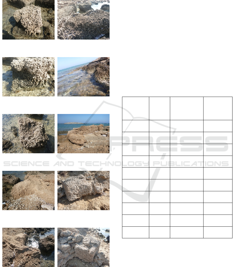
Images of Aeolianites that are situated in a quarry in
Naxos island, Greece are used for the demonstration
of the proposed methodology. The utilized images
can be found in Figure 1.
The initial images have resolution in pixels equal
to 3000 × 4000 pixels. Their spatial resolution gets
increased per the factor of 4 by means of the DRLN
super-resolution technique. The resulting SR images
have the resolution in pixels of 12000 × 16000.
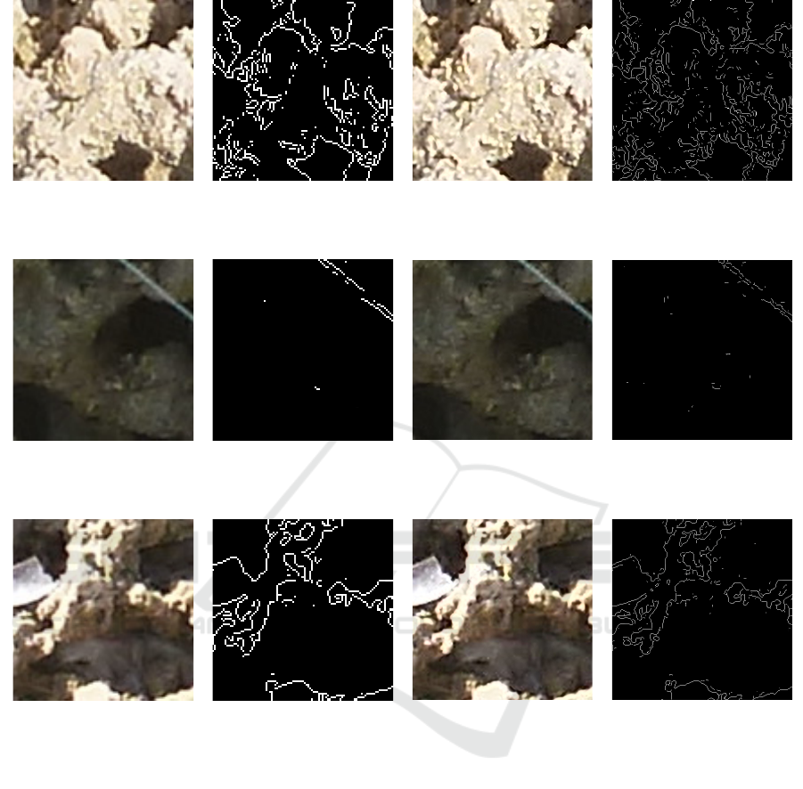
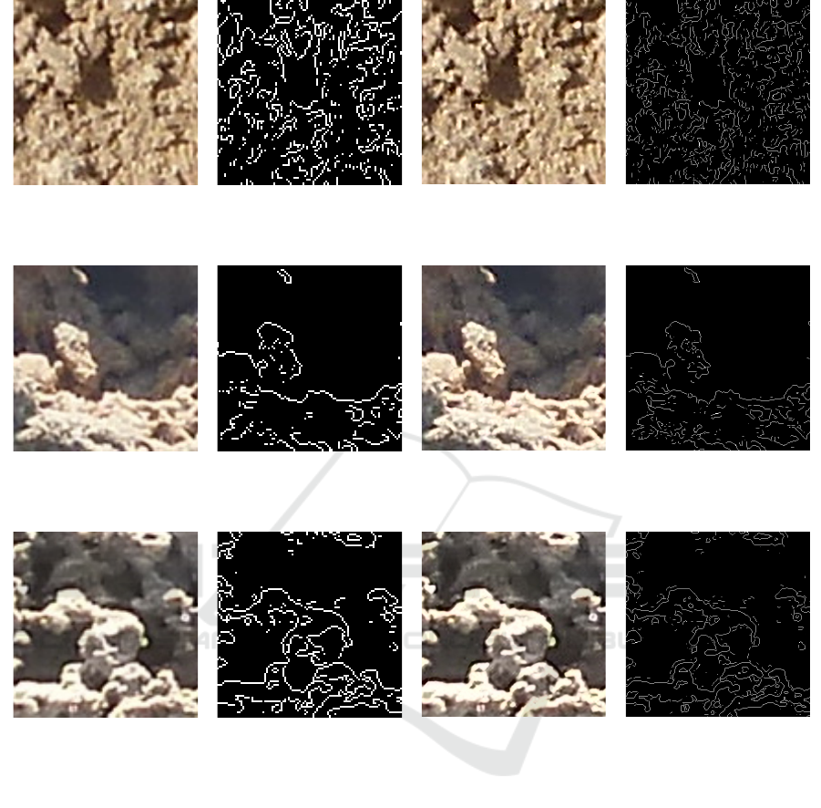
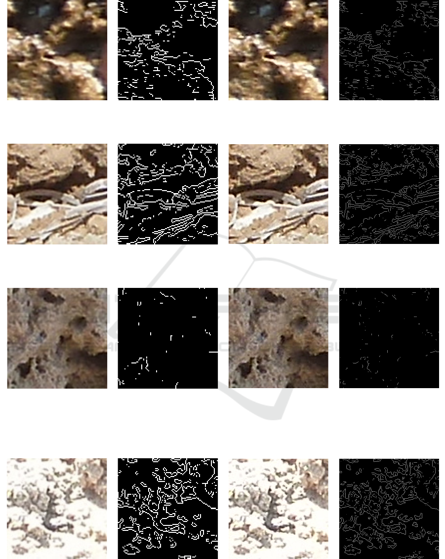
Selected Aeolianite parts from the initial images as
well as from the SR images are depicted in Figures
2-5. Sobel edge detection (Jiang and Scott, 2020) is
applied on the images for the delineation of any
inherent patterns. The corresponding selected edge
detected parts are also shown in Figures 2-5. The
Deep-Learning Based Super-Resolution of Aeolianite Images on the Purpose of Edge Detection and Pattern Extraction
245
number of connected components in the edge
detected Aeolianites can be found in Table 1.
P1050360 P1050396
P1050363 P1050404
P1050372 P1050411
P1050377 P1050422
P1050388 P1050426
Figure 1: The Aeolianite images under consideration, from
quarry in Naxos island, Greece.
The kernel size of the Sobel algorithm is equal to
3 × 3. Automatic count by means of Matlab has
given the number of connected components in Table
1. The enhanced image resolution allows to detect
patterns in the Aeolianites much more successfully
than the lower spatial resolution of the initial
images. Apart from visually, the proposed
methodology is also numerically validated. The
percentage differences of the connected components
or objects in the initial and in the DRLN super-
resolved images in Table 1 prove that super-
resolution contributes to the disclosure of patterns in
Aeolianites. In all 10 Aeolianite image scenes under
consideration, the SR enables the detection of
connected components per 63.30% to 83%.
Table 1: The number of connected components or objects
in the initial images and the corresponding super-resolved
images.
Image ID Initial DRLN Super-
Resolved
%
Difference
P1050360 126 642 80.37
P1050363 11 65 83.08
P1050372 43 240 82.08
P1050377 217 938 76.87
P1050388 75 228 67.10
P1050396 76 342 77.78
P1050404 126 463 80.40
P1050411 143 699 79.54
P1050422 40 109 63.30
P1050426 144 570 74.74
GISTAM 2023 - 9th International Conference on Geographical Information Systems Theory, Applications and Management
246
P1050360-initial
P1050360-initial-
edge detected
P1050360-DRLN
P1050360-DRLN-
edge detected
P1050363-initial
P1050363-initial-
edge detected
P1050363-DRLN
P1050363-DRLN-
edge detected
P1050372-initial
P1050372-initial-
ed
g
e detecte
d
P1050372-DRLN
P1050372-DRLN-
ed
g
e detecte
d
Figure 2: Selected small parts from the initial images and the super-resolved images of Aeolianite. The corresponding edge
detected images are also depicted.
Deep-Learning Based Super-Resolution of Aeolianite Images on the Purpose of Edge Detection and Pattern Extraction
247
P1050377-initial P1050377-initial-
edge detected
P1050377-DRLN P1050377-DRLN-
edge detected
P1050388-initial P1050388-initial-
edge detected
P1050388-DRLN P1050388-DRLN-
edge detected
P1050396-initial P1050396-initial-
ed
g
e detecte
d
P1050396-DRLN P1050396-DRLN-
ed
g
e detecte
d
Figure 3: Selected small parts from the initial images and the super-resolved images of Aeolianite. The corresponding edge
detected images are also depicted.
GISTAM 2023 - 9th International Conference on Geographical Information Systems Theory, Applications and Management
248
P1050404-initial
P1050404-initial-
edge detected
P1050404-DRLN
P1050404-DRLN-
edge detected
P1050411-initial
P1050411-initial-
edge detected
P1050411-DRLN
P1050411-DRLN-
edge detected
P1050422-initial
P1050422-initial-
ed
g
e detecte
d
P1050422-DRLN
P1050422-DRLN-
ed
g
e detecte
d
Figure 4: Selected small parts from the initial images and the super-resolved images of Aeolianite. The corresponding edge
detected images are also depicted.
P1050426-initial
P1050426-initial-
ed
g
e detecte
d
P1050426-DRLN
P1050426-DRLN-
ed
g
e detecte
d
Figure 5: Selected small parts from the initial images and the super-resolved images of Aeolianite. The corresponding edge
detected ima
g
es are also de
p
icted.
Deep-Learning Based Super-Resolution of Aeolianite Images on the Purpose of Edge Detection and Pattern Extraction
249

4 CONCLUSIONS
In this work the deep-learning based super-
resolution technique called DRLN is applied on
images of Aeolianites from a quarry in Naxos,
Greece. Edge detection for the delineation of
patterns on the images is performed on both the
initial images and the super-resolved images per
factor 4. The SR Aeolianite images reveal the
inherent patterns better than the initial images up to
the percentage of 83%. The methodology that is
presented in this work could serve as an excellent
tool for Aeolianite image preprocessing before a
classification or pattern extraction task.
REFERENCES
Anwar, S., Barnes, N. (2022). Densely Residual Laplacian
SuperResolution. In IEEE Transactions on Pattern
Analysis and Machine Intelligence, vol. 44, pp. 1192-
1204.
Bratsolis E. et al. (2018). Comparison of optimized
mathematical methods in the improvement of raster data
and map display resolution of Sentinel-2 images. In
2018 IEEE ICIP.
Chen, J., Yang, T., Zhang, D., Huang, H., Tian, Y. (2021).
Deep learning based classification of rock structure of
tunnel face. In Geoscience Frontiers, vol. 12, pp. 395-
404.
De Lima, R. P., Bonar, A., Coronado, D. D., Marfurt K.,
and Nicholson, C. (2019). Deep convolutional neural
networks as a geological image classification tool. In
The Sedimentary Record,pp. 4-9.
Dos Anjos, C. E. M. et al. (2021). Deep learning for
lithological classification of carbonate rock micro-CT
images. In Computational Geosciences, vol. 25, pp.
971-983.
Erginal, A. E. et al. (2022). Aeolian imprints of multiple
Mediterannean invasions of the Black Sea during
Pleistocene. In Palaeogeography, Palaeoclimatology,
Palaeoecology, vol. 592.
Fan, G., Chen, F., Chen, D., Li, Y. and Dong, Y. (2020). A
deep-learning model for quick and accurate rock
recognition with smartphones. In Hindawi Mobile
Information Systems, vol. 2020.
Goode, S. L. et al., (2021). Fine-scale mapping of mega-
epibenthic communities and their patch characteristics
on two New Zealand Seamounts. In Frontiers in Marine
Science, vol. 8.
Helm, C. W. et al. (2021). Large geometric patterns from
the middle stone age in Aeolianites on the Cape South
Coast, South Africa. In Rock Art Research, vol. 38, pp.
10-22.
Janowski, L. et al., (2021). Offshore benthic habitat
mapping based on object-based image analysis and
geomorphometric approach. A case study from the
Slupsk Bank, Southern Baltic Sea. In Science of the
Total Environment, vol. 801.
Janke, R. J. et al., (2015). Classification of debris-covered
glaciers and rock glaciers in the Andes of central Chile.
In Geomorphology, vol. 241, pp. 98-121.
Jiang, X. J. and Scott P. J. (2020). Characterization of free-
form structured surfaces, Chapter 11-Advanced
Metrology, pp. 281-317, Academic Press.
Juliani, C. and Juliani, E. (2021). Deep learning of terrain
morphology and pattern discovery via network-based
representational similarity analysis for deep-sea mineral
exploration. In Ore Geology Reviews, vol. 129
Liu, Y., Sun, W. and Durlofsky, L., J. (2019). A deep-
learning-based geological parameterization for history
matching complex models. In Mathematical
Geosciences, vol. 51, pp. 725-766.
Lou, Y. et al. (2022). Image-based machine learning for
monitoring the dynamics of the largest salt marsh in the
Yangtze River Delta. In Journal of Hydrology, vol. 608.
Niu, B. et al. (2020). Single Image Super-Resolution via a
Holistic Attention Network. In Vedaldi A., Bischof H.,
Brox T., Frahm JM. (eds) Computer Vision – ECCV
2020. ECCV 2020. Lect. Notes Comput. Sci., vol12357.
Springer, Cham.
Panagiotopoulou, A, Grammatikopoulos, L., Kalousi, G.
and Charou, E. (2021) “Sentinel-2 and SPOT-7 Images
in Machine Learning Frameworks for Super-
Resolution”. In Lect. Notes Comput. Sci., vol. 12667.
Springer, Cham.
Panagiotopoulou A. et al. (2022). Sentinel-2 images at 2.5m
spatial resolution via deep-learning: a case study in
Zakynthos. In Proceedings of 2022 IEEE IVMSP.
Piazza, G., Valsecchi, C. and Sottocornoloa, G. (2021).
Deep learning applied to SEM images for supporting
marine coralline algae classification. In Diversity, vol.
13.
Song, W., Dong, L.-H., Xia, X.-J. and Liu, T.-M. (2021).
Deep sea nodule mineral image segmentation algorithm
based on Mask R-CNN. In ACM TURC.
Stefouli, M. et al. (2019). Lignite mine monitoring and
mapping using freely-available radar and optical
satellite imagery. In International Journal of Mining
and Mineral Engineering, vol. 10, pp. 131-157.
Toulia, E., Kokinou, E. and Panagiotakis, C. (2018). The
contribution of pattern recognition techniques in
geomorphology and geology: the case study of Tinos
island (Cyclades, Aegean, Greece). In European
Journal of Remote Sensing, vol. 51, pp. 88-99.
Untiedt, C. B. et al. (2021). Identifying Black Corals and
Octocorals from Deep-Sea Imagery for Ecological
Assessments: Trade-offs between morphology and
taxonomy. In Frontiers in Marine Science, vol. 8.
Wenlong, Z., Yihao, L., Chao, D. and Yu. Q. (2021).
RankSRGAN: Generative adversarial networks with
ranker for image super-resolution. In Proceedings of
IEEE/CVF ICCV, pp. 3096-3105.
Zhang, Y., Wang, G., Li, M. and Han, S. (2018). Automated
classification analysis of geological structures based on
images data and deep-learning models. In Applied
Sciences, vol. 8.
GISTAM 2023 - 9th International Conference on Geographical Information Systems Theory, Applications and Management
250
