
Design of Geographic Entity Database of 3D Real Scene About
Xi’an City
Man Huang
1
, Zhouping Zhang
1
, Renyi Zhu
2
, Lin Yuan
1
, Chunkui Zhang
1
and Chuangqi Wu
1
1
Xi'an Institute of Surveying & Mapping, Xi'an City, People’s Republic of China
2
Shaanxi Surveying & Mapping Geographic Information Bureau, Xi'an City, People’s Republic of China
Keywords: New Fundamental Surveying & Mapping, 3D Real Scene, Geographical Entity Database, Knowledge Graph,
One Code Polymorphism.
Abstract: New fundamental surveying & mapping and the construction of 3D real scene construction have set off a
new wave in our country. As one of the pilot cities of new fundamental surveying & mapping, the Xi'an
pilot closely focuses on the six pilot tasks approved by the Ministry of Natural Resources to carry out real
construction of 3D real scene about Xi'an city. As an important part of the whole life cycle of geographic
entity data, the geographic entity data database stores and manages multi-source heterogeneous data from
the upstream production update system, builds the association relationship between geographic entity data,
and assembles derivative 3D standard products and application products as required, providing continuous
data blood for the "The Service Platform of 3D real scene about Xi'an city ". This paper mainly studies the
design of the Xi'an geographical entity database, including the overall design, logical design, management
system design, etc. It takes the geographical entity as the core and the geographical entity ID code as the
link to realize the multi-source heterogeneous geographical entity data polymorphism organization and
management.
1 INTRODUCTION
Global digital development is accelerating,
'space-time information, positioning and navigation'
service has become an important new infrastructure.
As a standard product of new fundamental surveying
& mapping, 3D real scene provides a unified spatial
positioning framework and analysis basis for digital
China. It is an important strategic data resource and
production factor for digital government and digital
economy. Recently, in China, the new fundamental
surveying & mapping and 3D real scene rise
gradually. Shanghai, Wuhan and other cities as a
pilot city have been approved. In order to actively
respond to the call and accelerate the pace of
achieving this goal, Xi'an city submitted an
application, and were approved as a new
fundamental surveying & mapping pilot city by the
Ministry of Natural Resources on November 9, 2020.
Around the six tasks, Xi'an pilot will establish a new
fundamental surveying & mapping database, and
build a real three-dimensional Xi’an city service
platform, also form a set of policy standards,
carrying out three demonstration applications and six
types of knowledge service. Finally, '1+1+1+3+6'
pilot results will be completed.
According to a series of standard documents issued
by the Ministry of Natural Resources, such as 'new
fundamental Surveying & Mapping Database
Construction Technical Guide', 'The Construction
Technical Outline about 3D Real Scene of China',
'The Database Construction Specification about 3D
Real Scene', With geographical entities as the unit,
the establishment of a 'multi-functional, on-demand
assembly' time-space database has become an
important pilot content.
2 DESIGN GOAL
Based on the Xi'an pilot implementation plan,
according to the new needs of urban natural resource
management and urban informatization development,
The geographic entity database about the 3D real
scene of Xi’an and its management system with the
characteristics of 3D, entities and semantics are
established. Also, this database has the following
characteristics, such as ground underground
58
Huang, M., Zhang, Z., Zhu, R., Yuan, L., Zhang, C. and Wu, C.
Design of Geographic Entity Database of 3D Real Scene About Xi’an City.
DOI: 10.5220/0012146000003562
In Proceedings of the 1st International Conference on Data Processing, Control and Simulation (ICDPCS 2023), pages 58-63
ISBN: 978-989-758-675-0
Copyright
c
2023 by SCITEPRESS – Science and Technology Publications, Lda. Under CC license (CC BY-NC-ND 4.0)

Figure 1: The ' Data Lake ' System of 3D real scene about Xi'an.
integration, indoor and outdoor integration,
two-dimensional and three-dimensional integration,
and spatial information and attribute information
integration.
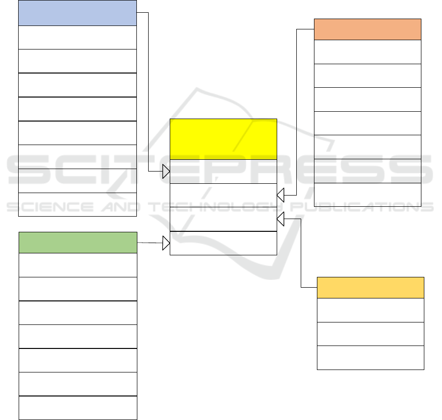
3 OVERALL DATABASE DESIGN
The database of 3D real scene about Xi'an using the
technology of data lake and data warehouse
integration (Fig.1), converge the time-space
information including full space, full elements, the
whole process. Also, this information is real,
three-dimensional and sequential. The management
system can build a knowledge graph among
geographical entities to help intelligent applications,
and also can achieve a database of multiple functions,
as needed to assemble a variety of standardized
products and the thematic products. It is deployed in
the internal network environment of Xi'an Surveying
& Mapping Institute, through the private cloud for
centralized storage, physical isolation with the
external network. Data is transmitted through the
service platform application library deployed by the
ferry machine to the external network.
The database mainly includes geographic entity
achievement database, 4E standardized product
database, IoT perception database and governance
database. The specific data types stored in each
database are as follows:
(1) The geographic entity achievement database
is used to store the full amount of data after quality
inspection, including four categories of geographic
entity data.
(2) The 4E standardized product database is used
to store the products derived from the achievement
sub-database according to the needs, including the
combined aggregation entity set, the stepless map
expression, the terrain level 3D real scene products
and the city level products.
(3) The IoT sensing data database is used to store
real-time sensing data of natural resources, urban
IoT sensing data and Internet online capture data,
which are associated with sensor entities to provide
dynamic geographic scenarios.
(4) The governance data database is used to store
the supporting data needed in the data governance
process, including metadata, data dictionary, index
data, entity management data, as well as system
management, security authentication, rights
management, and log records for the entire database
operation and maintenance support.
4 LOGICAL ARCHITECTURES
According to the classification of geographic entities
in Xi'an pilot, the achievement database of
geographic entity database can be divided into four
sub-databases: object entity sub-database,
geographic unit sub-database, geographic scene
sub-database and spatial grid sub-database. The data
Design of Geographic Entity Database of 3D Real Scene About Xi’an City
59
contained in each sub-database is as follows (Fig.2):
(1) The ground feature entities database includes
seven sub-databases: water system, residential area
and facilities, transportation, integrated pipeline,
landform, vegetation and soil, and place name and
address entities.
(2) The geographical units database includes
eight sub-databases: administrative division unit,
landform unit, natural and cultural protection zone,
fundamental geology unit, social comprehensive
management unit, land and sea unit, planning unit
and real estate unit.
(3) The geographic scene database includes
seven sub-databases: DOM, TDOM, DEM, DSM,
oblique photography 3D model, 3D laser point cloud,
panoramic image (street view).
(4) The spatial grid database includes three
sub-databases: The latitude and longitude, the plane
grid, and the three-dimensional grid.
The database of 3D real
scene about Xi 'an
+
The geographic entity
achievement database
+
The geographical units
database
+
The spatial grid database
The geographic entity
achievement database
+ The water system sub-database
+ The residential area and
facilities sub-database
+ The transportation sub-
database
+ The integrated pipeline sub-
database
+ The realm entity sub-database
+ The landform sub-database
+ The vegetation and soil sub-
database
The geographical units
database
+
The administrative division
unit sub-database
+
The landform unit sub-
database
+
The
natural protection
zone sub-database
The geographic scene database
+
The DOM sub-database
+
The
DEM
sub-database
+
The TDOM sub-database
+
The
DSM
sub-database
+
The 3D laser point cloud sub-
database
+
The oblique photography 3D
model sub-database
+ The social comprehensive
management unit sub-database
The spatial grid database
+
The latitude and longitude
sub-database
+
The Plane grid sub-
database
+
The
three-dimensional grid
sub-database
+
The geographic scene
database
+
The land and sea unit sub-
database
+
The planning unit and real
estate unit sub-database
+ The place name and address
entities sub-database
+
The fundamental geology
unit sub-database
+
The panoramic image sub-
database
Figure 2: Logical architecture of geographic entity database about Xi'an city
ICDPCS 2023 - The International Conference on Data Processing, Control and Simulation
60
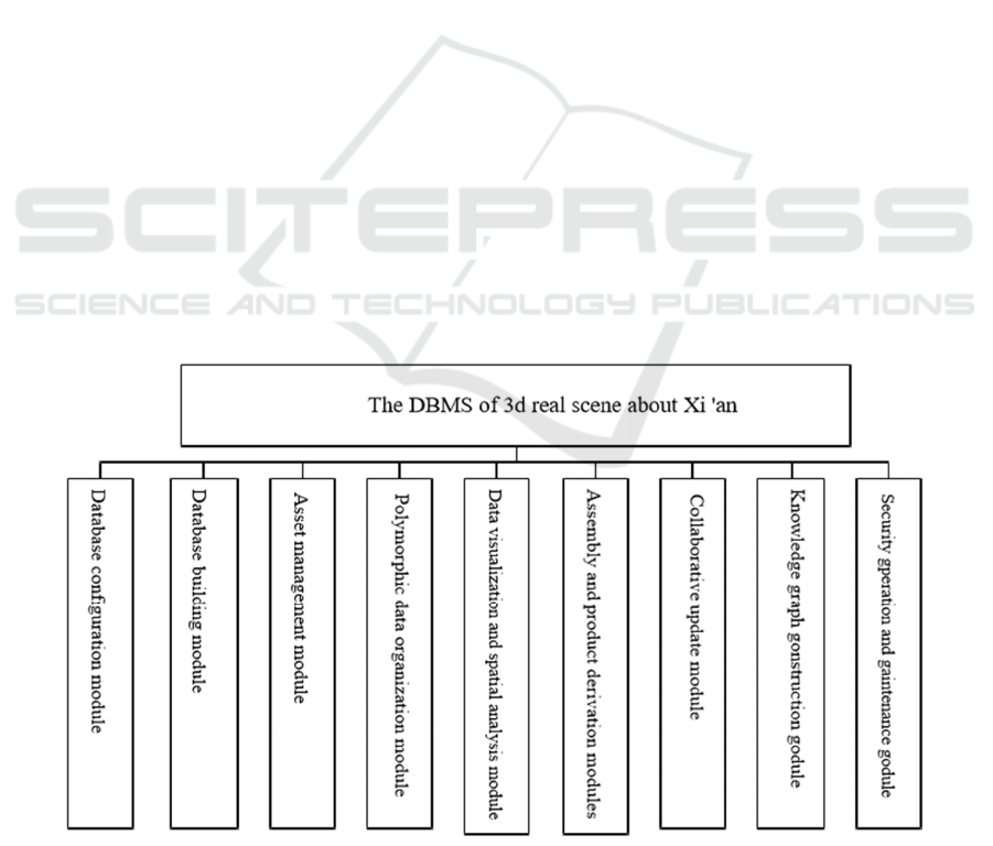
5 MANAGEMENT SYSTEM
FUNCTION DESIGN
The geographic entity database management system
(DBMS) of 3D real scene about Xi'an city is used to
establish, use, update, manage and maintain the
geographic entity database. Ensuring the security of
database and management system, the database is
controlled uniformly to effectively manage massive
heterogeneous data and keep the database data
current. At the same time, the history and version of
the data are reasonably organized to meet the
application requirements of high availability, high
throughput and random read and write of database
data. Through unique spatial identity coding, fast
coarse positioning, efficient retrieval and attribute
attachment of geographic entities are realized. Using
two-three-in-one visual graphical interface to
achieve geographic entity data browsing and query,
multi-user concurrent access control and recovery
database. The main function modules of the database
management system are shown in the Fig.3.
(1) Database configuration module
The connection information of the database can
be created and configured, and the connection
information can be managed. Also, metadata
templates can be created, edited and managed. Users
can create metadata templates according to business
requirements and establish the relationship between
metadata and entity data. At the same time, data
dictionaries can be created, edited and managed,
including entity classification dictionaries, entity
relationship dictionaries, etc. The functions of the
common spatial geographic data format conversion
and the coordinate conversion are developed to
ensure that data can be in and out of the database.
(2) Database building module
Entity data is checked before storage, including
organizational structure standardization inspection,
naming specification inspection, attribute value
filling specification inspection, primitive topology
relationship inspection, etc., to ensure data integrity,
logical consistency, spatial accuracy and attribute
accuracy.
While the entity data is stored in the database, the
geographic entity object is given a unique identity
code calculated according to the geographical
location. The geographic entities are linked to related
two-dimensional data, three-dimensional data, IOT
sensing data, industry management and other
multi-source data through this code.
(3) Asset management module
All data assets through the asset directory are
visually displayed, and the target data of concern can
be quickly located. The status quo and use of all data
assets can be classified and counted, and then the
changes in asset information and asset statistics
details can be found out. After statistical summary,
the final report can be generated.
Figure 3: The functional module of DBMS about Xi'an city.
Design of Geographic Entity Database of 3D Real Scene About Xi’an City
61

(4) Polymorphic data organization module
Geographical entities can realize the expression
of different historical time and different spatial forms
with the unique identifier as the link. The stored
geographic entity vector, image, 3D model data and
other spatial form data are associated and organized
by unique identification code, forming the
comprehensive structural data that can find all data
forms. The data generated in the whole life cycle of
geographical entities from generation to loss is
temporally managed.
(5) Data visualization and spatial analysis
module
The target resource directory can be quickly
located based on the search, and the target
geographic entity is highlighted in the view area.
Then click on it, in two-dimensional visualization
interface display. At the same time, the scene data,
such as DOM, TDOM, DEM, DSM and so on, can
be queried and browsed, and can also be retrieved
according to the specified spatial range. Geographic
entity attribute information and knowledge graph
information can be queried in the visual view area.
Common spatial analysis functions such as spatial
measurement, overlay analysis, and spatial statistical
analysis can be performed.
(6) On-demand assembly and product derivation
modules
The package assembly can be realized according
to the themes of natural resources, transportation,
water conservancy, civil affairs and other industries,
as well as the themes of education, medical care and
health. Also, the custom assembly can be realized by
filtering according to the scope of interest, the
address of interest place name or even semantic
conditions. At the same time, terrain-level, city-level
and component-level 3D products can be derived.
Traditional topographic map products and national
and provincial fundamental geographic entity
products also can be derived through stepless
mapping technology to achieve the goal that a
geographic entity is only measured once.
(7) Collaborative update module
Through image change discovery and internet
change discovery technology, the geographic entity
targets to be updated is acquired, and the update
collection is completed by means of the
crowdsourcing software system. Before updating the
entity, it is necessary to determine whether it is
spatial information update or semantic information
update. For the newly added geographic entity, the
geographic entity needs to be initially encoded and
then stored; For the updated and modified
geographic entities, it is necessary to find the
original geographic entity in the database, record its
demise time, and then encode the updated
geographic entity to ensure that it is not repeated
with the data encoding in the entity library, and then
store the updated geographic entity.
(8) Knowledge graph construction module
Using the ID card code as the unique identifier of
the geographic entity, the data association is
established through batch construction or
human-computer interaction based on spatial
relationships, generic relationships, and temporal
relationships. Then, the geographic entity big data
relationship graph is constructed and stored in the
database. Search Interest Knowledge graph of
geographic entities, you can flexibly click on the
geographic entities on the map, linkage in the view
highlights and query the relevant attribute
information.
(9) Security operation and maintenance module
Users can be added, enabled, disabled, deleted by
the system administrator, and different user types
and functional permissions can be set. At the same
time, it can set and manage the scope, content and
usage time of users ' browsing and editing data. It
supports task flow operation log and operation and
maintenance monitoring log, and supports log query
and export, which can be used as the basis and
evidence for system security review. Full backup and
incremental backup of database system can be
carried out to deal with data loss caused by various
accidents. Also, the monitoring, management and
self-repairing of all software and hardware
information in the distributed cluster system can be
realized through the unified interface.
6 CONCLUSION
The geographic entity database of 3D real scene
about Xi'an city is an important part of the national
new fundamental surveying & mapping Xi'an pilot
construction. Closely around the building
requirements of the Ministry of Natural Resources,
the scientific management of geographic entity data,
efficient update, knowledge map construction, etc.
have been explored, and ultimately achieve ' one
library multi-functional, on-demand assembly ' goal.
This Study will help the transformation and
upgrading of fundamental surveying & mapping in
ICDPCS 2023 - The International Conference on Data Processing, Control and Simulation
62

Xi'an, and provide reference, replicable and
replicable experience for other new fundamental
surveying & mapping pilots.
REFERENCES
Letter No.924 from the Ministry of Natural Resources of
the People 's Republic of China on approving Xi’an
as a pilot city for new fundamental surveying &
mapping construction.
Natural Resources Office Letter No.1578, Technical Guide
for Pilot Construction of New Fundamental
Surveying & Mapping System Database [S].
Construction Technology Outline of 3D Real Scene about
China [S].
The Database building Specification of 3D Real Scene [S].
Xi'an pilot Implementation Plan of national new
fundamental surveying & mapping construction [R].
Xi’an: Xi’an Institute of Surveying & Mapping, 2020.
Preliminary design scheme of Xi’an pilot project of
national new fundamental surveying & mapping
construction (feasibility study report) [R]. Xi’an:
Xi’an Surveying & Mapping Institute, 2021.
National new fundamental surveying & mapping
construction Xi’an pilot fundamental geographic
entity classification code [S].
National new fundamental surveying & mapping
construction Xi’an pilot fundamental geographic
entity data specification [S].
GB-T18578-2016, urban geographic information system
design specification [S].
Design of Geographic Entity Database of 3D Real Scene About Xi’an City
63
