
SMaNa: Semantic Mapping and Navigation Architecture for
Autonomous Robots
Quentin Serdel
a
, Julien Marzat
b
and Julien Moras
c
DTIS, ONERA, Universit
´
e Paris-Saclay, 91123 Palaiseau, France
Keywords:
Field Robots, Mapping, Navigation, Semantics.
Abstract:
Motivated by recent advances in machine learning applied to semantic segmentation, online 3D mapping
is being extended to integrate semantic data. As these developments pave the way to the improvement of
many robotic functionalities, the application of semantic mapping for navigation tasks remains to be further
explored. In this paper we present an online Semantic Mapping and Navigation ROS architecture (SMaNa),
with autonomous exploration as an application example. It is intended to be generic, so as to exploit state-
of-the-art semantic mapping methods for unstructured environment and adapt them to perform jointly with a
navigation graph builder and a semantic-aware A* path planner. The adequacy of multiple semantic mapping
solutions for robot navigation in open environment and the performances of the architecture given the influence
of localisation and semantic labelling uncertainty are evaluated in a closed-loop Ignition Gazebo simulation
built from the 3DRMS synthetic dataset, and on the outdoor RELLIS-3D dataset.
1 INTRODUCTION
Exploration robots in hazardous environments (e.g.
Martian ground or post-catastrophe urban area) re-
quire a high level of understanding of their sur-
roundings in order to evolve efficiently and safely
in an uncharted, potentially unstructured territory.
Most existing functional architectures such as Au-
Spot (Bouman et al., 2020) rely on geometric and pro-
prioceptive data when performing navigation tasks.
The incorporation of semantics into the mapping
and navigation process of robots would allow them
to reach unprecedented adequacy and autonomy for
these tasks. Latest progress in machine learning ap-
plied to online semantic segmentation of images and
point clouds (He et al., 2020; Lambert et al., 2020;
Qi et al., 2017) allowed for the development of se-
mantic mapping methods such as (Grinvald et al.,
2019; Grinvald et al., 2021; Xuan and David, 2018;
Rosinol et al., 2020) but their application to au-
tonomous robot navigation remains to be pursued.
Moving forward into real-world applications of se-
mantic robotic exploration, semantic-aware naviga-
tion must be tackled jointly with semantic mapping.
a
https://orcid.org/0009-0006-7612-2663
b
https://orcid.org/0000-0002-5041-272X
c
https://orcid.org/0000-0003-2959-7544
This paper presents a Semantic Mapping and Navi-
gation architecture (SMaNa) for ground exploration
robots in unstructured environment, with a focus on
the link between these two functionalities and the as-
sociated combined performances in particular under
localisation and classification uncertainty. SMaNa
has been built to be able to integrate semantic map-
ping solutions in a generic way. We present the ap-
plication of two online 3D mapping methods: Oc-
tomap and TSDF, previously adapted to include se-
mantics respectively in (Xuan and David, 2018) and
(Rosinol et al., 2020). A semantic navigation graph
builder which can adapt to the output of each mapping
process and a weighted A* path planner allowing on-
line exploitation of the scene semantics for navigation
tasks are then introduced.
1
The evaluation of the proposed combined seman-
tic mapping and navigation system has been per-
formed in closed-loop simulation, using a Ignition
Gazebo simulated environment generated from the
3DRMS synthetic dataset (Tylecek et al., 2019), as
well as on real-world outdoor trajectories in the
RELLIS-3D dataset (Jiang et al., 2021). The pro-
posed architecture was used to compare the two afore-
mentioned state-of-the-art mapping solutions in order
1
A video presentation of SMaNA is available at
https://tinyurl.com/SMaNaONERA
Serdel, Q., Marzat, J. and Moras, J.
SMaNa: Semantic Mapping and Navigation Architecture for Autonomous Robots.
DOI: 10.5220/0012192800003543
In Proceedings of the 20th International Conference on Informatics in Control, Automation and Robotics (ICINCO 2023) - Volume 1, pages 453-464
ISBN: 978-989-758-670-5; ISSN: 2184-2809
Copyright © 2023 by SCITEPRESS – Science and Technology Publications, Lda. Under CC license (CC BY-NC-ND 4.0)
453

to select the most suitable one for the purposes of
semantically-aware robotic navigation in the presence
of noisy data and uncertain estimates and to evaluate
their respective computational cost. As an applica-
tion example, this architecture has also been extended
to carry out an autonomous exploration task, and the
benefits of using such a semantic-aware mapping and
navigation system have been quantified in the case of
terrains with different traversability constraints.
2 RELATED WORK
The breakthrough of machine learning applied to
semantic segmentation allowed to enrich the previ-
ously geometric-only robotic mapping process with
the integration of semantic information. The prob-
lem of efficient semantic data integration to incre-
mentally build maps has been tackled by many au-
thors (Grinvald et al., 2019; Grinvald et al., 2021;
McCormac et al., 2017; Rosinol et al., 2020; Mar-
tins et al., 2020; Ewen et al., 2022). It has already
been demonstrated that the incorporation of semantic
data to robotic mapping provides significant improve-
ment for the application of SLAM (Xuan and David,
2018; Cheng et al., 2022). A first survey of seman-
tic map representations for robot navigation has been
presented in (Crespo et al., 2020). Most of the pre-
sented method categories use high-level or topologi-
cal semantic representations, resulting in a significant
improvement for robot task performance, human re-
quest satisfaction and navigation in indoor applica-
tions (Hughes et al., 2022; Sun et al., 2019; Wang
et al., 2021). However these approaches hardly ap-
ply to outdoor unstructured environments, since the
labels should be used at a lower level within a dense
semantic representation rather than focusing on par-
ticular instances. Most of the developed dense se-
mantic mapping methods have focused on the effi-
cient and precise integration into the dense map, us-
ing probabilistic fusion (Rosinol et al., 2020; Xuan
and David, 2018) and association between depth and
semantic segmentation (Grinvald et al., 2019; Grin-
vald et al., 2021) for labelling. These methods are
claimed to be fitted for robot navigation and explo-
ration however, to the best of our knowledge, the in-
tegration of these semantic mapping approaches in a
robot planning and navigation pipeline has been lit-
tle studied so far. Semantic-aware navigation meth-
ods in unstructured environment have been proposed
lately in (Maturana, 2022; Seymour et al., 2021; Bar-
tolomei et al., 2020). (Achat et al., 2022) presented
the development of a robot semantic-aware path plan-
ning method relying on a ground truth semantic 3D
grid, so as to perform next-best-view exploration and
observation as well as terrain classification for safe
navigation. However, few studies have tackled the
extension of the navigation process to implement a
practical and efficient interaction with semantic map-
ping. A semantic mapping and navigation method
focused on terrain traversability for the safe travel-
ling of a rover on Martian ground has been proposed
in (Ono et al., 2015), but this work remains specif-
ically designed for the rover locomotion and part of
the process if performed offline due to high computa-
tional needs. The update of uncertain semantic maps
using noisy observations has been studied in (Kan-
taros et al., 2022) with a focus on collaborative tasks.
In (Maturana, 2022), a joint dense semantic mapping
which relies on prior available knowledge associated
to a view-point selection method has been presented
to carry out the task of car inspection in outdoor envi-
ronment by a Micro-Aerial Vehicle. In this paper, we
extend and evaluate the joint conception of semantic
mapping and navigation methods to a wider outdoor
unstructured context with a practical focus on online
capacities and quantification of robustness to locali-
sation and labelling uncertainty.
3 SMaNa ARCHITECTURE
DESCRIPTION
The ROS-based SMaNa architecture (illustrated in
Figure 1) is composed of three main building blocks:
a 3D semantic mapping process (either Semantic-
Octomap or Kimera-TSDF in this work), a 2.5D nav-
igation graph builder and a semantic-aware A* path
planner.
3.1 Input Data
The SMaNa architecture requires the robot localisa-
tion to be provided, typically given by a SLAM al-
gorithm, along with a labelled point cloud. The lat-
ter can be produced using a stereo or RGB-D cam-
era, or with a LiDAR coupled with a RGB camera.
The point cloud labelling can be achieved through
the application of a semantic segmentation Convolu-
tional Neural Network (CNN) on the camera images
as in (He et al., 2020; Lambert et al., 2020; Takikawa
et al., 2019), which is then geometrically projected
onto the point cloud. Other types of Neural Networks
such as PointNet (Qi et al., 2017) directly work on
point clouds to produce semantic segmentation. The
application targeted is mainly the safe navigation in
unstructured and uncharted environments, therefore
segmentation networks specialised in terrain classi-
ICINCO 2023 - 20th International Conference on Informatics in Control, Automation and Robotics
454

Labelled
Point Cloud
3D Dense
Mapping
Robot
Localisation
Volumic (Octomap)
or Surfacic (TSDF)
Goal Points
Semantic A*
Path-finder
2.5D Navigation
Graph building
Robot Path
2.5D Navigation
Graph
Data
Process
3D
Map
Figure 1: Overview of the SMaNa architecture.
fication (Z
¨
urn et al., 2020; Ewen et al., 2022) could
be exploited to produce the required input. Dynamic
objects in the robot environment (e.g. pedestrians or
moving cars) should be identified using methods such
as (Chen et al., 2021) and are assumed to be treated
separately from the static scene point cloud before the
latter is integrated into the 3D map.
3.2 Semantic Mapping
The architecture can integrate any 3D semantic map-
ping method compatible with the defined inputs. Two
widely used methods, considered as references in the
robot mapping domain with available implementa-
tions incorporating semantics have been selected for
integration in SMaNA and for comparative evalua-
tion. This section briefly describes those methods and
their implementations.
3.2.1 Semantic Octomap
Semantic Octomap (Xuan and David, 2018) is an on-
line ROS localisation and 3D semantic mapping ar-
chitecture. In our context, only the mapping stack is
used. The mapping is performed thanks to the use
of the well-known Octomap package (Hornung et al.,
2013), which provides an octree-based voxel volu-
mic mapping representation. The hierarchical octree
structure allows fast queries in O(log n) with n being
the number of octree nodes, and low memory con-
sumption, making it adequate to online embedded ap-
plications such as robot exploration. Each point from
the input cloud is associated to a leaf voxel based
on its corresponding position. In classical Octomap,
probabilistic sensor fusion is used to update the oc-
cupancy of voxels from multiple observations. In its
semantic extension, additional information related to
labels and their confidence is stored and fused. Se-
mantic Octomap implements two different strategies
for handling labels, namely max and Bayesian. The
max method has been applied in this paper as it re-
quires less complex data transport. It stores a label
and an associated confidence for each voxel. The la-
bel of a voxel is updated if a point of different label
and higher confidence falls into the voxel. Voxel con-
fidence is increased for each point of same label and
decreased for each point of a different label with a
lower confidence. On the other hand, the Bayesian
strategy uses the full semantic likelihood input and
performs the merge using the Bayesian fusion rule.
Since this approach would require to store for each
voxel the probability of each class, an approxima-
tion is used in Semantic Octomap where only the 3
most likely classes are stored and the other classes
are assumed to be evenly distributed. For each seman-
tic cloud processed, the Semantic Octomap algorithm
has been adapted to produce a sparse point cloud con-
taining the positions and labels of all updated voxels,
which is sent to the navigation stack.
3.2.2 Kimera Semantics
Kimera Semantics (Rosinol et al., 2020) also per-
forms online localisation and 3D semantic mapping in
a ROS environment, relying on Voxblox (Oleynikova
et al., 2017) for mapping. Voxblox is a TSDF sur-
facic (Nießner et al., 2013) mapping package rely-
ing on voxel hashing and marching cubes. When a
semantic point cloud is produced, ray casting is per-
formed between the sensor position and each point
of the cloud. The distance to the point is computed
and allocated to voxels along the ray up to a threshold
fixed to 2 times the voxel resolution before and after
the point. The point label is allocated to those vox-
els. Voxels are then gathered in blocks that are hashed
and stored with their position in the TSDF map on
which queries can be made in O(1). A surface mesh is
computed using marching cubes on the TSDF voxels.
SMaNa: Semantic Mapping and Navigation Architecture for Autonomous Robots
455

The fast TSDF mapping method, found to be faster
without significant precision loss in preliminary tests
is used here due to real-time constraints. It discards
all rays from a point cloud which attempt to update
a voxel that has already been updated by a ray from
the same cloud. In the extended semantic implemen-
tation, each TSDF voxel stores a vector of label prob-
abilities, updated according to the number of points
with associated labels integrated to the voxel follow-
ing a Bayesian approach. At a given instant, the label
of highest probability is selected as the output voxel
label. For each point cloud processed, the TSDF map
is produced and sent to the navigation stack.
3.3 Semantic Navigation
The SMaNa navigation stack consists of an on-
line 2.5D semantic navigation graph builder and a
weighted A* path-finder. The graph builder collects
data from the mapping stack and integrates it into an
exploitable structure for navigation. The weighted A*
algorithm performs optimal path-finding inside the
2.5D navigation graph layer.
3.3.1 Navigation Graph
A 2.5D graph layer is built online, integrating new el-
ements from the 3D map to create and update nodes.
It is set to receive 3D mapping data, either from Oc-
tomap as a point cloud or Kimera as a TSDF map.
Each point (representing an updated voxel) of the Oc-
tomap cloud message is associated to a node position
in the navigation grid. The received TSDF map from
Kimera is deserialised and each voxel whose absolute
distance to its surface is smaller than the node resolu-
tion is associated to a node position in the grid.
After this projection step which is specific to each
type of mapping input, the remaining treatment is
generic. A fixed maximum size of the graph is given
as starting parameter. To ensure efficient memory
consumption, nodes inside the graph boundaries are
allocated only when data from the 3D map at the same
position becomes available. Graph nodes contain a
class label, a height and their absolute coordinates as
well as pointers to other nodes for the use of a plan-
ning algorithm. Each received voxel is associated to
the graph node of corresponding (x,y) coordinates. If
the node is uninitialised, the label l and height z of
the first associated voxel are allocated to it. Else, the
node’s l and z values are replaced by the label and
height of the associated voxel of highest altitude (a
specific threshold could be used instead for particu-
lar needs). Some non-traversable labels (e.g., those
displayed in dark gray in Table 1) are considered as
obstacles, as a consequence the nodes associated to
Semantic Octomap Pipeline
Kimera Semantics Pipeline
Deserialize
and Project
Kimera
(TSDF)
Semantic
Octomap
Updated Voxels
TSDF map
Project on
Grid
Update
Nodes
Extrude
Obstacles
{i,j,h,label}
Graph
Nodes
Safety zone
On planner
call
Figure 2: SMaNa navigation graph building. Either Kimera
or Semantic Octomap can be used for mapping in the cur-
rent implementation.
these labels are marked as unselectable for the plan-
ning algorithm. Each node then contains a safety zone
Boolean variable which is set to true for nodes located
around obstacle nodes as far as a given robot radius
parameter, marking them as non-traversable for the
planning algorithm. Obstacle nodes are stored in a
dynamic vector and the calculation of the safety zone
is performed for each of them when the path planner
is called to use the most recent fused label integra-
tion. Figure 2 illustrates the building and update of
the graph from either one of the mapping methods.
This process has been designed to be extensible to
other mapping methods, as long as their output can
be handled similarly.
3.3.2 Weighted A* Path planning
The path finding inside the 2.5D navigation graph is
solved using a weighted A* algorithm, inspired by
the work presented in (Achat et al., 2022). All nav-
igable classes of the environment are associated to
a traversability coefficient, which is used to penalise
nodes in the A* algorithm. This process allows the
robot to choose and follow a safer and more efficient
path regarding the nature of its surrounding terrain.
The height difference between two neighboring nodes
is also included in the A* cost calculation to prevent
the robot from crossing too steep slopes. The set of al-
ready evaluated nodes is kept in memory as the union
of the closed set C and the free set F which contains
the non-obstacle nodes neighboring the closed set. It
is initialised with a closed set containing the start-
ing node and a free set containing its neighbors. At
each iteration, the A* algorithm calculates or updates
the weights of the nodes newly added to the free set.
The weight of the nodes is not pre-calculated when
the navigation graph is built, preventing unnecessary
calculation for nodes that might never be visited. The
graph holds an 8-connectedness between neighboring
nodes. The transition cost for each node n from its
parent p is calculated as:
c(p → n) = d(p,n) + h
f
.|h(n) −h(p)| +t
f
.T (l) (1)
with d(n,m) the distance between two nodes, h(n) the
node’s height, T (l) the cost associated to the node la-
bel l. The weights h
f
and t
f
should be chosen by the
ICINCO 2023 - 20th International Conference on Informatics in Control, Automation and Robotics
456
Unvisited
Node
label, height
Node neighbor
is visited
Open Node
label, height,
total cost
parent
neighbor
Node is visited
Closed
Node
label, height, total
cost
child
neighbor
parent
neighbor
If neighbor
node is
traversible
x8
Figure 3: Navigation graph node visit when performing
weighted A*.
user, in this work they were respectively fixed to 0.1
and 0.8. The total cost T
c
(n) of the node for the A* al-
gorithm to select the next best candidate is calculated
as follows:
T
c
(n) = T
c
(p) + c(p → n) +d(n,g) (2)
with g the goal node of the A* path finder. Algorithm
1 details the process of this weighted A* path-finding,
with N (n) being the set of neighbors of node n and
p(n) being the parent of node n. Figure 3 illus-
trates the processing of a single node during A* path-
finding.
Data: 2.5D navigation grid with nodes:
n{l,h,p,N (n)}, Start node s, Goal node g,
Set of closed nodes C{s}, Set of free
nodes F{N (s)}, A* path P
while g /∈ C or F ̸=
/
0 do
C ← n ∈ F | T
c
(n) = min(T
c
(F)) ;
for each node nb neighboring n do
if nb is traversable then
N (n) ← nb ;
calculate transition cost c(n → nb)
(1);
calculate total A* cost T
c
(nb) (2);
p(nb) = n ;
F ← nb ;
end
end
end
if g ∈ C then
n = g;
while p(n) ̸= s do
P ← n;
n = p(n);
end
P ← s;
return P
end
Algorithm 1: SMaNa weighted A* algorithm.
4 EXPERIMENTS IN
SIMULATION
SMaNa has been applied and evaluated in terms of
mapping precision under various levels of noise on in-
put localisation and semantic segmentation. The Oc-
tomap and TSDF methods precision were both evalu-
ated in a new Ignition Gazebo simulated environment
built from the 3DRMS dataset ground truth point
cloud (Tylecek et al., 2019) shown in Figure 4. An
application to autonomous exploration has been per-
formed within the same environment in order to high-
light the interest and applicability of this semantic-
aware mapping and navigation system. In order to
assess the performances of this architecture in an on-
line embedded context, its RAM and CPU consump-
tions and the average integration time of a point cloud
to the map and graph have been evaluated using the
RELLIS-3D outdoor dataset (Jiang et al., 2021). The
evaluation was performed on a Intel Xeon(R) W-
2123 8 core 3.60GHz CPU with 16 GB of RAM,
with no GPU required. Qualitative results of navi-
gation graphs as well as examples of semantic-aware
weighted A* paths are also provided.
4.1 Simulation Description
Our main objective here is to evaluate the perfor-
mance of the SMaNa architecture on the semantic
mapping capability but also on its ability for mobile
robot navigation in a representative unstructured en-
vironment. This requires what we call a closed-loop
simulation environment where a semantic sensor view
can be generated from the current robot pose, and
a ground truth semantic 3D model (mesh or point
cloud) can be available to compute relevant metrics.
On the one hand, there are many semantic datasets
available for different purposes, e.g. RELLIS-
3D (Jiang et al., 2021) or the 3DRMS challenge (Tyle-
cek et al., 2019) in off-road environments, Se-
manticKitti (Behley et al., 2019) for urban navigation,
SceneNN (Hua et al., 2016) in an indoor office en-
vironment. However, there is usually no 3D ground
truth provided with these datasets, which strongly
limits their usage for our purpose. An exception is
the 3DRMS-challenge synthetic dataset which con-
tains a ground truth semantic point cloud, it has
moreover been exploited to evaluate semantic-aware
navigation in (Achat et al., 2022). On the other
hand, there are also few simulation environments
with built-in semantic-world representations for the
targeted autonomous mobile robot application with
traversability considerations and mapping evaluation.
The TESSE simulator (Ravichandran et al., 2020) is
probably the closest related work including a com-
bination of metric-semantic data and physics-based
simulation, however only an indoor office environ-
ment with object-oriented tasks has been made avail-
able in the ICRA 2020 GOSEEK challenge
2
without
2
https://github.com/MIT-TESSE/goseek-challenge
SMaNa: Semantic Mapping and Navigation Architecture for Autonomous Robots
457

direct access to the 3D ground truth. The CARLA
simulator (Dosovitskiy et al., 2017) is dedicated to
the evaluation of autonomous driving systems in ur-
ban environments and can generate semantized sen-
sor views but no 3D ground truth. The Micro-Air
vehicle Flightmare simulator (Song et al., 2021) is
also able to simulate RGB cameras with ground truth
depth and semantic segmentation, however the 3D
ground truth model only provides occupancy and not
semantics. Moreover, neither of these simulators are
natively dedicated to field robotic navigation, and so
they are not easily applicable to consider traversabil-
ity constraints.
We therefore propose a new simulation setup with
all the required features, which will be contributed to
the community. It is based on the openly available Ig-
nition Gazebo engine
3
, which offers the possibility to
render RGB, depth and semantic images, natively in-
tegrates a physics engine, and can interact easily with
the ROS-based infrastructure. Following the above
dataset and simulator review, we selected the 3DRMS
dataset to build the test environment. This dataset
was initially proposed to evaluate semantic 3D recon-
struction in the context of robot navigation in an out-
door environment of around 12 m × 12 m. The se-
mantic is described using 8 classes, given in Table 1.
The ground truth semantic point cloud was used to
reconstruct meshes to populate the world (and it is
thus also available to evaluate the mapping). Points
of each class were split to build one mesh per class
and then added to a SDF world file with a specific
label. Ground and objects have been processed us-
ing two different pipelines. The objects have been
reconstructed using voxelization with a resolution of
5 cm whereas the ground has been reconstructed us-
ing the Poisson reconstruction algorithm (Kazhdan
et al., 2006) to obtain a smooth surface compatible
with robot wheel motion. To perform this reconstruc-
tion, a pre-filtering was applied on the point cloud to
remove superimposed ground layers. Finally, bound-
ary walls were added to maintain the robot into the
world. The robot model considered is the Wifibot
wheeled differential-drive robot equipped with a front
sensor providing RGB, depth and semantic segmenta-
tion in undistorded, rectified images with a resolution
of 640x640 at a rate of 30 Hz with a field-of-view
of 57°. The simulator also provides the ground truth
pose of the robot base link.
3
https://gazebosim.org
Table 1: Colors and traversability costs associated to
semantic classes simulated in Ignition Gazebo from the
3DRMS dataset.
class
unknown
grass
terrain
hedge
topiary
rose
obstacle
tree
color
cost 2 1
4.2 Mapping Robustness to Noisy
Inputs
4.2.1 Production of Degraded Data
Semantic information produced by segmentation neu-
ral networks are not perfect and generate some clas-
sification errors. This must be considered when eval-
uating mapping algorithms to be realistic. However,
using NN-based algorithms in simulation is challeng-
ing and presents a high risk of giving unrealistic re-
sults. Different segmentation approaches may also
behave very differently so the result could be depen-
dent on one particular algorithm. This is why we pro-
posed instead to simulate the semantic segmentation
errors to overcome these biases.
The ground truth robot localisation and seman-
tic segmentation of the robot camera images have
been artificially degraded in order to evaluate the ro-
bustness of the mapping algorithms to noisy inputs.
Gaussian noises of parameterised variance have been
added to the ground truth robot position and yaw an-
gle. To degrade the ground truth semantic segmen-
tation images, a superpixel segmentation using the
SLIC method (Achanta et al., 2012) has first been
applied to each of them. Each superpixel is associ-
ated to the most frequent semantic label of the pix-
els within its borders. To simulate the misclassifica-
tion that can be typically produced by a semantic seg-
mentation network, the label of each superpixel has
a probability of being changed according to a confu-
sion matrix (similar in spirit to (Krstini
´
c et al., 2020))
defined in Table 2. Four different levels of misclas-
sification probabilities, chosen to be comparable to
the RELLIS-3D semantic segmentation benchmark
results, have been set for evaluation. A random clas-
sification confidence between 0.33 and 1.0 was asso-
ciated to each pixel (see Figure 5).
4.2.2 Mapping Precision Evaluation
The precision of both Semantic Octomap and fast Se-
mantic TSDF mapping methods from noisy inputs has
been evaluated with the robot following an arbitrary
44 m long trajectory in the simulated environment.
The mapping resolution for both methods has been
ICINCO 2023 - 20th International Conference on Informatics in Control, Automation and Robotics
458

Figure 4: Ignition Gazebo simulation environment based on a ground truth point cloud from the 3DRMS dataset and a ground
robot model. The robot is equipped with a differential drive module taking a velocity command as input and outputting the
robot pose along with a simulated camera producing RGB images, depth maps and semantic segmentation images.
Figure 5: Example of the degradation of a ground truth semantic image taken from the simulation using the proposed SLIC
superpixel confusion method.
Table 2: Confusion matrix for superpixels misclassification
probabilities, the values of p for the 4 level of noise (none,
low, medium, high) are respectively 1.0, 0.9, 0.8 and 0.7.
0 1 2 4 5 6 7 8
0 1 0 0 0 0 0 0 0
1 0 p (1-p)/2 (1-p)/2 0 0 0 0
2 0 (1-p)/2 p (1-p)/2 0 0 0 0
4 0 0 0 p (1-p)/2 (1-p)/2 0 0
5 0 0 0 (1-p)/2 p (1-p)/2 0 0
6 0 0 0 0 (1-p)/2 p (1-p)/2 0
7 0 0 0 0 0 (1-p)/2 p (1-p)/2
8 0 0 0 0 0 (1-p)/2 (1-p)/2 p
fixed to 5 cm. Four noise profiles were added to the
robot localisation and the average absolute distance
between the points of the produced maps and a ground
truth point cloud generated from the simulation envi-
ronment 3D mesh have been computed. The good
classification ratio has been computed as the num-
ber of points from each produced map of same se-
mantic label as the closest point of the ground truth
point cloud over the total number of points (see Fig-
ure 6). Four different confusion matrices with in-
creasing misclassification probabilities were also de-
fined (see Table 2). Figure 7 presents the influence
of misclassification of input images to the classifica-
tion ratio for both methods. These results demonstrate
that the fast TSDF mapping method is more robust
to robot localisation error than the Octomap. More-
over, the TSDF semantic label integration method
also shows significantly better robustness to misclas-
sification than the max label integration method of the
semantic Octomap (11 % loss between the lowest and
highest levels for TSDF, against 30 % for Octomap).
4.3 Application to Autonomous
Exploration
As an illustrative real-time use-case for the SMaNa
architecture in the proposed simulator, the architec-
ture has been connected to an exploration stack, pre-
SMaNa: Semantic Mapping and Navigation Architecture for Autonomous Robots
459
Figure 6: Average reconstruction error (with std dev) and
classification ratio with both mapping methods and different
levels of localisation degradation.
Figure 7: Classification ratio of maps produced by both
mapping methods with different levels of image semantic
segmentation degradation.
sented in Figure 9. The latter incorporates a mobile
robot controller and the next-best-view frontier explo-
ration strategy from (Achat et al., 2022). It samples
views from the graph border of traversable space and
grants them a score based on the intersection of the
unexplored area and a mask representing the sensor
field of view. Here, it has been adapted to penalise
view scores by the cost of the A* path between the
robot position and each candidate view.
A robot exploring an unstructured environment
might face different issues when travelling in some
types of terrain (e.g., generating noisy data due to
Figure 8: Complete reconstructed semantic Octomap of the
simulation environment with a voxel resolution of 5 cm
(left) and associated navigation graph of 10 cm resolution
(right).
vibrations, getting a wheel stuck, etc.), which is the
main motivation here for semantic-aware exploration.
Given the choice of traversable classes (Table 1),
only 48 % of the simulated environment surface is
free, which represents a very cluttered and challeng-
ing setting for autonomous navigation. 55 % of the
traversable surface is composed of terrain nodes and
the other 45 % of grass, which is the class to be
avoided by the robot here. To evaluate the impact
of the proposed strategy, we calculated the percent-
age of grass nodes over the total of nodes travelled
by the robot during the environment exploration with
and without taking into account the traversability cost.
This evaluation shows that the robot travels at 60 %
on terrain when the traversability of labels is ignored
against 70 % when taking it into account with a dou-
bled cost on the grass class and 88 % with a quadru-
pled cost. The traversability cost on the different
classes can thus be tuned to set a trade-off between
exploration speed and safety. Figure 8 displays the
3D semantic map and 2.5D navigation graph result-
ing from the complete exploration of the simulation
environment with SMaNA and the added exploration
module.
5 EXPERIMENTS WITH REAL
DATA
In order to progress toward the application of the
SMaNa architecture to real-world scenarios, we mea-
sured its computational and memory footprint and
verified that the generated navigation graph allows
safe navigation. The RELLIS-3D dataset was selected
for this purpose, as it contains semantically labelled
data taken from a LiDAR and cameras onboard of a
ground robot in an outdoor unstructured environment.
The mapping and navigation graph building pro-
cesses consumption were evaluated during the appli-
cation of SMaNa data integration on LiDAR scans
produced at 10 Hz during the complete 176 s
RELLIS-3D 00000 sequence and augmented with
their ground truth semantic labels. The total RAM
and average CPU consumptions were measured as
well as the average integration time per point of a Li-
DAR scan in the 3D map and in the navigation graph.
The maximum integration distance for all mapping
methods was set to 10 m. The Octomap ray-casting
distance was set to 1 m and the voxel per side TSDF
parameter was set to 16. Figure 10 shows quali-
tative examples of Semantic-Octomap and Kimera-
TSDF maps, associated navigation graphs and A*
paths. The results of the RAM and CPU consump-
tion evaluation for both methods with different map
ICINCO 2023 - 20th International Conference on Informatics in Control, Automation and Robotics
460

Labelled
Point Cloud
Localisation
Goal Pose
Semantic A*
Path-finder
2.5D Navigation
Graph Building
Robot Path
2.5D Navigation
Graph
Frontier
Exploration
Mobile Robot
Controller
Robot
Model
Velocity
Command
Depth
Image
Labelled
Image
Projection
3D Semantic
Mapping
3D Map
SMaNA
Simulation
Exploration Stack
Figure 9: Overview of the SMaNa architecture integration in an exploration scenario, connected to the inputs and outputs of
the contributed Ignition Gazebo simulation.
Rellis3D Dataset 3D Mapping Navigation Graph with Path
Octomap
TSDF
Figure 10: Qualitative examples of the maps, navigation graphs and paths produced by SMaNa from the RELLIS-3D sequence
00000. Here, both mapping methods were used at a voxel resolution of 25 cm to produce graphs at 50 cm resolutions. Paths
are displayed as light green lines on top of the graphs and safety zone nodes around obstacles are in red. The label color table
is available in the RELLIS-3D description paper (Jiang et al., 2021).
and graph resolutions are shown in Figure 11 and the
integration time evaluation for the same methods and
resolutions is presented in Figure 12. Results of this
evaluation show that the semantic Octomap mapping
method and its associated graph building seem to be
better suited for the integration of such data with the
chosen parameters. Indeed, as each LiDAR cloud
of the used sequence contains approximately 131000
points, the average integration time of a single scan
to the navigation graph using the TSDF method at a
map voxel resolution of 0.1 m and a graph node res-
olution of 0.2 m would be of 7.2 s, against 0.56 s for
the Octomap method. The total integration time of a
LiDAR scan for the Octomap method at this resolu-
tion allows for a real-time application in this setting,
creating a dense graph in which paths can be drawn
from one end of the trajectory to the other. The TSDF
integration would introduce too much delay for the
robot to move at the same speed without travelling on
nodes not yet allocated or would necessitate to dis-
card a great number of scans, thus creating holes and
making the graph non navigable. For a map voxel
resolution of 0.3 m and a graph node resolution of
0.6 m, these integration times fall respectively to 1.4 s
an 0.10 s. Even with this resolution, the TSDF method
still struggles to update the graph at a satisfying rate
SMaNa: Semantic Mapping and Navigation Architecture for Autonomous Robots
461
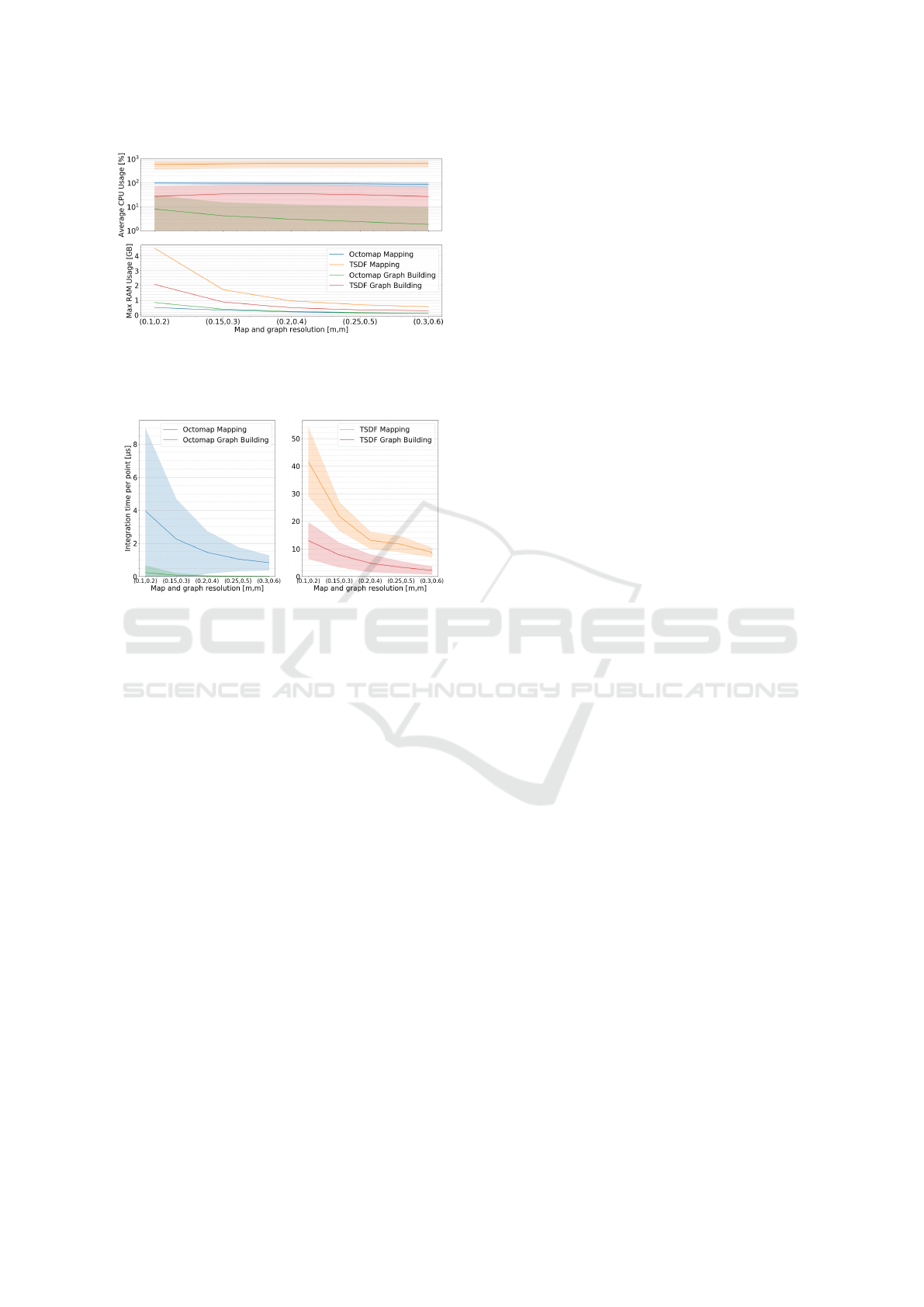
Figure 11: Average CPU usage (for 8 cores, full usage cor-
responds to 800 %) with standard deviation (log scale) and
max RAM usage for map and graph generation during the
entirety of the RELLIS-3D sequence 00000.
Figure 12: Average integration time per point with standard
deviation for map and graph generation with both mapping
methods from input LiDAR scans of the RELLIS-3D se-
quence 00000.
whereas the Octomap method is able to operate at data
production rate. In order to apply the TSDF method
to real-world embedded applications, smaller clouds
should be used in input, by reducing the maximum
integration distance or introducing a cut-out angle on
the LiDAR scans. A RGB-D camera or stereo rig with
a small image resolution could also be better suited
as it would produce more dense and spatially con-
strained data than a LiDAR, less costly to integrate
in a 3D map and a graph, with less voxels and nodes
to allocate or update at each scan.
6 CONCLUSIONS AND
PERSPECTIVES
This paper has presented an original system to jointly
optimize the process of online navigation using dense
semantic mapping. Two state-of-the-art semantic
mapping methods have been implemented and eval-
uated in this specific context, and the genericity of the
navigation algorithm allows for other semantic map-
ping and planning methods to be used. A closed-loop
simulation environment based on Ignition Gazebo has
been developed to be able to evaluate the mapping
as well as the navigation capabilities for autonomous
mobile robots in outdoor unstructured environments.
It relies on the 3DRMS-challenge dataset which pre-
sented the adequate features, but other datasets could
be processed in the same way to build a collection of
worlds in this contributed simulation setup with the
same semantic rendering and evaluation characteris-
tics.
The architecture has been evaluated in this setup
under the addition of various controlled levels of noise
on both localisation and semantic segmentation to
demonstrate the accuracy of the reconstructed map
and the ability to navigate using the underlying navi-
gation graph. As an application of this architecture in
a more advanced task, an exploration application has
been performed in closed-loop simulation to highlight
the capability of SMaNa to navigate avoiding specific
terrain types that could be hazardous. Finally, an ex-
periment on real data using the RELLIS-3D dataset
has been conducted to validate the usability of SMaNa
in a real scenario. The capacity to run in real-time
has also been evaluated and this shows that the Oc-
tomap mapping method is better suited for large out-
door navigation than the TSDF, however the above-
mentioned uncertainty study suggests that the TSDF
method evaluated is more robust to localisation and
segmentation noise than the Octomap one.
This first development and evaluation of a joint
online semantic mapping and navigation architecture
for unstructured environment opens many new possi-
bilities for real-world deployment. In particular, the
proposed SMaNa architecture could be extended with
a compatible visual-Lidar SLAM for unstructured en-
vironment. In order to deploy the architecture in a
real-world scenario, the training and implementation
of a semantic segmentation network from relevant
sensor data should be carried out to generate seman-
tic clouds. Moreover, the evaluation results of the dis-
crete explicit mapping methods applied to robot navi-
gation presented in this paper highlight some of their
limitations, which could be mitigated by the use of a
dedicated continuous implicit representation. Simu-
lation environments based on semantic generation ca-
pabilities such as the OAISYS architecture (M
¨
uller
et al., 2021) can also be considered for more exten-
sive evaluations in critical environments such as those
encountered during extra-planetary missions.
REFERENCES
Achanta, R., Shaji, A., Smith, K., Lucchi, A., Fua, P., and
Susstrunk, S. (2012). Slic superpixels compared to
ICINCO 2023 - 20th International Conference on Informatics in Control, Automation and Robotics
462

state-of-the-art superpixel methods. IEEE transac-
tions on pattern analysis and machine intelligence, 34.
Achat, S., Marzat, J., and Moras, J. (2022). Path planning
incorporating semantic information for autonomous
robot navigation. In 19th International Conference
on Informatics in Control, Automation and Robotics
(ICINCO), Lisbon, Portugal.
Bartolomei, L., Teixeira, L., and Chli, M. (2020).
Perception-aware path planning for uavs using seman-
tic segmentation. In IEEE/RSJ International Confer-
ence on Intelligent Robots and Systems (IROS), pages
5808–5815.
Behley, J., Garbade, M., Milioto, A., Quenzel, J., Behnke,
S., Stachniss, C., and Gall, J. (2019). SemanticKITTI:
A Dataset for Semantic Scene Understanding of Li-
DAR Sequences. In IEEE/CVF International Conf. on
Computer Vision (ICCV).
Bouman, A., Ginting, M. F., Alatur, N., Palieri, M., Fan,
D. D., Touma, T., Pailevanian, T., Kim, S.-K., Otsu,
K., Burdick, J., and Agha-Mohammadi, A.-a. (2020).
Autonomous Spot: Long-range autonomous explo-
ration of extreme environments with legged locomo-
tion. In IEEE/RSJ International Conference on Intel-
ligent Robots and Systems (IROS), pages 2518–2525.
Chen, X., Li, S., Mersch, B., Wiesmann, L., Gall, J., Behley,
J., and Stachniss, C. (2021). Moving Object Seg-
mentation in 3D LiDAR Data: A Learning-based Ap-
proach Exploiting Sequential Data. IEEE Robotics
and Automation Letters (RA-L), 6:6529–6536.
Cheng, Q., Zeller, N., and Cremers, D. (2022). Vision-
based large-scale 3D semantic mapping for au-
tonomous driving applications. arXiv preprint
arXiv:2203.01087.
Crespo, J., Castillo, J. C., Mozos, O. M., and Barber, R.
(2020). Semantic information for robot navigation: A
survey. Applied Sciences, 10(2).
Dosovitskiy, A., Ros, G., Codevilla, F., Lopez, A., and
Koltun, V. (2017). CARLA: An open urban driving
simulator. In Conference on Robot Learning, pages
1–16.
Ewen, P., Li, A., Chen, Y., Hong, S., and Vasudevan, R.
(2022). These maps are made for walking: Real-time
terrain property estimation for mobile robots. IEEE
Robotics and Automation Letters.
Grinvald, M., Furrer, F., Novkovic, T., Chung, J. J., Ca-
dena, C., Siegwart, R., and Nieto, J. (2019). Volumet-
ric Instance-Aware Semantic Mapping and 3D Object
Discovery. IEEE Robotics and Automation Letters,
4(3):3037–3044.
Grinvald, M., Tombari, F., Siegwart, R., and Nieto, J.
(2021). TSDF++: A Multi-Object Formulation for
Dynamic Object Tracking and Reconstruction. In
2021 IEEE International Conference on Robotics and
Automation (ICRA), pages 14192–14198.
He, K., Gkioxari, G., Dollar, P., and Girshick, R. (2020).
Mask R-CNN. IEEE Transactions on Pattern Analysis
and Machine Intelligence, 42(2):386–397.
Hornung, A., Wurm, K. M., Bennewitz, M., Stachniss,
C., and Burgard, W. (2013). OctoMap: An effi-
cient probabilistic 3D mapping framework based on
octrees. Autonomous Robots. Software available at
http://octomap.github.com.
Hua, B.-S., Pham, Q.-H., Nguyen, D. T., Tran, M.-K., Yu,
L.-F., and Yeung, S.-K. (2016). SceneNN: A scene
meshes dataset with aNNotations. In Fourth Interna-
tional Conference on 3D Vision (3DV), pages 92–101.
Hughes, N., Chang, Y., and Carlone, L. (2022). Hydra: A
real-time spatial perception system for 3D scene graph
construction and optimization. In Robotics: Science
and Systems (RSS).
Jiang, P., Osteen, P., Wigness, M., and Saripalli, S. (2021).
RELLIS-3D dataset: Data, benchmarks and analysis.
In IEEE international Conference on Robotics and
Automation (ICRA), pages 1110–1116.
Kantaros, Y., Kalluraya, S., Jin, Q., and Pappas, G. J.
(2022). Perception-based temporal logic planning
in uncertain semantic maps. IEEE Transactions on
Robotics, 38(4):2536–2556.
Kazhdan, M., Bolitho, M., and Hoppe, H. (2006). Pois-
son surface reconstruction. In Proceedings of the
fourth Eurographics symposium on Geometry pro-
cessing, volume 7, page 0.
Krstini
´
c, D., Braovi
´
c, M.,
ˇ
Seri
´
c, L., and Bo
ˇ
zi
´
c-
ˇ
Stuli
´
c, D.
(2020). Multi-label classifier performance evaluation
with confusion matrix. Computer Science & Informa-
tion Technology, 1.
Lambert, J., Liu, Z., Sener, O., Hays, J., and Koltun, V.
(2020). MSeg: A composite dataset for multi-domain
semantic segmentation. In Computer Vision and Pat-
tern Recognition (CVPR).
Martins, R., Bersan, D., Campos, M. F., and Nascimento,
E. R. (2020). Extending maps with semantic and
contextual object information for robot navigation:
a learning-based framework using visual and depth
cues. Journal of Intelligent & Robotic Systems,
99(3):555–569.
Maturana, D. (2022). Semantic Mapping for Autonomous
Navigation and Exploration. PhD thesis, Carnegie
Mellon University.
McCormac, J., Handa, A., Davison, A., and Leutenegger,
S. (2017). SemanticFusion: Dense 3D semantic map-
ping with convolutional neural networks. In IEEE In-
ternational Conference on Robotics and automation
(ICRA), pages 4628–4635.
M
¨
uller, M. G., Durner, M., Gawel, A., St
¨
urzl, W., Triebel,
R., and Siegwart, R. (2021). A Photorealistic Terrain
Simulation Pipeline for Unstructured Outdoor Envi-
ronments. In IEEE/RSJ International Conference on
Intelligent Robots and Systems.
Nießner, M., Zollh
¨
ofer, M., Izadi, S., and Stamminger,
M. (2013). Real-time 3D reconstruction at scale us-
ing voxel hashing. ACM Transactions on Graphics
(TOG), 32.
Oleynikova, H., Taylor, Z., Fehr, M., Siegwart, R., and Ni-
eto, J. (2017). Voxblox: Incremental 3d euclidean
signed distance fields for on-board mav planning.
In IEEE/RSJ International Conference on Intelligent
Robots and Systems (IROS).
Ono, M., Fuchs, T. J., Steffy, A., Maimone, M., and Yen,
J. (2015). Risk-aware planetary rover operation: Au-
SMaNa: Semantic Mapping and Navigation Architecture for Autonomous Robots
463

tonomous terrain classification and path planning. In
2015 IEEE Aerospace Conference, pages 1–10.
Qi, C. R., Su, H., Mo, K., and Guibas, L. J. (2017). Point-
net: Deep learning on point sets for 3D classification
and segmentation. In IEEE conference on Computer
Vision and Pattern Recognition (CVPR), pages 652–
660.
Ravichandran, Z., Griffith, J. D., Smith, B., and Frost, C.
(2020). Bridging scene understanding and task exe-
cution with flexible simulation environments. arXiv
preprint arXiv:2011.10452.
Rosinol, A., Abate, M., Chang, Y., and Carlone, L. (2020).
Kimera: an open-source library for real-time metric-
semantic localization and mapping. In IEEE Intl.
Conf. on Robotics and Automation (ICRA).
Seymour, Z., Thopalli, K., Mithun, N., Chiu, H.-P., Sama-
rasekera, S., and Kumar, R. (2021). Maast: Map
attention with semantic transformers for efficient vi-
sual navigation. In IEEE International Conference
on Robotics and Automation (ICRA), pages 13223–
13230.
Song, Y., Naji, S., Kaufmann, E., Loquercio, A., and Scara-
muzza, D. (2021). Flightmare: A flexible quadrotor
simulator. In Conference on Robot Learning, pages
1147–1157.
Sun, N., Yang, E., Corney, J., and Chen, Y. (2019). Se-
mantic path planning for indoor navigation and house-
hold tasks. In Althoefer, K., Konstantinova, J., and
Zhang, K., editors, Towards Autonomous Robotic Sys-
tems, pages 191–201, Cham. Springer International
Publishing.
Takikawa, T., Acuna, D., Jampani, V., and Fidler, S. (2019).
Gated-SCNN: Gated shape CNNs for semantic seg-
mentation. In Proceedings of the IEEE/CVF Interna-
tional Conference on Computer Vision (ICCV), pages
5229–5238.
Tylecek, R., Sattler, T., Le, H.-A., Brox, T., Pollefeys, M.,
Fisher, R. B., and Gevers, T. (2019). The second work-
shop on 3d reconstruction meets semantics: Challenge
results discussion. In Leal-Taix
´
e, L. and Roth, S., ed-
itors, ECCV 2018 Workshops, pages 631–644, Cham.
Springer International Publishing.
Wang, C., Cheng, J., Chi, W., Yan, T., and Meng, M. Q.-
H. (2021). Semantic-aware informative path planning
for efficient object search using mobile robot. IEEE
Transactions on Systems, Man, and Cybernetics: Sys-
tems, 51(8):5230–5243.
Xuan, Z. and David, F. (2018). Real-time voxel based 3D
semantic mapping with a hand held RGB-D camera.
https://github.com/floatlazer/semantic slam.
Z
¨
urn, J., Burgard, W., and Valada, A. (2020). Self-
supervised visual terrain classification from unsuper-
vised acoustic feature learning. IEEE Transactions on
Robotics, 37(2):466–481.
ICINCO 2023 - 20th International Conference on Informatics in Control, Automation and Robotics
464
