
The Evolution of Anak Krakatoa Based on Landsat Imagery
Sartika, Yohanes Fridolin Hestrio, Kiki Winda Veronica and Galdita Aruba Chulafak
Aeronautics and Space Research Organization, National Research and Innovation Agency (BRIN), Jakarta, Indonesia
Keywords:
Anak Krakatoa, NDWI, Landsat, Image Processing.
Abstract:
The Anak Krakatoa is a small volcano located in the Sunda Strait, specifically between the islands of Java
and Sumatra, Indonesia. The Anak Krakatoa is currently still an active volcano. This mountain has erupted
many times and has undergone various changes in its height, shape, and area, with the last eruption in July
2022. This study shows the changes in Anak Krakatoa, especially its shape and size, based on Landsat remote
sensing data from 1990 to 2022. Landsat imageries used in this study are Landsat 5,7, and 8. To obtain
information on the site of Anak Krakatoa, it begins by separating the sea and land around the mountain using
the Normalized Difference Water Index (NDWI). After the land is detected, then the area is calculated. The
volcano reached its minimum area in 1988 and its maximum area in 2022.
1 INTRODUCTION
Anak Krakatoa is a volcano located in the Sunda
Strait between the islands of Java and Sumatra, In-
donesia (Giachetti et al., 2012). The Krakatoa vol-
cano erupted violently in 1883 and caused a tsunami
to run 41 m and caused up to 36000 fatalities (Mu-
taqin et al., 2019), and destroyed 295 settlements
around the Sunda Strait (Bruins et al., 2008). The
eruption also formed a caldera with a depth of 200
to 280 meters below sea level (Umbgrove, 1926).
Krakatoa Island initially consisted of several moun-
tains, namely Mount Rakata, Mount Danan, and
Mount Perboewatan, wherein the incident in 1883,
Mount Danan and Perboewatan erupted (Umbgrove,
1926; Whittaker et al., 1989). After Krakatoa erupted
in 1883, a new volcano appeared in 1927, later re-
ferred to as the Anak Krakatoa (Gardner et al., 2013).
Since Anak Krakatoa first appeared, it has been an
active volcano. Anak Krakatoa has been growing and
developing through volcanic activity. It emerged from
the sea in the same location as the original Kraka-
toa volcano. The emergence of Anak Krakatoa is
believed to have resulted from the same geological
processes that led to the formation of the original
Krakatoa volcano, namely the subduction of the Indo-
Australian Plate beneath the Eurasian Plate. The on-
going eruptions and lava flows from Anak Krakatoa
contribute to the island’s growth. The lava cools and
solidifies, creating new land that expands the size of
the island. Over time, this can significantly grow the
island’s area. However, it’s important to note that vol-
canic activity can also lead to sudden and destructive
events, such as explosive eruptions, landslides, and
tsunamis. Anak Krakatoa erupted 80 times through
effusive and explosive eruptions from 1927 until 2006
(Igan, 2006) with Surtseyan and Strombolian eruption
types (Ginting et al., 2021). In 2018 Anak Kraka-
toa erupted again and was the first eruption after the
1883 eruption, which also resulted in a tsunami (Grilli
et al., 2019). This tsunami also caused damage and
loss of life in the coastal areas of Lampung and Ban-
ten, Indonesia (Grilli et al., 2019). From a volcano
under the sea, Anak Krakatoa grew to about 300 m
above sea level before erupting in 2018 (Ye et al.,
2020). One of the remote sensing data that can be
used in observing the earth’s urface, and the data is
continuous, is Landsat. Landsat was launched in 1972
(Chen et al., 2020) and entered the ninth series in
2022 (Gross et al., 2022). However, not all regions
were recorded in its early mission due to its limita-
tions. For the Anak Krakatoa area, the data that can
be used is data from 1988. Observations and research
on Anak Krakatoa have certainly been very much
done, such as about the tsunami that caused it (Grilli
et al., 2019; Ye et al., 2020), the landscape (Ginting
et al., 2021), its growth (Igan, 2006), the vegetation
(Whittaker et al., 1989), the coral reef (Ferdiansyah
et al., 2019), and many more. This study was car-
ried out to observe the extensive development of the
volcanic island of Krakatoa. To obtain information
on the site of Anak Krakatoa, it begins by separating
60
Sartika, ., Hestrio, Y., Veronica, K. and Chulafak, G.
The Evolution of Anak Krakatoa Based on Landsat Imagery.
DOI: 10.5220/0012442500003848
Paper published under CC license (CC BY-NC-ND 4.0)
In Proceedings of the 3rd International Conference on Advanced Information Scientific Development (ICAISD 2023), pages 60-64
ISBN: 978-989-758-678-1
Proceedings Copyright © 2024 by SCITEPRESS – Science and Technology Publications, Lda.

the sea and land around the mountain using the Nor-
malized Difference Water Index (NDWI). Then, use
the Otsu method to monitor the Anak Krakatoa area.
This method can assist in the automatic tracking of
Anak Krakatoa in the future without human interven-
tion. Usually, monitoring is done using visual inter-
pretation.
2 MATERIALS AND
METHODOLOGY
2.1 Location
The research location is on the Anak Krakatoa Vol-
cano Island in the Sunda Strait, Indonesia, as shown
in Fig. 1. Mount Anak Krakatoa itself is administra-
tively located in the South Lampung Regency, Lam-
pung Province, Indonesia (Suwarsono et al., 2019).
Figure 1: The location of the study area, with the upper
inset showing the location of Sunda Strait in Indonesia and
the lower inset showing the location of Anak Krakatoa in
Sunda Strait.
2.2 Methodology
Figure 2 shows the flowchart of the method used for
the study.
Figure 2: Flowchart.
The method can be divided into several parts: data
selection, calculation of the NDWI, Delineation, and
Compute the area of Anak Krakatoa.
• Data Selection
The data used is Landsat data which consists
of several Landsat series, namely Landsat-5,
Landsat-7, and Landsat-8. These three types of
Landsat imagery have a spatial resolution of 30
meters but have a different numbers of bands. The
data selected is cloud and smoke-free, which can
show a clear boundary between Anak Krakatoa Is-
land and the ocean. The data consists of 5-year
intervals from 1988 to 2018 and 1-year intervals
from 2018 to 2022. The reason for choosing 5-
year data intervals is because the eruptions be-
tween these ranges were not too significant until
2018, while the 1-year data is to see more spe-
cific changes per year that occurred after the ma-
jor eruption in 2018. The data used is shown in
Table 1.
Table 1: List of dates and types of Landsat satellites used.
Date Landsat
Type
Date Landsat
Type
1988-03-04 Landsat-5 2018-12-20 Landsat-8
1993-09-26 Landsat-5 2019-11-05 Landsat-8
1998-12-13 Landsat-5 2020-04-29 Landsat-8
2003-05-09 Landsat-7 2021-08-06 Landsat-8
2008-05-30 Landsat-5 2022-07-08 Landsat-8
2013-09-01 Landsat-8
• NDWI
Normalize Difference Water Index (NDWI) is a
method that enhances the water’s presence while
eliminating the presence of vegetation and soil in
remote sensing data (McFeeters, 1996). NDWI
utilizes the NIR channel, which is strongly ab-
sorbed by water and strongly reflected by vege-
tation and soil (McFeeters, 1996). The formula of
NDWI can be seen in equation (1).
NDWI =
GREEN − NIR
GREEN + NIR
(1)
For Landsat-5 and 7, GREEN and NIR are located
in Band 2 and 4, respectively (Chander et al.,
2004; Markham et al., 2004). While in Landsat-
8, the GREEN and NIR are located in Band 3
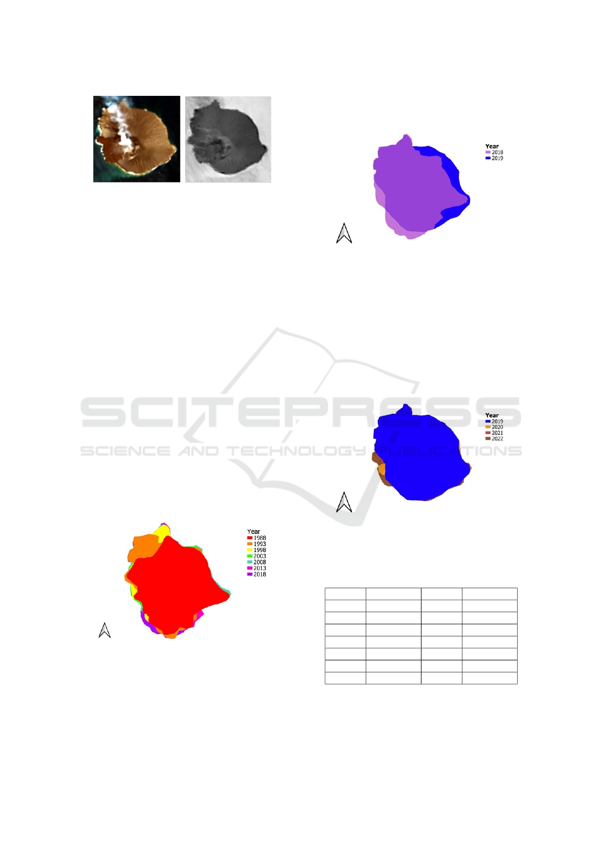
and 5, respectively (Wang et al., 2017). Figure
3 shows the comparison between the data in RGB
and NDWI.
• Delineation
The delineation is done using manual rather than
automatic delineation or thresholding techniques.
The manual delineation is used because the condi-
tion of Anak Krakatoa itself is pretty active, so in
addition to considering cloud conditions, it must
also consider smoke conditions. In NDWI, it can
eliminate soil and vegetation presence but also
The Evolution of Anak Krakatoa Based on Landsat Imagery
61
,
Figure 3: The comparison between the RGB (left) and
NDWI (right) shows that the soil has a darker area than the
water.
eliminate clouds and smoke so that when auto-
matic delineation is carried out, clouds and smoke
will also be detected as land (Choi et al., 2022).
Because of this, it is necessary to select data en-
tirely free of smoke and clouds if using an auto-
mated method, especially the one that intersects
with the coast. Indeed, this will significantly limit
the data that can be used. This deficiency due to
cloud and smoke can be reduced by using SAR
data such as Sentinel-1, but the data availability
is not as much as Landsat data, which Sentinel-
1 was only available in 2014 (Wegn
¨
uller et al.,
2016).
3 RESULTS AND DISCUSSION
Changes in the Anak Krakatoa area from 1988 to
2018 as shown in Fig. 4. As can be observed from
1988, the lava flow was more directed to the north
with a significant addition of area from 1988 to 1993.
From 1998, the additional area was more inclined to-
wards the west and south of the island, although not
as wide as the change in previous years.
Figure 4: The change in the area of Anak Krakatoa from
1988 to 2018.
Figure 5 shows the changes that occurred before
and after the eruption in 2018. Here, it can be ob-
served that a region vanishes in the western portion
of the island while there is an expansion of the region
in the eastern part. The increase in the area in the
east region could be caused by ocean currents carry-
ing eruptive material in that direction.
Figure 5: The change of Anak Krakatoa before and after the
eruption on December 2018. The increase and loss of area
have happened in several locations.
Meanwhile, Fig.6 illustrates the shift in the Anak
Krakatoa region between 2019 and 2022. The west is
where the changes are more pronounced. Naturally,
the lava flow entering the region and causing changes
cannot be separated. In other areas, not too much
change has happened. If there are changes such as
abrasion and accretion in other areas of Anak Kraka-
toa, it is most likely due to the influence of ocean cur-
rents.
Figure 6: The change of Anak Krakatoa from 2019 to 2022.
The changes in the area that occurred in Anak
Krakatoa can be seen in Table 2.
Table 2: The area of Anak Krakatoa.
Year Area (ha) Year Area (ha)
1988 251.727 2019 325.936
1993 264.571 2020 328.266
1998 293.334 2021 322.320
2003 295.039 2022 333.550
2008 296.609
2013 300.691
2018 306.829
It is clear that between 1988 and 2018, the area
expanded to 55.102 ha, and from 2019 and 2022, the
area increased to 7.16 ha. The most significant in-
ICAISD 2023 - International Conference on Advanced Information Scientific Development
62
crease in area is from 2021 to 2022 at 11.23 ha. Al-
though the increase in area from 1988 to 1993 was
greater (12,844 ha), it occurred for five years or had
an average rise of 2.59 ha/year. The fact is that Anak
Krakatoa’s condition has increased yearly in the area
even though there was an eruption in 2018. However,
there is also a decrease in the area from 2020 to 2021,
probably due to soil or rock conditions that are still
unstable and easily carried away by ocean currents.
The growth of the detected vegetation area from 1988
to 2018 also experienced an increase in area. The veg-
etation in Anak Krakatau is on the east side. After the
2018 eruption until 2022, no vegetation has been seen
through Landsat imagery on Anak Krakatoa. Figure
7 shows some of the vegetation conditions of Anak
Krakatoa through true composite color. Table 3 is an
estimate of the area of vegetated areas in Anak Kraka-
toa.
Table 3: Estimated area of vegetation in Anak Krakatoa.
Year Area (ha) Year Area (ha)
1988 23.388 2019 0
1993 36.232 2020 0
1998 52.657 2021 0
2003 57.484 2022 0
2008 61.033
2013 75.951
2018 76.091
Compared with its elevation, Anak Krakatoa loses
more in elevation than in area. In (Saputra et al.,
2021), it was stated that Anak Krakatoa’s height was
338 m to 110 m after the eruption. The condition
of the area certainly, in contrast, has increased from
around 306,829 ha to approximately 325,936 ha.
,
Figure 7: 1988 and 1998.
Figure 8. Vegetation condition (green area) of
Anak Krakatoa that shows the expansion until the
eruption in 2018.
,
Figure 8: 2008 and 2022.
4 CONCLUSION
The condition of the Anak Krakatoa continues to de-
velop from year to year in terms of its area. Despite
the eruption, the volcanic island’s area increased from
around 306.829 ha to approximately 325.936 ha while
its height decreased. During observations using Land-
sat data, the area of Anak Krakatoa had a minimum
size of 251,727 ha in 1988 (the earliest data used) and
a maximum area of 333,550 ha in 2022 (the latest data
that was used). The most significant increase in the
area occurred from 2021 to 2022, with an additional
area of 11.23 ha. For further research, a study will be
carried out using multi-sensor remote sensing data to
monitor Anak Krakatoa’s development.
ACKNOWLEDGEMENT
The authors would like to thank the Research Center
for Remote Sensing for providing the data used in this
study and the anonymous reviewers for their valuable
comments to improve this article.
REFERENCES
Bruins, H., MacGillivray, J., Synolakis, C., Benjamini,
C., Keller, J., Kisch, H., Kl
¨
ugel, A., and Plicht,
J. (2008). Geoarchaeological tsunami deposits at
palaikastro (crete) and the late minoan ia eruption of
santorini. J. Archaeol. Sci, 35:191–212.
Chander, G., Helder, D., Markham, B., Dewald, J., Kaita,
E., Thome, K., Micijevic, E., Ruggles, T., The, A.,
and Mapper (2004). L.-t.: Landsat-5 tm reflective-
band absolute radiometric calibration. IEEE Trans.
Geosci. Remote Sens, 42:2747–2760.
Chen, F., Fan, Q., Lou, S., Yang, L., Wang, C., Claverie, M.,
Wang, C., Junior, J., Goncalves, W., and Li, J. (2020).
Characterization of mss channel reflectance and de-
rived spectral indices for building consistent landsat
1-5 data record. IEEE Trans. Geosci. Remote Sens,
58:8967–8984.
Choi, Y.-J., Ban, H.-J., Han, H.-J., and Hong (2022). S.:
A maritime cloud-detection method using visible and
The Evolution of Anak Krakatoa Based on Landsat Imagery
63

near-infrared bands over the yellow sea and bohai sea.
Remote Sens, 14:793.
Ferdiansyah, M., Widiastuti, E., Ismail, T., and Susanto
(2019). G.n.: Inventarization of coral reefs in the wa-
ters of rakata island, krakatau islands. AQUASAINS,
8:775.
Gardner, M., Troll, V., Gamble, J., Gertisser, R., Hart, G.,
Ellam, R., Harris, C., and Wolff (2013). J.a.: Crustal
differentiation processes at krakatau volcano. Indone-
sia. J. Petrol, 54:149–182.
Giachetti, T., Paris, R., Kelfoun, K., and Ontowirjo (2012).
B.: Tsunami hazard related to a flank collapse of anak
krakatau volcano, sunda strait, indonesia. Geol. Soc.
London, Spec. Publ, 361:79–90.
Ginting, F., Gusnidar, N., M., R., Minasny, B., and Fiantis,
D. (2021). Changes in anak krakatau landscape after
december 2018 eruption. IOP Conf. Ser. Earth Envi-
ron. Sci, 708:012088.
Grilli, S., Tappin, D., Carey, S., Watt, S., Ward, S., Grilli,
A., Engwell, S., Zhang, C., Kirby, J., Schambach,
L., and Muin, M. (2019). Modelling of the tsunami
from the december 22, 2018 lateral collapse of anak
krakatau volcano in the sunda straits, indonesia. Sci.
Rep, 9:11946.
Gross, G., Helder, D., Begeman, C., Leigh, L., Kaewmanee,
M., and Shah (2022). R.: Initial cross-calibration of
landsat 8 and landsat 9 using the simultaneous under-
fly event. Remote Sens, 14:2418.
Igan, S. (2006). Pertumbuhan gunung api anak krakatau
setelah letusan katastrofis 1883. Indonesia. J. Geosci,
1:143–153.
Markham, B., Thome, K., Barsi, J., Kaita, E., Helder, D.,
and Barker, J. (2004). Scaramuzza, p.l.: Landsat-
7 etm+ onorbit reflective-band radiometric stability
and absolute calibration. IEEE Trans. Geosci. Remote
Sens, 42:2810–2820.
McFeeters, S. (1996). The use of the normalized difference
water index (ndwi) in the delineation of open water
features. Int. J. Remote Sens, 17:1425–1432.
Mutaqin, B., Lavigne, F., Hadmoko, D., and Ngalawani
(2019). M.n.: Volcanic eruption-induced tsunami in
indonesia: A review. iop conf. ser.earth environ. Sci,
256:012023.
Saputra, I., Armijon, A., and Fadly (2021). R.: Anali-
sis perubahan topografi gunung anak krakatau pasca
erupsi tanggal 22 desember 2018 menggunakan data
foto udara dan demnas. J. Geod. Geomatics, 1:43–55.
Suwarsono, N., Prasasti, I., Nugroho, J., Sitorus, J., and
Triyono (2019). D.: Detecting the lava flow deposits
from 2018 anak krakatau eruption using data fusion
landsat-8 optic and sentinel-1 sar. Int. J. Remote Sens.
Earth Sci, 15:157.
Umbgrove, J. (1926). The first days of the new subma-
rine volcano near krakatoa. Leidse Geol. Meded,
2:325–328.
Wang, Q., Blackburn, G., Onojeghuo, A., Dash, J., Zhou,
L., Zhang, Y., and Atkinson (2017). P.m.: Fusion
of landsat 8 oli and sentinel-2 msi data. IEEE Trans.
Geosci. Remote Sens, 55:3885–3899.
Wegn
¨
uller, U., Werner, C., Strozzi, T., Wiesmann, A.,
Frey, O., and Santoro, M. (2016). Sentinel-1 sup-
port in the gamma software. Procedia Comput. Sci,
100:1305–1312.
Whittaker, R., Bush, M., and Richards, K. (1989).
Plant recolonization and vegetation succession on
the krakatau islands, indonesia. Ecol. Monogr,
59:59–123.
Ye, L., Kanamori, H., Rivera, L., Lay, T., Zhou, Y., Sianipar,
D., and Satake, K. (2020). The 22 december 2018
tsunami from flank collapse of anak krakatau volcano
during eruption. Sci. Adv, 6:1–10.
ICAISD 2023 - International Conference on Advanced Information Scientific Development
64
