
Implementation of Computer Vision in Asphalt Damage Identification on
the Trans-Sumatera Road
Soleh Darmansyah
1
, Rika Rosnelly
1
and Hartono
2
1
Computer Science Masters Study Program, Faculty of Engineering and Computer Science, Potential Utama University,
Medan, Indonesia
2
Informatics Engineering Study Program Faculty of Engineering, Medan Area University, Medan, Indonesia
Keywords:
Road, Asphalt, Machine Learning, Decision Tree, K-Nearest Neighbor.
Abstract:
Roads are infrastructure made to facilitate land transportation in connecting one area to another. In general,
roads in Indonesia use asphalt as a material in the road construction process. The cross-Sumatra route is one
of the accesses that plays an important role in increasing economic progress in areas that connect areas on
the island of Sumatra. The development of computer vision using various image recognition classification
methods results in more accurate data accuracy. The Decission Tree and K-Nearest Neighbor methods in
image recognition classification of asphalt damage can be a solution in identifying damage and measuring the
area of damage through machine learning from images taken from the field. The design and implementation of
making applications is continued using the Decission Tree method using python as a programming language.
Asphalt damage conditions are divided into three classification categories of asphalt damage, namely mild,
moderate and severe. The results of the identification can be used as a report or field survey of the damage
conditions that occur on the Sumatra route. The accuracy value of the training is carried out using a dataset of
560 images. The Decission Tree method can get light damage 99.3damage, the accuracy value is 99.3for light
damage is 79.12accuracy from Machine learning carried out in this study show the highest accuracy value
obtained from the Decission Tree method in identifying road damage.
1 INTRODUCTION
In road inspections it is usually carried out by officers
who go into the field by measuring and recording the
types of damage that occur in the field and then tak-
ing pictures as report material. Road damage caused
by various factors causes road conditions to become
damaged quickly and is not feasible, thus endangering
road users crossing the road.Potholes, cracks and dis-
tortions are most commonly found on Sumatran high-
ways. This is caused by several things, namely the
condition of the soil structure, asphalt cracks that are
left, standing water or flooding and landslides. The
trans-Sumatra route has land routes that often experi-
ence damage problems. Pruning process Along with
the advancement of technology, the use of humans in
surveys in the field can be supported by technology
that suits the needs in the field, making it easier to
make data and reports. With the development of com-
puter vision which is from the development of com-
puter science technology that can work like humans
(Dompeipen et al., 2021), the inspection and identi-
fication of roads that were previously done manually
can be done with digital image processing and digital
image processing candetermine the type and measure
road damage.
Factors that damage the road that occurs in the
field. in Indonesia there are four classes of roads in
accordance with Law no. 22 of 2009 concerning road
traffic and transportation. Until now, Public Works
Department workers and project consultants have not
used computer technology. During the process of
identifying road damage, it is still done manually to
find and determine the type of road damage. The
measurement process is carried out manually using a
simple measuring device (roll meter) with human as-
sistance. Detecting holes manually requires a lot of
effort and time (Aparna et al., 2022).
Research by Agus Irawan, Adi Pratomo, Mey
Risa, Heldiansyah (2016) entitled ”Design of Road
Asphalt Damage Detection System Through Video
Using Fast Fourier Transform” In research designing
a road asphalt damage detection system (Ouma and
Hahn, 2017) via video can make it more cost effec-
102
Darmansyah, S., Rosnelly, R. and Hartono, .
Implementation of Computer Vision in Asphalt Damage Identification on the Trans-Sumatera Road.
DOI: 10.5220/0012444500003848
Paper published under CC license (CC BY-NC-ND 4.0)
In Proceedings of the 3rd International Conference on Advanced Information Scientific Development (ICAISD 2023), pages 102-106
ISBN: 978-989-758-678-1
Proceedings Copyright © 2024 by SCITEPRESS – Science and Technology Publications, Lda.

tive, faster and more safe in the implementation of ob-
servation and evaluation of the condition of the road.
This study uses video footage of road asphalt and then
extracts it into image frames. By utilizing several ar-
eas the result of the sum of the Fast Fourier Transform
values (Ma et al., 2021) in the image is used as a dam-
age feature to classify the image of asphalt roads into
good, moderate, slightly damaged and heavily dam-
aged categories.
Computer vision is a science that uses image
processing (Oppong et al., 2022) to make deci-
sions based on images obtained from sensors. In
other words, computer vision aims to make the sys-
tem work automatically by ”seeing” images/videos
(Azhar et al., 2016). Common frameworks that are
commonly used in computer vision are: image ac-
quisition, pre-processing, feature extraction, detec-
tion/segmentation, high-level processing, and deci-
sion making. Seeing the complexity of the acquisi-
tion process up to decision making, the research in-
cludes two major stages, namely feature extraction
for edge detection (Vijayarajeswari et al., 2019) be-
tween objects and its application for object recogni-
tion, namely to identify the type of damage (Riana
et al., 2022) to asphalt roads, such as in the form of
potholes, corrugated, cracking and raveling and edge
scouring (Ouma and Hahn, 2017).
Asphalt damage image identification from the
dataset is divided into three categories of asphalt dam-
age classification, namely mild, moderate and severe.
(Chitale et al., 2020) With these three categories,
damage to asphalt with potholes, cracks and distor-
tion can be identified and processed through a ma-
chine learning digital image recognition system (Feng
et al., 2023). Machine learning is a computational
model that is currently widely used in various fields.
The Gabor filter is used to analyze the texture
(Hendrawan et al., 2019) or obtain features from the
images used in the dataset with various types of as-
phalt damage images to process the images to be
tested (Permadi et al., 2021). Then proceed with Dis-
crete Cosine Transform in image compression.
2 RESEARCH METHODS
In this study the authors carried out the research
method described in Figure 1 with the initial stages
starting from taking image acquisition, then entering
the Machine Learning Process starting from Prepro-
cessing, Segmentation, Classification Methods and
applications displaying the results and extent of dam-
age.
Figure 1: Research Method.
2.1 Data Collection
Asphalt image collection is done by taking pictures
directly in the field so as to get various types of dam-
age that occurs on the asphalt. The number of image
data tested was 550 data and the training data tested
were 300 images. From the results of the inspection
carried out, it was found that three types of damage
occurred, namely severe, moderate and light. To as-
sess the type of road damage using the SDI (Surface
Distress Index) method, the road performance scale is
obtained from visual observations (Singh and Gupta,
2019). The images obtained will be continued with
the segmentation process and preprocessing will be
carried out.
Figure 2: Result Type of Road Damage.
2.2 Preprocessing
The preprocessing stage is the stage of the digital im-
age processing process before the image features are
extracted. The process carried out using the GLCM
method is one of the methods used for texture fea-
ture extraction in images (14, ). The features used in
GLCM, GLCM features have a total of fourteen fea-
tures and this study uses ASM features of contrast,
difference, homogeneity, correlation, second corner
moment (ASM), and energy (Leonardo, 2020). The
author uses the ASM feature and uses this entropy
feature to detect the type of asphalt damage with the
equation used in the ASM feature as follows:
ASM =
N
∑
i=1
N
∑
j=1
p(i, j)
2
(1)
H = −
N
∑
i=1
N
∑
j=1
p(i, j)log
2
p(i, j) (2)
Implementation of Computer Vision in Asphalt Damage Identification on the Trans-Sumatera Road
103
2.3 Segmentation
Segmentation is performed to divide an image into
homogeneous regions based on certain similarity cri-
teria. (Li et al., 2022) The segmentation process uses
the Gabor Filter method. Gabor filters can be used to
detect asphalt damage. Gabor filter is one of the filters
that is able to simulate the characteristics of the hu-
man visual system in isolating certain frequencies and
orientations from the image (Coulibaly et al., 2022).
Gabor filter in extracting local features from images
(Waluyo et al., 2023). The Gabor filter equation can
be seen from the equation below.
G(x, y; f , θ, ψ, Y ) = exp −
x
′2
+Y
2
y
′2
2σ
2
cos2π f x
′
+ ψ
(3)
Where:
G(x, y; f , θ, ψ, Y ) : Gabor filter values at coordinates
(x, y).
x
′
= x cos θ + y sin θ and y’ = -x sin θ + y cos θ :
Rotation of coordinates with respect to angle θ.
f : The spatial frequency of the Gabor filter.
θ : Gabor filter orientation (in radians).
ψ : Gabor filter phase.
Y : Gabor filter aspect ratio.
σ : Gabor filter Gaussian variance.
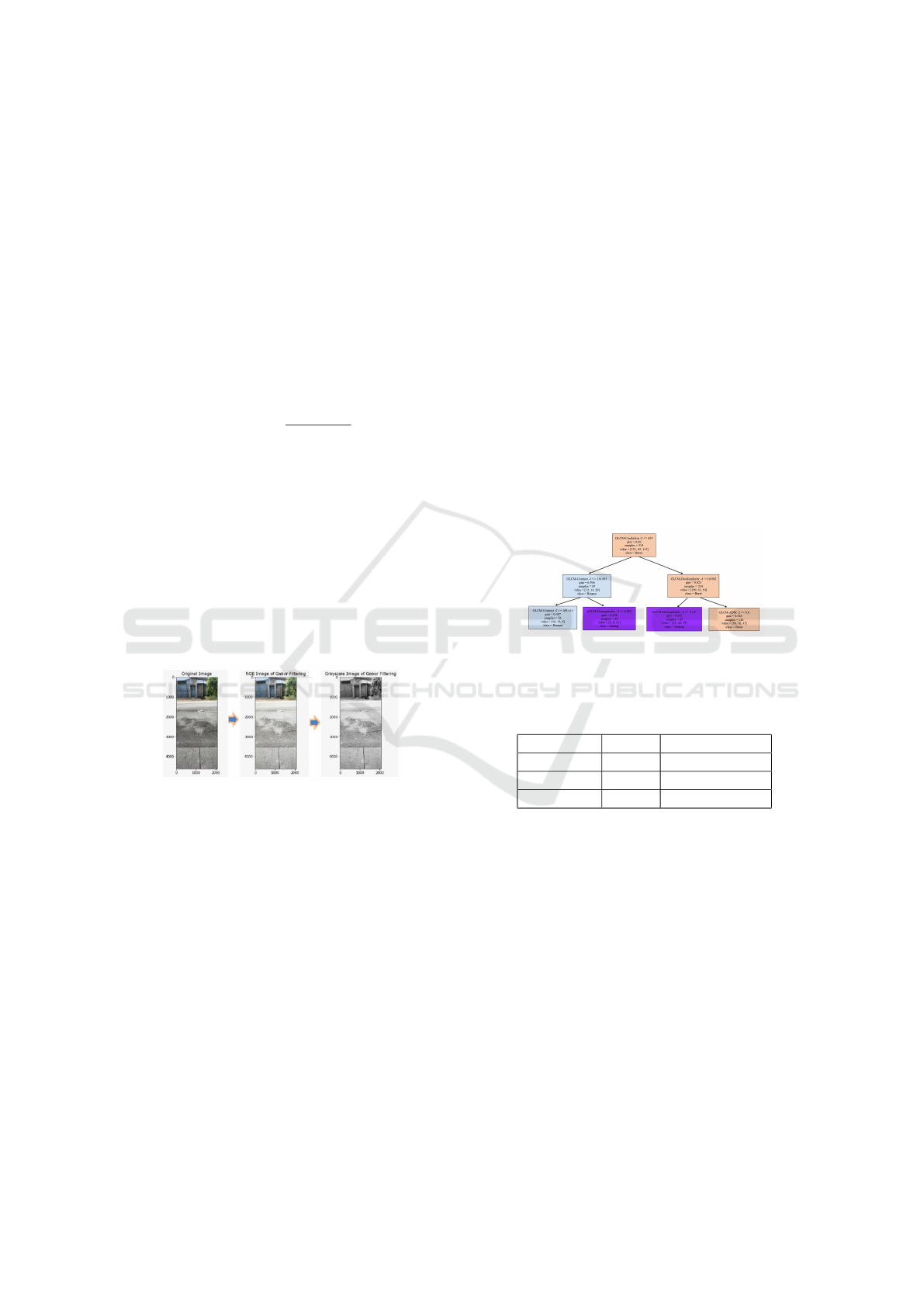
Figure 3: Process Result Changing Image.
2.4 Classification Method
The classification method in this study uses the two
Decission Tree methods and the K-Nearest Neighbors
Method to find the highest accuracy results. From
the results of the accuracy values of the two meth-
ods used, the method that produces the highest accu-
racy value will be used to create an application sys-
tem that can measure the type of damage and extent
of asphalt damage. The K-Nearest Neighbor method
is a new data grouping classification method based on
the distance of the new data with some of the closest
data or called data/neighbors (Coulibaly et al., 2022).
The K-Nearest Neighbors method is a method used to
classify objects based on training data that have the
closest distance to the test data object (Arfani, 2021).
The steps with the KNN method are started by enter-
ing: training data, training data labels, k, test data. All
testing data must be calculated the distance to each
test data with the Euclidian distance formula as in the
following equation.
d(x, y) =
n
∑
i=1
(x
i
− y
i
)
2
(4)
Where:
x
i
= sample data
y
i
= test data or training data
i = data variable
d(x,y) = dissimilarity/distance
n = data dimension
The Decision Tree method is a type of classifi-
cation that represents the shape of a tree structure.
Where each node represents the attribute, the branch
represents the value of the attribute, and the leaves
represent the class.
Figure 4: Process Result Changing Image.
Table 1: The results of the accuracy of training and test-
ing of image data carried out produce a comparison of the
accuracy values.
Categories K-NN Decission Tree
Lightly 97.1% 99.3%
Medium 87.8% 98.6%
Heavy 81.1% 99.3%
3 DATA AND APPLICATION
TESTING
On the initial page before starting the application, the
user can enter images to measure the extent of damage
to asphalt using the built application.
The machine learning process on images can rec-
ognize the type of image to then enter the process of
classifying the type of damage, asphalt damage cate-
gory and the system can calculate the area of asphalt
damage based on the pixel conversion value in meters
area unit.
The highest precision value of the type of groove
damage with the heavy damage category and the type
ICAISD 2023 - International Conference on Advanced Information Scientific Development
104
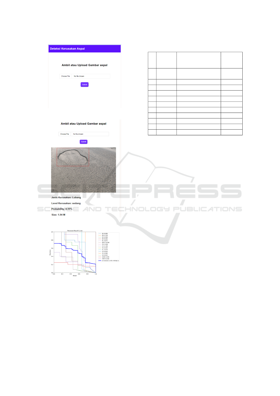
Figure 5: Initial Appearance of the Application.
Figure 6: Detection Results and Damage Area.
Figure 7: Precission-Recall Curve.
of curly damage with the moderate damage category.
Accuracy shows the accuracy of the results ob-
tained from the closeness of the value obtained with
the actual value. Precision is the suitability of the
data taken with the required information. Recall is
success in getting information back. F1-score is a
comparison of the average precision and recall (Qudsi
et al., 2020), (Kurniawan and Barokah, 2020). Precis-
sion Recall Curve results from the highest class label
Table 2: Precission-Recall Value Results.
No Damage Damage Precission
Type
Code
Category Type Recall
1 BA Groove Weight 0.995
2 BD Distortion weight 0.752
3 BH Severance Weight 0.507
4 BK Obesity Weight 0.202
5 BL Hole Weight 0.675
6 RH Broken Thirst 0.309
7 RL Light Hole 0.679
8 SD Moderate Distortion 0.655
9 SH Being Thirsty 0.995
10 SK Moderate Obesity 0.000
11 SKER Medium Curly 0.995
12 Straight Cracking 0.240
get the type of asphalt damage with heavy grooves,
medium wear and medium curly getting the highest
value, namely 0.995 while for light damage distor-
tion, light obesity and moderate obesity have a value
of 0.000 because the results of the image dataset did
not find the type of damage that read by the system.
In taking images in the field, it is necessary to
carry out technical training so that the images can be
appropriate and produce the best accuracy values, so
that the system can produce asphalt damage areas ac-
cording to the type and category of asphalt damage.
The shooting technique can be done by taking a 45
degrees angle towards the image object and can use
shooting with a slanted technique. In accordance with
the results of the accuracy of the KNN and Decission
Tree methods, the researchers decided to use the De-
cision Tree method as an image classification method
because it has better results and can develop accord-
ing to the type of asphalt damage.
4 CONCLUSIONS
In taking image acquisition, it is necessary to pay at-
tention to the distance of taking, the quality of light-
ing at the location and the perspective of the direction
of shooting because these factors become obstacles
that occur when the system conducts data training and
tests system results on applications in identifying the
type of damage and predicting the extent of the size
of the damage that occurs on asphalt. The Decission
Tree method and the K-NN method are widely used
to carry out image processing classification processes
and are applied to machine learning as a classification
model. The Decision Tree method is able to provide
results in the form of a decision tree which can be
Implementation of Computer Vision in Asphalt Damage Identification on the Trans-Sumatera Road
105

used as a reference in observing decisions made based
on the category of damage that occurs and is tested
by the system. Implementation of the best method
for the accuracy of asphalt damage identification re-
sults is made into a web-based application that can be
run offline or online. Based on the overall accuracy
test the results of the decision tree method show an
accuracy value of 98.6% and the KNN method gets
an overall accuracy value of 74.07%. This result is
obtained from the category of heavy damage to as-
phalt. The types of asphalt damage carried out in the
tests were carried out using images of groove dam-
age, distortion, fatness, wear and tear, curl, holes, and
cracks. The comparison of classifiers results that the
decision tree classifier gives the best accuracy value
from KNN.
ACKNOWLEDGEMENTS
The researcher would like to thank all parties involved
in this research, this research can be a solution and
simplify the field survey process for damaged road
conditions so as to simplify and speed up calculations
in predicting the need for asphalt repair materials in
the field.
REFERENCES
Aparna, Y., Rai, R., Gupta, V., Aggarwal, N., and Akula,
A. (2022). Convolutional neural networks based pot-
holes detection using thermal imaging. Journal of
King Saud University - Computer and Information
Sciences, 34:578–588.
Arfani, M. (2021). Implementasi computer vision pada de-
teksi dini kebakaran area spbu berbasis segmentasi.
Azhar, K., Murtaza, F., Yousaf, M., and Habib, H. (2016).
Computer vision based detection and localization of
potholes in asphalt pavement images. Institute of
Electrical and Electronics Engineers Inc.
Chitale, P., Kekre, K., Shenai, H., Karani, R., and Gala, J.
(2020). Pothole detection and dimension estimation
system using deep learning (yolo) and image process-
ing. IEEE Computer Society.
Coulibaly, S., Kamsu-Foguem, B., Kamissoko, D., and
Traore, D. (2022). Deep convolution neural network
sharing for the multi-label images classification. Ma-
chine Learning with Applications, 10:100422.
Dompeipen, T., Sompie, S., and Najoan, M. (2021). Com-
puter vision implementation for detection and count-
ing the number of humans,”jurnal. Teknik Informatika,
16:65–67.
Feng, L., Zhang, L., Gao, Z., Zhou, R., and Li, L. (2023).
Gabor-yolonet: A lightweight and efficient detection
network for low-voltage power lines from unmanned
aerial vehicle images. Frontiers in Energy Research,
10.
Hendrawan, Y., Widyaningtyas, S., and Sucipto, S.
(2019). Computer vision for purity, phenol, and
ph detection of luwak coffee green bean,”telkomnika.
Telecommunication Computing Electronics and Con-
trol, 17:3073–3085.
Kurniawan, Y. and Barokah, T. (2020). Klasifikasi penen-
tuan pengajuan kartu kredit menggunakan k-nearest
neighbor. Jurnal Ilmiah Matrik, 22:73–82.
Leonardo, L. (2020). Penerapan metode filter gabor untuk
analisis fitur tekstur citra pada kain songket. Jurnal
Sistem Komputer dan Informatika (JSON, 1:120.
Li, Y., Bi, Y., Zhang, W., Ren, J., and Chen, J. (2022). Color
image edge detection using multi-scale and multi-
directional gabor filter.
Ma, X., Shakoor, M., Vasiukov, D., Lomov, S., and Park, C.
(2021). Numerical artifacts of fast fourier transform
solvers for elastic problems of multi-phase materials:
their causes and reduction methods. Computational
Mechanics, 67:1661–1683.
Oppong, S., Twum, F., Hayfron-Acquah, J., and Missah,
Y. (2022). A novel computer vision model for medici-
nal plant identification using log-gabor filters and deep
learning algorithms. Computational Intelligence and
Neuroscience.
Ouma, Y. and Hahn, M. (2017). Pothole detection on as-
phalt pavements from 2d-colour pothole images using
fuzzy c-means clustering and morphological recon-
struction. Automation in Construction, 83:196–211.
Permadi, D., Widianto, W., and Hudayat, Y. (2021). Anali-
sis kondisi permukaan perkerasan jalan dengan meng-
gunakan metode survey sdi dan rci serta penanganan-
nya.
Qudsi, N., Asmara, R., and Syulistyo, A. (2020). Identi-
fikasi citra tulisan tangan digital menggunakan con-
volutional neural network (cnn. Seminar Informatika
Aplikatif Polinema, page 48–53.
Riana, D., Rahayu, S., Hadianti, S., Frieyadie, F., Hasan,
M., Karimah, I., and Pratama, R. (2022). Identifikasi
citra pap smear repomedunm dengan menggunakan k-
means clustering dan glcm. Jurnal RESTI (Rekayasa
Sistem dan Teknologi Informasi, 6:1–8.
Singh, G. and Gupta, P. (2019). Performance analysis of
various machine learning-based approaches for detec-
tion and classification of lung cancer in humans. Neu-
ral Computing and Applications, 31:6863–6877.
Vijayarajeswari, R., Parthasarathy, P., Vivekanandan, S.,
and Basha, A. (2019). Classification of mammo-
gram for early detection of breast cancer using svm
classifier and hough transform. Measurement: Jour-
nal of the International Measurement Confederation,
146:800–805.
Waluyo, W., Isnanto, R., and Rochim, A. (2023). Compar-
ison of mycobacterium tuberculosis image detection
accuracy using cnn and combination cnn-knn. Jur-
nal RESTI (Rekayasa Sistem dan Teknologi Informasi,
7:80–87.
ICAISD 2023 - International Conference on Advanced Information Scientific Development
106
