ACCESSING LOCATION AND PROXIMITY INFORMATION IN
A DECENTRALIZED ENVIRONMENT
Location Resolution Operations
Thomas Hadig
Stanford University, Stanford CA 94305, USA
Jörg Roth
University of Hagen, 58084 Hagen, Germany
Keywords: Location-based services, service infrastructures, positioning
Abstract: Location-aware applications take into account a mobile user's current location and provide location-depend-
ent output. Often, such applications still have to deal with raw location data and specific positioning systems
such as GPS, which lead to inflexible designs. To support developers of location-aware applications, we
designed the Nimbus framework, which hides specific details of positioning systems and provides uniform
output containing physical as well as semantic information. In this paper, we focus on two important opera-
tions provided by the framework, described by two questions "Where am I?" and "What is in my prox-
imity?" Our solution takes into account the requirements of clients in mobile environments. Our algorithms
are based on a decentralized and self-organizing runtime infrastructure and are, thus, highly scalable and
accessible for mobile users. We demonstrate the effectiveness of our approach by a number of simulations.
1 INTRODUCTION
Accessing information about the current location
will be an important service in future mobile and
ubiquitous application environments. Applications,
which take into account the current location, are
called location-aware applications; if we want to
focus on networked services, often the term loca-
tion-based services is used. Typical examples for
such applications are:
– Find the nearest hotel, hospital, or gas station?
How can I get there by bus or by car?
– My personal device (e.g. PDA, cell phone)
should remind me to check my tires when I enter
a gas station the next time.
– When I take a picture with my digital camera,
the location should be stored in the picture’s
meta data.
To support developers of such applications we
created the Nimbus framework. Nimbus provides a
common interface to location data and abstracts the
position capturing mechanisms. To achieve an opti-
mal flexibility, it provides physical coordinates as
well as semantic information about the current loca-
tion. With Nimbus, mobile users can switch between
satellite navigation systems such as GPS, positioning
systems based on cell-phone infrastructures, or in-
door positioning systems without affecting the loca-
tion-based service. A developer can, thus, concen-
trate on the actual service function and does not have
to deal with positioning sensors or capturing proto-
cols.
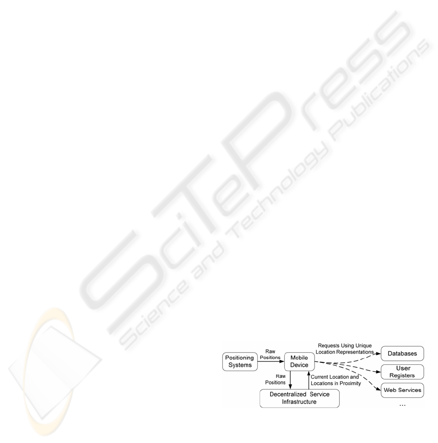
Figure 1: Data flow in the Nimbus framework
Fig. 1 shows the overall data flow in our frame-
work. A mobile device gets raw location data from
one or more positioning systems. Our framework
transforms these data and produces unique location
data using two basic operations, the location resolu-
88
Hadig T. and Roth J. (2004).
ACCESSING LOCATION AND PROXIMITY INFORMATION IN A DECENTRALIZED ENVIRONMENT - Location Resolution Operations.
In Proceedings of the First International Conference on E-Business and Telecommunication Networks, pages 88-95
DOI: 10.5220/0001382000880095
Copyright
c
SciTePress
tion and the proximity resolution. As these data have
a unique format, it can easily be used as a search key
to access databases, user registers, web services, etc.
In this paper, we describe the Nimbus framework
and focus on the resolution operations.
2 RELATED WORK
Many location-based applications and services have
been developed over the last years. Tourist infor-
mation systems are ideal examples for such applica-
tions. The systems CYBERGUIDE (Abowd et al.,
1997) and GUIDE (Cheverst et al., 2000) offer in-
formation to tourists, taking into account their cur-
rent location. Usually, such systems are bundled
with a general development framework, which
allows a developer to create other location-aware
applications. A second example for location-based
applications is context-aware messaging. Such sys-
tems trigger actions according to a specific location.
ComMotion (Marmasse et al., 2000) is a system
which links personal information to locations and
generates events (e.g. sound or message boxes),
when a user moves to a certain location. Cybre-
Minder (Dey and Abowd, 2000) allows the user to
define conditions under which a reminder will be
generated (e.g. time is "9:00" and location is
"office"). Conditions are stored in a database and
linked to users. Whenever a condition is fulfilled,
the system generates a message box.
Several frameworks deal with location data and
provide a platform for location-based applications.
Leonhardt (1998) describes a conceptual approach to
handle multi-sensor input from different positioning
systems. Cooltown (Kindberg et al., 2000) is a col-
lection of location-aware applications, tools and
development environments. As a sample application,
the Cooltown museum offers a web page about a
certain exhibit when a visitor is in front of it. The
corresponding URLs are transported via infrared
beacons. Nexus (Hohl et al., 1999) introduces so-
called augmented areas to formalize location infor-
mation. Augmented areas represent spatially limited
areas, which may contain real as well as virtual
objects, where the latter can only be modified
through the Nexus system. OpenLS (Open GIS) is
an upcoming project and provides a high-level
framework to build location-based services.
Location-based services will become increas-
ingly popular in the future. Especially mobile phone
providers expect a huge market for such services
(UMTS Forum, 2000). Typical applications respond
to questions like "Where is the nearest hotel?" or
"Which of my friends is in proximity?" Further
examples are city guides or navigation systems. The
first marketable service platforms come from the
mobile phone providers. Services such as Night-
guide or Loco Guide (Vodafone, 2003) serve as
location-based information portals based on WAP
technology. Such services reach a huge number of
users, but they have very coarse-grained tracking
capabilities still based on the GSM cell information.
Geographic information systems (GIS) and spa-
tial databases provide powerful mechanisms to store
and retrieve location data (Tomlin, 1990). Such sys-
tems primarily concentrate on accessing large
amounts of spatial data. In our intended scenarios,
however, we have to address issues such as connec-
tivity across a network and mobility of clients, thus
we have to use data distribution concepts, which are
only rarely incorporated into existing GIS ap-
proaches.
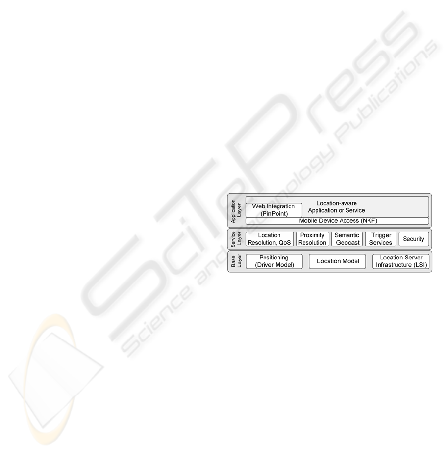
3 THE NIMBUS FRAMEWORK
We designed the Nimbus framework to simplify the
development of location-aware applications. Using
this framework, developers can concentrate on the
actual application function and can use location-
dependent services of our platform. We distinguish
three layers (fig. 2):
Figure 2: The Nimbus framework
The base layer provides basic services related to
positioning systems. The framework can use arbi-
trary positioning systems, ranging from satellite po-
sitioning systems, positioning with cell phone net-
works to indoor positioning systems, based on, for
example, infrared or ultrasound. To achieve the
required flexibility, we attach the positioning system
via a driver interface. This interface allows the
framework to switch between positioning systems at
runtime. The location model contains a formalism to
describe locations and a set of rules to model the
world. Finally, the Location Server Infrastructure
(Roth, 2003a) stores the location data and provides
services to access these data. It mainly consists of a
federation of so-called location servers, each storing
a piece of the entire location model.
The service layer provides higher-level location
services such as the location resolution and the
proximity resolution described in this paper. The
application can specify requirements concerning
ACCESSING LOCATION AND PROXIMITY INFORMATION IN A DECENTRALIZED ENVIRONMENT
89

precision and costs using quality of service parame-
ters (QoS). If more than one positioning system is
accessible at a certain location, the framework
selects an appropriate system according to the speci-
fied parameters. A further service of this layer is the
semantic geocast (Roth, 2003b) which extends the
original idea of physical geocasting. Trigger services
inform the application when a certain location was
reached. A set of security functions protect the users
and the framework against attacks.
The application layer contains the actual loca-
tion-aware application or service. A communication
middleware called Network Kernel Framework
(Roth, 2002a) was designed for small mobile
devices such as PDAs or cell phones and offers
communication primitives to access the servers. To
develop location-aware Web applications we offer a
high-level component called PinPoint (Roth,
2002b). As an example application, we developed a
Web-based tourist guide with PinPoint.
3.1 The Nimbus Location Model
The Nimbus location model contains a formal
specification of sets which describe locations, a set
of rules that define the relations between these sets,
and a set of operations that process location data.
Even though we express the model independently of
the later implementation, we strongly considered a
decentralized storage. Especially the operations
should be executed efficiently in a distributed fed-
eration of individual servers.
Semantic Locations: The concept of semantic
locations heavily influenced our model, thus we start
with a brief introduction of this concept. The notion
of semantic locations is not new (Pradhan, 2000):
besides physical locations such as GPS coordinates
we can consider semantic locations such as "John's
office at the university". Physical locations usually
can be expressed by numbers, semantic locations by
names.
Semantic locations are an ideal tool for a number
of applications, sometimes in combination with
physical locations. They have important advantages:
first, they have a meaning to the user; in contrast,
physical locations usually have no meaning at all to
most people. Second, they can easily be used as a
search key for traditional databases, tables or lists
without the need of spatial databases.
In this section, we want to relate semantic loca-
tions to physical locations. Let P denote the set of all
physical locations. We call each coherent area S
⊆ P
a semantic location of P. We further call each set C
⊆ 2
P
of semantic locations, a semantic coordinate
system of P. (2
P
denotes the power set of P.) Note
that we do not assume two semantic locations to be
generally disjoint. A reasonable semantic coordinate
system C contains semantic locations S with certain
meanings, e.g. countries, states, cities, districts,
streets, places, mountains, rivers, lakes, and forests.
We further introduce a name for a semantic
location. Let N be the set of all possible names. We
define a function NAME: C
→ N, which maps a
semantic location to a string. We require names to
be unique, i.e. NAME(c
1
) ≠ NAME(c
2
) for c
1
≠
c
2
.
We call a semantic location with its corresponding
name a domain. For a domain d, d.name denotes the
domain name, d.c the semantic location.
In principle, a semantic coordinate system C
could be an arbitrary subset of 2
P
that contains
coherent areas. Looking at real-world scenarios,
however, we usually find hierarchical structures,
e.g., a room is inside a building, a building is in a
city, a city is in a country, etc. Thus, we divide C
into hierarchies. A hierarchy contains domains with
a similar meaning, e.g., domains of cities or domains
of geographical items. Each hierarchy has a root
domain and a number of subdomains; each of them
can in turn be divided into subdomains. We call a
top node of a subhierarchy a master of the corre-
sponding subdomains. We denote m
>
s for master m
of subdomain s. Further
f denotes the reflexive and
transitive closure of > , i.e. d
1
f d
2
if either d
1
=d
2
or
d
1
is a top node of a subtree which contains d
2
.
We call a link between a subdomain and its
master a relation. Relations carry information about
containment of domains. Hierarchies are built ac-
cording to three rules:
– The area of a subdomain has to be completely
inside the area of its master, i.e. if d
1
>
d
2
then
d
2
.c
⊂
d
1
.c.
– The name of a subdomain d
2
extends the name of
its master d
1
according to the rule
d
2
.name=<extension> + '.' + d
1
.name, where
<extension> can be an arbitrary string containing
letters, digits and some special characters. With
the help of this rule, we can effectively check if
d
1
f d
2
or d
1
> d
2
with the help of the names.
– Root domain names of two hierarchies must be
different.
Figure 3: Sample hierarchies
Fig. 3 shows an example with two hierarchies. In
addition to relations, we use two more links: asso-
ciation and neighbourhood.
Associations: In principle, the model is now suf-
ficiently expressive to specify realistic sets of se-
ICETE 2004 - GLOBAL COMMUNICATION INFORMATION SYSTEMS AND SERVICES
90
mantic locations and their relationship among each
other. One important question could be: "Given a
physical location p, which semantic locations con-
tain p?" E.g., in fig. 3 point p resides in the domains
A, x.A, y.A, and a.y.A. As a master fully encloses a
subdomain, the results A and y.A do not carry useful
information. A useful answer would be x.A and
a.y.A.
This so-called location resolution could be per-
formed by browsing through all hierarchies from the
root down to the smallest domains covering p. This,
however, would cause a large number of requests
and in a real infrastructure a considerable amount of
network traffic. Therefore, we introduce a second
relationship between domains, the association:
Two domains d
1
, d
2
are associated, denoted
d
1
~d
2
, if they share an area, i.e. d
1
.c
∩
d
2
.c ≠ {} (con-
dition 1) and neither d
1
f d
2
nor d
2
f d
1
(condition 2).
Condition 2 prevents from superfluously linking
masters to their subdomains as they always share an
area. Associated domains can be in different hierar-
chies or in the same hierarchy (see fig. 3). Using
associations, we only need one domain d
0
that con-
tains the position p. All domains d~d
0
are candidates
to additionally contain p. In turn, no more domains
have to be checked, and thus we can avoid the time-
consuming search through all hierarchies.
We can reduce the number of candidates even
more because we are only interested in the most spe-
cific domains. If, in the example above, we want to
know which domains contain the point q, we are
only interested in the domains y.A and x.B, and not
in A or B. Taking this into account, we can modify
condition 1 as follows: associations only link two
domains, if the shared area is not fully covered by
their respective subdomains. This leads to the short
definition d
1
~d
2
iff
() ( )
{}
21
≠∆
∩
∆ dd , where
(
)
d
∆
denotes the area of d without its subdomains’ area.
In fig. 3, the shared area of A and x.B is fully
covered by the domain y.A, thus A and x.B are not
associated as this link would not carry additional
information. Starting at x.B we only have to check
y.A. Note we cannot always reduce the number of
queries. E.g. starting at y.A we have to check x.B
and B as there is an area of y.A∩ B outside of x.B.
Neighbourhood: In order to find locations in the
proximity of a mobile node, an additional type of
relationship is needed. If a mobile node leaves a
domain d
1
, its semantic location changes to a differ-
ent domain d
2
. Then, d
2
is called a neighbour of d
1
.
This means that either the areas of the two domains
overlap but d
1
does not contain d
2
or the areas have a
section of the boundary in common. Neighbourhood
links connect a domain and a subset of its neigh-
bours. The link is unidirectional. In the figures, we
indicate the direction of links by a dot: if d
1
refers to
a neighbour d
2
, the dot is shown at the line termina-
tion of d
2
.
Two domains are either related or associated, if
they overlap. In case of an association, no
neighbourhood link is necessary as they would carry
the same information. If the domains are related, the
subdomain is located inside the area of the master
domain; then, the subdomain can have a neighbour-
hood link to the master domain as the master covers
the entire border of the subdomain.
If several neighbours cover an overlapping part
of the domain border, it is sufficient to link only one
neighbour as other neighbours can be found by fol-
lowing the association and relation links of the
neighbour. For the example in fig. 3, the domain a.B
has the neighbours B, b.B and c.B. As B covers the
complete boundary, only this neighbourhood link is
necessary. In the case of b.B, a neighbourhood link
to a.B and c.B is necessary.
In the Nimbus framework, we implemented an
algorithm that searches the neighbours automati-
cally. During the start-up phase of a location server,
it searches for associated domains. After that, the
server checks for uncovered sections of the border
and actively searches domains that cover these sec-
tions. In addition, servers becoming unavailable due
to, e.g., network problems are automatically recog-
nized and replaced by other neighbours.
Of course, there are more links conceivable
between domains. We could, e.g. link two domains,
if they are connected by a street or a subway line.
We can store such links as meta data in a domain
record, but they do not have any influence on the
infrastructure. For the operations described later,
relations, associations and neighbourhood links are
sufficient.
3.2 The Runtime Infrastructure
Fig. 4 shows the distributed infrastructure which
consists of three segments:
Figure 4: The infrastructure
The positioning segment contains the positioning
systems, e.g., indoor positioning systems, satellite
navigation systems or systems based on cell phone
networks. The runtime system accesses the posi-
tioning systems through position drivers which al-
ACCESSING LOCATION AND PROXIMITY INFORMATION IN A DECENTRALIZED ENVIRONMENT
91

low the change of positioning systems even at run-
time. As many positioning systems provide local
positioning data, we may need the help of mapping
servers to transform local locations to global ones.
Each mapping server is responsible for a specific
positioning system, e.g., a mapping server inside a
building may be responsible for the indoor posi-
tioning inside this building. A lookup procedure
allows the mobile client to find the appropriate map-
ping server for a specific location, called the local
mapping server (LMS).
The user segment contains the mobile nodes with
a runtime system and the mobile part of the location-
based service. We developed a lightweight runtime
system for the mobile nodes. We shift heavy duty
tasks to the servers, thus the computational power of
PDAs or mobile phones is sufficient.
The server segment contains the location servers
that store the domain data. Each location server is
responsible for a specific domain and all subdo-
mains, for which no other location server exists.
When a mobile node moves to a specific location, it
automatically looks up an appropriate location
server for the new domain, called the local location
server (LLS). The LLS is the representative of the
infrastructure for a mobile node. As mobile users are
distributed among different location servers, this
infrastructure is highly scalable. It can be observed
that our system does not overload top-level servers.
We use a lightweight toolkit to process polygo-
nal data (Vivid Solutions, 2003). The toolkit handles
all geometric operations in the runtime memory and
can quickly check, if a point is inside or outside a
polygon. We store domain information using XML
files in which the most important entry is the poly-
gon specifying the area d.c. We can conveniently
edit these XML files with the help of a graphical
domain editor.
The entire system is self-organizing. A discovery
procedure presented in (Roth, 2003a) connects the
server to its domain master and looks up associated
servers and neighbours.
3.3 Resolution Operations
One goal of our approach is to provide uniform
location information, which is independent from the
actual positioning system. For each position, we
want to provide both physical as well as semantic
locations, even though typical positioning systems
only offer one type. GPS e.g. offers physical loca-
tions, whereas some indoor positioning systems
directly produce semantic location output. Having
both types, the application can choose the appropri-
ate type (or even both types) for the specific operat-
ing condition. We distinguish two resolution opera-
tions:
–
Location resolution: Given a physical location p.
What domains d
i
contain p? (semantic resolu-
tion). And in turn: Given a semantic location by
its name n. What is the physical extension d.c of
the domain d with this name? (physical resolu-
tion)
–
Proximity resolution: Given a physical location
p. What domains d
i
are inside a certain circle
around p.
The first kind of resolution is an operation with
two directions, both concerning the mobile user’s
current location. We could either ask for the physical
or semantic location, depending on the location data
provided by the positioning system.
The physical resolution is simple, as we only
have to look up the appropriate domain and return
d.c. The more complex operation is the semantic
resolution, as multiple hierarchies and domains may
be involved. The algorithm can be outlined as fol-
lows:
Look up an arbitrary domain d
0
with
()
0
dp ∆∈
names
←
{d
0
.name}
for all d~d
0
do
if
(
)
dp
∆
∈
names
←
names
∪
{d.name}
return names
If we have an arbitrary domain which fulfils the
first condition, we efficiently can loop through the
associated domains.
3.4 Proximity
The algorithm described above allows the user to
find information about his/her current physical and
semantic location. However, those do not provide
information about the proximity of the current loca-
tion. Questions like "Where are the closest restau-
rants?" cannot be answered. Therefore, an additional
proximity algorithm has been defined.
The basic idea of this algorithm is to search all
local domains and their neighbours in order to find
semantic domains that answer the question. The al-
gorithm is required to perform this search automati-
cally and efficiently. The following definitions are
used:
A match is a semantic domain that answers the
question. It is assumed that the test can be performed
by a filter using the semantic name of the domain.
This requires that all questions are given in form of a
regular expression that can be compared to the
domain name. Assuming a hierarchical structure of
ICETE 2004 - GLOBAL COMMUNICATION INFORMATION SYSTEMS AND SERVICES
92

domains describing restaurants with the master
domain restaurant.com, the question mentioned
before can be written as "Where are the closest
domains matching *.restaurant.com ?".
The distance of a semantic domain to the current
position of the mobile node is defined as the smallest
physical distance between the current position and
any point inside the area of the domain. We are
aware of other notions of distance. E.g. the distance
to a domain using a train may significantly differ
from our distance. At this point however, we assume
that distances can be computed by simply looking at
the domain area d.c. Other distances may use meta
data stored inside domain records.
One assumption is that the complete area is cov-
ered with domains, i.e., there is no location that
would not have a local location server. In addition, it
is also assumed that the questions include a search
limitation on the number of matches and/or on the
maximal search distance in order to prevent denial-
of-service attacks and erroneous requests from
causing a high load on the servers.
The algorithm uses the following strategy:
1.
Set the list of domains to search (D) to contain
only the local semantic domain.
2.
Beginning of a loop over all domains that have
not yet been searched. Iterate the following
points using the domain with the smallest dis-
tance as current domain.
3.
Query the location server of the current domain
for all its neighbours, subdomains, and associ-
ated domains.
4.
Remove those domains that have been searched
already from the returned list.
5.
Add all remaining domains to the list D of do-
mains to search.
6.
Apply the filter to the remaining domains. Those
domains that fulfil the requirement of the filter
are matches. In case of a match, the master do-
mains of the domain are also tested by the filter.
7.
Determine the distance d of the closest domain
in D.
8.
If the required number of matches with a dis-
tance smaller than d has been found, the algo-
rithm can terminate successfully.
9.
If the distance d is larger than the search distance
limit, the algorithm can terminate with an error
message.
10.
Start the next iteration of the loop in step 2.
Step 3 requires access to other location servers
across a network. Thus, this step needs a consider-
able amount of time compared to other steps. The
algorithm ensures that network queries are reduced
to a minimum (see section 3.6).
3.5 Proof of Correctness
In the following, a proof of correctness is sum-
marized. The complete formalism and proof cannot
be shown due to space considerations but is avail-
able from the authors.
A proof has to show that the algorithm termi-
nates and produces the correct result. As the matches
are found in an iterative procedure, it has to be
shown that all domains are checked during the itera-
tions and that the matches are found such that the
condition in step 8 returns the correct result. These
three items will be demonstrated below.
Termination: The algorithm will iterate over the
local domains until either the condition in step 8 or
step 9 is fulfilled. Especially, it is not possible that
the list of domains to search runs empty as each
point is covered by a local location server and, there-
fore, each domain can be reached from every other
domain by a path of neighbours, associated domains,
or subdomains.
In order to show the termination of the algo-
rithm, it is sufficient to demonstrate that one of the
conditions is reached in every case. This is true for
step 9. As the number of domains per unit of area is
finite, at some point, all domains within the search
radius have been reached and the next domain to
search is outside this limit.
Finding all domains: As described in the previ-
ous paragraph, there is a path between every pair of
domains. It can be demonstrated by induction on the
distance from the local domain that the algorithm
follows the possible paths in a breadth first search.
Thus, all domains are searched in the order of their
distance from the local domain.
Correctness of the results: As shown above, all
domains are searched. Therefore, all matches are
found. As the order of searching is done by distance
from the current domain, all matches with a distance
smaller than the distance of the current domain to
the local domain have been found. Therefore, the
condition in step 8 ensures that no other matches
closer than those returned exist.
3.6 Scalability and Simulation
It is important to understand the behaviour of the
algorithm in the case of a large number of domains
or a large number of requests.
In order to estimate the latter, the number of que-
ries to remote location servers for each request is
studied. It is assumed that the number of semantic
domains covering each point is approximately con-
stant as is the average size of those domains, i.e., the
number of domains per unit area f is a constant.
Then, for a search which ends at a distance r, the
ACCESSING LOCATION AND PROXIMITY INFORMATION IN A DECENTRALIZED ENVIRONMENT
93

algorithm has to search
2
rf ⋅⋅
π
domains. This
number of queries is minimal for a decentralized
environment. The size of the queries has been opti-
mized such that all necessary information is trans-
ported with as little overhead as possible. Assuming
an average length of the semantic domain name of
50 characters, the size of one query will be approxi-
mately 58 bytes for the request and for the answer
10 bytes plus 86 bytes for each neighbour returned.
Please note that this does not take into account the
overhead due to the TCP/IP protocol.
Similarly, the memory usage in the mobile node
has been optimized. An entry in the list of matches
or domains to search is approximately 66 bytes. The
number of entries in the list can be estimated using
the same arguments that were used for the band-
width. At a specific search distance
r
, all domains
with a distance smaller than
r
have been searched.
Therefore, those are no longer in the list of domains
to search. Searching those domains has added new
domains to the list that are directly neighbouring the
searched domains, i.e., they have a distance that is
larger than the current search distance by up to the
size of the domains searched. Assuming an average
domain size of
r
∆
, the list contains approximately
))((
22
rrrf −∆+⋅⋅
π
)2(
2
rrrf ∆+⋅∆⋅⋅=
π
do-
mains.
A simulation of the behaviour in a realistic envi-
ronment with several differently sized domains in
several hierarchies has been performed as a large
scale test. The location server definitions have been
extracted from the TIGER/Line (U.S. Census Bu-
reau, 2000) dataset from the U.S. Census Bureau.
This dataset provides area definitions for semantic
locations, such as political borders (state, county,
etc.), school districts, shopping centre, parks, rivers,
etc. From this data set, a subset of about 1300 loca-
tions in the San Francisco Bay Area has been used to
create configuration files for the location servers.
Table 1 gives an overview of the variety and
amount of configuration files created. As the crea-
tion has been automated, the configuration files for
all of the United States can be created which would
include 3232 counties and over 50,000 subdivisions.
In several simulation runs, a selection of the
location servers has been used to validate the algo-
rithm and determine the number of queries and the
size of the lists in the mobile node. For our simula-
tions we used five Linux computers inside a LAN
with up to 1.2 GHz CPUs and up to 512 MB RAM,
each of which stored a huge number of domains.
This however conflicts with our original idea of
decentralized data storage. On the one hand, we
could not measure long distance network transac-
tions, and on the other hand we overloaded single
servers. Especially the high memory load caused by
the number of server processes significantly reduced
the performance. Due to the limited size of the com-
puting power available for the simulation, no final
conclusion can be drawn on the real performance in
a completely decentralized environment. With the
simulations, however, we verified the algorithms
and its implementations. The results further confirm
the estimates given above for the bandwidth and
memory requirements.
3.7 Extensions
Several extensions of the algorithm are planed. On
the side of the user interaction, the algorithm can be
setup such that matches are returned to the user
immediately. This would allow the users to stop a
search once a successful match is found or to con-
tinue beyond the original search limit if no matching
domain is reached.
The use of call-back filters will allow the use of
information other than the semantic domain name
for describing the filter.
Bauer et al. (2002) proposed additional symbolic
links to express topological aspects or to express
proximity, which may be different from geometric
distance. Based on this idea, adding neighbourhood
links according to, for example, bus routes connect-
ing different domains could lead to a distance meas-
ures such as travel time. However, those links can no
longer be established by the algorithm but have to be
added to the location server configuration files.
Table 1: Overview of the type and number of the domain
definitions extracted from the TIGER/Line files
Semantic Name Number & Descript.
county.ca.us 4 Counties in California
name.county.ca.us 14 Subdivisions of counties
name.place.ca.us 67 Place (e.g. city)
name.amusement-center.com 6 Amusement centres
name.apartment.com 28 Apartment complexes
name.shopping-center.com 277 Shopping centres
name.airport.transport.com 7 Airports
name.train-station.transport.com 1 Train station
name.winery.com 4 Wineries
name.library.com 90 Libraries
name.elementary.district.school.edu 46 Elementary school district
name.secondary.district.school.edu 9 Secondary school district
name.unified.district.school.edu 15 Unified school district
name.individual.school.edu 174 Schools
name.golf-course.geo 22 Golf courses
name.island.geo 8 Islands
name.lake.geo 178 Lakes
name.river.geo 28 Rivers
name.park.geo 271 Parks
name.center.gov 4 Government service centres
name.medical.org 6 Hospitals
name.institutions.religious.org 6 Churches
name.cemetery.religious.org 33 Cemeteries
ICETE 2004 - GLOBAL COMMUNICATION INFORMATION SYSTEMS AND SERVICES
94

4 CONCLUSION AND FUTURE
WORK
In this article we introduced resolution operations
which provide unique location data independent of
the underlying positioning systems. We took into
account the distributed storage of location data in a
decentralized federation of location servers.
Developers of location-based services and appli-
cations can use the Nimbus framework as a platform
and do not have to deal with position capturing and
resolution. As the corresponding infrastructure is
self-organizing and decentralized, it is highly acces-
sible and scalable.
The framework provides methods to find all
semantic domains at the current position. In addi-
tion, proximity searches of the type "Where is the
closest restaurant?" are also supported. The data for
those searches is inferred from the semantic domain
name. This allows the Nimbus framework to answer
those queries without a central database or compli-
cated configurations on the server side. The algo-
rithm is open and easily extendable to more compli-
cated queries.
Finally, the whole system has been implemented
and tested using several hundred location server con-
figurations. A tool has been developed that allows
the automated creation of the XML configuration
files using the TIGER/Line dataset published by the
U.S. Census Board for the United States. Tests
established the scalability and correctness of the
algorithms.
REFERENCES
Abowd, G. D.; Atkeson, C. G.; Hong, J.; Long, S.; Kooper,
R.; Pinkerton, M., 1997. Cyberguide: A mobile
context-aware tour guide. ACM Wireless Networks, 3:
421-433
Bauer, M.; Becker, C.; Rothermel, K., 2002. Location Mo-
dels from the Perspective of Context-Aware Applica-
tions and Mobile Ad Hoc Networks, Personal and Ubi-
quitous Computing, Vol. 6, No. 5, Dec. 2002, 322-328
Cheverst, K.; Davies, N.; Mitchell, K.; Friday, A.;
Efstratiou, C., 2000. Developing a Context-aware
Electronic Tourist Guide, CHI'00, ACM Press
Dey, A., K.; Abowd, G., D., 2000. CybreMinder: A Con-
text-aware System for Supporting Reminders, Second
International Symposion on Handheld and Ubiquitous
Computing 2000, Bristol (UK), Sept. 25-27, 2000,
LNCS 1927, Springer-Verlag, 187-199
Hohl, F; Kubach, U.; Leonhardi, A.; Schwehm, M.;
Rothermel, K., 1999. Nexus - an open global infra-
structure for spatial-aware applications. 5th Intern.
Conference on Mobile Computing and Networking
(MobiCom '99), Seattle, WA, USA, 1999. ACM Press
Kindberg, T.; Barton, J.; Morgan, J.; Becker G.; Caswell,
D.; Debaty, P.; Gopal, G.; Frid, M.; Krishnan, V.; Mor-
ris, H.; Schettino, J.; Serra, B.; Spasojevic, M., 2000.
People, Places, Things: Web Presence for the Real
World, 3rd Annual Wireless and Mobile Computer
Systems and Applications, Monterey, USA, Dec. 2000
Leonhardt, U., 1998. Supporting Location-Awareness in
Open Distributed Systems, PhD Thesis, University of
London
Marmasse, N.; Schmandt, C., 2000. Location-aware In-
formation Delivery with ComMotion, Second Interna-
tional Symposion on Handheld and Ubiquitous Com-
puting 2000, Bristol (UK), Sept. 25-27, 2000, LNCS
1927, Springer, 157-171
Open GIS Consortium, OpenLS Home Page,
www.openls.org
Pradhan, S., 2000. Semantic Locations, Personal
Technologies, Vol. 4, No. 4, 2000, 213-216
Roth, J., 2002a. A Communication Middleware for Mobile
and Ad-hoc Scenarios, Int. Conf. on Internet Comput-
ing (IC'02), June 24-27, 2002, Las Vegas, Vol. I,
CSREA press, 77-84
Roth, J., 2002b. Context-aware Web Applications Using
the PinPoint Infrastructure, IADIS Intern. Conference
WWW/Internet 2002, Lisbon, Portugal, Nov. 13-15,
2002, IADIS press, 3-10
Roth, J., 2003a. Flexible Positioning for Location-Based
Services, IADIS Intern. Conf. e-Society 2003, Lisbon,
Portugal, June 3-6, 2003, IADIS Press, 296-304
Roth, J., 2003b. Semantic Geocast Using a Self-organizing
Infrastructure, Innovative Internet Community Systems
(I2CS), Leipzig, Germany, June 19-21, 2003, Springer-
Verlag, LNCS 2877, 216-228
U.S. Census Bureau, 2000. 108th Congressional Districts
Census, 2000, TIGER/Line Files,
http://www.census.gov/geo/www/tiger/index. html
Tomlin, C., D., 1990. Geographic Information Systems and
Cartographic Modelling, Prentice Hall
UMTS Forum, 2000. Enabling UMTS/Third Generation
Services and Applications, Report 11,
http://www.umts-forum.org, Oct. 2000
Vivid Solutions, 2003. JTS Technical Specifications,
http://www.vividsolutions.com, March 31, 2003
Vodafone Homepage, 2003. www.vodafone.com
ACCESSING LOCATION AND PROXIMITY INFORMATION IN A DECENTRALIZED ENVIRONMENT
95
