
STUDY OF DIFFERENT APPROACHES TO THE INTEGRATION
OF SPATIAL XML WEB RESOURCES
José E. Córcoles, Pascual González
Departamento de Informática Universidad de Castilla-La Mancha Campus Universitario s/n.02071.Albacete. Spain.
Keywords: Semantic Web, Integration, Spatial XML
Abstract: The research community has begun to investigate foundations for the nex
t stage of the Web, called Semantic
Web. Current efforts include the Extensible Markup Language XML, the Resource description Framework,
Topic Maps and the DARPA Agent Markup Language DAML+OIL. A rich domain that requires special
attention is the Geospatial Semantic Web. However, in order to approach the Geospatial Semantic Web, it is
necessary to solve the problem of developing an integration system for querying spatial resources stored in
different sources. In this paper, we study two different approaches to integrating spatial and non-spatial
information represented in the Geographical Markup Language (GML). The approaches studied follow
LAV (Local as View) integration. With this study we obtain the best approach to developing a real system
for querying GML resources stored in different sources.
1 INTRODUCTION
A domain that requires special attention is the
Geospatial Semantic Web (Egenhofer et al. 2002).
The enormous variety of encoding of geospatial
semantics makes it particularly challenging to
process requests for geospatial information. Work
led by the OpenGIS Consortium (OpenGIS, 1999)
addressed some basic issues, primarily related to the
geometry of geospatial features.
In order to approach the Semantic Geospatial Web,
i
t
is necessary to solve the problem of developing an
integration system for querying spatial resources
stored in difference sources. The user should view a
virtual spatial data repository in a given domain
without knowledge of the source in which each item
of data is located.
Tackling the integration of spatial information on the
Web i
s
not a simple task since, for example, the
sources may store large amounts of incomplete
spatial data, which may make it necessary to join the
results of queries with spatial joins. Thus, it is
necessary to apply efficient query processing
strategies that allow spatial joins to be made on the
Web (Shahabi et al. 2003). Therefore, the
application of spatial operators means a different
treatment with respect to the integration of XML
resources with only alphanumeric (non-spatial) data.
The main aim of this paper is: (1) to study two
arch
itectures
for integrating Spatial XML resources
(GML) obtained by modifying two existing
approaches, and (2) to compare each one, with the
aim of obtaining the best approach for developing a
real system for querying GML resources stored in
different sources. In our study the spatial
information is represented in the sources by GML
because it is an XML encoding for the transport and
storage of spatial/geographic information, including
both spatial features and non-spatial features. The
mechanisms and syntax that GML uses to encode
spatial information in XML are defined in the
specification of OpenGIS (OpenGIS, 2003). Thus,
GML allows a more homogeneous and flexible
representation of the spatial information.
Query mediation has been extensively studied in the
literatu
re for
different kinds of mediation models
and for the capabilities of various sources: in the
field of non-spatial integration there are several
approaches such as Tsimmis (Papakonstantinou et al.
1995), Information Manifold (Levy et al. 1996).
More directly concerned with the integration of
364
E. Córcoles J. and González P. (2004).
STUDY OF DIFFERENT APPROACHES TO THE INTEGRATION OF SPATIAL XML WEB RESOURCES.
In Proceedings of the Sixth International Conference on Enterprise Information Systems, pages 364-369
DOI: 10.5220/0002613303640369
Copyright
c
SciTePress

XML resources, it is worth noting C-Web Portal
(Amann et al. 2001) and (Amann et al. 2002). C-
Web Portal supports the integration of non-spatial
resources on the Web, and C-Web provides the
infrastructure for (1) publishing information sources
and (2) formulating structured queries by taking into
consideration the conceptual representation of a
specific domain in the form of an ontology. On the
other hand, (Amann et al. 2002) proposes a mediator
architecture for the querying and integration of Web-
accessible XML data resources (non spatial data). Its
contribution is the definition of a simple but
expressive mapping language, following a local as
view approach and describing XML resources as
local views of some global schema.
In relation to spatial data integration, there are
approaches developed by (Gupta et al. 1999) and
(Boucelma et al. 2002). (Gupta et al. 1999) extends
the MIX wrapper-mediator architecture for
integrating information from spatial information
systems and searchable databases of geo-referenced
imagery. (Boucelma et al. 2002) presents a
mediation system that addresses the integration of
GIS data tools, following a GAV(Global as View)
approach.
In order to design approaches for querying spatial
GML resources, we have based our work on two
existing studies: (Amann et al. 2002) and (Amann et
al. 2001) mentioned above. We have selected the
first approach ((Amann et al. 2002)) because it is
focused on integrating XML resources, and it can be
extended in a simple way to query GML resources
with spatial operators. The second approach has
been selected because it is an interesting approach
that makes it possible to query different resources on
the Web. By this we mean that modifying it adds the
possibility of querying GML resources. In addition,
both approaches follow a LAV (Local as View)
integration. The LAV approach facilitates the
maintenance of the integrated schema and
mediation, although query evaluation is far more
complex than the global-as-view approach where the
integrated schema is defined in terms of source
schemas. The LAV approach is therefore favoured
in the context of the integration of resources that
change significantly over time, such as Web
resources. In short, by modifying these contrasted
approaches we exploit the solution to query XML
data on the Web.
The overview of both architectures and the
modification applied to query spatial information are
shown in Section 2 and Section 3. In Section 4 we
conclude with a comparison of the two approaches,
emphasising the most important advantages and
disadvantages, in order to obtain the best approach
for developing a real system for querying GML
resources stored in different sources.
2 APPROACH BASED ON RDF
A Community Web Portal(Karvounarakis et al.
2000)(C-Web) essentially provides the means to
select, classify and access, in a semantically
meaningful and ubiquitous way, various information
resources (sites, documents, data) for diverse target
audiences (corporate, inter-enterprise, …). The core
Portal component is a Catalog holding descriptions,
i.e. metadata, of the resources available to the
community members. In order to effectively
disseminate community knowledge, Portal Catalog
organises and gathers information in a multitude of
ways, which are far more flexible and complex than
those provided by standard (relational or object)
databases. It uses the Resource Description
Framework (RDF) standard (Brickley et al. 2000)
proposed by W3C, designed to facilitate the creation
and exchange of resource descriptions between
Community Webs. In order to query the Catalog, a
query language, called RQL, is presented in
(Alexaki et al. 2001) which allows semistructured
RDF descriptions to be queried using taxonomies of
node and edge labels defined in the RDF schema.
In order to integrate the spatial information of
several spatial XML documents (GML), we have
based our work on the Community Web Portal
concept (Amann et al. 2001) with RDF and RQL, a
declarative language for querying both RDF
descriptions and related schemas. To perform this
integration, it is necessary to make some
modifications to the original approach because in the
original approach the Catalog is considered as a
collection of resources identified by URIs and it is
described using properties. However, it does not
need to use operator over the resources, only over
the properties.
GML documents (or part of) are a resource. Unlike
the original approach, it is possible to apply spatial
operators (comparatives: cross, overlap, touch;
analysis: Area, Length) over the resources provided
they represent geometry information with GML. In
order to take advantage of this fact, we have
designed two modifications with respect to the
original approach:
Extension of RQL to support spatial operators over
the resources that represent spatial documents or part
of spatial documents. These operators must be the
same as those defined in (Corcoles et al. 2001) for a
query language over GML. There are two types of
operators: methods for testing Spatial Relations and
methods that support Spatial Analysis. This
extension is not dealt with in this paper.
Extension of the Community Web Portal architecture
to support the application of the spatial operators
STUDY OF DIFFERENT APPROACHES TO THE INTEGRATION OF SPATIAL XML WEB RESOURCES
365
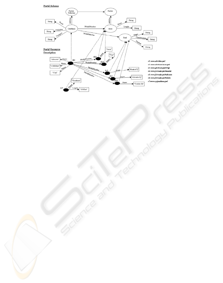
Figure 1: Portion of Catalog of a CityModel.
over the resources involved in the query, and the
integration of all information to be returned.
2.1 An Overview
In this section, an overview of the application of the
mediation system is given, looking at the system
from the point of view of the user. In Figure 1, an
example of the Portal Schema and its instances is
shown. The example has been obtained from the
specification documents of GML. Due to RDF’s
capability for adding new feature and geometry
types in a clear and formal manner, this example has
been carried out extending the geospatial ontology
defined by OpenGIS, where the class (Geometry,
LineString, etc) and properties (coordinates,
PolygonMember, etc) are defined. The example
shows an extension of a Catalog for a CityModel
proposed by (OpenGIS, 2003) and called
Cambridge.rdfs.
This is a well-known example used in all
specifications over GML and developed by
OpenGIS. The Cambridge example has a single
feature collection of type 'CityModel' and contains
two features using a containment relationship called
'modelMember'. The model member can be Rivers
that run through the City or Roads belonging to the
City.
An example of a query expressed in RQL extended
with spatial operators may be as follows:
“Find all Road resources that belong to Albacete
City and which are within 50 meters of a River of
this city ”.
In RQL:
Select Z
From {X}ModelMember{Y:River},
{W}ModelMember{Z:Road}, {P}name{Q}
Where X=W and X=P and Q=”Albacete” and
Crosses(Buffer(Y,50),Z)
In a different way to the original approach, this
query has a part that is executed directly over the
Catalog, and another part that is executed over the
objects Road and River stored in the respective
sources. In order to do this, it is necessary to
establish a spatial query plan. On the other hand, if
the query uses operators like Area, Length, Union,
Intersection, etc., this approach manages the new
created resources. The results could be the resources
(&r2 ,&r3).
Although the resources may be of different types
(documents, HTML files, Raster image,..), in this
approach the semantic of the spatial operators is
only applied over the geometry objects based on the
OpenGIS specification (OpenGIS, 1999).
This approach can be studied at length in [CG03]).
3 APPROACH BASED ON
MAPPING
In this section we present a general overview of the
second approach. This work has been inspired by
(Amann et al. 2002), which proposes a mediator
architecture for the querying and integration of Web-
accessible XML data resources (non spatial data). Its
contribution is the definition of a simple but
expressive mapping language, following a local as
view approach and describing XML resources as
ICEIS 2004 - DATABASES AND INFORMATION SYSTEMS INTEGRATION
366

local views of some global schema. This approach
offers its users a virtual data repository in a given
domain. This repository is virtual because the real
data resides in some external sources. However, the
users of the repository are not concerned with the
source location and source data organisation.
Obviously, our aims (integrate spatial sources) are
different from those of the previous work by
(Amann et al. 2002) (integrate non-spatial sources).
For this reason, (Amann et al. 2002) has been
extended in order to satisfy our requirements.
We present in the following section an overview of
the system architecture offered by (Amann et al.
2002). In subsection 3.2, we detail the main
modification of this approach to achieve spatial
queries.
3.1 Overview
The main task of an integration mediator is to
provide users with a unique interface for querying
the data, independently of its actual organisation and
location. This interface, or global schema, is
described as an ontology. As used here, an ontology
denotes a light-weight conceptual model and not a
hierarchy of terms or a hierarchy of concepts (in the
same way as in the first approach). The global
schema can be viewed as a simple object-oriented
data model. Hence, a global schema can be viewed
as defining a database of objects, connected by roles,
with the concept extents related by subset
relationships as per the isA links in the schema.
Since it is an integration schema, this is a virtual
database. The actual materialisation exists in the
sources.
To evaluate a user query expressed in terms of the
ontology, the approach translates it into one or more
queries on the XML sources. For this purpose, we
need to establish a correspondence between each
source and the global ontology. This correspondence
is described by a mapping, which is a collection of
mapping rules (path-to-path).
The description of the global schema in terms of the
ontology allows users to formulate structured
queries, without being aware of the source specific
structure. (Amann et al. 2002) illustrates querying
with the query language defining tree queries.
Although these queries have some limitations (e.g.
joins between variable are not allowed (Amann et al.
2002)), they are sufficiently powerful to illustrate
the issues of answering queries from XML source
data (but it is not sufficient to answer spatial
queries).
In order to process each query, two query processing
cases are possible. In the first case, the solution to a
query is the union of the complete answers from
individual sources. If no complete answer can be
obtained from a source, then the source is
abandoned. This simple strategy has obvious
advantages, as it only needs a variable binding
algorithm and a simple query execution plan for
searching all sources for which there exists a full
binding. In contrast, the second case also allows for
incomplete answers from a given source. If a source
s can only partially answer a query, then the query is
decomposed into two parts, one to be fully answered
by s and the other part being sent to the other
sources. In this case, it needs a variable binding
algorithm and a query execution plan that includes
query decomposition for searching all sources for
which there exists a full/partial binding.
3.2 Modification to query spatial
resources
Our modification includes two new components: (i)
spatial system, used to make the joins between the
results of spatial queries and (ii) Spatial DBMS,
where the spatial GML documents are stored over
ORDBMS (in the same way as the first approach).
In addition, other modifications have been made to
the functionality of the existing components: (iii)
extends the features of the query languages
including spatial operators and including spatial and
non-spatial joins, and (iv) extends the query
execution plan to query spatial joins (using the
spatial system component).
The query language used for querying in the original
approach should support spatial and non-spatial
operators with a user-friendly interface. Therefore,
in our modification we use another spatial query
language for GML (Corcoles et al. 2001) as the
query language used by the users and for querying
the different sources. Thus we have simplified the
translation between the user query and the queries
executed in each source. It is an advantage with
respect to (Amann et al. 2002). (Note that in the
original approach, a query language based on OQL
is shown.) A query is a simple tree query, based on
select-from-where clauses. We assume queries
satisfy the following restrictions regarding the
original algebra.
First, over the variables in the select clause it is
possible to apply spatial operators supported in the
original algebra: methods for testing Spatial
Relations and methods that support Spatial
Analysis(Corcoles et al. 2001). Second, as is
mentioned above, in the original approach the where
clause is a conjunction of simple predicates, where a
simple predicate is of the form x θ d in which θ ∈
{=, <,>,≤,≥}and d is an atomic value. Thus, it is not
possible to express joins by equalities between
STUDY OF DIFFERENT APPROACHES TO THE INTEGRATION OF SPATIAL XML WEB RESOURCES
367
variables, i.e. by predicates of the form x
i
= x
j
. In our
case, this limitation restricts the expressive power of
the query language and of this application. For this
reason, we have incorporated the possibility of
including spatial joins in the where clause (x
i
φ
x
j
|
φ
is a spatial join operator defined by (Corcoles et al.
2001); cyclic joins are not allowed). This facility
makes it more difficult to evaluate the queries than
in the original approach. For this reason, the
definition of a new algorithm (shown below) for
evaluating the query is necessary. Third, Spatial
Operators intersection, union, difference and
symdifference are not included. This restricts the
power of the query language but simplifies the
evaluation of queries. Last, the language has no
quantifiers, aggregates, or subqueries.
The result of such a query is a set of tuples of the
form {[a
i
, a
j
, …a
k
]}where a
i
, a
j
, …a
k
are instances of
the variables in the query’s select clause and can be
either atomic values or GML fragments.
Due to the extension of the original approach with
spatial and non-spatial joins, a third query
processing case should be added in this
modification. This case allows for incomplete
answers from a given source and all variables
involved in spatial join operators (or non spatial)
are found in different sources. It is the most
complete and complex case. It needs (i) a query
execution plan that includes query decomposition
for searching all sources for which there exists a
full/partial binding, (ii) a solution for joining the
results of each partial query, and (iii) a strategy for
performing spatial joins on the web sources. For this
reason we have developed a new query execution
plan, which is described in the following section.
3.3 Query Execution Plan
This Section describes a query execution plan that
includes query decomposition for searching all
sources for which there exists a full/partial binding
and a strategy for performing spatial joins on the
web sources.
In a distributed environment with restricted access to
the remote servers (the remote servers are read-
only), performing spatial join queries must be
simulated by spatial select operations after
transferring whole/partial data sets from the local to
the remote server. In addition, the query response
time is a function of size and complexity of the data
transferred between the servers. (Shahabi et al.
2003) provides an approach to performing spatial
joins in a Web environment. Based on this work, we
have adopted the following query processing
strategy to solve spatial joins. Local refers to the
mediator and Remote refers to the remote sources.
(i) Local: Local to Remote Transfer {Dinamic-
MBR}, (ii) Remote: Spatial Selection {Window-
Selection}, (iii) Remote: Send to Local {Candidate
Objects} and, (iv) Local: Refinement {Pipelined}.
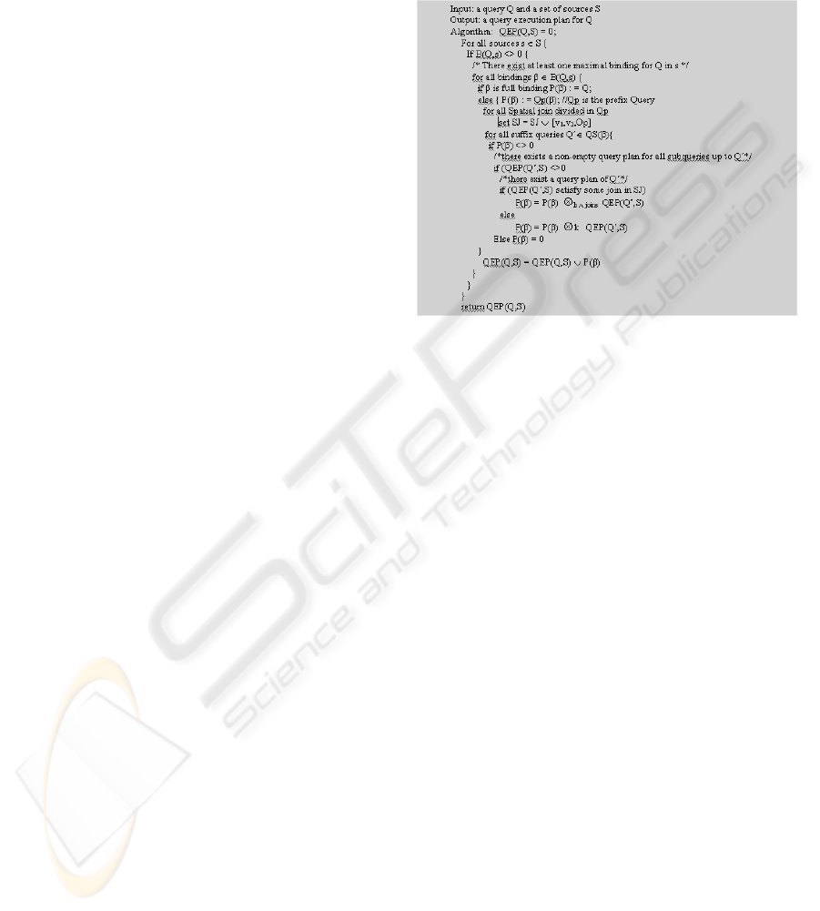
Given a set of sources S and a query Q, the
algorithm P(Q) shown in figure 2 computes a Query
Execution Plan for Q. For each source s and a
maximal binding β ∈ B(Q,s), a QEP P(β) is
computed: if β is a full binding (i.e complete
answers are obtained), the result is query Q.
Otherwise, if β is a partial binding, then query Q is
decomposed into a prefix query Q
p
(β) and a set of
suffix queries QS(β). All spatial joins divided in the
prefix query are registered. It is necessary to know
when a partial query satisfies a spatial join and then
carry out the join in the QEP. The query execution
plan of Q against source s is obtained by joining
Q
p
(β) with the query execution plan for each suffix
query Q´∈ QS(β) (variable k denotes the key query
variables of Q´). To calculate the query execution
plan of a suffix query Q’, the algorithm is called
recursively. Finally, the plan obtained is added to the
existing plan by union.
Figure 2: Query Execution Plan Generation.
Note that there are two reasons for interrupting the
calculation of a query execution plan for a given
source s and binding β. The most trivial case is that
there exists no maximal binding for Q in s. The
second reason is that there exists at least one suffix
query which cannot be satisfied (empty query
execution plan).
4 CONCLUSIONS
Each approach has advantages and disadvantages.
With the modification incorporated in the first
approach it is possible to obtain an architecture that
enables the integration of different kinds of
ICEIS 2004 - DATABASES AND INFORMATION SYSTEMS INTEGRATION
368

resources (documents, sites, GML resources,...)
using a unique query language RQL that allows
querying of a Catalog with references to all
resources. In addition, this approach (and the second
approach) allows GML resources to be queried
efficiently in each source, because they store the
GML documents in ORDBMS(Corcoles et al. 2002).
These are just some of the features offered by the
first approach.
No doubt, this approach is the best approximation to
the Geospatial Semantic Web, querying all kinds of
resources in the same way. However, this alternative
has several disadvantages: (1) the query language
used by the user (RQL) is different from the query
language used by the wrappers. For this reason,
several conversions are necessary between query
languages (RQL to QL over GML and QL over
GML to QL of the DBMS); (2) the rewriting
algorithm to translate the RQL query to XML
queries over the local sources is complex to
implement.
The second modification offers a more powerful
alternative for querying spatial resources. It solves
some disadvantage of the first approach: (1) the use
of only one query language to query the ontology
(users) and to query the GML resources in the
wrappers. The approach architecture allows a more
powerful query language than the modification of
RQL; (2) different strategies are contemplated in this
approach, including spatial joins between objects
localised in resources of different sources. This
approach uses strategies for carrying out joins
efficiently between large spatial data on the Web.
Finally, both approaches also has the disadvantage
of administering the mapping rules between the
ontology and the sources.
In conclusion, an approach with advantages of both
alternatives is the more powerful alternative for
developing a system to query spatial XML resources
on the Web. The implementation of a usable
prototype has already been achieved.
REFERENCES
Amann B., et al.. 2002 Ontology-Based Integration of
XML Web Resources. In International Semantic Web
Conference (ISWC), Sardinia, Italy.
Alexaki. S et al. 2001. “The ICSFORTH RDFSuite:
Managing Voluminous RDF Description Bases”. In
Proceedings of the 2nd International Workshop on the
Semantic Web (SemWeb'01), in conjunction with
WWW10, pp. 1-13, Hong Kong.
Amann, B. et al. 2001. Mapping XML Fragments to
Community Web Ontologies. In Proc. Fourth
International Workshop on the Web and Databases.
Boucelma, O, et al. 2002. A WFS-Based Mediation
System for GIS Interoperability. ACM-GIS 2002. 10th
ACM International Symposium on Advances in
Geographic Information Systems. McLean (USA).
Brickley, D , et al. 2000. Resource Description Framework
(RDF) Schema Specification 1.0, W3C Candidate
Recommendation. Technical Report CR-rdf-schema-
20000327, W3C, Available at
http://www.w3.org/TR/rdf-schema.
Córcoles J, et al. 2001. A Specification of a Spatial Query
Language over GML. ACM-GIS 2001. 9th ACM
International Symposium on Advances in Geographic
Information Systems. Atlanta (USA).
Córcoles J, et al. 2002. Analysis of Different Approaches
for Storing GML Documents ACM-GIS 2002. 10th
ACM International Symposium on Advances in
Geographic Information Systems. McLean. (USA).
Córcoles J, et al. 2003. Querying Spatial Resources. An
Approach to the Semantic Geospatial Web. CAiSE'03
workshop (WES2003).
To Appear in Lecture Notes in
Computer Science (LNCS)
by Springer-Verlag.
Egenhofer M. 2002. Toward the Semantic Geospatial
Web. ACM-GIS 2002. 10th ACM International
Symposium on Advances in Geographic Information
Systems. McLean (USA).
OpenGIS. 2003. Geography Markup Language (GML)
v3.0. http://www.opengis.org/techno/documents/02-
023r4.pdf.
Gupta, A, et al.. 1999. Integrating GIS and Imagenery
through XML based information Mediation. Integrated
Spatial Databases: DigitalImages and GIS. Lecture
Notesin Computer Science. Vol1737. Pp. 211-234.
Springer-Verlag.
Karvounarakis, G, et al. 2000. Querying community web
portals. Technical report, Institute of Computer
Science, FORTH,Heraklion, Greece.
http://www.ics.forth.gr/proj/isst/RDF/ RQL/rql.pdf.
Levy,A. Y, 1996. Querying Heterogeneous Information
Sources Using Source Description. In Proc. of the Int.
Conference on Very Large Databases, pp.25-262.
India.
OpenGis Consortium. 1999. Specifications.
http://www.
opengis.org/ techno/specs.htm
Papakonstantinou, Y, et al. 1995. Object Exchange Across
Heterogeneous Information Sources. In Proc. ICDE
Conf. TSIMMIS project: http://www-
db.standford,edu/tsimmis.
Shahabi, c, et al. 2003. Alternative Strategies for
Performing Spatial Joins on Web Sources,
To Appear
in Journal of Knowledge and Information Systems
(KAIS) by Springer-Verlag
,
STUDY OF DIFFERENT APPROACHES TO THE INTEGRATION OF SPATIAL XML WEB RESOURCES
369
