
Handling Heterogeneity in Context Aware Services
Ronald van Eijk
1
, Arjan Peddemors
1
, Johan de Heer
1
, Alfons Salden
1
,
Petri Määttä
2
, Ville Haataja
2
1
Telematica Instituut, PO Box 589, 7500 AN Enschede, The Netherlands, www.telin.nl
2
VTT Electronics, Telecommunication Systems, P.O. Box 1100, FIN-90571, Oulu, Finland
Abstract. The increasing number of context aware applications, sensing
technologies and positioning algorithms ask for a generic framework that is
able to handle the large heterogeneity in contextual information. Thereto, we
propose a layered context model that describes the heterogeneity in location
information and a reference architecture that contains Distributing Servers and
Location Operation Servers. The proposed framework can support location
services in a heterogeneous environment. Finally we demonstrate the viability
of our framework by implementing parts of our architecture related to a
location service. Our service makes use of two different positioning
technologies, based on WLAN and Bluetooth infrastructures respectively.
1 Why is there a Need for Handling Heterogeneity?
The present variety of positioning technologies for indoor as well as outdoor settings
is large and the diversity of targeted end-users, devices and applications they have
been developed for is growing as well. Originally many specific user groups and
professions have required highly limited and restricted navigation tools. These
technologies have been developed according to specific application requirements but
after being implemented they have found broader use, i.e. use by other types of
applications. However, the applications are specifically proprietary and not easy to
use in other network environments. Furthermore, for these different environments
other positioning technologies, e.g. based on wireless local area network or mobile
phone base station networks have been developed. There is extensive literature about
positioning technologies, location information representation and how to deal with
location information. For an overview of positioning technologies we refer to [1] and
[2]. An excellent overview of location modelling work can be found in [3]. A few
important research results will be discussed here.
The solutions mentioned here are not technology and application independent.
Therefore, we will define a framework that is both technology and application
independent. Our solution will be capable of dealing with the whole process of
sensing the location, processing and combining location information and distributing
it to interested entities. In our view there are two major functional requirements that
have to be satisfied by our envisioned generic framework, namely:
van Eijk R., Peddemors A., de Heer J., Salden A., Määttä P. and Haataja V. (2004).
Handling Heterogeneity in Context Aware Services.
In Proceedings of the 1st International Workshop on Ubiquitous Computing, pages 18-27
DOI: 10.5220/0002656300180027
Copyright
c
SciTePress

• Handling heterogeneity of sensing technologies, among which are those for
positioning, e.g. positions may be calculated from the network or determined
from sensors or beacons.
• Sustainability of contextual parameters, e.g. parameters describing the
situation of a group of users being in a meeting
In line with these functional requirements we aim in this work to combine two
positioning technologies that are not compatible with each other, i.e. they do not
support the same coordinate system and their methods for determining and
representing location information are significantly different. However in many future
scenarios some of these technologies or like in some cases, all of them, are embedded
or attached to the same physical device, e.g. a PDA or laptop. In other words different
applications running on one device have to be able to use different technologies or
even combine location information that comes from these different technologies. This
can only be done if the details of the technology are shielded from the application,
and location information is always communicated in a way that the application
understands. This makes it a challenge to develop an application or a service that is
able to use all possible positioning technologies to acquire location information in
every situation and as accurate as possible in a generic way that is independent of the
technical details of the positioning technology.
In the next section we propose a context model that is required to describe and model
the heterogeneity in location information. When location information has to be
communicated between clients and servers, intelligent Distribution Servers and
Location Operation Servers have to be defined. Therefore, we propose a reference
architecture for intelligent location handling in section 3. In section 4 we describe our
implementation of a Location Service to demonstrate our ideas. This service makes
use of two totally different positioning technologies and shows how our framework
can handle heterogeneity in location information caused by various positioning
technologies. In section 5 we draw conclusions on our ideas and our implementation.
2 A Five Layer Context Model
In order to share contextual information with other applications and users, contexts
need to be represented in a generic way to a certain degree. This requires knowledge
modelling with respect to contexts. Dey et al. [5] pointed out that context models have
always been application dependent. Hence, there are not really generic context models
suitable for all kinds of applications. For our purposes we will use a context model in
order to define context levels (different levels of abstraction); mappings and
operations on contextual representations; reuse in applications; roaming between
different positioning technologies.
In particular we follow the context model given by Ailisto et al. [9] and apply their
context model for location information services using different positioning
technologies. In their model different abstraction levels are defined for context
processing objects and the location information that they produce (see Fig. 1). In this
19
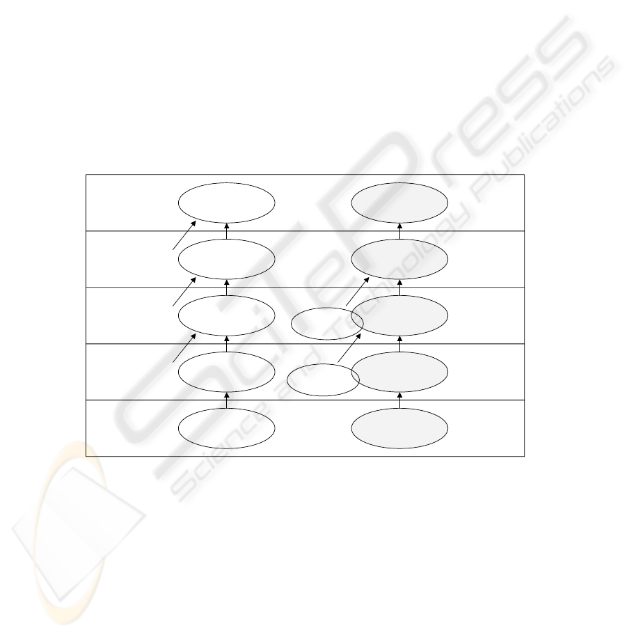
model information is processed and combined by objects at different levels as
follows: (1) On a physical level, position is measured by hardware equipment, e.g. by
a terminal or sensors observing signal strengths or Cell Ids, respectively. (2) On the
data level, this information is processed and new data is computed, e.g. the absolute
location of an object in x,y coordinates. (3) On the semantic level semantic
information is collected (for example references to other places in the world) and used
to enrich the location data and produce location information that is more meaningful
and understandable to both applications and human users. (4) On the inference level,
information is used from the semantic level, history information and inference rules,
possibly dynamically learned, to make educated guesses what the user is doing and
what kind of services he might want. (5) On the application level, decisions are made
about taking actions triggered by situations defined at the inference level.
It should be noted that location information on a higher abstraction level may
combine input from one or more sources of information defined at lower levels. This
is indicated in Fig. 1 by input arrows.
Sensor
Data processing
Object
Semantic processing
object
Inference
object
Application
Level 1: Physical
Level 2: Data
Level 3: Semantic
Level 4: Inference
Level 5: Application
Sensor output
Processed data
Semantic information
Inferred result
Context levels
Location example
WLAN
Hardware
Positioning Server
Building Map
Server
Presence Server
Instant Messaging
Signal Strength
x,y coordinate
Room number
User is in room
User
Identification
Building map
database
Fig. 1. Layered context model. Adapted from [9].
3 A Reference Architecture for Location Information Handling
Because high-level applications and users cannot deal with low-level sensor data, it is
necessary to introduce a reference architecture that collects raw sensor information,
translates it to an application-understandable format, and disseminates it to interested
20

applications or end-users. In this section we present such a reference architecture that
makes use of our context model presented in Section 2. Note that other reference
architectures are possible that could support our same context model, because our
model is not dependent of any architecture.
First, we describe the components of a physical frameworks and their functionality.
Second, we describe in more detail the two main architectural components: Location
Operation Servers and Distribution Servers. Finally, we give an example to illustrate
the roles of the components in an intelligent location handling system.
3.1 System Architecture and its Functional Components
For our system architecture we were inspired by the layered architecture of the TEA-
system [4] and the Context Toolkit [5]. The following components form the basis of
an architecture that can be used to determine position, to exchange location
information and to present it to users and applications:
• Positioning units. For example the user’s device itself that has a hardware
interface to perform measurements or that can receive information from
sensors in the environment. These units produce physical information, e.g.
signal strength. Two ways are possible (and might even be mixed): sensory
data coming from the user's device and sensory data coming from devices in
the user’s neighbourhood (e.g. WLAN access points).
• Location Operation Servers. Servers that can transform, adapt, pre-process
and do calculations on location information.
• Distribution Servers. These servers have the task to collect, store and
distribute location information according to queries.
• Client devices. The client device will be equipped with different
communication interfaces (GPRS, WLAN) and different positioning
technologies (GPS, WLAN, Bluetooth beacons).
Together, these entities are part of an architecture, in which location information is
requested, obtained, forwarded, processed etc. The roles of Location Operation
Servers and Distribution Servers will be explained in more detail now.
Location Operation Servers. In our reference architecture the heterogeneity in
location representations and positioning technologies can be handled by what we will
refer to as “Location Operation Servers” where the transformation and adaptation
process is done in one or several specific instances that could function in a distributed
manner. A Location Operation Server can for example enrich location information
with references to other information, e.g. a map, and thus convert it to a more
semantic level according to our context model (see Fig. 1). Another example is
calculating the distance between two objects.
Distribution Servers. Because applications require different forms of location
information about a specific client, it should be possible to receive different types and
21

formats of location. In order to realise this the Distribution Server can send
information in the right format and to the right interested entities. Only when location
has been described in a rich way, the Distribution Server can carry out queries for
different levels of accuracy, granularity and richness of location information. Such a
Distribution Server can be a moving object database [11] for example. This server
may communicate with Location Operation Servers to perform operations on location
information.
3.2 Handling Diverse Location Information in a Guidance Service Scenario
Let us define a scenario in which a maintenance service person equipped with a PDA
searches target objects that need maintenance. The terminal that the maintenance
person is using is carrying one or several technology modules that can be used for
location determination, e.g. GPS, WLAN or Bluetooth modules. This person is guided
though a large building using a guidance service. This service must receive the user’s
location in the form of logical indoor location, i.e. the user is in room 224 or the user
is on the stairs between floor 2 and 3. Obviously the service does not know or care
about the technology used to actually determine the user’s location. Indoors the GPS
cannot be used, but then the service still has to deal with two different technologies
that may be used: the WLAN based or the Bluetooth based positioning technology.
As data and information is passed from the mobile host to the route planner server, it
is adapted to the needs of the service. First we describe the two technologies used for
deriving the user’s location and then we present the architecture that can deal with
those different technologies.
WLAN based positioning. In case of a WLAN positioning technology (see [7] and
[8]), a Location Operation Server will work in the following way. The client device is
equipped with a WLAN interface and a positioning unit that collects signal strength
information of at least two, preferably three, WLAN access points. These signal
strength measurements are sent to the user’s Distribution Server. The Distribution
Server determines which other servers need to receive the user’s location information
and use one or more Location Operation Servers to convert the raw data into the
required format. Our Location Operation server uses a method called location
fingerprinting, which is based on learning. The signal strengths associated with a
number of locations are measured in the learning phase and recorded into a table
containing the coordinates of each location, the signal strengths and possibly some
related semantic information, such as the name of the room. In this case, the signal
strength values are used to calculate x,y,z information. Then, the x,y,z coordinates are
used to determine the logical location information. The logical location information is
then forwarded to the Distribution Server of the guidance service.
Bluetooth based positioning. The mobile hosts with a Bluetooth interface work in a
different way. The Bluetooth positioning unit collects signal strength information
about available Bluetooth location providers. The best location provider, selected
using the measured signal strengths, supplies the logical location information to the
user’s Distribution Server. This server can now send the information to the
22
Distribution Server of the guidance service, without adaptation (so, without using a
Location Operation Server).
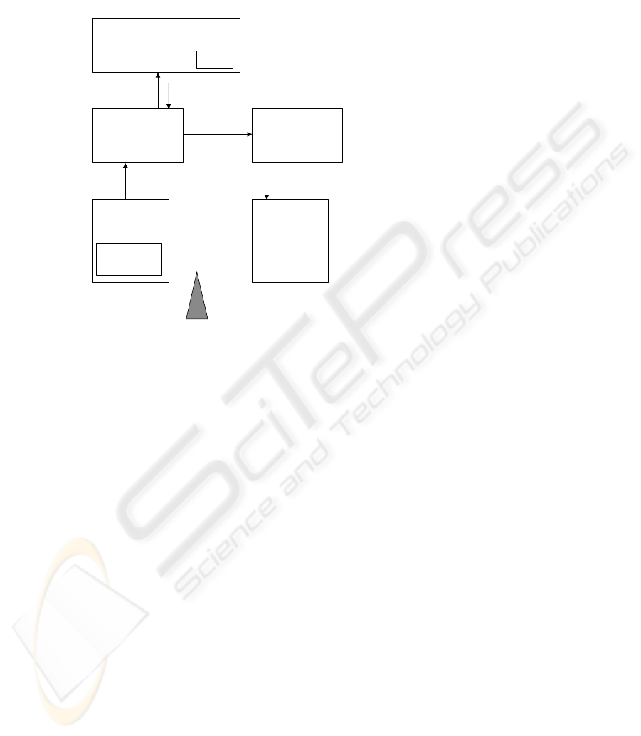
Positioning
unit
S
A
Location Operation
Server
(x,y)
A
Client A
(x,y)
A
S
A
Distribution
Server
telin.nl
(x,y)
A
Distribution
Server
vtt.fi
Client B
(((
Map
Fig. 2. The main entities in a reference architecture that handles location. SA = Signal strength
data for client A. In this example client B is subscribed to (x,y) coordinates of client A.
Fig. 2 illustrates this example. This figure shows how client B, in our case, the
guidance service, requests the position of a client A, the maintenance service person.
These can be two users interested in each others position or, as in our scenario, one
user and an application that is interested in the position of that user. Client B wants to
have this position as an x,y coordinate. However, client A can only provide signal
strengths. So in this example a mapping from signal strength to x,y coordinates take
place. This is a transition from physical level to data level.
Fig. 2 also shows how the flow of information takes place. From this figure one can
see that it is the Distribution Server that is responsible for providing coordinates and
thus it will access the Location Operation Server to convert the information. The
advantage of letting intelligent Distribution Servers communicate with the Location
Operation Servers instead of the client is that the client now only has to communicate
with the Distribution Server for sending physical data. This limits the amount of
wireless communications. Disadvantage of this approach is that the Distribution
Server has to be aware of the context of the client. But probably the Distribution
Server is located close to the client and has access to local maps, service directories
and organisational information related to the user.
23

4 Implementation of a Location Information Handling Service
Two existing positioning technologies, both using different wireless techniques and
both with different ways of determining the actual position of a mobile client have
been used for implementation of part of the proposed solutions. To illustrate our ideas
we started with implementing a generic, i.e. technology independent location handler
interface and a generic location representation format. This section will be concluded
with a description of an exemplary application: the location service.
4.1 The Positioning Technology Independent Location Handler Interface
We have limited our scope by selecting two positioning systems based on WLAN and
Bluetooth technologies respectively to make it easier to implement quick trials to
proof our conceptual framework. In this architecture the positioning hardware itself is
wrapped and hidden from the applications and application developers. Instead the
system provides them a more generic interface to communicate with positioning
technologies to help the design process of the applications and services using
positioning information for their purposes, e.g. tracking or adapting them to user
needs. A well-defined interface layer between hardware and applications provides the
necessary freedom to application engineers to develop location aware services that are
able to use any of different technologies possibly even simultaneously.
4.2 Location Format Compliant to the Mobile Location Protocol
A generic location format at the data level enables the description of location
information at different levels and makes the information useful for different location
aware applications. Main constraint to this format is that it should be technology
independent and that it should be shareable with all possible other applications. For
each level presented in Fig. 1, more parameters are added, but by embedding basic
data in the new enriched format, backwards compatibility should also be sustained.
Finally, a generic location format allows one to match location information to the
different requirements of applications, for example, in terms of accuracy and
granularity. We propose to use the following parameters: (1) Name of the technology
used to obtain this position, (2) Coordinates and a reference to the corresponding
coordinate system, (3) Date and time (to indicate freshness of location) and (4)
Accuracy.
In implementations of our reference architecture a XML based location presentation
language can be used for creating the final location information presentation in the
application layer. In our implementation the presentation form used in carrying the
location information from client to server and further to the subscribers is based on a
subset of the Mobile Location Protocol (MLP 3.0.0), which was defined by the
Location Interoperability Forum (LIF) and is expected to be supported and developed
by the Open Mobile Alliance (OMA, see [12]). It’s structure and parameters make
24
this protocol well suited not only for describing location but also for querying it.
Another important advantage is its extensibility, simple format and readability.
4.3 Implementation of the Positioning Technology Independent Location
Service.
In both positioning technology cases the location information is stored in a PLIM
(Presence and Location Instant Messaging) server. The PLIM server is a slightly
modified version from the original Instant Messaging (IM) [6] server where just the
presence information was available for clients to subscribe to. In the current modified
PLIM architecture the location information is updated and subscribed as the presence
information in basic IM platform. The PLIM server stores the location (XML based)
presentations in its database and provides them to clients. All the PLIM clients log
into one of the PLIM servers and provide their location information (if capable) to the
server where it is stored in the form of a Mobile Location Protocol (MLP)
presentation. Then other clients are able to access this information if their permissions
are set to allow browsing of location information. The PLIM server is administrating
these user restrictions. In other words, we have used PLIM as a Distribution Server.
Using a publish-subscribe mechanism in the Distribution Server, each interested
entity receives information that is in a format that is suitable for carrying out its own
task. For example, one client might only be interested which room a user is in, while a
tracking application might want to have building coordinates. Nevertheless, they can
subscribe to different sets of location information that is related to the same physical
position of that particular user.
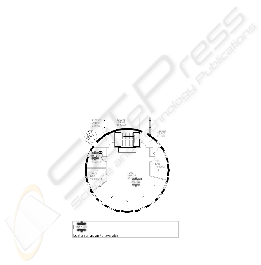
Fig. 3. Map of a large meeting room showing the position of two users equipped with PDAs.
To determine and provide their position, one user is using WLAN technology (WiFi) and the
other is using Bluetooth technology
25

Then we used the positions of two clients and showed them on a map. This map is a
client of the Distribution Server and receives updates of two users, one using the
Bluetooth positioning technology and one using the WLAN positioning technology.
The complete concept of the map application is presented in Fig. 3.
Depending on the hardware the client software picks the right positioning method and
executes the initialization process accordingly. The technology specific location
handler launches a location update process to acquire the latest position of the device
and delivers it to the Distribution Server that can forward this information to other
clients or entities. Distribution of the location information to other users makes it
possible to see each other on the same map. Distribution to other interested
applications makes it possible to reuse the position in other applications, for example
an Instant Messaging application that wants to know if a user is in his office and thus
available for a chat session.
In the case of WLAN positioning the update process is measuring the signal strength
values from the base stations and delivering them to the location server for
calculations of the location. The location server could also act as an information
source for multiple intelligent services, e.g. tracking or distance calculation services
but the only function currently implemented is a basic service providing xy-
coordinates from signal strengths.
When Bluetooth access points are used, the position is acquired directly from the BT
access points. The client device determines its position (a room) based on the
strongest signal it receives from one of the access points. This means that the access
point functions both as positioning unit and Location Operation Server, because it
maps to a physical location.
Note that this application is now able to use two different technologies to position the
user. This has been made possible because the terminal has a generic interface and
because the application uses the same location format and both technologies share the
same coordinate system, i.e. the same map of the room.
5 Conclusions
A generic framework has been proposed that handles simultaneously the
heterogeneity of both positioning technologies and location representations. The main
characteristic of the framework is a strong functional separation of functionality for
distributing and for processing location information. Location Operation Servers have
been defined to do operations to add information to a location information object
enriching it and bringing it to a higher more meaningful level (from physical level to
data and semantic level). We defined Distribution Servers based on a
publish/subscription mechanism to deal with exchanging location information
between different users or entities. This means that the intelligence that is required for
location handling is not in the Distribution Server nor in the client device, but in
specialized functional components, i.e. the Location Operation Servers.
26

Our implementation of a location service proved that our context model and reference
architecture are a good basis for building a system that can deal with heterogeneity of
location information. In this case an application was build that made use of two totally
different positioning technologies.
6 References
1. Hightower, Jeffrey and Boriello Gaetano (2001). Location systems for
ubiquitouscomputing. In IEEE Computer, August, pp. 57-66.
2. Chen, G. and Kotz, D. (2000). A survey of Context-Aware Mobile Computing Research.
Darthmouth Computer Science Technical Report TR2000-381.
3. Beigl, M. Gray, P. and Salber, D. (2001). Location modeling of ubiquitous computing.
Workshop proceedings Ubicomp 2001, Atlanta – September 30, 2001
4. A. Schmidt and K. A. Aidoo and A. Takaluoma and U. Tuomela and K. Van Laerhoven
and W. Van de Velde (1999). Advanced Interaction in Context. LNCS 7007, p.89
5. Dey A. Understanding and Using Context, Personal and Ubiquitous Computing (2001) 5:4-
7.
6. Peddemors, A., Lankhorst, M. & De Heer, J., Presence, location and instant messaging in a
context-aware application framework. 4th International Conference on Mobile Data
Management (MDM2003), 21-24 January, 2003, Melbourne, Australia
7. VTT Electronics, Indoor Navigation Using WLAN 802.11 Positioning, Retrieved March
2003 from http://www.6winit.org/presentations/ist/vtt_6winit.pdf
8. Bahl, P., Padmanabhan, V.N., "RADAR: An In-Building RF-Based User Location and
Tracking System," Proc, IEEE Infocom 2000, Tel Aviv, Israel, March 2000.
9. Ailisto, H., Alahuhta, P., Haataja, V., Kyllönen, V. and Lindholm, M. (2002). Structuring
Context Aware Applications: Five-Layer Model and Example Case, Position Paper, VTT
Electronics, Oulu, Finland. Presented at “Models and concepts for ubiquitous computing”,
workshop at UbiComp 2002, Göteborg, 2002.
10. Svetlana Domnitcheva (2001). Location Modeling: State of the Art and Challenges.
Location modeling of ubiquitous computing. Workshop proceedings Ubicomp 2001,
Atlanta – September 30, 2001
11. Ying Chen, Fangyan Rao, Xiulan Yu, Dong Liu, CAMEL: A Moving Object Database
Approach for Intelligent Location Aware Services. 4th International Conference on Mobile
Data Management (MDM2003), 21-24 January, 2003, Melbourne, Australia
12. Open Mobile Alliance. http://www.openmobilealliance.org/
27
