
ONTHEWAY: A PREDICTION SYSTEM FOR SPATIAL
LOCATIONS
Juan Antonio Álvarez
1
, Juan Antonio Ortega
1
1
Departamento de Lenguajes y Sistemas Informáticos,University of Seville, Av. Reina Mercedes s/n. 41012 Sevilla, Spain.
Luis González
2
, Francisco Velasco
2
, Francisco Javier Cuberos
3
2
Departamento de Economía Aplicada I, University of Seville. Ramón y Cajal 1. 41018 Sevilla, Spain.
3
Departamento de Planificación. Radio Televisión de Andalucía. José Gálvez s/n. 41092 Sevilla, Spain
Keywords: Ubiquitous Computing, context-awareness, location-enhanced.
Abstract: In ubiquitous computing we need to know the present context in order to interact properly with the nearby
smart elements. When we are moving outdoors, mobile devices take a very important role because they
provide us with a link between the world outside and ourselves through means of intelligent interfaces.
There are a lot of situations in which it would be very useful to know or foresee the future context, i.e. as a
geographic environment, where we could find ourselves in a near future, and at the same time being able to
use that information from our devices. Therefore we must preview this location with enough precision and
time and be able to use this information from our mobile device. In our “OnTheWay” system, we used GPS
technology and databases made of past paths taken by a person, in order to predict the next location, once
we had begun a new course, comparing the new one with those ones stored. The results were amazing: from
the data collected about paths travelled during a month and five days, we got the actual destination in 98%
of cases, when we have only made a 30,35% of the total path. Therefore, including statistic and semantic
information will allow us to upgrade our results, due to the sedentary human behaviour, the small number of
frequently visited locations and the fact that the paths used to arrive to these locations are usually the same.
1 INTRODUCTION
The information provided by indoor or outdoors
positioning systems is very valuable; however it is
not fully exploited. The most spread applications
only provide accurate positioning in time and space
of the object or person we would like to locate on
earth. Some programs offer geocoded services that
allow looking for buildings, roads or even taxis.
Nowadays, research works are oriented towards
technical aspects, like the improvement of features
of performance (i.e. acquisition times, positioning
accuracy) or the reduction of energy consumed by
receptors. The Federal Communication Committee
and the European recommendation E112 have made
these researches to grow a lot allowing the wireless
providers to locate accurately within a dozens of
meters, users who make emergency calls
E911/E112. However the applications using this
information are in an early stage of development.
Obtaining semantic information from wild life is
being used incipiently with new applications, as in
some works about tracking animals’ lives, but there
are several problems, like privacy or intimacy when
research is focused on human life. However, these
difficulties should be a technical challenge and not a
handicap. Novel ideas must be planned and the use
of positioning should become an instrument, not a
problem.
This article explains our efforts to predict the
future location of people. The work is based on their
routine activities. We can realise that the principle of
locality or locality of reference in computer science
is valid for the human behaviour. In the most
developed societies, life is lived in a sedentary and
comfort ambient with moves that follow a pattern.
Displacements are usually done to known places like
298
Antonio
´
Alvarez J., Antonio Ortega J., Gonz
´
alez L., Velasco F. and Javier Cuberos F. (2006).
ONTHEWAY: A PREDICTION SYSTEM FOR SPATIAL LOCATIONS.
In Proceedings of the International Conference on Wireless Information Networks and Systems, pages 298-303
Copyright
c
SciTePress

our house, work office, the house of our family,
favourite cinema or the fashionable shopping centre.
These facts are repeated periodically and to get to
our final destination we use different means of
transport. The autonomous recognition of the
destinies we go to, without the interaction of people,
will open our minds to new applications with which
we will know the present context and the future
context.
The known places and the ritual behaviour will
be considered facts and our work will focus on
frequently taken paths. The OnTheWay system will
obtain an accurate and will foretell or foresee the
place where we are going, knowing several points
frequently visited and using the history of the paths
taken by a person.
Possible scenarios and current work about
localisation and mobile data management are
explained in the next sections. In the development
point we will describe the methodology used, called
OnTheWay, the problems reported and the solutions
created to avoid them. Once analysed the features of
the system and the obtained results, we will illustrate
the future context with some scenarios. Finally,
conclusions and future work will be explained.
2 POSSIBLE SCENARIOS
To illustrate the power of OnTheWay system,
possible scenarios will be shown where the
prediction of destinations is helpful.
Tourist information: Saving the frequent
tourist’s journeys, the optimisation of new visits
could be possible: Information about the best path,
the fastest transport to use or the timetable of
museums where the tourist wants to go could be
notified when the destination has been predicted.
Providing the same help to civil service could be
helpful for citizens.
Future interest zones: Predicting that our
destination is the place C, our system could track the
buildings associated to our to-do-list. It could give
us notice of the routes to reach marketplaces,
chemist’s or civil service buildings before going to
C.
Prediction of traffic jams: If the probable
destination of a set of motorists is actually the same
and their paths pass by the same point, then
calculating the number of cars that can pass in an
hour, the OnTheWay system applied to all the GPS
of these cars could obtain a prediction of traffic jams
and notice the drivers other possible paths to avoid
them.
Meetings prediction: A knowledge network
could provide the share of information of relatives or
friends tracking routes. Analyzing this information
the probable places where some of the members of
the community could meet will be possible.
Management of alerts: The possibility to track
person movements can be very useful (e.g. in the
case of Alzheimer or Schizophrenic) when someone
gets lost in an external environment. It is possible to
track and compare usual routes with current ones
and decide to send an alarm before the situation
might put the person in risky situations.
3 RELATED WORK
Research about enhanced localisation is until now
focused to identify frequently visited places. In
(Ashbrook and Starner, 2003), (Hightower, 2005),
(Kang, 2004) and (Marmasse, 2000) authors
describe methods based in different technologies
(GPS, GSM, WiFi) to obtain algorithms that
recognise a reached place during the second and
successive arrivals. The object of these works is to
make easy the use of context in ubiquitous
computing. If we know where we are and what
smart devices surround us, we could interact with
the environment.
The prediction of possible destinations is made
when the person begins a new journey. Moreover the
possibility to foretell in advance and accurately the
places he goes are in-depth approached.
In our research we have assumed the work of
detecting the frequently visited places labelling them
in a map through its coordinates and a textual
representation of the place like we know it, i.e. we
are familiar with the term “home”, but we don’t
know that it corresponds to the coordinates
37°22'55.98"N, 5°58'14.20"W.
On the other hand, when tracking wild animal
life projects like (POST project, 2002), (Pei Zhang,
2004), (VAFALCONS, 2002) and (Puma Project,
2004) positioning technology to store the journeys
and extract information about animal behaviour is
used. Concretely in ZebraNet project (Pei Zhang,
2004), unknown information until now has been
obtained. Biologists know now that zebras explore
more wooded areas and gullies at night.
Although it is not intended to track human life, it
is obvious that their way of moving allow the
creation of interesting and useful applications which
could manage future situations obtained from
predicted contexts.
ONTHEWAY: A PREDICTION SYSTEM FOR SPATIAL LOCATIONS
299

Another important issue in this kind of
applications is the mobile data management. In
(Waluyo 2005), (Kayan, Ulusoy, 1999) and (Perich
2004), location-dependent information services,
real-time data access requirements and new data
management challenges are analysed.
4 DEVELOPMENT
Firstly, scope and used terms will be defined; next
the used methodology there will be described.
4.1 Scope of the Problem
OnTheWay proposal is based on the similarity of
journeys to foretell the place where we are going
when we begin a new path. This problem depends
on the spatial dimension of the course so temporal
dimension will be put away because it will increase
the difficulty of our problem (e.g. a journey by car
compared temporally to the same path by bicycle
will be temporally very different). Elected option for
avoid this, was a sampling used to acquire the spatial
data with a temporal frequency of one second. On
this way, graphical representation will be simplified
too from three to two dimensions (longitude and
latitude).
4.2 Terms Definition
Concepts will be simplified on defining the next
terms:
Point: Tuple composed by their geographical
values of longitude and latitude.
p=(long, lat)
Place: Tuple composed by a point and a radius.
Both define a circumference centred on the origin of
the place. The third element is a label representing
the semantic information about this place (“home”,
“work”, etc.)
L=(p, radius, label)
Current path or current journey: Set of points
obtained sampling the geographic coordinates using
the positioning system. In our case was GPS (Global
Positioning System). These points are validated by
this system, satisfying the correct number of
satellites that allow obtain an accurate position. The
points of the current path are separated by not less
than 30 meters to avoid redundant information. So,
let
X={ p
0,
p
1,
…, p
n
} be the set representing a path.
Figure 1: Generating the scope of a path.
Class: Given a place origin A and another
destination B. A class will be defined as the pair A-
B or B-A. Although the path from A to B will
probably be different, we will suppose the same
class to reduce the number of journeys needed to
train the system.
Labelled path: Given a finished path, it will be
labelled with its class.
X
A-B
=
X|A=(P,radius1,origin)^B=(Q,radius2,destination)
Distance between points: Although in the cities
the distances are considered using the Manhattan
distance, OnTheWay system uses the great-circle
distance based on the spherical geometry and very
important for finding the shortest distance between
points on the surface of the Earth. To express it
between two points it will be notated by d(pi,qj).
Scope of a path: Given a labelled path X
A-B
={
p
0,
p
1,
…, p
n
} and a point q, this point will belong to
the scope of the path if there exists some point of the
path which distance to q is less than a given value of
δ: q ∈ Scope(X
A-B
), if ∃ j | d(p
i
,q)≤ δ.
On our work we have determined that δ=85
meters is an adequate distance to consider. A point
will be on the scope of a path if it belongs to the
region generated on the figure 1.
Canonical path or representative: Given a set
of labelled paths with the same class, we will choose
one of more paths from this set to represent it in an
accurate manner the others. The reliability will be
given by the percentage of points that belongs to the
scope of this path. The more paths from the class are
enclosed by a canonical path, the better
representative is it.
Because there could be different paths used to do
a journey from A to B, more than one canonical will
be accepted to represent each class.
Similarity of paths: A path matches with other
if it has a percentage of points from their total that
belong to the scope of the second one. The similarity
level will be expressed like this:
Given X
A-B
={ p
0,
p
1,
…, p
n
} ^ Y
C-D
={ q
0,
q
1,
…,
q
m
}
Similarity(X
A-B ,
Y
C-D
)=
WINSYS 2006 - INTERNATIONAL CONFERENCE ON WIRELESS INFORMATION NETWORKS AND SYSTEMS
300
100*(Number of qi ∈ Scope(X
A-B
))/m
Hence, given X
A-B
={ p
0,
p
1,
…, p
n
} ^ Y
={ q
0,
q
1,
…, q
m
}
Y will be identical to X
A-B
if ∀i, q
i
∈ Scope(X
A-B
)
and Y is labelled with the class A-B so it is a
labelled path: Y
A-B
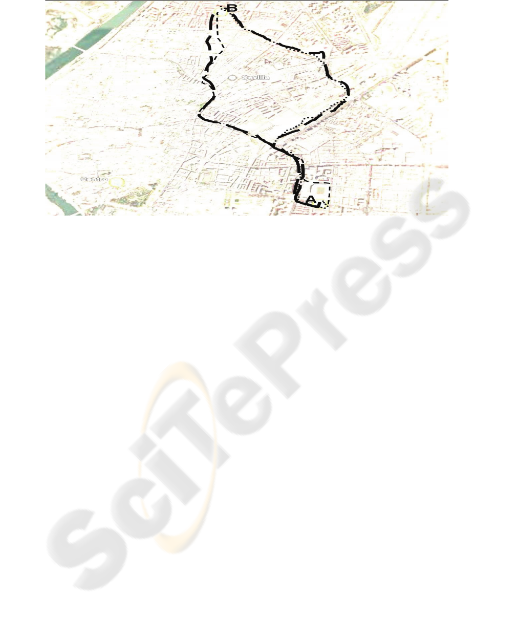
Figure 2 shows an example of four journeys on
Seville, X
1
A-B
,
X
2
A-B
(both on the left of image), X
3
B-
A
and
X
4
A-B
(both on the right).
All of the paths are from the class A-B. Although
the places origin and destination of all are the same,
for a correct tagged, OnTheWay should take two
canonical paths, the first one for represent two on
the right and the other for represent the two on the
left. Section called selection of canonical will
describe the manner to take the canonical paths.
4.3 Methodology
4.3.1 Data Retrieval
Data retrieval was done by the authors during the
period from December 10th, 2005 and January 14th,
2006. The journeys were tracked in the cities of
Sevilla (31 days), Almeria (3 days) and Granada (1
day). Data obtained from Granada was insufficient
to any prediction but the tracked paths on Sevilla
and Almeria were very useful. 103 tracked paths
were obtained. To achieve this set of routes, a
Royaltek Bluetooth GPS was used. Due to the
impossibility of storing these tracked paths on the
device, a Dell Axim X30 PDA was used to store the
routes on NMEA format.
The vehicles used were only bicycles and cars.
4.3.2 Labelled
When the destination was reached, the NMEA file
was renamed including the date and time of the
journey, the origin and the destination. Moreover,
the file was transformed to KML format, used by the
GoogleEarth software to obtain an easy and fast
representation. On the conversion, unreliable or
erroneous points were filtered.
4.3.3 Data Cleaning and Bizarre Paths
Two kinds of problems were distinguished on the
Data retrieval process: some derived from the GPS
technology and others derived from the real
experience.
GPS technology:
• First valid GPS point: The validation system of
GPS takes some time to obtain the first correct
point. If the receiver is still, the duration is
about 1 minute. If the receiver is in movement
the duration could be much more. On the
collection of data, the first valid point
sometimes was very far on space and time from
the real origin of the journey. Despite this, the
path was tagged with the real origin (not the
first validated) and destination. These paths
would not be a canonical path because the
canonical ones must represent with fidelity the
real path. So, we need a rule to select it
checking that initial and finals points are close
to the real places of origin and destination.
• “Urban canyon” effect: The global positioning
satellite signal cannot be received by the
Figure 2: Four paths from A to B.
ONTHEWAY: A PREDICTION SYSTEM FOR SPATIAL LOCATIONS
301

receiver if it is surrounded by tall buildings or
hills. It causes interruptions of validated
positions during a variable time. So it reduces
the number of correct points on the track file.
Although the cities where the Data retrieval did
not have skyscrapers or lots of tunnels, the
effect was observed on narrow roads. Because
of this, we add a new rule to discriminate
canonical paths from non canonical ones: Each
couple of points composed by one point and the
next one, have to be near. If the distance
between them is more than the advanced in a
car the points will not be close. Data sampling
interval is 1 second in our Royaltek GPS and it
was considered the possibility of having one
point not validated between two NMEA
validated, so due to the speed limit is 120 k.p.h.
in most countries, the distance considered was
66,7 meters.
Real experience:
• In Data retrieval and the labelling process,
problematic situations that could alter the
selection of canonical paths were found. The
main problem occurred when it was difficult to
find a place to park the car during a journey.
That caused the driver to become stressed-out
and the increase of points collected on the
surroundings of the destination place. The
selection of this kind of journeys and their
associated paths as canonical paths would be an
error because another path would not be similar
to this one even if their origins and destinations
were the same. So we add another rule that
specifies that if there are two paths that satisfy
the last two rules, we will take the one that has
fewer points.
After having verified the tagged paths, 7 were
discarded because their results were totally
erroneous or nonsense. So it rested 96 with checked
information including the ones that had the features
explained.
4.3.4 Canonical Paths Selection
Given a set of labelled paths from the place
origin=(o, r1,A) to the place destination=(d,r2,B),
X
0
A-B
X
1
A-B ...
X
n
A-B
the selection of a canonical path
X
c
A-B
={ p
0,
p
1,
…, p
m
} | 0 ≤ c ≤ n will be done
following the next rules:
• Rule 1. Nearby to origin and destination:
∀ i ∈ [0,k], dist(p
i,
o) ≤ r1 ^ ∀ i ∈ [m-k,m],
dist(p
i,
d) ≤ r2
• Rule 2. Uniform distribution:
∀ i ∈ [0,n), dist(p
i,
p
i+1
) ≤ 66,7 meters.
• Rule 3. Less number of points:
If X
i
A-B
X
j
A-B
satisfy the rules 1 and 2 and
similarity(X
i
A-B
X
j
A-B
)>80, then it would be selected
the one with less points.
• Rule 4. More than one canonical:
If X
c
A-B
is a canonical path and we found another
path X
i
A-B
| similarity(X
c
A-B
X
i
A-B
)<80, then we will
consider X
i
A-B
also as a representative.
After applying this rules to the learning set of
paths, we obtained 44 canonical paths and 52 non
canonical.
4.3.5 Off-line Results
Once the set of canonical paths were obtained,
legitimacy of the methodology was checked
comparing the sets of representative and non-
canonical paths. The goal was to predict the
destination where the non-canonical path went to. So
for a non-canonical path, his similarity index was
obtained for all the canonicals, and the one that
produces the greater index was selected. We
compare the destination from the selected canonical
path with the real destination of the non-canonical
path. The results were correct in 51 of 52 cases. The
incorrect case was because a canonical path was not
selected when it should. These results showed us the
strength of the methodology and the importance of
the selection of the canonical paths. Due to the good
results obtained in the off-line mode, we faced the
task of obtaining the point where the correct
prediction begins.
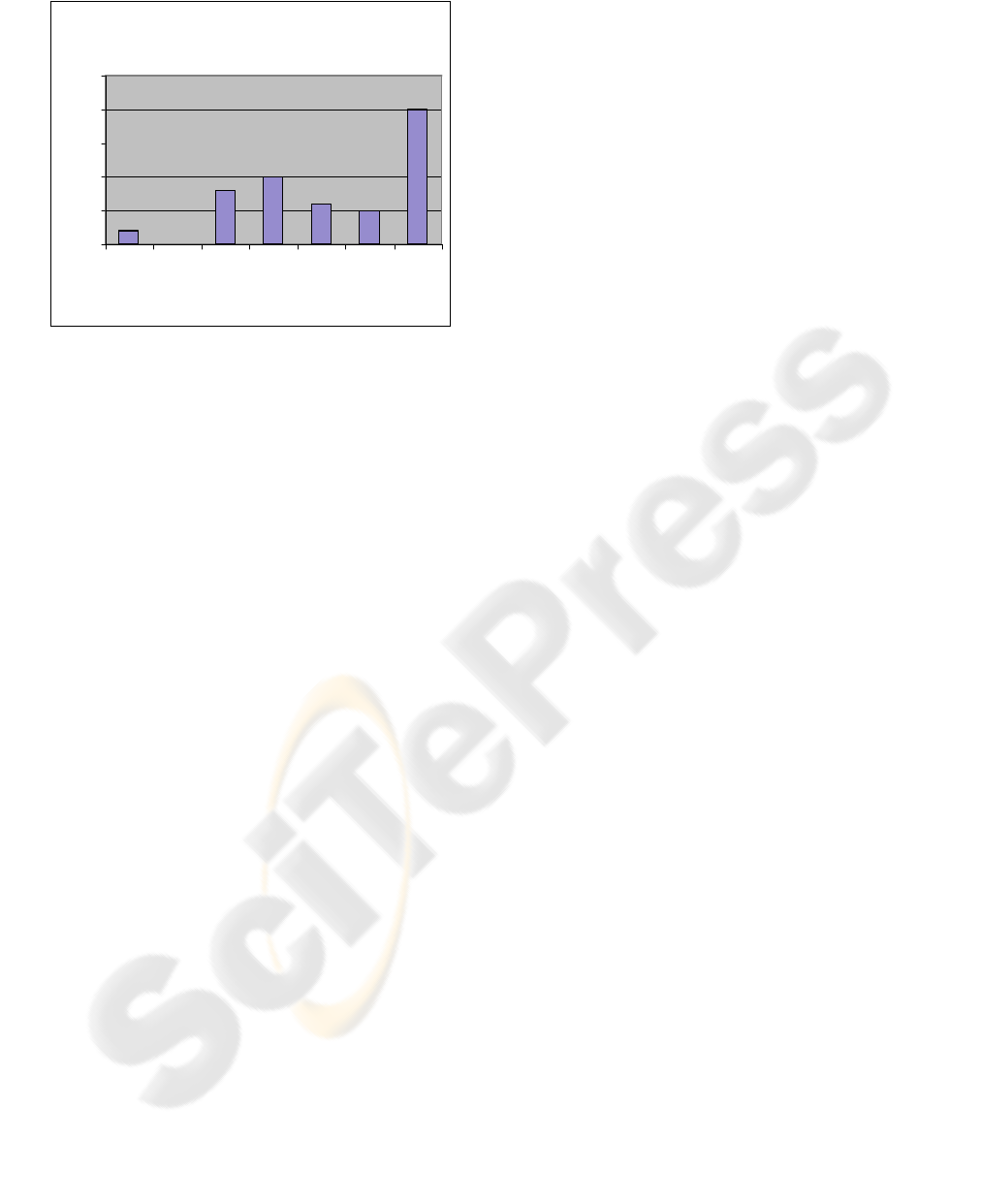
4.3.6 On-line Results
Having checked the similarity index with all the
canonicals over all the points of the non-canonical
path, the predicted destination in each point was
obtained. The point when the real destination was
predicted not being altered until the end of the path,
was called detection point. Results were coherent
with common sense: Until the itinerary did not enter
in a not common area with other paths, it was
impossible to distinguish where we go. Nonetheless,
we also observed that although there were overstrike
paths, often small changes taken on the paths
allowed the OnTheWay system to distinguish the
correct destination. The results were very hopeful
because the remaining distance to the destination
measured in a straight line, on average was the
69,65% of the total path and the remaining time to
reach the destination was more than the 70% of the
total (when the journey finally stops). It was
considered that a new detection point that remained
stable for some meters, could be defined as a
decision point. The spatial pertinent value seemed to
WINSYS 2006 - INTERNATIONAL CONFERENCE ON WIRELESS INFORMATION NETWORKS AND SYSTEMS
302
be 120 meters. This value adds these amount of time
and space to the decision point, being specially
harmful for the paths in which the decision arrived
very late, as it causes the arrival to the destination
comes before we can predict it. However, the
capacity to predict future context is real and very
helpful.
5 CONCLUSION AND FUTURE
WORK
This work opens a new research line on the
enhanced localization systems, founded on the
ritually behaviour of people. Although the habits of
movements of people are not the same, knowing
some of the last and past routes, we can intuit the
future paths. This paper exploits this intuition to
show in a concrete experience, how to predict in
advance the places where we will go in a nearby
future.
The exercise of tracking the set of journeys
which will be the canonical paths suppose that the
efficiency of the methodology followed in
OnTheWay will be better with more tracked
journeys, but it will include some obstacles as the
close places or the overstrike paths that difficult the
prediction and produce the detection of decision
points very close to the final destination. To avoid
these disadvantages, we are planning to include
semantic information and statistic models to our
system. It will permit to distinguish the most
probable place between some of them using the
spatial, temporal, semantic and statistical
information of the user. We are including also the
diary book to obtain the semantic data.
Short paths done in home and indoor buildings
will be researched to use as base for handicapped
persons who moves slowly or in a wheelchair. In
this way, we will pass to technologies used in
indoor: RFID or Bluetooth. Finally, connection
between indoor and outdoor positioning systems will
be studied for a better use the future context.
Concretely, in (Shun-Yuan, 2005) is shown a novel
system to locate persons in indoor and outdoor
environments founded on the relative position of
shoes when someone walks.
REFERENCES
Ashbrook, D. and Starner, T. Using gps to learn
significant locations and predict movement across
multiple users. Personal Ubiquitous Computing,
(7):275–286, 2003.
Census of Marine Life. (Oct. 2002) POST: Pacific Ocean
Salmon Tracking Project. http://www.postcoml.org/,
2003. (ASPLOS-X).
Hightower, J. et Al. (Sep. 2005) Learning and
Recognizing the Places We Go, In Proceedings of the
Seventh International Conference on Ubiquitous
Computing (Ubicomp 2005), pp. 159-176.
Kang, J.H., Welbourne, W., Stewart, B., Borriello, G.
(2004): Extracting places from traces of locations. In
Proceedings of the Second ACM International
Workshop on Wireless Mobile Applications and
Services on WLAN Hotspots (WMASH 2004),
Philadelphia, PA, ACM Press 110–118
Kayan E, Ulusoy O. (1999) An evaluation of real-time
transaction management issues in mobile database
systems. Computer Journal 42 (6): 501-510
Marmasse, N., Schmandt, C. (2000) Location-aware
information delivery with commotion. In Proceedings
of the Second International Symposium on Handheld
and Ubiquitous Computing (HUC). Volume 1927.,
Springer-Verlag 151–171
Pei Zhang et Al., (2004) Hardware Design Experiences in
ZebraNet. Department of Electrical Engineering
Princeton University, Sensys 2004
Perich F et Al, (2004) On data management in pervasive
computing environments. IEEE Transactions on
Knowledge and Data Engineering 16 (5): 621-634
May 2004
Shun-Yuan Yeh et Al. (2005) Geta sandals: knowing
where you walk to. Ubicomp 2005
The Center for Conservation Biology.
(2002)VAFALCONS. http://ccb-
wm.org/vafalcons/falconhome.cfm
UC Davis Wildlife Health Center. Southern California
(2004) Puma Project.
http://www.vetmed.ucdavis.edu/whc/
Waluyo AB et Al. (2005) Research on location-dependent
queries in mobile databases. Computer Systems
Science and Engineering 20 (2): 79-95 Mar 2005
Figure 3: On-line results.
Destination detection
0
5
10
15
20
25
(1,10] (10,20] (20,40] (40,60] (60,80] (80,90] (90,100]
% of remaining distance
Num ber of paths
ONTHEWAY: A PREDICTION SYSTEM FOR SPATIAL LOCATIONS
303
