
USING GAZETTEERS TO ANNOTATE GEOGRAPHIC
CATALOG ENTRIES
Daniela F. Brauner, Marco A. Casanova, Karin K. Breitman, Luiz André P. Leme
Informatics Department, PUC-Rio, Rua Marquês de S. Vicente, 225, Rio de Janeiro – RJ, Brazil
Keywords: Gazetteer, Geographic Metadata Catalog, GIS Integration, Thesauri Alignment.
Abstract: A gazetteer is a geographical dictionary containing a list of geographic names, together with their
geographic locations and other descriptive information. A geographic metadata catalog holds metadata
describing geographic information resources, stored in a wide variety of sources, ranging from the
researchers’ personal computers to large public databases. This paper argues that unique characteristics of
geographic objects can be explored to address the problem of automating the generation of metadata for
geographic information resources. The paper considers federations of gazetteers and geographic metadata
catalogs and discusses in detail two problems, namely, how to use gazetteers to automate the description of
geographic information resources and how to align thesauri used by gazetteers. The paper also argues why
such problems are important in the context of a federated architecture.
1 INTRODUCTION
Scientific data are housed in a wide variety of
resources, ranging from the researchers’ personal
computers to highly organized repositories
maintained by organizations. To help users locate
and access the available data, a common solution is
based on metadata catalogs. Among the metadata
stored in catalogs, one typically finds a classification
scheme for the data, defined as a structured
collection of terms, that is, as a thesaurus.
However, the process of manually generating
metadata can be tedious, if not impossible,
depending on the amount of new data generated.
Therefore, a catalog should be equipped with a
component that automates metadata generation as
much as possible. Such component may derive
metadata from the characteristics of the data
acquisition platform, from a (quick) analysis of the
data content and from related data and metadata
stored in the catalog itself or elsewhere.
Frequently, metadata catalogs are not isolated,
but they form a federated system. In this case, a
second problem arises, namely, the question of
aligning different classification schemes. This
problem also requires semi-automated solutions to
make the catalog federations viable.
In the geographic information systems domain,
we find two valuable ways to address these
problems. First, we have various geo-referencing
schemes that associate each geographic object with a
description of its position on the Earth’s surface,
which acts as a universal identifier for the object, or
at least an approximation thereof. Second, many
gazetteers, or dictionaries of geographic names, have
been developed in recent years and made available
on the Web.
Based on these preliminary observations, we first
propose an architecture that takes advantage of
gazetteers to automatically generate meaningful
metadata for geographic information resources.
However, we also argue that gazetteers will have to
be expanded to include information about scale, and
catalog metadata schemes will have to be carefully
designed to facilitate integration with gazetteers.
Next, we consider federations of gazetteers and
geographic metadata catalogs. In this context, we
argue that gazetteer thesauri alignment is the central
problem, which we propose to solve by introducing
a technique that takes advantage of geo-referencing
to avoid the pitfalls of aligning the thesauri terms
based solely on syntactical proximity.
As for related work, Fu et al. (2003) and Souza et
al. (2005), for example, use gazetteers to help index
Web resources in general. Klien and Lutz (2005)
propose a method for automating the annotation
process based on spatial relations.
Our approach uses the gazetteers to describe
geographic information resources. As argued in
Section 3, we do not limit ourselves to checking the
215
F. Brauner D., A. Casanova M., K. Breitman K. and André P. Leme L. (2006).
USING GAZETTEERS TO ANNOTATE GEOGRAPHIC CATALOG ENTRIES.
In Proceedings of the Eighth International Conference on Enterprise Information Systems - DISI, pages 215-220
DOI: 10.5220/0002459902150220
Copyright
c
SciTePress

occurrence of geographic names in the data to be
indexed or described, but use geo-referencing to
relate gazetteer entries and the data to be catalogued.
We also use geo-referencing to address the problem
of gazetteer thesauri alignment, as discussed in
Section 4.
This paper is organized as follows. Section 2
summarizes the major characteristics of gazetteers
and geographic metadata catalogs. Section 3
discusses how to generate meaningful metadata from
gazetteer entries. Section 4 expands the discussion to
federations of gazetteers and geographic metadata
catalogs. In special, it discusses how to consolidate
thesauri from different gazetteers. Finally, Section 5
contains the conclusions.
2 GAZETTEERS AND
CATALOGS
This section briefly summarizes basic concepts
pertaining to gazetteers and geographic metadata
catalogs, and lists additional references to related
work.
A feature is an abstraction of a real world
phenomenon and a geographic feature is a feature
associated with a location relative to the Earth. In
the familiar Computer Science jargon, a
(geographic) feature is an object with a special
attribute that describes the object’s location on the
Earth surface, using a given coordinate
(geo)reference system (CRS).
A gazetteer is a list of geographic names,
together with their geographic locations and other
descriptive information. A geographic name is a
proper name for a geographic place or feature, such
as the City of Rio de Janeiro. We are interested in
gazetteers that are available over the Web, such as
the GNS and the ADL Gazetteer.
The GEOnet Names Server (GNS) (GNIS, 2005)
provides access to the National Geospatial-
Intelligence Agency (NGA) and the U.S. BGN
database of foreign geographic names, containing
about 4 million features with 5.5 million names.
The ADL Gazetteer (Hill et al., 1999) has
approximately 5.9 million geographic entries
classified according to the ADL Feature Type
Thesaurus (FTT), a classification scheme that
combines the vocabularies of the GNIS and the
GNPS. Indeed, gazetteers often organize feature
types as a thesaurus, which we will generically call a
feature type thesaurus, by analogy with the ADL
FTT.
A thesaurus (ISO-2788, 1986) is “the vocabulary
of a controlled indexing language, formally
organized so that a priori relationships between
concepts (for example as "broader" and "narrower")
are made explicit.” A thesaurus usually provides: a
preferred term, defined as the term used consistently
to represent a given concept; a non-preferred term,
defined as the synonym or quasi-synonym of a
preferred term; relationships between the terms, such
as narrower term, indicating that a term T – the
narrower term – refers to a concept which has a
more specific meaning than another term U – the
broader term.
An information resource is a (logical) entity that
can be managed by a catalog service (Senkler et al.,
2004). We will be particularly interested in
geographic datasets in what follows. We will assume
that geographic datasets will have at least a scale and
a description of the area of the Earth’s surface that
the dataset covers. This description is often a
rectangle or a parallelogram, whose vertices are
defined by coordinates in a given coordinate
reference system (CRS). The scale, the description
of the area covered and the CRS used are treated as
metadata of the dataset.
Several standards for metadata appear in the
literature. The Content Standard for Digital
Geospatial Metadata (CSDGM) is mandatory since
1994 for all geographical datasets in the US (FGDC,
2002). The CSDGM and European initiatives have
been unified as the ISO 19115 metadata standard
(ISO-19115, 2002).
A metadata catalog holds metadata describing
information resources stored in data sources (Nebert,
2002). A catalog offers services to query and
manage metadata, as well brokering services to
retrieve resources, which is relayed to the data
sources. Typically, a catalog does not store or
manage the information resources themselves.
The OpenGIS Catalog Services (OCS) (Nebert,
2002) specification defines a collection of services,
a minimal query language, and a core metadata
schema, based on the ISO19115 - Geographic
Information Metadata. The specification includes
services to update the catalog, invoked by an
application or by the catalog itself.
3 CENTRALIZED
ARCHITECTURE
We first consider a centralized architecture that
combines a single gazetteer and a single geographic
metadata catalog. We show how to use the gazetteer
thesaurus to classify geographic datasets and how to
use gazetteer entries to describe geographic datasets.
The Centralized Enhanced Metadata Catalog
has two major components. The Catalog Manager
provides query and management services to
ICEIS 2006 - DATABASES AND INFORMATION SYSTEMS INTEGRATION
216

maintain a Metadata Catalog, describing
information resources, and a set of relationships
between catalog and gazetteer entries. The Gazetteer
Manager provides query and management services
to maintain a Gazetteer, describing geographic
features, and a Gazetteer Thesaurus, with
classification terms for geographic features.
Let GA be the gazetteer and assume that each
entry E in GA, representing a geographic feature F,
has a geo-referenced representation geo(E) of (an
approximation of) the location of F, and a type(E)
for E, whose value is a term taken out of a thesaurus
T[GA].
Let MC be a geographic metadata catalog and
assume that each entry C in MC, representing a
geographic dataset R, has a geo-referenced
representation geo(C) of (an approximation of) the
area (on the Earth’s surface) that R covers, a
description scale(C) of the scale of geo(C). We
argue that:
Q1. T[GA] can be extended to also provide a
classification for catalog entries, that is, to provide a
feature type type(C) for C.
Q2. A description desc(C) for C can be
generated by relating C to gazetteer entries in
relevant ways.
Intuitively, assuming that a geographic dataset R
covers an area of the Earth’s surface, we may
describe R by the collection of features that occur in
the area. However, we filter out features whose type
is inconsistent with the intended interpretation of R
or whose extent is smaller than the scale of R. In the
latter case, the type of the feature should give
sufficient indication if the feature is compatible with
the scale of R
.
For example, let R be a dataset. If R should be
interpreted as a political map, then R should
represent cities and the political division of a given
area. Depending on the scale of the map, only cities
above a certain population should in fact be
included. If R should be interpreted as a
hydrographical map, we maintain rivers and creeks,
but suppress cities. Moreover, if the map has a large
scale, we maintain only rivers, and also suppress
creeks. As a third example, if R is a satellite image
of a given area, then R potentially represents all
features occurring in the area. However, features
whose extent is smaller than the resolution of R
should be filtered out.
In general, we first suggest: (i) to classify
geographic datasets also using T[GA]; (ii) to
indicate the scale that is compatible with each term
in T[GA].
This is formalized as a function s: T[GA]→R
*
that maps each term of T[GA] into a non-negative
real number. For each t∈T[GA], if s(t)>0, we
interpret s(t)=n as indicating that all features of type
t are compatible with a scale 1:n, or smaller (in the
sense that they can be represented in that scale). If
s(t)=0, we interpret s(t) as indicating that t can be
used to classify geographic datasets.
As an example, consider the fragment of the
ADL Feature Type Thesaurus shown in Figure 1(a),
at the end of the paper. For example, we may then
define:
s(“creek”)=10,000 to indicate that features of
type “creek” should only be represented in a scale
1:10,000, or smaller;
s(“hydrographic features”)=0 to indicate that
the term “hydrographic features” can be used to
classify geographic datasets.
In certain situations, the function s:
T[GA]→R
*
may be partly computed from other
attributes of the gazetteer thesaurus terms. For
example, if each term t under “streams” has an
attribute w indicating the width of the streams that
are classified as t, then the value of w for t may be
used to define s(t).
As for question Q2, we first define that a
gazetteer entry E, representing a geographic feature
F, is relevant to a catalog entry C, representing an
information resource R, iff:
geo(E) and geo(C) are related by one of the usual
topological relationships – touch, in, cross, overlap
(Clementine et al., 1993) – as well as others, such as
within;
type(E) is compatible with scale(C).
We then define desc(C) as the set of pairs (E,r)
such that E is relevant to C and geo(E) and geo(C)
are related by the topological relationship r.
Some gazetteers also include the concept of a
famous place, such as a tourist attraction, an
important city, etc. (GNIS, 2005). If the gazetteer
adopted implements this concept, we may expand
the notion of relevance previously defined to include
famous places as a significant piece of information.
For example, consider a satellite image of the City
of Friburgo, which lies northwest of the City of Rio
de Janeiro. Then, instead of just associating the
image with the City of Friburgo, we may also
indicate that the image covers an area northwest of
the City of Rio de Janeiro, a famous place. Note that,
when relating famous places and information
resources, we may adopt directional relationships –
north-of, south-of, east-of and west-of – or
qualitative relationships, such as near.
As an example of how to generate desc(C),
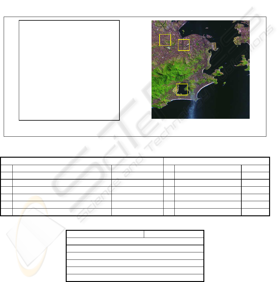
suppose that we adopt the ADL Gazetteer and the
ADL Feature Type Thesaurus. Consider the image
fragment of the City of Rio de Janeiro, taken out of
the Website “Brazil seen from Space” (Embrapa,
2004), shown in Figure 1(b).
This image will be processed as follows:
Extract the georeferencing parameters from the
USING GAZETTEERS TO ANNOTATE GEOGRAPHIC CATALOG ENTRIES
217

information resource. In this case, the image
fragment is consistent with a scale of 1:25,000 and
has a bounding rectangle defined by the pair of
coordinates ((43°15’W, 22° 52’ 30”S), (43° 07’
30”W, 23°S)).
Assume that the user chooses to relate the image
fragment with “hydrographic features”, a term of
the ADL FTT that, in our running example, can be
used to classify geographic datasets.
Since the ADL Gazetteer entries have no
associated scale information, ignore it.
Access the ADL Gazetteer, using the parameters
extracted in Step 1 and the ADL FTT terms under
“hydrographic features”, the term selected in Step
2. The query returns 9 entries, among which the first
3 are:
a. Feature(“Rodrigo de Freitas, Lagoa -
Brazil”, lakes, within)
b. Feature(“Comprido, Rio – Brazil”,
streams, within)
c. Feature(“Maracana, Rio – Brazil,
streams, within)
Store the result of the query as a description of
the information resource, that is, as a list of pairs
(N,r), where N is a geographic feature returned in
Step 4 and r is the topological relationship between
the image and N (in this case, r is “within”).
This brief example illustrates some of the basic
ideas of the paper. First, the use of the gazetteer
thesaurus to also classify geographic datasets
precludes the adoption of a second classification
scheme, such as the ISO19115 Topic Categories
(ISO-19115, 2002). This approach simplifies
mediating access to multiple catalogs and gazetteers,
as discussed in Section 4. However, it requires
defining the compatibility function s:
T[GA]→R
*
.
Second, a useful description of a geographic
information resource R can be created as a list of
pairs (N,r), where N is a geographic feature and r is
the topological relationship between R and N,
obtained by querying the gazetteer. In addition, the
list contains only features whose type is compatible
with the scale of R.
4 FEDERATED ARCHITECTURE
The discussion in Section 3 assumed a single
gazetteer, with a geographic feature type thesaurus,
and a single catalog. However, as pointed out in the
introduction, a federation of gazetteers and
geographic metadata catalogs, supported by
mediator, is a more realistic architecture. Such
mediators will need a tool to align different gazetteer
thesauri that, according to the discussion in Section
3, are used to classify both gazetteer and catalog
entries.
More precisely, let G and H be two gazetteers.
Assume that they classify features using two
thesauri, T and U, respectively. Suppose that we
adopt the schema of G as the mediated schema, but
we allow changing T to accommodate terms in U
that have no counterpart in T .
This means defining a function reclass:U→V that
maps terms in U into terms of a new thesaurus V,
created from T and U. If reclass(t)=u then we say
that t is the reclassification of u. In the rest of this
section, we only analyze two cases of this sub-
problem, for reasons of brevity.
Suppose first that G and H contain entries that
represent disjoint sets of features, and that T and U
represent disjoint sets of concepts. Albeit simple,
this is a common scenario.
We first graft U into T, using a term p of T as
pivot, that is, we add the root u of U as a new narrow
term of a p. This operation creates a new thesaurus,
denoted T[p,U]. Now, when the mediator accesses
entries in H, it will not change their type, that is,
reclass:U→T[p,U] is the identity function.
However, note that the grafting operation requires
user intervention, since there is no failsafe way to
automatically identify p by observing just the terms
in T and U, and their definitions.
For example, let H be the list of real state assets
of a large company, classified according to a
thesaurus U. Assume that the company operates in
Brazil, Venezuela and Argentine. Suppose that G is
a copy of the ADL Gazetteer, restricted to these
three countries. Then, to access the company’s assets
in H, using the ADL Gazetteer schema, we first add
the root of U as a new narrow term of “manmade
features”, a term of the ADL Feature Type
Thesaurus (FTT), on the grounds that the company’s
assets are neither listed in G, nor they can be
classified with the terms found in the ADL FTT. The
result of the alignment process will be a thesaurus
that contains the ADL Feature Type Thesaurus
entries plus the entries in U.
Suppose now that G and H represent non-
disjoint sets of features, and that they have thesauri
that represent non-disjoint sets of concepts. This is a
complex, but not uncommon scenario, which occurs
when the mediator wants to access both G and H.
For brevity, we consider only the case where T,
the thesaurus of G, will remain unchanged, which
means that the range of reclass is T. We discuss how
to use a gazetteer sampling technique that takes
advantage of geo-referencing to avoid the pitfalls of
syntactical alignment.
We first define a relationship Ident ⊆ G×H such
that, for any (E,F)∈G×H, we have that (E,F)∈Ident
iff E and F denote the same (real-world) feature.
ICEIS 2006 - DATABASES AND INFORMATION SYSTEMS INTEGRATION
218

Note that Ident is not total in G or H, since G may
have entries that do not correspond to features
represented in H, and vice-versa.
There are several possibilities to compute Ident
from the attributes of the gazetteers entries. For
example, suppose that both G and H associate each
entry with the centroid of the location of the feature
the entry represents. Then, we may define that
(E,F)∈Ident iff E and F have the same centroid
(after conversation to a common coordinate
reference system), under a given margin of error.
This approach is not failsafe since two different
features may have the same centroid, by
coincidence, or because the scale is not precise
enough. Note that we could have used any other
representation or approximation of the features’
locations, such as bounding boxes, for that matter.
We access both gazetteers to create a partial
alignment relation P ⊆ G×T×H×U such that
(E,t,F,u)∈P iff (E,F)∈Ident and t and u are the types
of E and F, respectively. Note that t is a term of T
and u is a term of U. That is, P contains all pairs of
entries from G and H that denote the same feature,
together with their classifications from T and U.
For each term u∈P[U], the projection of
P onto
U, we define reclass(u)=v iff v∈T is the least
common ancestor of all terms t∈T such that there is
(E,t,F,u)∈P, for some E∈G and F∈H. Intuitively, T
might have a richer classification for the features
that U classifies as u.
Since the reclassification has to be automatic, we
can only choose one term v of T to map u into. We
then choose the least general term that is consistent
with the current entries in G and H. An interesting
degenerated case is when, for any (E,t,F,u)∈P and
(E’,t’,F’,u)∈P, we have t=t’, in which case
reclass(u)=t. Intuitively, as currently observed, G
and H consistently classify entries as u and t,
respectively.
For each term u∈U that does not occur in P[U],
we define reclass(u)=undefined. User intervention is
then required to redefine ident(u), if undefined is
unacceptable.
For example, suppose that G is the ADL
Gazetteer and H is the GEOnet Names Server
(GNIS, 2005) and that we query both gazetteers for
“Rio de Janeiro”. The GEOnet Names Server will
return two entries, representing cities in Colombia,
not represented in the ADL Gazetteer. By contrast,
the ADL Gazetteer will return two entries,
representing streams in Brazil, not represented in the
GEOnet Names Server.
Since both gazetteers return the centroid, we
define (E,F)∈Ident iff E and F have the same
centroid. Based on the data returned on the
definition of Ident, Table 1 shows the partial
alignment relation and Table 2 exhibits the partial
definition of the function reclass.
Based of this fragment of reclass, the mediator
may then access entries in the GEOnet Names
Server classified as “SMTI”, “PPLA”, “PPL”,
“MT, “ADM1” and “HLLS” and reclassify them
according to the ADL FTT.
5 CONCLUSIONS
We described in this paper an approach to partly
automate metadata generation and argued that
gazetteers will have to be expanded to include
information about scale, and that catalog metadata
schemes will have to be carefully designed to
facilitate integration with gazetteers.
In particular, to address the problem of gazetteer
thesauri alignment, we introduced a gazetteer
sampling technique that takes advantage of geo-
referencing to avoid the pitfalls of aligning the
thesauri terms based on syntactical proximity.
We are currently working on the implementation
of the Gazetteer Aligning Tool, which includes a
component that semi-automates thesauri alignment,
using the gazetteer sampling technique.
ACKNOWLEDGEMENTS
This work is partially supported by CNPq under
grant 551241/05-5.
REFERENCES
Clementini, E.; di Felice, P.; van Oosterom, P., 1993. A
Small Set of Formal Topological Relationships
Suitable for End-User Interaction. In: Abel, D.; Ooi,
B. C., eds., SSD '93: Lecture Notes in Computer
Science, v. 692: New York, NY, Springer-Verlag, p.
277-295.
Embrapa, 2004. Embrapa Monitoramento por Satélite.
Brazil seen from Space.
http://www.cdbrasil.cnpm.embrapa.br/
FGDC, 2002. Federal Geographic Data Committee
http://www.fgdc.gov
Fu, G.; Abdelmoty, A. I.; Jones, C. B., 2003. Design of a
Geographical Ontology, D5 3101, Public Deliverable
SPIRIT Project. Available at: http://www.geo-
spirit.org/publications/SPIRIT_WP3_D5.pdf
GNIS, 2005. Geographic Names Information System, U.S.
Department of the Interior, U.S. Geological Survey,
Reston, USA. Available at:
http://geonames.usgs.gov/index.html
Hill, L.; Frew, J.; Zheng, Q., 1999. Geographic Names:
USING GAZETTEERS TO ANNOTATE GEOGRAPHIC CATALOG ENTRIES
219
The Implementation of a Gazetteer in a Georeferenced
Digital Library. In: D-Lib, January-1999. Available at:
http://www.dlib.org/dlib/january99/hill/01hill.html.
ISO-2788, 1986. Documentation -- Guidelines for the
development of monolingual thesauri, International
Standard ISO-2788, Second edition -- 1986-11-15
ISO-19115, 2002. ISO 19115 Geographic information –
Metadata. Draft International Standard.
Klien, E.; Lutz, M., 2005. The Role of Spatial Relations in
Automating the Semantic Annotation of Geodata. In
Conf. on Spatial Information Theory.
Nebert, D., 2002. Catalog Services Specification, Version
1.1.1, OpenGIS© Implementation Specification, Open
GIS Consortium, Inc.
Senkler, K.; Voges, U.; Remke, A., 2004. An ISO
19115/19119 Profile for OGC Catalogue Services
CSW 2.0. In 10th EC GI & GIS Workshop, ESDI
State of the Art, Warsaw, Poland, 23-25 June 2004.
Souza, L.A. et al., 2005. The Role of Gazetteers in
Geographic Knowledge Discovery on the Web. In
Proc. 3rd Latin American Web Congress. Buenos
Aires, Argentina (Oct. 2005).
(a) Fragment of the ADL Feature Type Thesaurus (FTT). (b) Image of the City of Rio de Janeiro.
Figure 1: A fragment of the ADL Feature Type Thesaurus and an image of the City of Rio de Janeiro.
Table 1: Partial alignment of the ADL Gazetteer and the GEOnet Names Server based on the LAT/LONG returned.
ADL Gazetteer GEOnet Names Server
# Name Class # Name Class
1 Rio de Janeiro, Igarape - Acre – Brazil streams 6 Rio de Janeiro, Igarapé STMI
2 Rio de Janeiro – Brazil populated places 4 Rio de Janeiro PPLA
4 Rio de Janeiro - Loreto - Peru populated places 5 Río de Janeiro PPL
5 Rio de Janeiro, Serra - Paraiba – Brazil mountains 2 Rio de Janeiro, Serra MT
6 Rio de Janeiro, Estado do - Brazil administrative areas 3 Rio de Janeiro, Estado do ADM1
8 Rio de Janeiro, Serra do - Brazil mountains 1 Rio de Janeiro, Serra do HLLS
Table 2: Partial definition of the function reclass.
GEOnet Names Server Class ADL Gazetteer Class
reclass(STMI) = streams
reclass(PPLA) = populated places
reclass(PPL) = populated places
reclass(MT) = mountains
reclass(ADM1) = administrative areas
reclass(HLLS) = mountains
c
b
a
hydrographic features
. . .
. lakes
. seas
. . oceans
. . . ocean currents
. . . ocean regions
. streams
. . rivers
. . . bends (river)
. . . rapids
. . . waterfalls
. . springs (hydrographic)
. thermal features
ICEIS 2006 - DATABASES AND INFORMATION SYSTEMS INTEGRATION
220
