
SEARCH ON THE WEB WITH SPATIAL CRITERIONS
Improving a Search Engine with Spatial Queries
Jose E. Córcoles, Pascual González and Marcos Rodriguez
LoUISE Research Group. Universidad de Castilla-La Mancha 02071 Albacete, Spain
Keywords: Spatial Query, Search Engine, Spatial Search Engine, Ontology.
Abstract: In tackling the Semantic Web, a rich domain that requires special attention is the Semantic Geospatial Web.
In order to achieve the Semantic Geospatial Web, an approach to query non-spatial resources using spatial
criterions is presented in this paper. The non-spatial resources are well-known web resources represented by
HTML, GIF, PDF, etc. However, to use spatial criterions a set of spatial resources with spatial information
represented with GML (geographic Markup Language) is necessary. In this way, queries with spatial
operators (touch, within, near, etc.) can be carried out over resources. In this approach, the relations between
spatial and non-spatial resources are carried out “on the fly” in each query, i.e., they are not manually pre-
stored. So, the main aim of this approach is to boost the capacity of Search Engines (such as Google,
Yahoo!, etc) in order to include spatial criterions in the queries and not only string matches.
1 INTRODUCTION
With the growth of the World Wide Web has come
the insight that currently available methods for
finding and using information on the Web are often
insufficient. A rich domain that requires special
attention is the Semantic Geospatial Web
(Egenhofer, 2002). The enormous variety of
encoding of geospatial semantics makes it
particularly challenging to process requests for
geospatial information. In the future, the Semantic
Geospatial Web will allow the returning of both
spatial and non-spatial resources to simple queries,
using a browser. For example, a query “lakes in
Maine” should return all relational resources with
lakes in Maine (pictures, text, ...) in different formats
(XML, HTML, JPG, PDF, References, ...)
(Egenhofer, 2002).
Actually, the Web is riddled with spatial
information. For example, any web page about a
restaurant or hotel has spatial information about its
location, such as city, street, number, etc. In the
same way, any document about a lake has relative
location, such as near a particular mountain or in the
northern part of a country. However, this spatial
information is usually described with a natural
language. Therefore, it is difficult to apply spatial
operators to this information in order to obtain
documents on the basis of spatial criterions.
Thus, in order to reach the Semantic Geospatial
Web, an approach to query non-spatial resources
using spatial criterions is presented in this paper.
The non-spatial resources are well-know web
resources represented by HTML, GIF, PDF, etc.
However, in order to use spatial criterions, a set of
spatial resources (with spatial information) is
necessary. These spatial resources are represented by
Geographical Markup Language - GML. In this
way, queries with spatial operators can be carried
out over these resources. In this approach, the
relations between spatial and non-spatial resources
are carried out “on the fly” in each query, i.e., they
are not manually pre-stored.
The main aim of this approach is to boost the
capacity of Search Engines (such as Google,
Yahoo!, etc) in order to include spatial criterions in
the queries and not only string matches. It provides
the infrastructure for formulating structured spatial
queries by taking into consideration the conceptual
representation of a specific domain in the form of an
ontology.
In our approach the spatial information is
represented by GML because it is an XML encoding
for the transport and storage of spatial/geographic
information, including both spatial features and non-
spatial features. The mechanisms and syntax that
382
E. Córcoles J., González P. and Rodriguez M. (2007).
SEARCH ON THE WEB WITH SPATIAL CRITERIONS - Improving a Search Engine with Spatial Queries.
In Proceedings of the Third International Conference on Web Information Systems and Technologies - Web Interfaces and Applications, pages 382-385
DOI: 10.5220/0001270303820385
Copyright
c
SciTePress
GML uses to encode spatial information in XML are
defined in the specification of OpenGeospatial
Consortium (Open Geospatial Consortium, 2003).
Thus, GML allows a more homogeneous and
flexible representation of the spatial information.
Our system follows a classical architecture based
on mediator. Thus, we have used a mediator layer,
which is responsible for integrating GML resources
and executing the spatial queries. It processes the
user queries and sends full or partial queries to the
GML sources. The sources return alphanumeric
values, and these values are sent to a Search Engine
to search for the associated resources.
Query mediation has been extensively studied in
the literature for different kinds of mediation models
such as Tsimmis (Papakonstantinou et al., 1995),
YAT (Cluet et al., 2001), (Levy et al., 1996
) and
(Boucelma et al., 2002). More directly concerned
with the spatial XML integration, the approaches
developed by (Gupta et al., 1999), (Córcoles and
González., 2003) and (Córcoles et al., 2003) stand
out. (Gupta et al., 1999) extends the MIX wrapper-
mediator architecture for integrating information
from spatial information systems and searchable
databases of geo-referenced imagery. MIX is
focused on integrating geo-referenced imagery but
our approach is focused on spatial geometries. On
the other hand, (Córcoles et al., 2003) designed a
novel approach for integrating GML resources. The
proposed architecture uses a Catalog expressed by
RDF to relate the GML resources. Also, (Córcoles
and González., 2003) describes a mediation system
based on RDF for querying spatial and non-spatial
information. Finally, (Córcoles, 2005) shows an
architecture for integrating spatial resources and
non-spatial resources on the web. It has the same
aims as this paper, but it does not use commercial
Search Engines to obtain non-spatial resources.
With regard to the use of current Search Engines
for searching for resources based on spatial
conditions, they are now starting to take their first
steps. So, for example, Google Maps (Maps, 2006)
offers an approach to provide information about
businesses following spatial conditions. However, it
offers an ad-hoc solution and not a relation between
spatial and non-spatial resources on the fly.
This paper is structured as follows: An overview
of the architecture is shown in Section 2 and
conclusions and projected future work are shown in
Section 3.
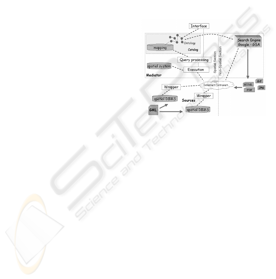
2 AN OVERVIEW
Figure 1 shows the basic architecture of our
approach. It has two main sections: mediator and
sources (Wrappers). Mediator stores Spatial
resources (named GML resources) and has the main
logic for executing the spatial queries to obtain non-
Spatial resources (non-GML resources) related to
the GML resources. Mediator has two aims: on the
one hand, it relates GML resources and makes it
possible to search for them, and on the other hand, it
carries out the search for non-GML resources.
Figure 1: Architecture of the approach.
Non-GML resources (web pages, gif, pdf, etc)
are stored on “Internet”, though we suppose a copy
is stored in the Search Engine. In the implementation
of this approach we have based our work on the
Google Search Engine. To be precise, we have used
the Google Search Appliance (GSA). It is an
integrated hardware and software product designed
to give businesses the productivity-enhancing power
of Google search (Google, 2006). However, though
our implementation has been limited to Google
Search Appliance, every feature of this approach can
be applied over Google Search Engine or other
Search Engines. For this reason, in this paper we use
the term Search Engine in a general way.
GML resources are stored in the sources (in the
same or different locations), whose purpose is that of
executing the queries received from the mediator
and returning the results.
The main task of an integration mediator is to
provide users with a unique interface for querying
the data, independently of its actual organisation and
location (Levy, 2000). This interface, or global
schema, is described as an ontology.
SEARCH ON THE WEB WITH SPATIAL CRITERIONS - Improving a Search Engine with Spatial Queries
383
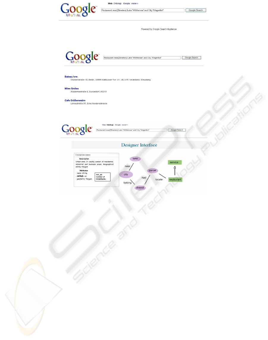
Figure 2: Spatial Query.
Figure 3: Results.
Figure 4: Ontology in the User Interface.
To evaluate a user query expressed in terms of
the ontology, the mediator translates it into one or
more queries on the GML sources. For this purpose,
we need to establish a correspondence between each
source and the global ontology. This correspondence
is described by a mapping.
When the correspondence between each source
and the global ontology has been carried out, the
system can execute spatial queries over the GML
resources, and then over non-GML resources. In
order to execute the queries, we need a spatial query
language over the ontology and an execution plan in
order to know what GML or non-GML resources
satisfy the query. If a source s can only partially
answer a query, then the query is decomposed into
two parts: one to be fully answered by s, the other
part being sent to the other sources. In this case, it
needs a variable binding algorithm and a query
execution plan that includes query decomposition
for searching all sources for which there exists a
full/partial binding. This process is discussed in
(
Córcoles and González., 2004).
Therefore, the description of the global schema
in terms of the ontology allows users to formulate
structured queries, without being aware of the source
specific structure.
Figure 2 shows the main query web pages
defined in a prototype that implements the concepts
defined in this paper. Because we have used a
Google Search Appliance - GSA, we have used a
similar web page design to Google. (Note that the
logotype GoogleSpatial is not a Google trademark.
It is only a play on words used in the prototype).
A result page is shown in Figure 3 Here we
group the resources by each result returned for the
GML resources. Finally, Figure 4 shows an example
of our ontology which a user can look at to
understand the available concept in the community.
3 CONCLUSIONS
We have used a system based on a mediator to
execute spatial queries on the web. We distinguish
between non-spatial resources and spatial resources.
The non-spatial resources are represented by HTML,
GIF, PDF, etc., and the spatial resources are
WEBIST 2007 - International Conference on Web Information Systems and Technologies
384

represented by Geographical Markup Language -
GML.
GML resources can be stored in different
sources. For this reason, we have defined an
execution plan (QEP) to optimize the execution.
QEP has two phases, the first one is executed over
GML resources and the second phase is executed
over the Search Engine. QEP processes the user
queries and sends full or partial queries to the GML
sources. The sources return alphanumeric values
(keys of the concepts), and these values are sent to a
Search Engine to search for the associated resources.
Non-GML resources are riddled with spatial
information in an unstructured textual way, and
resources have spatial information, i.e., geometries,
and structured textual descriptions. Therefore, in
order to relate GML resources to non-GML
resources we try to find the value of the keys of the
concepts involved in the spatial query in the Search
Engine.
Future work foresees an approach for
automatically loading the mapping rules in the
Catalog. Moreover, we are performing a study in
order to exhaustively validate the quality of the
results. Furthermore, in order to increase the
usability of the query language, adaptative
techniques are being studied to help the user to
understand the ontology and write the queries.
ACKNOWLEDGEMENTS
We are grateful to Sitesa – Grupo (Spain) for kindly
allowing us to use its Google Search Appliance and
its infrastructure.
They contributed to making our work a
reality.
REFERENCES
Boucelma, O., Essid, M., Lacroix., Z., 2002. A WFS-
Based Mediation System for GIS Interoperability. In
Proceedings of ACM-GIS 2002. 10th ACM
International Symposium on Advances in Geographic
Information Systems,. McLean, USA.
Cluet, S., Veltri, P., Vodislav, D., 2001. Views in a large
Scale XML Repository. In Proceedings of VLDB,
Rome, Italy.
Córcoles, J., González, P., 2003. Querying Spatial
Resources. An Approach to the Semantic Geospatial
Web. In Proceedings of CAiSE'03 workshop "Web
Services, e-Business, and the Semantic Web (WES)”.
Lecture Notes in Computer Science (LNCS) Springer-
Verlag, LNCS 3095, pp. 41-50.
Córcoles, J., González, P., López-Jaquero, V., 2003.
Integration of Spatial XML Documents with RDF.
International Conference on Web Engineering
(ICWE03). Spain. Lecture Notes in Computer Science
(LNCS) by Springer-Verlag. LNCS 2722, pp. 407-
410..
Córcoles, J., González, P., 2004. Integrating GML
Resources and Other Web Resources. DEXA’04
Workshops. 1º International Workshop on Geographic
Information Management, GIM 2004. IEEE Computer
Society, pp. 872-877.
Córcoles, J., 2005. Integración de Recursos Espaciales y
No-Espaciales en la Web: Un Acercamiento a la Web
Semántica Geoespacial. Ph.D. Dissertation. UCLM
University, Spain, pp. 244.
Egenhofer, M., 2002. Toward the Semantic Geospatial
Web. In Proceedings of ACM-GIS 2002. 10th ACM
International Symposium on Advances in Geographic
Information Systems, McLean, USA.
Google, 2006 www.google.co.uk/enterprise/gsa.
Acceded in 2006
Gupta, A., Marciano, R., Zaslavsky, I., Baru, C., 1999.
Integrating GIS and Imagery through XML based
information Mediation. Integrated Spatial Databases:
Digital Images and GIS. Lecture Notes in Computer
Science. Springer-Verlag, 1737, pp. 211-234.
Levy, A.Y., Rajaraman, A. and Ordille, J. Querying
Heterogeneous Information Sources Using Source
Description. In Proc. of the Int. Conference on Very
Large Databases, pp.25-262. India.
Levy, A.Y., 2000. Logic-Based Techniques in Data
Integration. In Jack Minker, editor, Logic Based
Artificial Intelligence, Kluwer, p.p 575-595.
Maps, 2006 Maps.google.com. Acceded in 2006
Open Geospatial Consortium, 2003 Open Geospatial
Consortium, 2004. Geography Markup Language
(GML) v3.1.1.
Papakonstantinou, Y., García-Molina, H. and Widom, J.,
1992. Object Exchange Across Heterogeneous
Information Sources. In Proc. ICDE Conf. TSIMMIS
project.
SEARCH ON THE WEB WITH SPATIAL CRITERIONS - Improving a Search Engine with Spatial Queries
385
