
A LOCATION BASED E-LEARNING SYSTEM
Georg Schneider, Patrick Arnoldy and Tobias Mangerich
University of Applied Sciences Trier, Schneidershof, 54293 Trier, Germany
Keywords: Web-based Teaching and Learning Technologies, Content-based and Context-based Learning.
Abstract: Much information is inherently coupled with a certain place. Accessing this information at the given place is
often the key to understand it or at least it helps understanding the information much better than accessing it
elsewhere. e-Learning systems free the learners from the chains of time and place. However they are
normally used with PCs or laptop computers either at home or at certain premises. Especially in a city like
Trier, which is full of history, it is easy to verify that learning about the Romans and seeing a picture of a
historic site is different to the real world experience of this site. This reflection leads us to the idea to extend
the capabilities of a conventional E-learning system in a way that information can be accessed where it can
be understood more easily, i.e. on its place. Therefore we have extended the system MOVII (Moving
Images and Interfaces), which is a flexible and visually appealing E-learning Platform with a possibility to
geocode information entities and to access them appropriately.
1 INTRODUCTION
Trier is the oldest city of Germany. Therefore it is
not astonishing, that it is a place, where everybody
can observe many tourists walking through the city,
contemplating roman ruins and other historic sites
from the different centuries. One could ask the
question, why people are doing this instead of sitting
at home and reading a book about the city or
watching a report on a DVD. However the answer
would be relatively easy to give: To walk through
the historic sites allows the tourists to gain a much
deeper insight. In the case of Trier this means that
e.g. walking through a gigantic roman city gate is
obviously a different experience than looking at a
picture of the same building. You can see the site
from different angels, you can touch the stone, and
you can experience the site with all your senses. The
emotions that arise from this visit are completely
different to the emotions that come from reading a
book or watching a movie. It is easy to verify from
personal insights that we remember facts about
places we have visited much better than about places
we have only read about.
What are the consequences of this observation?
Much information seems to be inherently coupled
with a certain place and accessing this information at
this place helps to acquire knowledge or to learn
about this place more efficiently.
The last sentence already implies what the core
of a tourist visit of a city really is: It is
learning about the city, about certain periods, about
architecture, etc..
This again leads to another question. How do we
learn today? Watching at schools and universities,
etc. one can see that in the last years a trend towards
computer supported learning becomes more and
more common. Today many e-Learning platforms
are available, like Ilias (Kunkel 2004), WebCT
(Gurrie 2006), MOVII (Kluge et al. 2004) and many
more. These platforms are well suited to make
(pedagogically carefully elaborated) learning
materials available wherever the user has network
connection and a suitable access device however
there is no concept to make the information
available where it is meaningful to deliver this
information.
This paper will describe a generic concept and a
prototypic realization for an extension on the
example of the e-Learning platform MOVII, which
will be able to attach location information to the
learning content.
The paper will start with the discussion of the
different concepts of e-Learning platforms and
location based guides. Afterwards, we will present
the concept how to attach location information to e-
Learning content. Finally we will present the
realization of the system. The paper will close with
some concluding remarks.
527
Schneider G., Arnoldy P. and Mangerich T. (2007).
A LOCATION BASED E-LEARNING SYSTEM.
In Proceedings of the Third International Conference on Web Information Systems and Technologies - Society, e-Business and e-Government /
e-Learning, pages 527-531
DOI: 10.5220/0001275605270531
Copyright
c
SciTePress

2 LOCATION BASED GUIDES
VERSUS E-LEARNING
SYSTEMS
Several projects already deal with the issue of
location based services.
The Moses project (Schneider and Greving
2005) for example used infrared beacons for position
tracking, a commercially available PDA and a
proprietary content management system for
multimedia content.
In the area of mobile tourist and museum guides,
different hardware settings are used for tasks like
tracking, the delivery of information or the network
connection. The focus however lies mainly on the
accurate delivery of additional content to the
exhibits or points of interest (e.g. Rocchi et. al.
2004, Cheverst et. al. 2000, Malaka and Zipf 2000 or
commercial systems like the “Mobile Travel Guide”
(Moltomedia 2006) or the BUGAButler (Blis 2006),
only to mention some of them). One drawback of
these systems is that they do not have an explicit
pedagogic background or a special learning focus for
the information that they deliver, whereas
presentations for e-Learning systems have exactly
this focus. In the museum scenarios the user is
guided by the concept of the museum director who
installed the exhibits in the real world. In the case of
the tourist guides the user is often guided by the
incidental regional proximity of Points of Interest.
Another disadvantage is that the information is
usually stored in proprietary formats and is therefore
hardly reusable.
On the other hand there are mobile extensions to
e-Learning systems. Trends for mobile learning
(Kuszpa 2005a) rather deal with the idea to access
learning materials with arbitrary devices over
different networks. “Pocket University” from the
Distance Learning University Hagen (Kuszpa
2005b) tries to reinforce learning using a mobile
phone or a PDA to access material, which has been
already worked on. The contribution from the
University of Klagenfurt, Austria, to the Mobilearn
project (Hitz and Plattner 2004) describes an
innovative idea to augment paper based learning
resources using a PDA but does not regard further
the geographical location of the learning content.
The commercial products “Mobile Learning
Platform” and “Mobile Learning Engine” (Elibera
2006) also focus more on the idea of testing and
reinforcing already accessed material. The
University of Birmingham (Lonsdale et. al. 2005)
has implemented a system for museum visits, which
targets to support learning activities, which take into
consideration the location of the user. However the
system rather behaves like a conventional location
based system. It supports the learning activities of a
learner by delivering additional information to an
exhibit but it does not guide the learner through the
museum in order to achieve a certain learning
outcome. Furthermore the system also uses an
XML-based but not standardized format.
The conclusion of this discussion is that a
location-based learning system should take into
account the following points:
Focus on Learning
The system shall provide the possibility to design
courses focussing on special subjects and learning
outcomes. Furthermore there should be a relation
between conventional learning situations and
materials and the geocoded equivalents in a way
that a learner can prepare or reinforce the mobile
learning experience. Ideally she can use the same
learning path in the mobile and in the
conventional e-Learning setting.
Reusability of content
It is crucial to choose extending an e-Learning
system towards location based capabilities. This
procedure guarantees that already available
content can be reused in mobile scenarios.
Furthermore it stimulates the generation of
content for special purposes, which can vice versa
be used also in a non mobile setting.
Additionally, if the e-Learning system respects
already existing standards (e.g. Scorm 2006) the
exchange of learning material with other e-
Learning systems is also guaranteed.
Geocoding of Content
There must be a possibility to attach location
information to learning resources where it is vital.
Learning resources that have no spatial context
(e.g. basic or background knowledge) do not have
to be geocoded.
These remarks also motivate to choose a loose
coupling of the systems in order to be as flexible as
possible.
3 INTEGRATION CONCEPT
In the following section, we will describe the
MOVII system, our integration concept and the
basic architecture.
WEBIST 2007 - International Conference on Web Information Systems and Technologies
528
3.1 The e-Learning System MOVII
As discussed in the preceding section, it is not
meaningful to write a new system from scratch, but
to integrate a mobile extension for a location based
service in an already existing e-Learning system. In
our case this is done on the example of the e-
Learning system MOVII (Kluge et al. 2004). In this
paper, we will only give a short introduction into the
ideas of MOVII, further information can be found at
the project website (www.movii.de).
The system hierarchically structures the learning
content into the following concepts: Module, Act,
Scene, Core and Entity.
The core is an atomic structure, which refers to a
certain learning content. A core can play different
roles. It can be the core content to learn, as the word
already implies. A core can also be an exercise; it
can be more detailed information to this topic or a
link to a completely different topic area. Further-
more the same core can play different roles in
different learning scenarios. Whereas it can be an
exercise in one scenario, it might be the relation to a
different topic field in another setting. These
different potential roles are called the entities of the
core.
Related cores are grouped into scenes. Scenes
belong to acts, which again belong to a module. A
module covers a coherent topic field. In order to
create a certain learning path a sequencing tool is
used, where the teacher can arrange cores using a
graphical user interface.
3.2 Mapping Learning Objects to the
Real World
The task of the mobile extension is to find a way to
attach positions in the real world to learning objects.
In many scenarios it is sufficient to know the
coordinates (longitude and latitude) of a point. For a
museum context however one can quickly verify that
more information is needed. Here, different cores
can be on the same coordinate but in different stories
of a building (altitude). They can also be very close
together and the orientation of the user is vital
information. In a museum it is crucial to know if a
user looks in the direction of an exhibit or if the
exhibit in her back. Both situations correspond to the
same coordinate likewise.
The mobile extension basically structures its
content into Points of Interest (POIs). For the
reasons mentioned above we differentiate POIs and
“inner” POIs. POIs can be specified using longitude
and latitude (and can be identified e.g. using a GPS
receiver). Inner POIs must be specified using other
means, e.g. IDs (from Infrared beacons or RFID
tags).
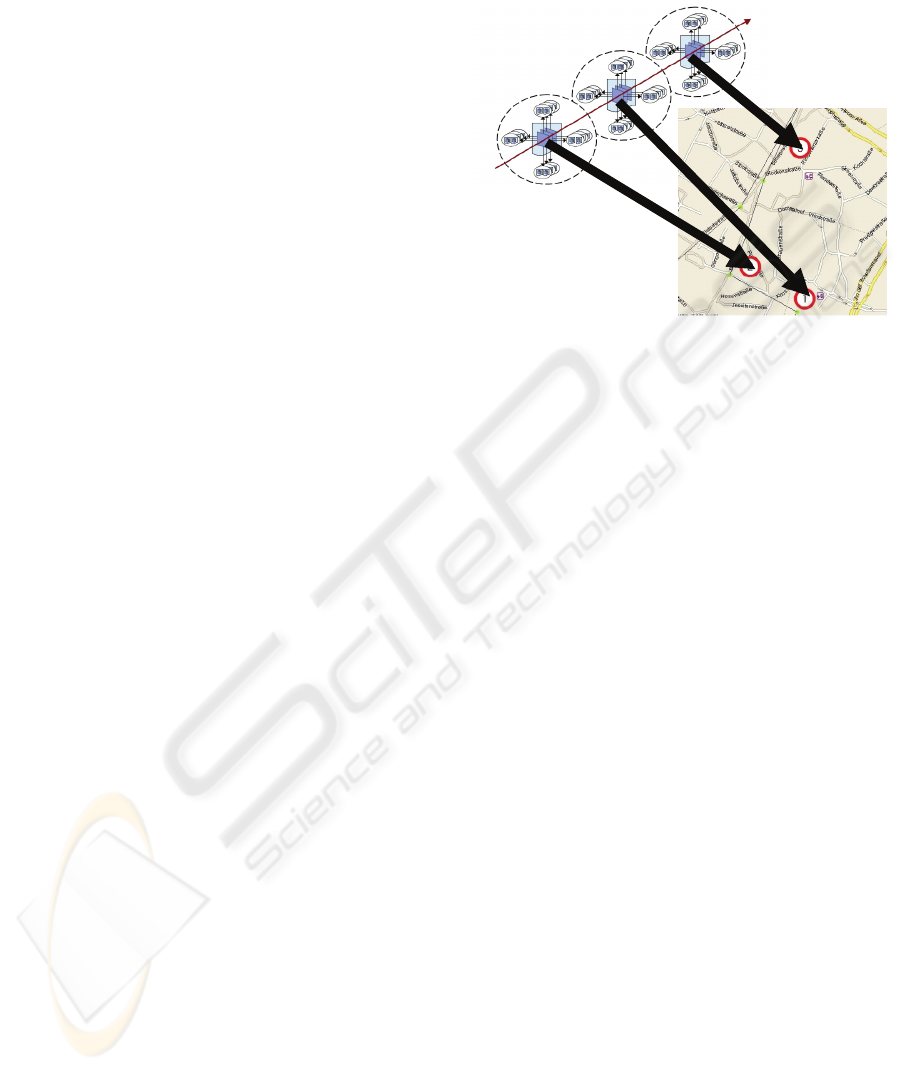
Figure 1: Mapping cores from a learning path to
coordinates in the real world.
Figure 1 illustrates the idea of geocoding MOVII
cores. The cores are already assembled to a learning
path, whereas the cores in the middle specify the
basic learning content and the cores grouped around
in a shamrock like manner are exercises, examples,
and links to other topic areas or in-depth
information.
4 ARCHITECTURE
The architecture of the mobile extension to MOVII
is based on a loose coupling between the systems.
The mobile extension retrieves the information from
MOVII and caches it in a local database via a web
service interface, i.e. cores, learning paths, etc.. This
allows an efficient interaction between the two
systems since only an API is needed to interact with
the e-Learning system. Interaction with other e-
Learning systems will be also relatively easy to
create because the system has not to be altered.
Additionally it is not necessary to copy the whole
database in one cycle, which would require a long
pre-processing time. The local cache will be filled
over time. Furthermore this procedure will speed up
the response times since the already retrieved
content can be serviced locally.
The relation between cores and positions is done
using a specialised authoring tool, the “Route
Designer”. Right now we only support GPS
coordinates. Cores can simply be dragged and
dropped on a certain position on the map. A local
database finally stores the information between
cores and coordinates.
A LOCATION BASED E-LEARNING SYSTEM
529
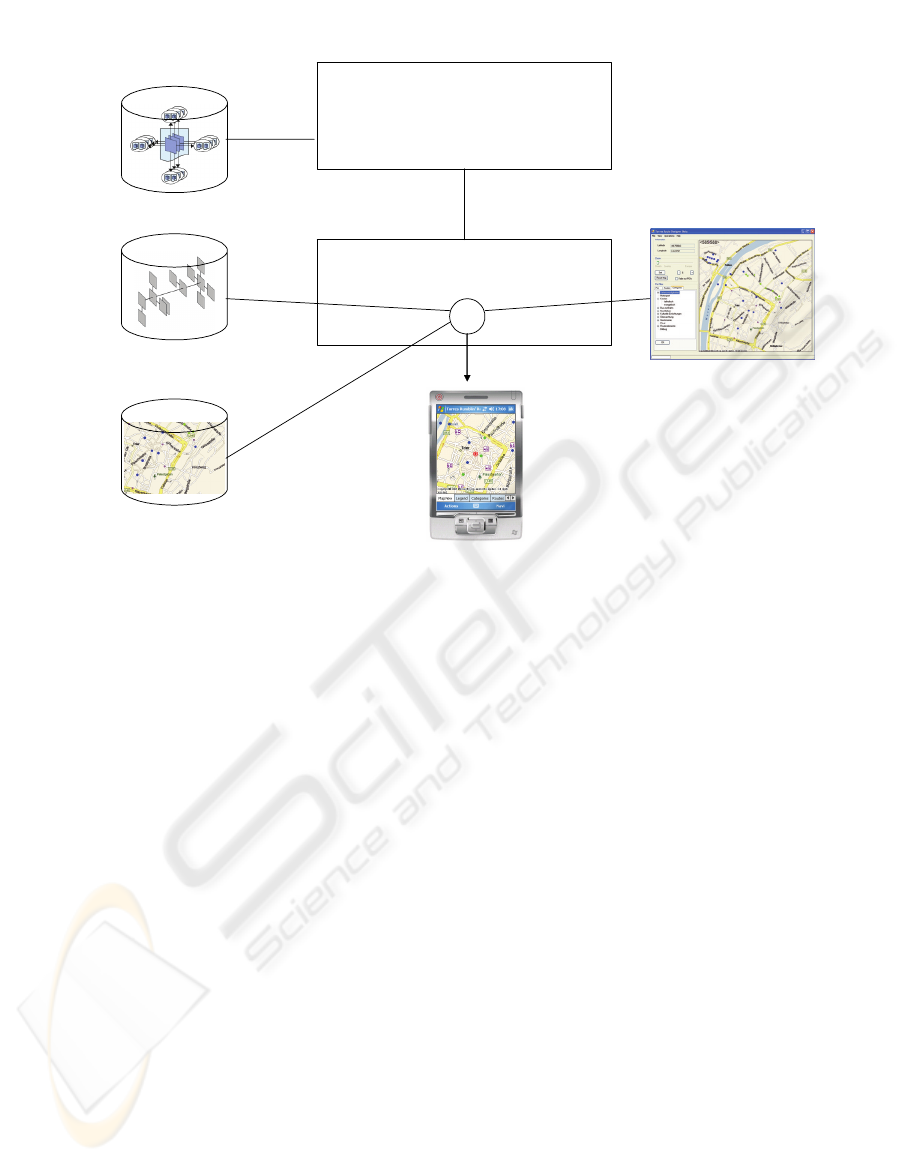
In order to give the user an orientation on his
mobile device, a map server is included, which
visualizes the current position, of the user.
Additionally the learning path can be visualized on
the map. Routing information how to get to the next
Point of Interest can also be displayed.
Finally a mobile device with a GPS receiver can
access the content of the system via a wireless
network (e.g. UMTS or WLAN). The GPS receiver
tracks the user’s position. If she approaches a
referenced location, the system can activate a core
and display the belonging information on the mobile
device.
5 IMPLEMENTATION
The system is mostly written in C# and uses a web
service interface in order to retrieve the information
from the MOVII e-Learning system. Afterwards the
data is stored in the local cache of the mobile
extension, which is a MySQL Database. The system
uses the Apache Torque extension (see Torque
2006) as object relational mapping tool.
The authoring tool, which creates the relation
between cores and coordinates with the use of a
graphical user interface, communicates with the
system via a web service interface over an Apache
web server. This authoring tool, the so called Route
Designer is also a C# application.
As a map server we are using Microsoft
MapPoint 2006, which runs as a web service under
IIS. It also offers possibilities to scale the maps and
to display routing information.
The PDA is a Fujitsu Siemens Pocket LOOX
N560. The device has a 624 MHz Processor, based
on Intel XScale architecture. The PDA uses an
integrated GPS receiver, which supports the NMEA
0183 standard. It has a VGA display with a
resolution of 480* 640 pixels. The device has
WLAN, Bluetooth and Infrared connection.
6 CONCLUSIONS AND FUTURE
WORK
Integrating location information into e-Learning
systems is a very promising way to for tourist
information systems. The system can reasonably
guide visitors through cities along nicely elaborated
learning path. They do not have to switch from one
topic to another, only because POIs are next to each
other. Furthermore the information is reusable and
does not “belong” to a specialised, proprietary
system. We strongly believe that his fact also
motivates authors to create high quality content.
The realization has proved that the mobile
extension does not have to be closely integrated into
the e-Learning system. We have made good
experiences with our loose coupling approach and
MOVII
Web Service
Interface
Mobile Extension
Cache
Map Server
Authoring
Tool
Mobile Device
Learning
Content
+
Figure 2: System Architecture.
WEBIST 2007 - International Conference on Web Information Systems and Technologies
530

we hope to be able to support also other e-Learning
applications as well.
In the future we will address several extensions.
Currently we are working on a much more
sophisticated concept where cores can belong to
more than one location, etc.. Furthermore we can
only support GPS coordinates for our objects right
now. In the future we want to implement a position
abstraction layer, which can equally support other
tracking technologies, for example Infrared or RFID.
Another challenge is the relation between the
mobile and the PC based version of the learning
path. A deeper integration of both versions in a way,
that the mobile extension is much more aware of the
learning advances in the PC based version and vice
versa is desirable.
Additionally the integration of community service,
where users can interact with each other and
communicate about learning objects and POIs would
be a further improvement of the system.
REFERENCES
Blis 2006. Blis Informationssysteme, Retrieved November
11, 2006, from http://www.blisinfo.de
Cheverst, K., Davies, N., Mitchell, K., Friday, A.,
Efstratiou, C., 2000. Developing a context-aware
electronic tourist guide: Some issues and experiences.
In: Proceedings of the CHI 2000, Amsterdam,
Netherlands
Elibera 2006. eLibera Meisenberger & Lazaridis OEG,
Retrieved November 12, 2006, from
http://www.elibera.com
Gurrie, J., 2006. WebCT Campus Edition 6: An Overview.
In Proeedings of the 5th Annual WebCT European
User Conference 27 February - 1 March 2006,
Edinburgh, Scotland
Hitz M., Plattner S., 2004. PaperLinks – Linking Printouts
to Mobile Devices. In: Proeedings of the International
Conference on Mobile Learning, MLEARN 2004, July
5–6, 2004, Rome, Italy
Kluge, F., Haberkorn, M., Regueiro-Lopez, H., 2004.
movii: Medien bilden – Medienkompetenz oder die
Befähigung zum Bild. In: Bett, K., Wedekind, J.,
Zentel P., (Eds.): Medienkompetenz für die
Hochschullehre. Medien in der Wissenschaft, Bd. 28,
2004, Waxmann-Verlag, Berlin, Germany
Kunkel, M., 2004. ILIAS 3 – Innovationen und
Perspektiven. In: Proceedings of the ILIAS Konferenz
2004, Pädagogische Hochschule Zürich, 29.9. – 30.9.
2004, Zürich, Switzerland
Kuszpa, M., 2005a. The Future of Mobile Learning – A
Survey of Expert Expectations about learning on
mobile phones. In: Proeeding. Online Educa 2005,
Book of Abstracts, Berlin, Germany
Kuszpa, M., 2005b. Virtual University goes mobile:
Experiences with Mobile Learning at the University in
Hagen. In: Center of Distance Education (eds.):
Proceedings "Virtual University: models, tools and
practice", 2005, Warsaw, Poland
Lonsdale, P., Baber, C., Sharples, M., Byrne, W.,
Arvanitis, T.N., Beale, R., 2004. Context Awareness
for MOBIlearn: Creating an engaging learning
experience in an art museum. In: Proceedings of the
International Conference on Mobile Learning,
MLEARN 2004, Rome, Italy, July 5–6, 2004, Rom,
Italy
Malaka R., Zipf, A., 2000. Deep map – challenging it
research in the framework of a tourist information
system. In: Buhalis D., Fesenmaier, D. R., Klein, S.,
(Eds.), Information and communication technologies
in tourism. Springer-Verlag, 2000, New York, USA
Moltomedia 2006. Retrieved November 11, 2006, from
http://www.moltomedia.de
Rocchi, C., Stock, O., Zancanaro, M., Kruppa, M., Krüger,
A., 2004. The Museum Visit: Generating Seamless
Personalized Presentations on Multiple Devices. In:
Proceedings of IUI 2004, Jan. 13-16, 2004, Island of
Madeira, Portugal
Schneider. G., Greving, M., 2005. MOSES - the Mobile
Service and Exploration System. In: Proeedings of the
Video Sessions "3rd International Conference on
Pervasive Computing, Pervasive 2005, 8-13 May
2005, Munich, Germany
Scorm 2006. Sharable Content Object Reference Model,
Retrieved November 12, 2006, from
http://www.adlnet.gov
Torque 2006. Retrieved November 12, 2006, from
http://db.apache.org/torque/
A LOCATION BASED E-LEARNING SYSTEM
531
