
MOBILE CHASE
Towards a Framework for Location-Based Gaming
Mirko Fetter
Faculty of Media, Bauhaus University Weimar, Bauhausstr. 11, Weimar, Germany
Markus Etz, Heiko Blechschmied
Graphic Information Systems Department, Fraunhofer Institute for Computer Graphics
Fraunhoferstr.5, Darmstadt, Germany
Keywords: Location-based Gaming, Pervasive Gaming, Mobile Computing, Computer Supported Cooperative Play.
Abstract: Pervasive Gaming and Location-based Games in particular have gained more and more attention recently.
Researchers from a variety of fields, media artists, mobile service providers as well as the entertainment
industry all seem to have their specific interests in this area. Today a couple of different games exist from
basic applications that are already available to the consumer market to bleeding edge research projects. In
this paper we introduce a framework for Location-based Gaming that on the one hand helps with the
development of market ready games. On the other hand it serves as a toolkit for researchers aiming to
rapidly develop Location-based Games, not having to deal with implementation details far away from their
research interests in order to focus on their specific research aspects.
1 INTRODUCTION
Modern information and telecommunication
technologies offer more and more possibilities for
interaction, entertainment and recreational activities.
In Pervasive Games the physical world merges with
the virtual one and thus offers new adventures and
experiences for the players by utilizing these
technologies like mobile devices, tangible user
interfaces or augmented reality. To increase the level
of immersion these games incorporate the players’
context by means of e.g. time, place, or personal
data.
Location-based Games are one of the many areas
where the concepts of Pervasive Gaming come to
life. Thereby single players or teams perform tasks
in specified scenarios using mobile computers like
laptops, personal digital assistants or mobile phones
in combination with wireless communication and
location-sensing technologies, having the real world
as their game board.
There are many reasons to be interested in the
current development of Location-based Games. On
the one hand there are clear market issues. As
current video and computer games are already
selling to a billion dollar market and the analyst
Forrester (Forrester Research Inc., 2000) stated that
Pervasive Gaming will gain a big market share there
are also other interested parties besides the game
development companies. The mobile service
providers might see the possibility that Location-
based Games could be a real driver for Location-
based Services and technologies like 3G. On the
other hand Pervasive Games may help researchers to
test and analyze the use of a wide spectrum of
technologies in game scenarios. The findings and
things learned could then be transferred to other
ubiquitous computing application fields.
With the framework presented in this paper we
introduce a tool which can serve as a solid base for
developers to implement their own gaming ideas.
Therefore the framework not only takes care of data
management and communication tasks but also
delivers a pattern for the modelling of Location-
based game content on server- and client-side.
The remainder of the paper is organized as
follows: In section 2 we present work which has
been done on the area of Location-based Games in
several fields. In section 3 we outline the basic
98
Fetter M., Etz M. and Blechschmied H. (2007).
MOBILE CHASE - Towards a Framework for Location-Based Gaming.
In Proceedings of the Second International Conference on Computer Graphics Theory and Applications - AS/IE, pages 98-105
DOI: 10.5220/0002077400980105
Copyright
c
SciTePress

requirements of the framework and give a detailed
overview of the technical concepts. Further on, in
section 4, we describe “Mobile Chase”, a
prototypically-implemented game based on the
framework. In the final section we outline future
work and draw conclusions.
2 RELATED WORK
Pervasive Games can appear in many forms as
described by Magerkurth et al. (Magerkurth, Cheok,
Mandryk, & Nilsen, 2005), the genres span from
smart toys over augmented tabletop games to a form
that he calls Location-Aware Gaming. Thereby the
approaches from different genres sometimes are
mixed in one system and bring up interesting
combinations that are hard to differentiate.
Location-based Games can be distinguished by
the fact that they use the position of the player in the
real world as a major input to the game process. In
these games the real world is seen as a game board
so they can be considered as the consequent answer
to ideas like Live Action Role Playing Games -
which bring classic Pen and Paper Role Playing
Games to life in events lasting several days -
Alternate Reality Games like “The Beast”
(McGonigal, 2003) - that use the full bandwidth of
modern media and communication technologies to
blur the borders between game and reality - and
modern video games.
A couple of games and systems have already
been developed coming from fields like research,
media art, or the industry. While last mentioned
according to Jegers (Jegers, 2004) only use a small
part of what the Pervasive Gaming paradigm offers
and are technically reduced to fit today’s user
devices, some of them are already quite successful
from a market perspective. For example the Tokyo
based game “Mogi, Item hunt” (KDDI, 2003) where
it is the player’s task to collect virtual items spread
over the city and to complete different collections of
items. Or the first commercial Location-based Game
“Botfighters” (Botfighters.com, 2005) developed by
“It’s alive” which appeared in 2001 and is about to
be released in version 2.0 where the user plays a
robot and has to solve missions hunting other
players. Both games can be run on standard mobile
phones supporting J2ME, using Cell-ID based
positioning methods.
The approach of Blast Theory, a group of
London based artists seems in contrast very
different. They developed a couple of Location-
aware Games like “Can You See Me Now?”
(Flintham et al., 2003) or “Uncle Roy All Around
You” (Benford et al., 2004) that come to life on the
streets as a sort of artistic event or interactive
performance. In contrast to the commercial games
mentioned before, these events take place for a fixed
time only with a limited number of participants. This
is somehow reflected in many details of the
realisation. Professional actors interact with the
players. In addition, as the devices are provided to
the players for the time they play, the technological
constraints to cope with are fewer than the
constraints commercial game developers have to
take care of, which leads to more sophisticated game
interfaces and a gain in the level of immersion
during play time.
Though Blast Theory collaborates with different
research institutes their interests seem to derive from
their artistic background in the first instance.
Therefore we also want to mention three
contributions made by the research community.
In “Pirates!” (Björk, Falk, Hansson, &
Ljungstrand, 2001) the homonymous classic
computer game from the renowned game designer
Sid Meier was brought to real life. The task of the
player is to “sail” between different locations,
representing islands, to search treasures and battle
near players all by using handheld computers,
WLAN and proximity sensors.
To prevent a virus from escaping from a campus,
the players of “Epidemic Menace” (Lindt,
Ohlenburg, Pankoke-Babatz, Prinz, & Ghellal,
2006), a pervasive crossmedia game, are equipped
with a variety of mobile devices - some of them
offering mobile Augmented Reality (AR).
Another research project dealing in the area of
Location-based Games was the publically funded
German research project GEIST (Holweg,
Schneider, & Göbel, 2004). The goal of the project
was to provide pupils with historical information via
means of edutainment. Virtual ghosts from the past
gave the pupils tasks by which they could learn facts
about the town history. Therefore the children were
provided with a wearable computer connected to
various positioning devices and a semi-transparent
AR-display on which digital reconstructions of
historical buildings were shown on their original
position together with the virtual ghosts.
As we can see, a lot of work has been put into
the field of Location-based Gaming, and a lot of
good ideas and systems have been developed.
However it seems that many implementations are
tightly bound to the implemented game concept.
Therefore our approach is a more generic one, not
focusing on the game idea, but on the underlying
MOBILE CHASE - Towards a Framework for Location-Based Gaming
99
concepts that are common to every Location-based
Game. In the following we present our proposal for
that generic approach.
3 A FRAMEWORK FOR
LOCATION-BASED GAMES
In this section we describe the requirements we had
concerning the framework, which will directly lead
us to the concepts and implementation details.
3.1 Requirements
As mentioned it was our aim to define a generic
platform for Location-based Games. Therefore a
major requirement was to define the design of the
framework as openly as possible in order to allow a
variety of different game ideas. The framework
should give the game designers the freedom to
implement their concepts without being constrained
to technical shortcomings or bound to specific
devices or services. For example the selection of the
best fitting positioning technology should be in the
hands of the game developer not limiting him to a
specific accuracy or the fact that the game can only
be played outdoor, etc.
Therefore we defined a J2ME enabled mobile
device supporting MIDP 2.0
(SUN Microsystems Inc., 2002a) and CLDC 1.1
(SUN Microsystems Inc., 2003) with network access
and some positioning mechanism - which can be at a
low level like an address input - as the minimal
specification for a mobile player.
Though there already exist some great
frameworks, middleware, and platforms for mobile
multiplayer games like Exit Games Neutron 3.5
(Exit Games, 2006), Nokia’s SNAP Mobile (Nokia,
2006), or the proposal of the Mobile Games
Interoperability Forum (Mobile Games
Interoperability Forum, 2002) , their focus does not
lay on supporting Location-based Games. Therefore
another requirement while planning the framework
was to identify those concepts, which are specific to
Location-based Games, and to concentrate on these.
On the other side, this means to clearly omit services
and concepts that can also be found in normal
multiplayer game platforms and often just surround
the actual game like e.g. Competition Management,
Buddy Management or Match Making which are
suggested by the Mobile Games Interoperability
Forum.
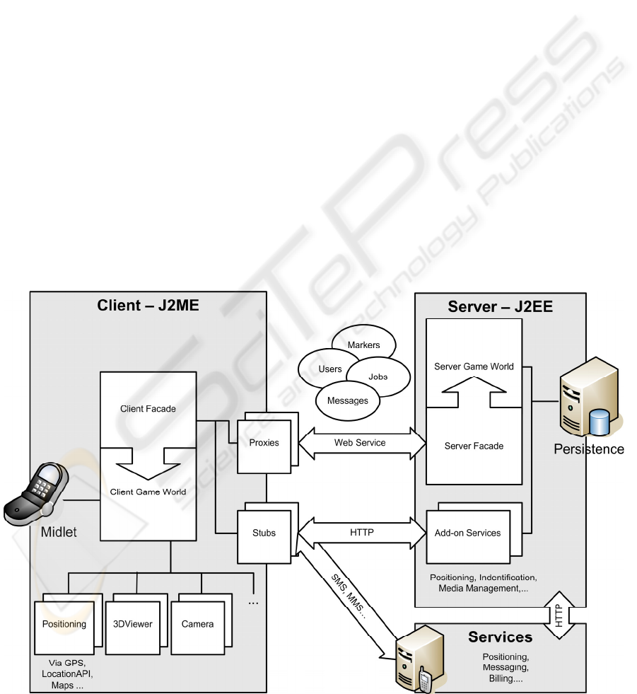
Figure 1: Schematic overview of the framework and its interfaces.
GRAPP 2007 - International Conference on Computer Graphics Theory and Applications
100

3.2 The Framework
The framework is completely implemented in Java
whereby the basic concepts are implemented in a
way that they can be run on devices supporting
J2ME, J2SE or J2EE. The base of the framework
builds a domain model that maps the concepts,
entities and their relationships that can be found in
Location-based Games.
Therefore we have identified four basic entities
that are common to most of the Location-based
Games:
User, Marker, Job and Message. The
class
User represents a player, which would
normally be a human, mobile player. But the
concept also allows to model e.g. virtual players,
controlled by stationary players or the CPU, that
interact with players in the real world. The
Marker
class models places or objects with a position
relevant to the game. Thus a marker can be an actual
object like a house, a monument, or a public display
or just mark a position where a virtual object can be
found like a waypoint or some virtual item that can
be collected by passing by. As
User and Marker
both have a spatial element, their position is
manifested in the class
PositionableObject both
inherit from. Besides the current and last position
stored in the WGS 84 format (NIMA, 1991) the
class holds information like the name, team name, or
an image that can be used for multiple purposes like
an avatar, additional information like the photo of a
place, or visual tags to identify a player or marker
via computer vision.
A
Job describes a single objective that has to be
accomplished. Each
Job has inter alia an owner who
has to complete the task and a subject. To fulfil the
requirement, to restrict the game design as less as
possible, a
Job could comprise and be assigned to
either a
User or a Marker. This offers the
possibilities to design games in which it can be the
job of a player to catch another player, or to find a
waypoint. It is even possible to design games where
a
Marker is in charge of fulfilling a job. For
example some sort of digital artefact like a
Bluetooth beacon could identify players passing by.
The class
Message is modelled in the same open
way to give players the possibility to send messages
to their team mates, to public displays represented
by a
Marker, and so on. It is in the hands of the
game designer whether the text field of the class is
just used to send plain text messages or to utilize this
system and for example XML-Serialization to let the
players exchange collected items, etc. via messages.
Besides these four basic concepts we have
defined one central abstract class, the
GameWorld,
which finds its manifestation on the server and the
client side and has to be implemented by the game
designer. The most important task of the
ServerGameWorld and the ClientGameWorld is
to provide the basic game logic and rules and act as
a Mediator between the single instances. Besides the
methods addressing the entities like e.g.
getJobsByUserID, getLocations, or setJob,
etc. which are already implemented the game
designer has to realize a couple of methods dealing
with the game logic and presentation. Depending on
where the computation can be done these methods
have to be implemented on the client or the server
side in the specific
GameWorld class. These
methods are dealing with the provision of the
playing field as a mobile 3D model or 2D graphic or
the effects it has to the game process when players
update their position or identify other
Users or
Markers.
3.3 Technical Details of the Framework
As mentioned before the framework has been
implemented in Java designed to be as less
demanding on resources as possible. In addition the
use of open standards makes it easier for the later
game developer to make modifications and use
standard tools. Therefore the communication
between the server and the clients is realized as a
web service using SOAP (Gudgin, 2003) instead of
defining a proprietary low-level exchange protocol
of its own.
The server side offers all the methods that are
intended for the client encapsulated in the
ServerFacade utilizing Apache Axis
(The Apache Software Foundation, 2006). The
J2ME clients use kSoap (Haustein, Morgan, Beatty,
& Mcdaniel, 2003) to consume the web service and
also make use of the Façade pattern in combination
with the Proxy pattern. In this way the flow of the
framework-relevant data is tightly packaged and
offered at clear endpoints.
If it is necessary to access other services e.g.
looking up street addresses on GIS servers for
positioning, applications identifying visual tags, or
billing services this has to be done bypassing the
framework’s communication flow - as can be seen in
Figure 1.
MOBILE CHASE - Towards a Framework for Location-Based Gaming
101
4 THE GAME “MOBILE CHASE”
Based on the principle of the good old paper chase,
we all will remember from our childhood days, we
implemented the game “Mobile Chase” in order to
test and refine the functionality of the framework. In
the following we explain how we adapted the
principle of the classic game and adapted it to a
Location-based Game and give some detailed
information on the implementation.
4.1 The Game Principle
Exactly as in the classic archetype a team of players
runs through town marking their route each time
they change direction. A team of pursuers starts with
a several-minute delay in order to track down the
first group. Instead of using chalk arrows, in
“Mobile Chase” the first team has to mark each shift
in direction with a photo, which is then geo-coded
using GPS and uploaded to the server by the cellular
phone.
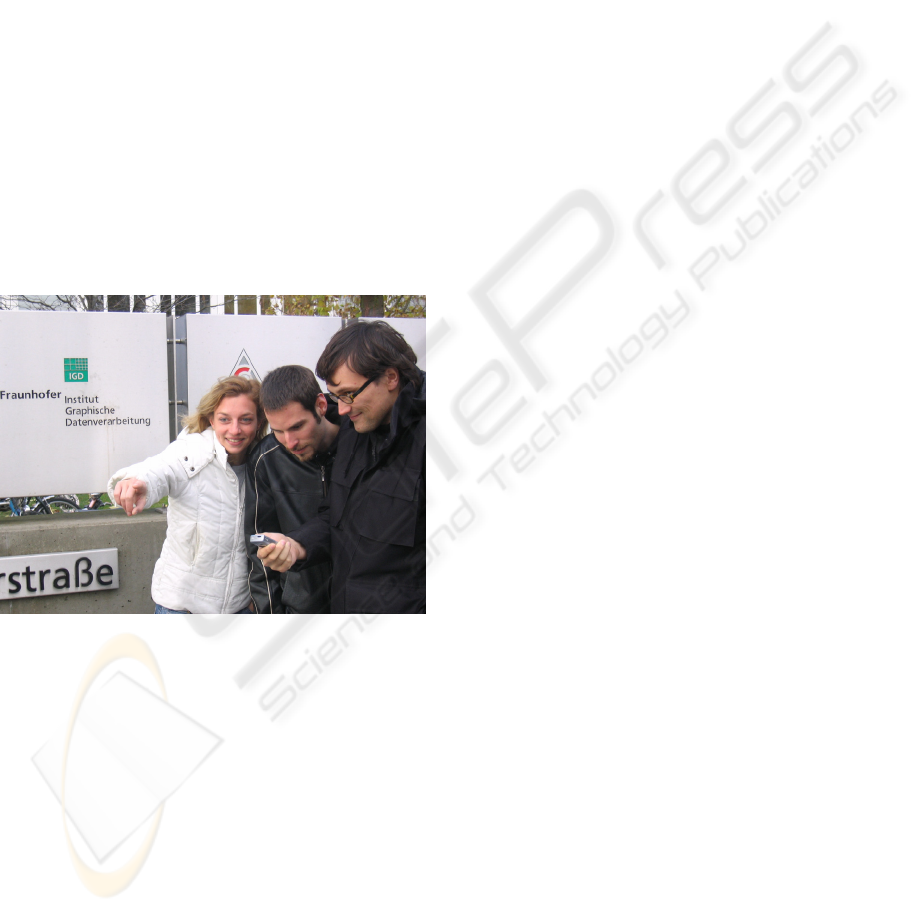
Figure 2: Students Playing “Mobile Chase”.
The pursuing team can use GPS to verify if they
have reached the next ‘marking’. Once the pursuers
are at the right spot, the phone fetches the next
picture from the server, which is superimposed in
correct positional arrangement on a three-
dimensional playing field on the phone’s display
(see Figure 3). This way the pursuing team follows
the route of the first team trying to catch up. When
the first team of players is finally in sight, the
pursuing team can ‘catch’ them via Bluetooth, and
the time is taken. The teams can now change role,
and compete for shorter times.
4.2 Implementation
The client-side implementation of “Mobile Chase”
was done in Java ME, thus allowing, on the one side,
the use of the technologies provided by the
framework and, on the other side, the porting of the
game to a variety of devices.
As mentioned above various tasks had to be
fulfilled in order to implement the game play
planned for “Mobile Chase”. One of the key tasks
was to retrieve the players’ location during the
game. This location was used, on the one side, to
georeference the taken images and, on the other side,
to compare the positions of the pursuing team with
the markings. Here two methods were evaluated
during the implementation phase, one based on the
Location API (JSR 179) (SUN Microsystems Inc.,
2005) provided by cellphones in combination with
positioning data retrieved from the cellular network,
the other one using a satellite-based localization
technology. While from a theoretical point of view
the location data retrieved from the cellular network
could have been used for a first rough localization of
the players, tests showed that the usage of this data
depended on a collaboration with network providers,
a prerequisite which was not met during this project
phase. Therefore the localization in the final
implementation was done using GPS. Technical
obstacles connected to GPS like the impreciseness
related to shadowing effects in city areas were
overcome by allowing a reasonable degree of
inexactness during the game play.
The second main technical task in the
implementation of “Mobile Chase” was the
visualization of the playing field. Here one of the
main tasks, which had to be fulfilled, was the
playability of the game and the satisfaction of the
players. On the one side, the locating of the markers
should not be made too easy for the pursuing team
as this would reduce the “fun factor” of the game
and make it too boring for the players. On the other
side the team should be provided with enough hints
allowing to find the markers’ position in the real
world and to catch the first team of players.
We decided to use a three-dimensional playing
field, an adaptation of the “Mobile 3D Viewer”-
Technology developed at Fraunhofer-IGD
(Blechschmied, Coors, & Etz, 2006), which is based
on the Mobile 3D Graphics-API (JSR 184)
(SUN Microsystems Inc., 2002b) and allows the
visualization of three-dimensional virtual worlds on
mobile devices. As described in chapter 4.1, the
markers are located in correct position relative to
each other on the playing field, allowing the players
GRAPP 2007 - International Conference on Computer Graphics Theory and Applications
102
to deduce information out of the playing field like
the distance and the direction from one shown place
to the next one. Technically the visualization of the
markers was realized by using textured cuboids
which were added to the 3D scene. By that it was
possible, on the one side, to support the pursuing
team in their task without, on the other side,
providing the players’ with too much information
like in a regular street map where the additional
information like the road names would have affected
the complexity of the players’ task.
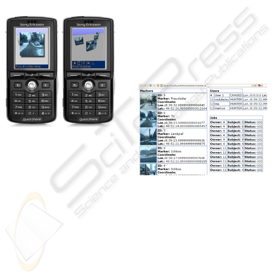
Figure 3: Zoomed view of the next Marker and a view of
the 3D display of the playing field showing four Markers
and the game menu.
Another main technical element of the client-side
application was the implementation of a module,
which allows the first team to use the camera
integrated in the mobile phone to generate the
markers and to transfer the pictures to the game
server. For this task the Mobile Media API (JSR
135) (SUN Microsystems Inc., 2006b) was used.
Here the central class
Manager of the API allows
the access to the resources of the mobile device like
the video stream of the integrated camera. After
having made a photography, the user is shown the
picture on the screen, giving him the possibility to
accept the picture and send it to the game server
using a HTTP-connection. As the photos which are
taken by the first team are to be integrated into the
playing field as textured cuboids, the transferred
photos are afterwards scaled to a size of 128 x 128
pixels on the server. This is done due to the
prerequisite of the Mobile 3D Graphics-API only
allowing textures with a side length of 2
x
.
To geo-reference the taken photos, an external
GPS device was connected to the mobile phone
using the Bluetooth API (JSR 82)
(SUN Microsystems Inc., 2006a). Here the data
retrieved from the GPS device in form of the
NMEA-protocol - a protocol containing amongst
others the retrieved position - were parsed on the
mobile device and used to determine the position of
the players. The identification of the first team at the
end of the game was another task where the
Bluetooth-technology was used. By using the class
BTDeviceDiscovery the pursuing team starts a so
called discovery process scanning for other
Bluetooth-enabled devices in its range, usually a few
meters. The scanned Bluetooth-addresses are sent to
the game server, where the addresses from
ServerGameWorld and ClientGameWorld are
compared. If one of the scanned addresses
corresponds to the Bluetooth-address of the first
team’s device, the job is closed and the pursuing
team wins the game.
Figure 4: Web-interface for the game-player.
To demonstrate the flexibility of the framework
an additional web-interface was realized. This
interface based on the functions offered by the
ServerFacade allows the retrieval of the current
markers, users and their jobs and their representation
in table form and the reset of the game world. While
the different teams are playing “Mobile Chase” on
their mobile devices, this web-interface allows the
online administration of the game via a game master
or the inclusion of online players watching the
progress of their teams (see Figure 4).
MOBILE CHASE - Towards a Framework for Location-Based Gaming
103

5 FUTURE WORK
Of course one major future task will be to implement
a variety of different games that will focus on
different research aspects and get them played.
Based on ethnographic studies, like first-hand
observations or interviews etc. of people playing
these games we expect insights in different fields
like playability and usability on the one side but also
effects on heterogeneous research topics.
One of these topics is how digital tools can help
mobile people working together and collaborating in
different environments and how these tools can be
improved. Today we have to deal with uncertainties
like e.g. unsatisfactory network coverage or with
mobile devices that are not specialized to specific
tasks, and therefore are highly complex to use.
Having people play these games, we will probably
see what they will accept and where current lacks in
acceptance have to be addressed.
Another main research focus is the usage of the
developed technologies in “serious” location-based
technologies like locating and navigating systems on
mobile devices. As an example, the visualization of
markers on the playing field seem to be a good base
for representing Points-of-Interest in a Location-
based Service (LBS) while the visualization of a
three-dimensional map and the usage of this map
inside of the game could provide us with
information about the usability and the navigational
help provided by 3D map representations.
Concerning the localization of an LBS-user, future
work will be done in order to overcome the
challenges resulting from restricting factors like the
inexactness of cell-based location data or the
absence of satellite-based locating data inside of a
closed building. These insights will also give us a
deeper understanding on how the physical world and
electronic spaces can be better matched as described
by (Gross & Specht, 2001) in the field of context-
aware applications (Schilit, Adams, & Want, 1994)
to provide a seamless movement between these
worlds.
In the end, all this knowledge will of course help
us refine the framework and integrate these new
findings. In this way, we want to extend the area of
application of the framework from supporting games
to support a variety of different location-aware,
cooperative applications.
6 CONCLUSIONS
As suggested by Starner et al. (Starner, Leibe,
Singletary, & Pair, 2000) games seem to be an ideal
arena to test new concepts and prototypes from the
field of human-computer interaction. And as
described by Davies et al. in the introduction of
“Rapid Prototyping for Ubiquitous Computing”
(Davies, Landay, & Hudson, 2005) we also see the
dilemma concerning the implementation of ubicomp
scenarios where researchers have to deal with the
implementation of broad systems even if they just
want to focus on a specific area. In this spirit we
wanted to make our contribution by providing our
framework. In our eyes the development and things
learned from Location-based Games today might
give us insights and ready-to-use technologies for a
variety of application fields tomorrow. Our
framework is designed to help researchers to
implement technology and scenarios in order to get
early insights in feasibility and the acceptance and
usage by the potential users.
ACKNOWLEDGEMENTS
The work presented in this paper has been realized
during the stay of Mirko Fetter at the Fraunhofer
IGD under the supervision of Professor Horst Grauer
from the University of Applied Science Wuerzburg.
We want to thank everybody involved in facilitating
this cooperation.
REFERENCES
Benford, S., Flintham, M., Drozd, A., Anastasi, R.,
Rowland, D., Tandavanitj, N., et al. (2004, Jun. 3-5).
Uncle Roy All Around You: Implicating the City in a
Location-Based Performance. Paper presented at the
Proceedings of Advances in Computer Entertainment
2004, Singapore.
Björk, S., Falk, J., Hansson, R., & Ljungstrand, P. (2001,
Jul. 9-13). Pirates! Using the Physical World as a
Game Board. Paper presented at the Proceedings of
Interact, Tokyo, Japan.
Blechschmied, H., Coors, V., & Etz, M. (2006).
Interaction and Visualization of 3D City Models for
Location-Based Services. In S. Zlatanova & D.
Prosperi (Eds.), Large-scale 3D Data Integration :
Challenges and Opportunities (pp. 117-135). Boca
Raton, FL: CRCpress, Tailor & Francic Group.
Botfighters.com. (2005). Botfighters.
http://www.botfighters.com.
GRAPP 2007 - International Conference on Computer Graphics Theory and Applications
104

Davies, N., Landay, J., & Hudson, S. (2005). Guest
Editors' Introduction: Rapid Prototyping for
Ubiquitous Computing. IEEE Pervasive Computing,
4(4), 15-17.
Exit Games. (2006). Exit Games Neutron 3.5 (Vol. 2006).
http://www.exitgames.com/.
Flintham, M., Benford, S., Anastasi, R., Hemmings, T.,
Crabtree, A., Greenhalgh, C., et al. (2003, Apr. 5-10).
Where On-Line Meets On-The-Streets: Experiences
With Mobile Mixed Reality Games. Paper presented at
the Proceedings of the Conference on Human Factors
in Computing Systems, Fort Lauderdale, Florida.
Forrester Research Inc. (2000). Pervasive Gaming Goes
Mainstream (No. FOR275086).
Gross, T., & Specht, M. (2001, Mar. 5 - 8). Awareness in
Context-Aware Information Systems. Paper presented
at the Mensch & Computer - 1. Fachuebergreifende
Konferenz, Bad Honnef, Germany.
Gudgin, M., Hadley, M., Mendelsohn, N., Moreau, J.,
Nielsen, H.F. (2003). SOAP Version 1.2.
http://www.w3.org/TR/soap12/.
Haustein, S., Morgan, B., Beatty, J., & Mcdaniel, S.
(2003). Enhydra Ksoap Project.
http://ksoap.objectweb.org/: Enhydra.
Holweg, D., Schneider, O., & Göbel, S. (2004, Oct. 11).
GEIST - History Experience at Face (GEIST -
Geschichte vor Ort erleben). Paper presented at the
Conference Electronic Imaging & the Visual Arts,
Berlin.
Jegers, K. (2004). Usability of Pervasive games.
http://www.ipsi.fraunhofer.de/ambiente/pergames2005
/papers/Usability of Pervasive Games.pdf.
KDDI. (2003). Mogi, item hunt (Vol. 2006).
http://www.mogimogi.com/.
Lindt, I., Ohlenburg, J., Pankoke-Babatz, U., Prinz, W., &
Ghellal, S. (2006, Apr. 22-27). Combining Multiple
Gaming Interfaces in Epidemic Menace. Paper
presented at the Conference on Human Factors in
Computing Systems, Quebec, Canada.
Magerkurth, C., Cheok, A., Mandryk, R., & Nilsen, T.
(2005). Pervasive Games: Bringing Computer
Entertainment Back to the Real World. Computers in
Entertainment (CIE), 3(3), 4-4.
McGonigal, J. (2003, May 19 - 23). This Is Not a Game:
Immersive Aesthetics and Collective Play. Paper
presented at the MelbourneDAC, the 5th International
Digital Arts and Culture Conference., Melbourne.
Mobile Games Interoperability Forum. (2002). Mobile and
Wireless Gaming White Paper - Version 1.0.
http://www.openmobilealliance.org/tech/affiliates/Lice
nseAgreement.asp?DocName=/mgif/MGIF_Whitepap
er_v1.0.pdf: Open Mobile Alliance.
NIMA. (1991). Department of Defense-World Geodetic
System 1984 Technical Report (and supplements), 2nd
Edition (No. TR 8350.2): National Imagery and
MappingAgency.
Nokia. (2006). SNAP Mobile.
http://snapmobile.nokia.com/.
Schilit, B., Adams, N., & Want, R. (1994). Context-Aware
Computing Applications. Workshop on Mobile
Computing Systems and Applications, pp. 85-90.
Starner, T., Leibe, B., Singletary, B., & Pair, J. (2000, Jan.
9-12). MIND-WARPING: Towards Creating a
Compelling Collaborative Augmented Reality Game.
Paper presented at the Proceedings of the 2000
International Conference on Intelligent User
Interfaces, New Orleans, LA, USA.
SUN Microsystems Inc. (2002a). JSR 118: Mobile
Information Device Profile 2.0, Final Release.
http://java.sun.com/products/midp/index.jsp.
SUN Microsystems Inc. (2002b). JSR 184: Mobile 3D
Graphics API for J2ME.
http://jcp.org/en/jsr/detail?id=179.
SUN Microsystems Inc. (2003). JSR 139: Connected
Limited Device Configuration 1.1, Final Release.
http://java.sun.com/products/cldc/index.jsp.
SUN Microsystems Inc. (2005). JSR 179: Location API
for J2ME. http://jcp.org/en/jsr/detail?id=179.
SUN Microsystems Inc. (2006a). JSR 82: JavaTM APIs
for Bluetooth. http://jcp.org/en/jsr/detail?id=82.
SUN Microsystems Inc. (2006b). JSR 135: Mobile Media
API. http://jcp.org/en/jsr/detail?id=135.
The Apache Software Foundation. (2006). Apache Axis
1.4. http://ws.apache.org/axis/: The Apache Software
Foundation.
MOBILE CHASE - Towards a Framework for Location-Based Gaming
105
