LOCATION BASED GUIDANCE SERVICES IN A MUSEUM
ENVIRONMENT: DEPLOYMENT ISSUES AND A PROPOSED
ARCHITECTURAL APPROACH
Anastasios Zafeiropoulos, Emmanuel Solidakis, Stavroula Zoi, Nikolaos Konstantinou
Panagiotis Stathopoulos and Nikolas Mitrou
National Technical University of Athens,
Heroon Polytechneiou Str., 15773 Zografou, Athens, Greece
Keywords: Location Based Guidance Services, Museum, Smart phones, Bluetooth, GPS, Web technologies, Ajax
applications.
Abstract: In this paper we examine the requirements for deploying advanced Location Based Guidance Services in
museum and/or exhibition environments, and we propose an architectural approach that copes with these
requirements. The proposed architecture provides automatic and on demand audiovisual content retrieval,
both on-site and through the Web, to different classes of users. On-site services are provided through Java-
enabled devices, which exploit the user’s contextual state, mainly defined as visitor location and
organization of exhibits. The main distinguishing characteristic of the proposed architecture is that it
separates the positioning system from the content access mechanisms, while being generic to the selection
of the localization technology and the terminal device characteristics. Furthermore, it is built as an open,
modular platform comprising a core of reusable components and interfaces for supporting different types of
services and devices, including widespread Java and Bluetooth enabled smart phones, while being able to
reuse already existing content structures. A test case of a museum e-guidance application for Bluetooth
enabled smart phones is presented.
1 INTRODUCTION
One of the key technologies underpinning
ubiquitous computing is that of location based
services (LBS). Location-aware systems react not
only to the users’ input but also to contextual events
from the users’ environment. The designers have to
carefully balance the way in which such systems
react to environmental triggers (Yo-Ping Huang &
Wei-Po Chuang, 2004). The museum domain has
been one of the most considerable target domains
where LBS are applicable for on-site guidance. In
this case, mobile users who need context-dependent
information should not be disoriented from the
museum information (Carmine Ciavarella & Fabio
Paterno, 2003).
According to (Stefan Steiniger, Moritz Neun &
Alistair Edwardes, 2006), LBSs are information
services accessible with mobile devices through a
mobile network and utilizing the ability to make use
of the location of the mobile device. If the user
wants to use a location based service, different
infrastructure elements are necessary.
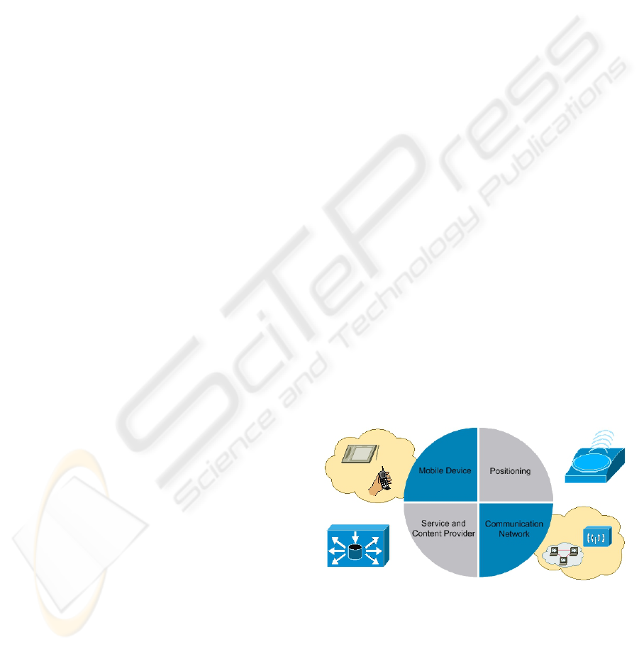
In Figure 1 the basic components and their
connections are shown:
Figure 1: Basic LBS Components.
• Mobile Devices: The terminal device that
presents the content to the end-user. Possible
devices are PDA's, Mobile Phones, Laptops.
• Communication Network: The IP Network,
used for exchange of data between the mobile
terminal and the service provider.
217
Zafeiropoulos A., Solidakis E., Zoi S., Konstantinou N., Stathopoulos P. and Mitrou N. (2007).
LOCATION BASED GUIDANCE SERVICES IN A MUSEUM ENVIRONMENT: DEPLOYMENT ISSUES AND A PROPOSED ARCHITECTURAL
APPROACH.
In Proceedings of the Second International Conference on Wireless Information Networks and Systems, pages 201-208
DOI: 10.5220/0002148402010208
Copyright
c
SciTePress
• Positioning Component: The Component used
for the selection of the suitable localization
technique.
• Service and Application Provider: The
service provider which offers a number of
different services to the user and is responsible
for the service request processing.
• Data and Content Provider: The Content
Management System that maintains all the
museum information which can be requested by
users.
In order to develop a platform to provide LBS,
the following requirements need to be fulfilled, as
described in (Sebastian Herden, Arman Mkrtchyan,
Claus Rautenstrauch, Andrι Zwanziger & Michael
Schenk, 2003): terminal independence, simple user
interface, minimal communication over mobile
telephone networks, integration of mobile devices,
simple integration of existing Internet services, high
availability of the services even at high loads,
scalability, openness (support common standards
and protocols), and low costs. Furthermore, in
(Carmine Ciavarella & Fabio Paterno, 2003) there
are analyzed the design criteria to use when
developing location-aware indoor mobile
applications. The most important of them are the
following: easy navigation through web browsers,
navigation feedback and minimal graphical
interaction, orientation support in the surrounding
environment and minimum redundancy in input
commands.
As far as the museum domain is concerned, the
term electronic-museum may include different
concepts, and corresponding technologies, which till
recently ranged mainly from “in museum” content
presentation (e.g. by exploiting virtual reality and
immersion technologies), to content publishing
through the museum’s web site. The evolution of
position tracking technologies and LBS has given
new possibilities of both indoor and outdoor context
aware guidance systems. Through such a context-
aware guidance system, the visitors in a museum can
receive location-based content immediately, even
through their own handheld devices (e.g. mobile
phones) in order to enhance visiting experience. In
this case, simple interfaces for content searching and
retrieval should be provided in order to appeal also
to users not familiar with technology (e.g. children)
and in order not to disrupt the user from focusing on
the exhibits themselves. Furthermore, any platform
arrangements (e.g. cables, servers, receivers) should
not distort the physiognomy of the museum. The
guidance system infrastructure should be easily
deployable to different exhibit topologies and
already existing content structures (e.g. Content
Management Systems).
Museum visitors can be classified to different
levels, first of all, according to their interests and
background, ranging from children and regular
visitors, to professionals and researchers. Each of
them demands a different level of knowledge and
detail. Furthermore, museum users can be classified
according to the terminal device they possess. For
example, laptop users may be able to get full
versions of the content (e.g. 3D models, detailed
maps), while small devices (e.g. smart phones or
Personal Digital Assistants) users may be able to
acquire a limited version of the content on-site, but
they may ask for an enhanced version for off line
usage (e.g. stored in a CD). In general, any guidance
system should be flexible as far it concerns serving
different classes of users.
Based on the above observations, we present a
lightweight approach for providing location aware
multimedia content retrieval, through Java enabled
handheld devices. The main distinguishing
characteristic of the proposed approach is that it
separates the positioning system from the content
access mechanisms, while being generic to the
selection of the radio localization technology. So far,
interfaces are provided for Bluetooth and Infrared
for indoor environments, as well as for GPS for
outdoor environments, while others can be
developed, e.g. RFID. Furthermore, it is built as an
open, standards-based, modular architecture
comprising a core of reusable components and
interfaces for supporting different types of services,
through web technologies.
A main characteristic of the proposed approach
is that it has minimum mobile device requirements,
since it operates in all java enabled mobile devices.
Therefore, only a Java middlet and a web browser
need to be installed in the mobile device, while, in
the backend what is required is an HTTP server and
Content Management System (CMS) which can be
determined independently. The components of the
proposed approach ensure modularity, in that
different types of services can be easily supported
for different groups of users. Finally, flexible
mechanisms, for adapting to most museums needs
are present, in regard to the physical platform,
computing and communication resources, to the site
configuration and set up and to the user equipment.
WINSYS 2007 - International Conference on Wireless Information Networks and Systems
218

2 LBS MECHANISMS AND
THEIR MUSEUM
APPLICATIONS
2.1 Position Tracking Technologies
The identification of a user’s position can be
performed at various levels of granularity: for
example, one is the identification of the exact user
position, thus, in a museum application, the system
can identify the closest work of art; another level is
when the system is only able to identify the room
where the user is located.
Position tracking technologies aim to measure
the movement of the mobile terminal. These
technologies provide great accuracy, but are limited
in terms of geographic coverage. To explicitly
localize the users in indoor applications, three recent
technologies are mainly exploited: WLAN,
Bluetooth and Infrared. In (Carmine Ciavarella &
Fabio Paterno, 2003) advantages and disadvantages
of each of them are highlighted. In the next
paragraph we provide an overview of these
technologies.
WLAN technology allows devices to
immediately connect to a LAN. As stated in
(Carmine Ciavarella & Fabio Paterno, 2003), to
locate the position of the users in a building, WLAN
is not a so simple solution, because the system has to
apply triangulation methods to the data coming from
at least three access points near the user. Installation
of many wireless access points will cause a negative
effect in a museum environment. In addition, the
developers have to devote a great deal of attention to
prevent ambiguous situations on the borders of the
intersections of the covered areas.
Bluetooth technology is an ad hoc technology
that requires no fixed infrastructure and is simple to
install and set up. A fundamental Bluetooth wireless
technology strength is the ability to simultaneously
handle both data and voice transmissions with low
power. It is designed to be small and to keep costs
low to be included in practically any device. Above
all, it has great ability to locate neighbour devices
and discover the type of services they could offer.
These properties make applications easier to use for
the end user, and also reduce maintenance costs,
characteristics which render Bluetooth suitable for
indoor environments.
IrDA protocol of communication supports high
data rates and requires line-of-sight contact. But
infrared has some drawbacks. Firstly, it rebounds
over the surfaces and secondly requires that sender
and receiver are aligned. IrDA is a point-to-point,
narrow angle (30° cone), ad-hoc data transmission
standard designed to operate over a distance of 0 to
1 meter. These limitations make IrDA not user-
friendly for e-guidance applications.
GSM LBS provide personalized services to the
subscriber based on their current position. But,
cellular positioning technologies are an opportunistic
development rather the original purpose of cellular
networks and consequently cellular technologies are
less accurate (J. Ranchordas & A. Lenanghan,
2003). Furthermore, GSM technologies add extra
cost to the end-user and discourage him from using
the application.
Finally, GPS is used from the majority of LBS
systems for outdoor tracking environments. The
position calculated by a GPS receiver requires the
current time, the position of the satellite and the
measured delay of the received signal. The position
accuracy is primarily dependent on the satellite
position and signal delay.
2.2 Localization Systems for Museum
Environments
Many localization and navigational based
mechanisms and frameworks are available in
museums nowadays, aiming to provide indoor and
outdoor LBS to end users. Their main disadvantages
are that they are tightly coupled to the localization
technology, user device, and content access
mechanisms and technologies. Thus, specialized
hardware and software capabilities are needed to
exploit them. Finally, human interaction is needed
most times not only to install them but also to
support them during their operation.
CMUseum provides location-aware video
streaming services with other add-on features which
enable automatic tour guidance without user
intervention. This design requires specialized
hardware, as it incorporates an 802.15.4 Zigbee
sensor network for collecting information as well as
an 802.11 Wi-Fi network for streaming video
contents. Yo-Ping Huang and Wei-Po Chuang
propose a pull-based approach guide system that
combines the positioning technique and location-
awareness service to provide the surrounding
information for users. The guide system not only
accepts the user’s search query to find the target but
also receives the information from other users who
took notes during the tour guide (Yo-Ping Huang
and Wei-Po, 2004).
Musex (Koji Yatani, Masanori Sugimoto &
Fusako Kusunoki, 2004) is also implemented to
LOCATION BASED GUIDANCE SERVICES IN A MUSEUM ENVIRONMENT: DEPLOYMENT ISSUES AND A
PROPOSED ARCHITECTURAL APPROACH
219

support children’s learning in a museum with use of
RFID for localization and a tour guide system which
is built for understanding how pervasive computing
can support a museum-like experience. The
Hippie/HIPS project (R. Oppermann & M. Specht,
2000) concerns the development of an exhibition
guide, which provides guidance and information
services. The guide senses infrared beacons installed
near all exhibits. From these observations about the
visitor’s journey through the exhibition the system
creates a user profile and suggests interesting
exhibits augmenting them with background
information. The limitation of this approach is that
often the user's position alone is not enough to
indicate interest in the closest work of art. Thus, the
risk is that the system erroneously identifies the user
interests and determines the corresponding user
model.
According to (Christian Kray & Jorg Baus,
2005), in terms of positioning, roughly half of the
systems rely on GPS while a large group of them use
infrared beacons. Furthermore, about half of the
systems include some means of interacting with the
user to determine his position. As far as the
architecture is concerned, some systems are based
on the client-server paradigm while others are built
using interactive applications. The first have the
advantage that, given a reliable connection between
client and server, they allow easy adoption of
multiple clients. The later offer a more decentralized
approach, but they may depend on a certain
device/platform.
In (Y. Wang & all, 2004), among others,
advanced wireless services are provided in the
International Airport based on GPS and WLAN
technologies, on a distributed, agent-based
architecture. Also, in (P. Kalliaras & all, 2004), an
ambient information system allowing GPS based,
location-aware, interactive guidance is presented. In
this system, a guidance session includes complex
content retrieval composed of geographical,
historical and geological information and can be
realized both on-site through handheld devices, and
through the Internet and TV channels. System
architecture is built based on the client-server
paradigm and Web technologies, with the focus
being on serving multiple communication channels
through a common content server. Based on the
experience acquired from the above frameworks, we
present a lightweight approach for providing
Location Based Content Retrieval in order to support
different e-Museum guidance services.
3 THE PROPOSED
ARCHITECTURAL APPROACH
FOR LOCATION-BASED
MUSEUM GUIDANCE
In this section a proposed architectural approach for
providing web-based location based multimedia
content retrieval through Java enabled devices is
presented. In order to avoid system lock-in and to
reduce development costs our approach is based on
open standards and open source components, where
possible. Furthermore, independence from the
underlying hardware and software, by selecting
generic widespread approaches, is provided.
The main advantage of the proposed approach, in
comparison with the implementations reported in
previous sections, is first of all, that the various
system components are designed and implemented
in a modular manner in order to select the most
appropriate in each specific installation. This
modularity regards:
• The separation of the positioning system from
the content access mechanisms.
• The selection of the localization radio
mechanism, accordingly with the
implementation site.
• The selection of the terminal mobile device. The
only requirement for the mobile device is to be
Java enabled, something very common in the
majority of the new generation mobile phones,
PDAs e.t.c. The content is being presented to
the device through any available web browser.
• Independence from the underlying hardware
infrastructure. The entire system is based on
Web technologies, which can be deployed
easily in any server.
• Independence from the content being available
to the end-user. All the content is available
through the content management server, and can
be renewed dynamically without any change
and any intervention to our system.
In addition, the entire process is transparent to
the user. In opposition with other LBS frameworks,
no input is requested from the end-user. He just
receives the appropriate content in his display, in
correspondence with his position. The system is
designed so that all the amount of data is transferred
through the local communication infrastructure.
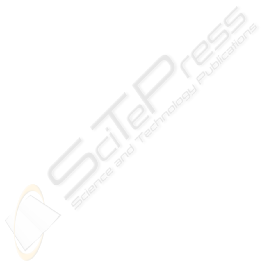
3.1 Overall Architecture
In this section, we describe the core elements of the
proposed system architecture. The different
WINSYS 2007 - International Conference on Wireless Information Networks and Systems
220
components of our approach are the end-user
terminals, the backend platform components and the
communication infrastructure. The core elements of
the proposed system architecture and the way they
are connected are shown in Figure 2.
Figure 2: Core System Elements.
The main characteristics of these components are the
following:
• Localization technologies such as Bluetooth,
Infrared or GPS. These can be integrated to the
user device or provided as a separate hardware
module.
• The communication network, which can be any IP
enabled access network, e.g. a WLAN network,
GPRS or 3G network.
• The Terminal Module, that runs on the mobile
device. This is essentially a J2ME middlet which
implements the generic localization approach,
enables location tracking by using the terminal
localization device interfaces, and communicates
with the server-side component, which translates
physical location to content URI. It also provides
the appropriate Graphical User Interfaces.
• The localization server for providing association
between location information given by the user
terminal and a specific point of interest. The
association can be performed independently of the
localization mechanism selected - the content is
completely orthogonal to the localization
mechanism and can be renewed easily. This kind
of association is URI-based, because each point of
interest corresponds to a specific content URI in
the server.
• The content related to each point of interest which
becomes automatically available to the user
terminal by the content management system
(CMS), through the IP access network.
The redirection mechanism, which is based on
AJAX technologies (Jesse Garrett, 2005). As far as
the terminal-side is concerned it has to support
JavaScript. Otherwise, the redirection is
implemented through periodic HTTP refreshes to the
server-side.
3.2 System Components
3.2.1 Mobile Device Software – Terminal
Module
In order to search and select the desired point of
interest, we have developed a Java middlet that can
be installed easily in any mobile device that supports
Connected Limited Device Configuration - CLDC
and Mobile Information Device Profile - MIDP of
Java Platform Micro Edition - J2ME.
There is a configuration menu in the start form of
the middlet, where each user can select language,
audio and video options and complexity level for the
application. In case of indoor environments, the end-
user performs initially a search for localization
interest points -that exist within the scope of the
terminal- and the ID's of all the detected interest
points are returned. Otherwise, in case of tracking
technologies that are based on user coordinates (e.g.
GPS), the localization mechanism sends an exact
geographic coordinate instead of the ID. An extra
module is implemented in the server which converts
specific coordinates to unique IDs of points of
interest. All this information is transmitted through
the IP access network and is stored in the
localization database.
3.2.2 The Location to URI Database –
Localization Server
The database of the entire system is set-up on the
server. The database holds information about the
points of interest, the devices that executed the
application and information regarding the
association between them. Extra data are also saved,
correlating each point of interest with a URI, which
leads to the specific content for this point of interest.
Each time the Java middlet is started, the database is
updated with the new information sent from the
mobile device.
Every location corresponds to a URI at the CMS
server, as described earlier, – featuring some content
– static or dynamically generated. Almost
everything is controlled from the server, increasing a
lot the easiness of use for the end-user. Changes in
LOCATION BASED GUIDANCE SERVICES IN A MUSEUM ENVIRONMENT: DEPLOYMENT ISSUES AND A
PROPOSED ARCHITECTURAL APPROACH
221
the content don’t affect our application, rendering it
content independent.
We have defined various actors for different users in
our database scheme. The knowledge level and the
level of specialisation of every user are stored.
Different URIs are saved according to the native
language, the skills and the experience of the end-
users.
3.2.3 The Redirection Mechanism
After the initial installation of the middlet on the
end-users terminals, their browsers point to the web-
pages describing the corresponding nearest point of
interest. Ajax technology is used in order for the
terminals to remain active, waiting for the middlet to
update the database with the next point of interest.
As soon as the middlet inserts a new entry in the
database, new content is pushed to the browser by
the use of Ajax. The web-page is refreshed
asynchronously pointing to URI of the new point of
interest. In this way the web pages do not have to be
reloaded periodically. This is done only in case
where the terminal device does nοt support
JavaScript. The intent is to make web pages more
responsive by exchanging small amounts of data
with the server behind the scenes, so that the entire
web page does not have to be reloaded each time the
user requests a change. This is meant to increase the
web page's interactivity, speed, and usability.
3.3 Demonstration - Museum
Implementation
A museum e-guidance system application has been
developed in the scope of the E-Museum project
(*)
that utilizes Bluetooth localization technology for
the positioning of the museum exhibits and WLAN
technology for the IP network communication.
Content management functions are built based on an
existing CMS, as well as on e-museum specific
extensions. The open source Joomla CMS has been
selected. In addition, we have developed special
templates for mobile devices with the use of the Xe-
Media Mobile Template for Joomla. In each request,
the server checks the browser that makes the request
and accordingly returns the page in the appropriate
template.
As far as the implementation is concerned, we
chose to use a Nokia E61 smart phone with Symbian
OS, a 3COM 802.11g WLAN access point, 3
Bluetooth access points with power management
(class 1, 2 and 3) and a Linux HTTP and MySQL
Database Server. The development of this middlet
has been accomplished with Netbeans IDE 5.5
extended with the Mobility Pack for CLDC/MIDP,
while the simulations were implemented with Sun
Java Wireless Toolkit for CLDC 2.5.
The E-museum system overview is shown in Figure
3.
Figure 3: E-museum System Overview.
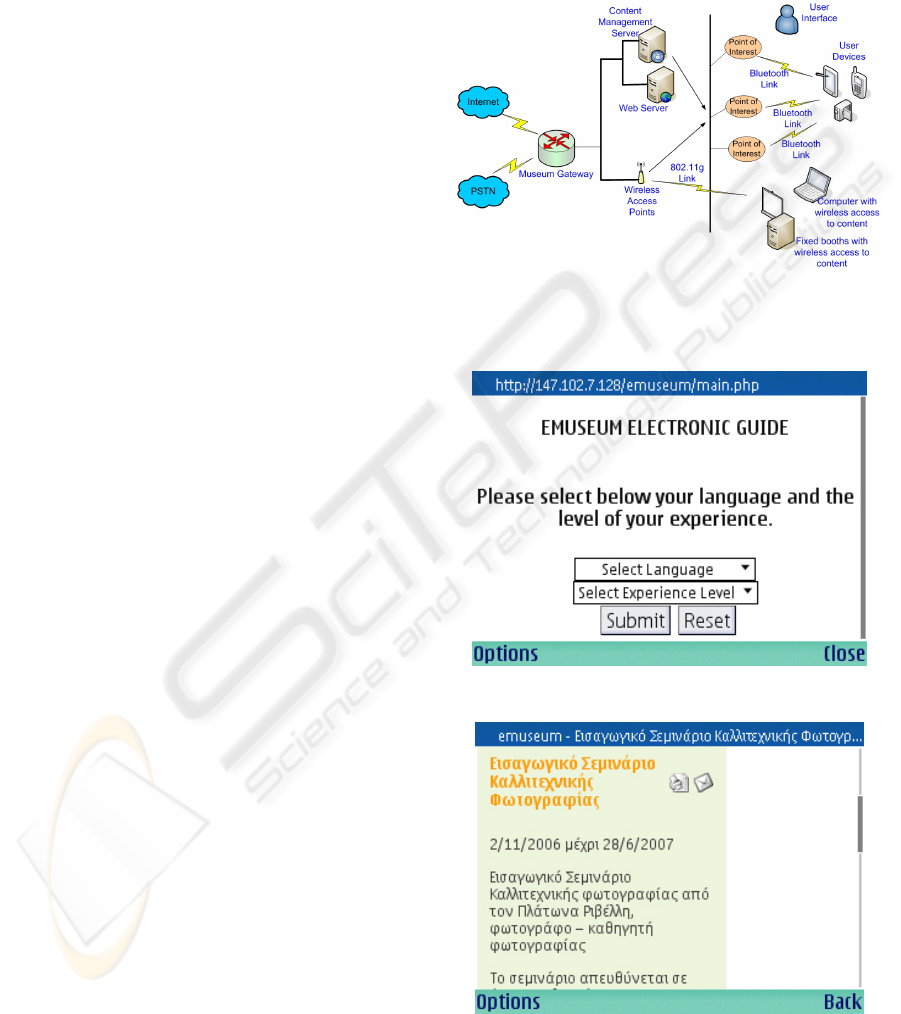
Screenshots from the mobile device used are shown
in Figures 4 and 5.
Figure 4: E-museum Screenshot.
Figure 5: E-museum Screenshot.
WINSYS 2007 - International Conference on Wireless Information Networks and Systems
222
4 SERVICES OFFERED AND
OPERATION SCENARIO
In this section we describe the services that our
system offers to museum visitors. We support a wide
range of services targeted to the needs of different
user requirements. The most important of them are
the following:
1. Automatic (push) content retrieval based on
visitor proximity to an exhibit or group of
exhibits: The handheld device that the user
carries identifies his location in relation with a
certain exhibit or group of exhibits, through a
suitable positioning technology. After location
identification, a request for audiovisual content
related with a certain exhibit (or group of
exhibits) is created automatically.
2. On demand (pull) content retrieval: This service
is enabled via the E-Museum wireless
communication infrastructure and it addresses
more experienced users. Context aware
information, related with the user’s position, is
used to help him to browse the E-Museum’s
collections and/or to create more targeted search
queries.
3. Directional information (e.g. vector maps),
indicating the user’s current location in the
museum and how he can move throughout the
museum, can be offered to the user terminal
after request. The next desirable point of interest
can also be specified. In this occasion, a graphic
interface showing the most efficient route to
that spot is displayed instantaneously. In
addition, a traffic assistant can show the
snapshot of the current traffic flow in the
museum. This feature enables the visitor to
avoid big crowd in his tour.
4. Creation of live linear guidance: User provides
his profile and preferences (e.g. concerning a
certain historical period that wants to examine)
and the system automatically creates linear
guidance including only the exhibits of interest
and excluding exhibits that are not of interest to
the user. Guidance and location information is
also provided in this service.
5. Registration of path and content of interest for
offline usage: Users with handheld devices may
be able to get only a small subset of the content
while on-site, due to limitations in the
processing power of their devices. However, the
path with exhibits of interest is registered and
presentations with full versions of content are
created for offline usage (e.g. stored in CDs that
the user buys after the visit to the museum).
In the following section we describe the simple
steps that a user has to follow in order to access the
application.
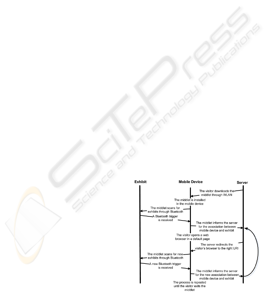
1. The user downloads the middlet from the IP
network and installs it in his mobile device.
2. Then, his mobile device scans repeatedly, in a
defined time space, for points of interest
through the Bluetooth SDP.
3. Every time the middlet scans a new point of
interest, it communicates with the server and
informs it about the new data. The
communication is done via HTTP POST
messages.
4. The server holds information about the nearest
point of interest at which each user is every
moment and consequently sends to the terminal
device all the related content.
5. The user needs only to open a web browser to
his terminal device in a default page and,
through the redirection mechanism he will be
redirected to the page with the content of the
selected point of interest.
6. Each time a new localization trigger is received,
the user will be redirected to the content of the
new point of interest.
Special attention has to be given on the right
placement of the points of interest. In case of
redundant points that need to be identified within a
limited space, only one localization interface is
installed. The corresponding web page with this
interface is displayed on the user terminal display,
with multiple thumbnail images for the points of
interest, to allow the user to select the desired web
page. By this procedure, the offered application is
reliable in all cases.
All the above user steps are shown in Figure 6.
Figure 6: Operation Scenario.
LOCATION BASED GUIDANCE SERVICES IN A MUSEUM ENVIRONMENT: DEPLOYMENT ISSUES AND A
PROPOSED ARCHITECTURAL APPROACH
223

5 CONCLUSIONS & FURTHER
WORK
Based on the assumptions that it is desired to allow a
museum guidance system to dynamically select
localization technology, the appropriate software
and hardware for the backend platform, as well as
the terminal mobile device, we have argued that
a
comprehensive solution for museum location-based
guidance services should address the challenges of
modularity and openness. We therefore proposed an
approach for providing Location Based Guidance
Services that attempts to address these issues, while
we described an architectural framework for
enabling such
a system. The application of the
framework has been evaluated in a prototype e-
museum guidance system, highlighting some of the
issues involved in the use of location-based services.
Future work will include the support of user-
transparent handover process aiming at the selection
of the most suitable localization technique, in
heterogeneous environments (e.g. indoor-outdoor).
Experimental work is currently underway towards
evaluating the behaviour of the different localization
techniques in several, environments.
ACKNOWLEDGEMENTS
Parts of the work presented are funded by the
Semantix SA in the framework of the GSRT
PAVET-NE research and development action. The
authors of this paper would like to thank their
colleagues in Semantix S.A.
(http://www.semantix.gr) for their contribution and
cooperation.
REFERENCES
Carmine Ciavarella & Fabio Paterno , “Design Criteria
for Location-aware, Indoor, PDA applications”,
Proceedings of Fifth International Symposium on
Human Computer Interaction with Mobile Devices
and Services, Udine, Italy, 2003, επ. L. Chittaro,
Lecture Notes in Computer Science, Vol. 2795, 131-
144. Berlin: Springer-Verlag.
Sebastian Herden, Arman Mkrtchyan, Claus
Rautenstrauch, Andrι Zwanziger & Michael Schenk,
“Personal Information Guide – A Platform with
Location Based Services for Mobile Powered E-
commerce”, DEXA 2003.
Yo-Ping Huang & Wei-Po Chuang, “Improving the
Museum’s Service by Data Mining and Location-
aware Approach”, 2004 IEEE lntemational Conference
on Systems, Man and Cybemetics.
Tsung-Yu Liu, Tan-Hsu Tan & Yu-Ling Chu2, “The
Ubiquitous Museum Learning Environment: Concept,
Design, Implementation, and a Case Study”,
Proceedings of the Sixth International Conference on
Advanced Learning Technologies (ICALT'06).
Stefan Steiniger, Moritz Neun & Alistair Edwardes,
“Foundations of Location Based Services”,
http://www.geo.unizh.ch/publications/cartouche/lbs_le
cturenotes_steinigeretal2006.pdf , 2006.
Sebastian Herden, Arman Mkrtchyan, Claus
Rautenstrauch, Andrι Zwanziger & Michael Schenk,
“Personal Information Guide – A Platform with
Location Based Services for Mobile Powered E-
commerce”, DEXA 2003.
R. Oppermann & M. Specht. “A Context-Sensitive
Nomadic Exhibition Guide”. In Second Symposium
on Handheld and Ubiquitous Computing - HUC2K,
pages 127–149, Berlin, 2000. Springer.
IST SCALEX Project - http://www.scalex.info/.
Christian Kray & Jorg Baus, “A Survey of Mobile
Guides”, ICPWC 2005.
Y. Wang, L. Cuthbert, Francis J. Mullany, P.
Stathopoulos, V. Tountopoulos & M. Senis,
"Exploring Agent-based Wireless Business Models
and Decision Support Applications in an Airport
Environment", Journal of Telecommunications and
Information Technology, no. 3/2004.
P. Kalliaras, A. D. Sotiriou, S. Zoi, P. Papageorgiou, J. N.
Karigiannis, N. Farantouris & N. Mitrou “The Avaton
Architecture: Location-Based Multimedia Services For
Tourists” in ITI 2nd International Conference on
Information & Communication Technology (ICICT
2004) 6, 7 December 2004, Cairo – EGYPT.
Koji Yatani, Masanori Sugimoto & Fusako Kusunoki,
“Musex: A System for Supporting Children’s
Collaborative Learning in a Museum with PDAs”,
Proceedings of the The 2nd IEEE International
Workshop on Wireless and Mobile Technologies in
Education (WMTE’04).
Luyten, K. & Coninx, K. ImogI: Take Control over a
Context Aware Electronic Mobile Guide for
Museums. HCI in Mobile Guides, 13 September 2004,
University of Strathclyde, Glasgow.
C. Floerkemeier & M. Lampe. Issues with RFID Usage in
Ubiquitious Computing Applications. In Pervasive
Computing, pages 188–193, 2004.
J. Ranchordas & A. Lenanghan, “A Flexible Framework
for using Positioning Technologies in Location-
Based Services”, EUROCON 2003
Jesse Garrett, “Ajax: A New Approach to Web
Applications”,
http://www.adaptivepath.com/publications/essays/arch
ives/000385.php, 2005.
WINSYS 2007 - International Conference on Wireless Information Networks and Systems
224
