
A DATA WAREHOUSE ARCHITECTURE FOR INTEGRATING
FIELD-BASED DATA
Alberto Salguero, Francisco Araque and Ramón Carrasco
Dpt. LSI – ETSII, University of Granada (Andalucía), España
Keywords: Spatial Data Warehouse, extraction, field-based data.
Abstract: Spatial DataWarehouses (SDWs) combine DWs and Spatial Data Bases (SDBs) for managing significant
amounts of historical data that include spatial location. Some spatial information can be seen as a
continuous field, and the information of interest is obtained at each point of a space. The previously
proposed extensions of the multidimensional data model, used in Data Warehousing, only deal with spatial
objects. None of them consider field-based information. This paper presents a Data Warehouse architecture
that automatically determines the best parameters for refreshing and integrating field-based data from
different data sources.
1 INTRODUCTION
Spatial Data Bases (SDB) have a long experience in
managing spatial data, and there is extensive
research referring to spatial index structures, storage
management, and dynamic query formulation. In
order to manipulate spatial objects, a SDB must
include special data types to represent geometric
characteristics of objects. On the other hand, space
also can be seen as a continuous field, and the
information of interest, temperature, pressure,
elevation…, is obtained at each point of the space.
Geographic Information Systems (GIS) are the
obvious potential candidates for such tasks. While
having some spatio-temporal analytical capabilities,
it is recognized that existing GISs per se are not
adequate for decision-support applications when
used alone (Bédard et al., 2001). Among the possible
solutions, the coupling of spatial and non-spatial
technologies, GIS and OnLine Analytical Processing
(OLAP) for instance, may be an interesting option.
OLAP systems are usually implemented through
Data Warehouses (DWs). A Spatial Data Warehouse
(SDW) combines DWs and Spatial Data Bases for
managing significant amounts of historical data that
include spatial location.
Inmon (Inmon, 2002) defined a DW as “a
subject-oriented, integrated, time-variant, non-
volatile collection of data in support of
management’s decision-making process.” A DW is a
database that stores a copy of operational data with
an optimized structure for query and analysis. In
terms of a more limited scope, a new concept is
defined: a Data Mart (DM) is a highly focused DW
covering a single department or subject area.
The generic architecture of a DW is illustrated in
Figure 1. It can be seen that data sources include
existing operational databases and flat files (i.e.,
spreadsheets or text files) in combination with
external databases. The data are extracted from the
sources and then loaded into the DW using various
data loaders and other tools (Araque and Samos,
2003). The warehouse is then used to populate the
various subject (or process) oriented data marts and
OLAP servers. Data marts are subsets of a DW
categorized according to functional areas depending
on the domain (problem area being addressed) and
OLAP servers are software tools that help a user to
prepare data for analysis, query processing,
reporting and data mining.
DB
Files
Data Warehouse
Data Marts
Analysis
Extract
Transform
Load
Load Serve
Figure 1: A generic DW architecture.
DWs are usually based on a multidimensional
data model to make easy the querying and the
analysis of the data. Several extensions of the
577
Salguero A., Araque F. and Carrasco R. (2007).
A DATA WAREHOUSE ARCHITECTURE FOR INTEGRATING FIELD-BASED DATA.
In Proceedings of the Ninth International Conference on Enterprise Information Systems - DISI, pages 577-580
DOI: 10.5220/0002391105770580
Copyright
c
SciTePress

multidimensional data model that consider the
spatial aspects of data have been proposed last years.
These works usually incorporate the concepts of
SDBs to the multidimensional data model (Bimonte
et al., 2005), (Malinowski and Zimányi, 2004),
(Gascueña et al., 2006). These models focus on the
representation of complex spatial objects (SO). None
of the reviewed models deal with field-based
information. The addition of this kind of information
to the conceptual data model is not a difficult task.
The main problem is that the data should be obtained
from autonomous data sources. Usually, the field-
based information is created by interpolating the
values of several sensors distributed along a surface.
In Data Warehousing it is necessary to integrate this
semantically-related data from several data sources.
Furthermore, when the information refers to the
same spatial location it can be consider information
semantically equivalent. It is possible that two data
sources refer to the same real-world entity at the
same time with different spatial or temporal detail.
This paper presents an architecture that
automatically determines the best parameters for
refreshing and integrating field-based data from
different data sources.
The remainder of this paper is organized as
follows. In section 2 our architecture for integrating
spatial data is presented; in section 3 an illustrative
example is explained; finally, section 4 summarizes
the conclusions of this paper and discusses future
work.
2 ARCHITECTURE
The architecture described here can determine the
best parameters for refreshing data sources which
contain spatial data semantically related. If we use a
set of sensors distributed along a surface, for
instance, to know the temperature at each point of
that surface (interpolating), we need to know the
values of all sensors at a given instant in order to
make comparable captures of field-based data.
Taking paper (Sheth and Larson, 1990) as point
of departure, we propose the following reference
architecture. Three more different levels should be
considered:
Component Scheme ST: the conversion of a
Native Scheme to our Canonical Data Model
(CDM), enriched so that temporal and spatial
concepts could be expressed.
Exportation Scheme ST: it represents the part of
a component scheme which is available for the
DW designer. It is expressed in the same CDM
as the Component Scheme.
Data Warehouse Scheme: it corresponds to the
integration of multiple Exportation Schemes ST
according to the design needs expressed in an
enriched CDM so that temporal concepts could
be expressed
We will describe now the functional architecture
in a detailed way.
Native Schema. Initially we have the different
data source schemes expressed in its native schemes.
Each data source will have, a scheme, the data
inherent to the source and the metadata of its
scheme. In the metadata we will have huge
temporal and spatial information about the source:
temporal and spatial data on the scheme, metadata
on availability of the source…
The temporal parameters we consider of interest
for the integration process are (Araque et al., 2006a):
Availability Window (AW). Period of time in
which the data source can be accessed.
Extraction Time (ET). Period of time taken by
the monitoring program to extract significant
data from the source.
Granularity (Gr). It is the extent to which a
system contains discrete components of ever-
smaller size. In our case it is common to deal
with granules like meter, kilometre…
To solve the problem of getting this information
from Web accessible sources, we present tools to
define and generate wrappers. We define a wrapper
interface to specify the capability of Web Sources
and extend a wrapper generation toolkit. We use
DETC (Data Extraction with Temporal Constraints)
to refer to the software tool.
Preintegration. In the Preintegration phase, the
semantic enrichment of the data source native
schemes is made by the conversion processor. In
addition, the data source spatial and temporal
metadata are used to enrich the data source scheme
with temporal properties. We obtain the component
scheme (CS) expressed in the CDM, in our case,
ODMG-ST (ODMG enriched with spatial and
temporal elements).
Componet and Export Schemas. From the CS
expressed in ODMG-ST, the negotiation processor
generates the export schemes (ES) expressed in
ODMG-ST. These ES are the part of the CS that is
considered necessary for its integration in the DW.
For privacy reasons part of the CS can be hidden.
Integration. From many data sources ES, the
DW scheme is constructed (expressed in ODMG-
ST). This process is made by the Integration
Processor that suggests how to integrate the Export
ICEIS 2007 - International Conference on Enterprise Information Systems
578

Schemes helping to solve semantic heterogeneities
(out of the scope of this paper). In the definition of
the DW scheme, the DW Administrator participates
in order to contemplate the characteristics of
structuring and storage of the data in the DW.
Three modules have been added to the reference
architecture in order to carry out the integration of
the data, considering the data extraction method
used:
- The Temporal Integration Processor uses the
set of semantic relations and the conformed schemes
obtained during the detection phase of similarities.
As a result, we obtain data in form of rules about the
integration possibilities existing between the
originating data from the data sources (minimum
granularity...). This information is kept in the
Temporal Metadata Warehouse. In addition, as a
result of the Temporal Integration process, a set of
mapping functions is obtained.
- The Spatial Integration Processor does the
necessary transformations of the spatial data in data
sources in order to integrate them. It is necessary to
convert all of data to the same format and unit of
measurement. It is also responsible of dealing with
the different spatial granularity of data we can find
in different data sources.
- The Metadata Refreshment Generator
determines the most suitable parameters to carry out
the refreshment of data in the DW scheme. The DW
scheme is generated in the resolution phase of the
methodology of integration of schemes of data. It is
in this second phase where, from the minimum
requirements generated by the temporal integration
and stored in the Temporal Metadata warehouse, the
DW designer fixes the refreshment parameters. As
result, the DW scheme is obtained along with the
Refreshment Metadata necessary to update the
former according to the data extraction method and
other temporal properties of a concrete data source.
Data Warehouse Refreshment. After temporal
integration and once the DW scheme is obtained, its
maintenance and update will be necessary. This
function is carried out by the DW Refreshment
Processor. Taking both the minimum requirements
that are due to fulfill the requirements to carry out
integration between two data of different data
sources (obtained by means of the Temporal
Integration module) and the integrated scheme
(obtained by the resolution module) the refreshment
parameters of the data stored in the DW will be
adjusted.
3 EXAMPLE
A Decision Support System (DSS) being based on a
DW is presented as an example (fig. 2). This can be
offered by Small and Medium-Sized Enterprises
(SMEs) as a plus for adventure tourism. Here, a DSS
is used to assist novel and expert pilots in the
decision-making process for a soaring trip (Araque
et al., 2006b). These pilots depend to a large extent
on meteorological conditions to carry out their
activity and an important part of the system is
responsible for handling this information. Two web
data sources are mainly used to obtain this kind of
information:
The US National Weather Service Website. We
can access weather measurements (temperature,
pressure, humidity, etc) in every airport in the
world. In Spain we can find 48 airports where
we can extract this information.
In order to obtain a more detailed analysis and to
select the best zone to fly, pilots can access to
the Spanish National Weather Institute (INM)
website. There are 205 meteorological stations
distributed along the Spanish surface. They are
usually refreshed every thirty minutes.
The continuous integration of Web data sources
may result in a collapse of the resources of the
SMEs, which are not designed to support the
laborious task of maintaining a DW up to date.
In our approach, the DW administrator
introduces the data sources temporal properties in
DETC tool and selects the parameters to integrate,
for example the temperature. This tool is able to
determine the maximum level of detail (granularity).
We find out that in the second source, the
information about the temperature can be precise
with a detail of “minute” (for example, that at 14
hours and 30 minutes there were a temperature of
15ºC), whereas in the first case it talks about the
temperature with a detail of “hour” (for example,
that at 14 hours there were 15ºC).
It can also determine the time intervals in which
this information is available to be queried (useful
when dealing with other kind of data sources).
Applying the temporal algorithms, out of the
scope of this paper, we would obtain all possible
instants of querying which both sources are
accessible at, so the extraction and integration
process can be performed (Araque et al., 2006a).
Let us suppose that both data sources in this
example are always available for querying. The
DWA, who usually wants to get the most detailed
information, would select to extract the changes
from the first data source every hour and every half
an hour in the case of the second one. There is a
waste of resources in this approach.
A DATA WAREHOUSE ARCHITECTURE FOR INTEGRATING FIELD-BASED DATA
579
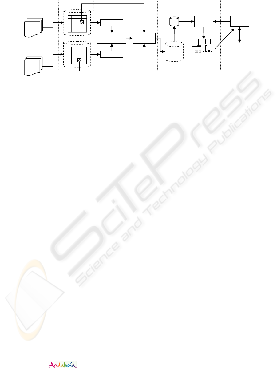
DW
DM
DSS Tools
Online reservation
system
End user
DETC
Spatial/temporal
integrator
Travel
agency
Report
Generator
Reports
US National Weather
Service Website
Spanish National Weather
Institute website
DETC
Refreshment
processor
NATIVE
SCHEMAS
COMPONENT/
EXPORT
SCHEMAS
INTEGRATION
& DW
PROCESSOR
DW / DM
SCHEMAS
Figure 2:
Illustrative example.
The field-based data distribution obtained using only
the second data source (every thirty minutes) is not
always comparable with the data distribution
obtained combining both data sources because
almost 20% of the sensors are unavailable (airports
sensors are refreshed every hour). Therefore, if we
cannot make use of the information obtained from
the second data source for analysis when there are
not values to get from the first one, we are actually
discarding about 205/(205+205+48) = 45% of
extracting, transforming and loading processes.
The architecture presented in this work is able to
detect this kind of issues and determine that it has no
sense to query the second data source every thirty
minutes.
4 CONCLUSIONS
Several extensions of the multidimensional data
model, which is mainly used in Data Warehousing,
that consider the spatial aspects of data have been
proposed. The problem is that in Data Warehousing
it is necessary to integrate data from several data
sources. This issue has not been widely studied,
especially in the case of field-based data. In Data
Warehousing, the integration of this kind of data
requires all values of sensors to be accessible in
order to compare the results.
This paper presents a Data Warehouse
architecture that automatically determines the best
parameters for refreshing and integrating field-based
data from different data sources.
This work has been supported by the Spanish
Research Program under project TIN2005-09098-
C05-03 and the by
Research Program
under project 2006/282916.
REFERENCES
Araque, F., Salguero, A., Abad, M.M., 2006b. Application
of data warehouse and Decision Support System in
Soaring site recommendation. Proc. Information and
Communication Technologies in Tourism, ENTER.
Springer Verlag, Lausanne, Switzerland.
Araque, F., Salguero, A.G., Delgado, C., Garvi, E., Samos,
J., 2006a. Algorithms for integrating temporal
properties of data in Data Warehouse. 8th International
Conference on Enterprise Information Systems
(ICEIS). Paphos, Cyprus.
Araque, F., Samos, J., 2003. Data warehouse refreshment
maintaining temporal consistency. 5th Intern.
Conference on Enterprise Information Systems,
ICEIS. Angers. France.
Bédard, Y., T. Merrett and J. Han. 2001. Fundamentals of
spatial data warehousing for geographic knowledge
discovery. Geographic Data Mining and Knowledge
Discovery. Ed. H. Miller & J. Han, Taylor & Francis.
Bimonte, S., Tchounikine, A., Miquel, M., 2005. Towards
a Spatial Multidimensional Model , DOLAP05, ACM
Eighth International Workshop on Data Warehousing
and OLAP , Bremen, Germany.
Gascueña, C. M., Cuadra, C., Martínez, P. A., 2006.
Multidimensional approach to the representation of the
spatio-temporal multi-granularity. In proceedings of
the Intern. Conference on Enterprise Information
Systems (ICEIS). Paphos, Cyprus.
Inmon, W.H., 2002. Building the Data Warehouse. John
Wiley.
Malinowski, E., Zimányi, E., 2004. Representing spatiality
in a conceptual multidimensional model. In
proceedings of the 12th annual ACM International
workshop on Geographic information systems.
Washington DC, New York, USA.
Sheth, A., Larson, J., 1990. Federated Database Systems
for Managing Distributed, Heterogeneous and
Autonomous Databases. ACM Computing Surveys,
Vol. 22, No. 3
ICEIS 2007 - International Conference on Enterprise Information Systems
580
