
FINDING THE WAY: SERVICES FOR A MULTI-VIEW AND
MULTI-PLATFORM GEOGRAPHIC INFORMATION SYSTEM
Sergio Martín, Elio Sancristobal, Rosario Gil
Electrical and Computer Dep., UNED (Spanish University for Distance Education), Juan del Rosal 12, Madrid, Spain
Gabriel Díaz, Nuria Oliva, Manuel Castro, Juan Peire
Electrical and Computer Dep., UNED (Spanish University for Distance Education), Juan del Rosal 12, Madrid, Spain
Keywords: Mobility, GIS, GPS, web mapping.
Abstract: Geographic information systems are getting more importance in the last years, especially in organizations
where it is important to find an easy way to get to some place. The present paper describes the development
carried out in order to make easier the business in organizations with high mobility requirements. The main
result of this development is a system that generates several views of the geographic information of an
organization in real time. The first view is a web information system that shows graphically all the points on
a map, giving multimedia information. It allows interacting with all of them, creating the most suitable
routes from one to another, finding hotel, restaurants, etc near the centre. On the other hand, the system also
provides information of the points of interest through the main commercial GPS navigators.
1 INTRODUCTION
Mobility has become a fundamental element inside
organizations in the last years. Nowadays, most of
them are working to enhance it by improving the
geographic information services offered to both stuff
and customers.
It takes a special relevance in the case of delivery
or transport companies, where the knowledge of the
customer’s locations and the routes to them play a
crucial role inside the business.
In general, geographic information systems
obtain usefulness in any kind of organizations where
it is important to find an easy way to get to some
place (Boonthuma, 2007).
The aim of the present paper is to describe a
system that will show different views of the
geographical information of an organization. For
that task, the system will retrieve from a MS Word
document all the names and addresses of the points
of interest of the organization, and it will show them
in 3 different ways: on Google Maps, on Google
Earth and on the most popular GPS navigators.
2 THE PROBLEM
One environment where mobility services find a
relevant role is at universities with a very wide and
spread campus. This is the case of universities for
distance education or open universities (Castro,
2006).
Inside these organizations it is possible to find
many faculties, technical schools, libraries or study
centres in different cities of a country, or even in
different countries. This distance makes difficult to
go from one centre to another, not only to students
but also to university staff. In the case of UNED, the
Spanish University for Distance Education, the
distributed and distance education model applied
makes necessary the creation of new technologies to
respond to the challenge of educating more than
200,000 students every year, from more than 15
countries, although mainly in Spain (Martín, 2006).
In the distributed model of UNED, there is no
class given in schools and faculties. Face-to-face
classes are really given to the students in more than
a hundred and sixty study centres, in Spain and other
countries, where a tutor teaches the classes
physically.
267
Martín S., Sancristobal E., Gil R., Díaz G., Oliva N., Castro M. and Peire J. (2008).
FINDING THE WAY: SERVICES FOR A MULTI-VIEW AND MULTI-PLATFORM GEOGRAPHIC INFORMATION SYSTEM.
In Proceedings of the Fourth International Conference on Web Information Systems and Technologies, pages 267-270
DOI: 10.5220/0001514602670270
Copyright
c
SciTePress
A relevant problem is the examination of their
students, due to the fact that it is in these study
centres where the students have to do their exams
two or three times every year. For that reason,
teachers have to travel to all these centres to control
the examination process three times every year.
Currently UNED has around 1,100 teachers, what
means around 3,000 trips to the study centres every
year.
The present paper is the result of the research
and development done in UNED in order to make
easier the mobility between the different centres of
an organization.
3 THE SOLUTION
The main result of this development is a system that
generates several views of the geographic
information of an organization in real time. For
example, it shows where every point is, phone
contact, address, web site, etc.
The first view is a web information system that
shows graphically all the points on a map, including
multimedia information related to them. It also
allows interacting with all of them, creating the most
suitable routes from one to another, finding hotels,
restaurants, etcetera near the centre. On the other
hand, the system also provides information about the
points of interest for the main commercial GPS
navigators, as ‘TomTom’, ‘Navman’, ‘Navio’,
‘Viaroute’, ‘Garmin’, ‘Mio’ and ‘Destinator’.
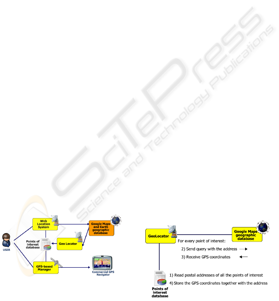
The system is made up of three main modules, as
it can be seen in figure 1, and receives the postal
address of all organization’s centres as input. This
information is specified in a MS WORD document
that is read as an XML file. The first module obtains
the GPS coordinates of the centres using the postal
address read from the document.
Figure 1: Logic representation of the system.
The second one uses these GPS coordinates to
generate several maps with all the points in real
time, allowing the interaction between the user and
the points. One of these maps is shown on Google
Maps including all the points of interest of the
organization. Google Maps is a web-based
geographic information system property of Google.
The system also shows a textual description about
every point on Google Maps. The other kind of
maps generated by this module is shown on Google
Earth (Jones, 2006). This application is similar to
Google Maps, but it is not web-based. It offers the
advantage of provide multimedia content in every
point of interest (Jones, 2007).
The third module is a web service that puts
available all the information of the centres for
different GPS navigators in a web site. Thanks to
this system, customers will have available more than
9 ways to visualize the geographic information of
their organization, one web-based (Google Maps),
another one based on the Google Earth system, and
seven more views for commercial GPS navigators,
as it will be described in the following points.
3.1 Getting GPS Coordinates
One of the most important aspects inside this
development is how to translate postal address into
GPS coordinates. (Diggelen, 2002) The reason is
because it is necessary to know them to allocate
every point in its location.
In order to achieve this translation, a database
with the correspondences between addresses and
GPS coordinates is needed. The solution was to use
a Google service that offers information about places
on a map, allowing interacting with it. This service,
called Google Maps, has an API available to find
information of places through a web service.
In figure 2 this translation process can be seen
graphically. First of all, the ‘Geolocator’ module
read all the addresses from a database. Then it sends
a request of information to the Google Maps API,
specifying the output desired, in this case the GPS
coordinates.
Figure 2: Getting GPS coordinates through the address
using Google Maps database.
WEBIST 2008 - International Conference on Web Information Systems and Technologies
268
The result of this request is an XML document
with all the information related to this address, such
as state, country, postal code, etc. In this case the
only information needed is the X, Y and Z GPS
coordinates. Once all the coordinates of the points of
interest have been obtained they are stored again in a
database.
All this information will be used by other
modules to generate the different views.
3.2 Creating a Web Mapping System
on the Fly
In recent years there has been an explosion of
mapping applications on the web such as Google
Maps, and Live Maps (Teranishi, 2006). These
websites give the public access to huge amounts of
geographic data with an emphasis on aerial
photography (Eick, 2007).
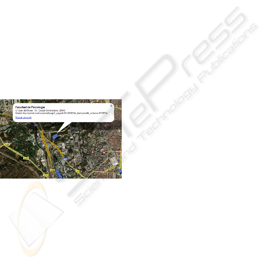
The developed system takes advantage of these
applications, mapping own content into them. As it
can be appreciated in figure 3, it is possible to add
information of every point, such as phone contact,
address, web site, etc.
Figure 3: Mapping content into a Geographic Information
System.
In addition, the system allows looking for any
kind of services near the point of interest. For
example, it is possible to find hotels near a point,
getting a full description of them. Other interesting
searches could be restaurants, rent-a-car companies,
pharmacies, etc. In addition, thanks to this tool, it is
easy to create optimum itineraries from one centre to
another.
The mapping of the website with content of our
organization is carried out using the Google Maps
API. According to it an XML document with all the
information related to the points of interest must be
created and integrated into the Google Maps
website.
This XML document is made up of several
‘Placemark’ tags. Every one of these tags contains
other tags with the information of one point of
interest, including the name, a description, and the
exact GPS coordinates.
When the customer asks for information the
system takes the information of the points of interest
from the database, and generates the XML document
in real time, mapping it into a Google Maps map.
3.3 Mapping Information on Google
Earth
The system also enables a more advanced
visualization mode using Google Earth, that
includes all the functionalities that the Google Maps
representation offers but with less limitations.
In the same way the XML document is created
for Google Maps, another one is created in real-time
for Google Earth. Here it is possible to include not
only textual information of the points of interest, but
also images, audio, videos and even include the
content of other web sites. It opens the door to a
wide range of applications, specially related to
tourist information. For example, it could be
possible to provide multimedia information about
every monument of a city.
3.4 Generating Geographic
Information for Commercial GPS
Navigators
Finally, the last visualization modes are for
commercial GPS navigators. The system generates
geographic information documents for 7 different
kinds of GPS navigators. These documents can be
downloaded from the UNED website through the
Internet connection of the mobile device. Depending
on the kind of navigators the user will choose one
document or another.
Once the mobile device has downloaded the
suitable document, the customer only has to activate
the new points of interest inside his navigator.
This service helps the user to find the best way to
go to any point of the organization using his own
GPS navigator. Thanks to it, the user will have all
the points available inside the navigator.
In addition, many GPS navigators offer the
possibility of finding other services near a point. For
example restaurants, parking, pharmacies, etc.
In figure 4 the files of two different GPS
navigators are shown, Garmin and Navman, they
have totally different contents and structures.
FINDING THE WAY: SERVICES FOR A MULTI-VIEW AND MULTI-PLATFORM GEOGRAPHIC INFORMATION
SYSTEM
269
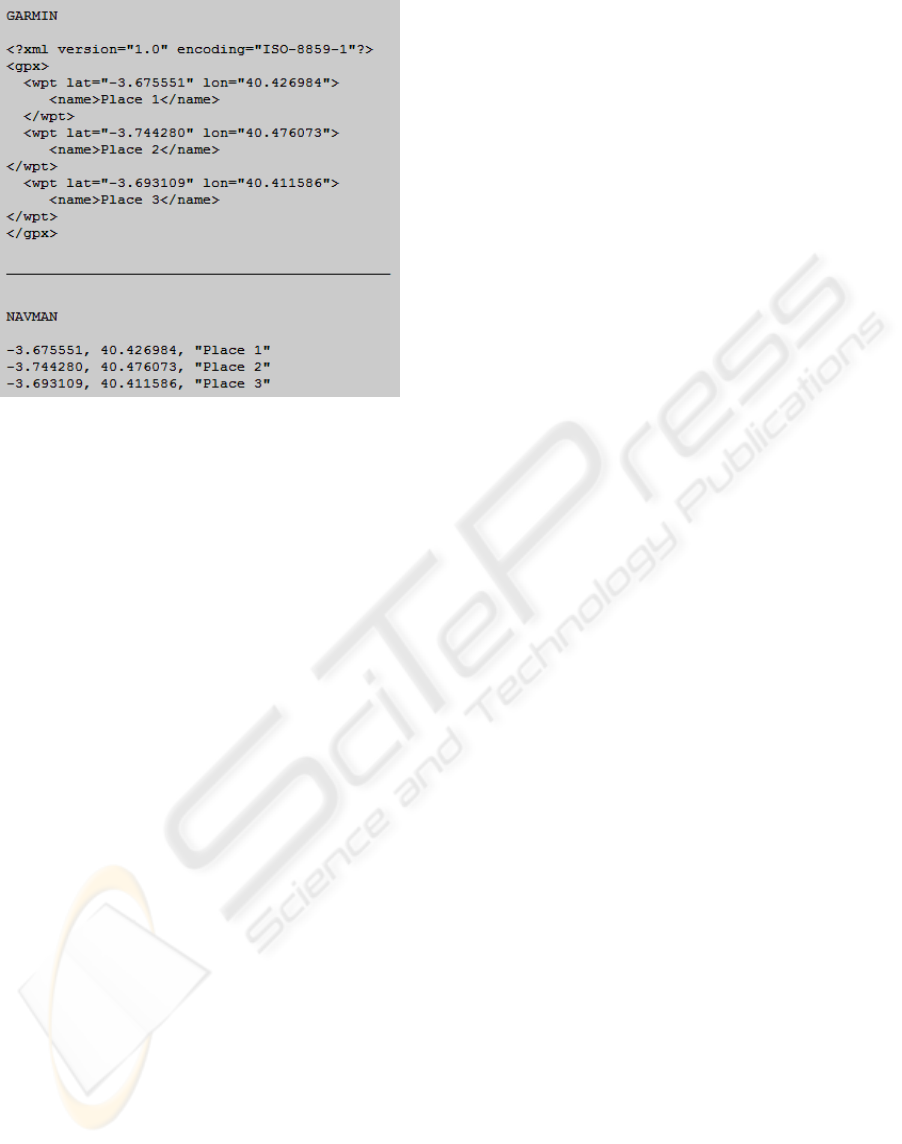
Figure 4: Points of interest files for two different GPS
navigators: Garmin and Navman.
The first one, Garmin, is an XML document
describing every point of interest with the tags:
latitude, longitude and name. In the second case, the
chosen navigator is Navman. It uses a comma-based
schema. In first place appears the latitude, in second
place the longitude and finally the name of the point
of interest. Following these structures is possible to
generate a document with the information of every
point of interest of the organization in real-time.
4 CONCLUSIONS
This paper describes the geographic information
services that are appearing to improve the mobility
not only in the university environment but also
inside any business with mobility needs.
The described system offers different ways of
using the geographic information of an organization.
It uses different programs: web, PC-based, and
different GPS navigators. This is the real added
value of the system, the possibility of generating
different views of the same information from a text
document.
The aim of this development is to offer updated
geographic information in real-time, with
independence of the platform or the device used by
the user. Mobility can not depend on the device, the
operative system or the size of the screen.
This system helps users to find the best way to
go wherever they want to go, using whatever devices
they want to use anytime.
ACKNOWLEDGEMENTS
The authors would like to acknowledge the Spanish
Science and Education Ministry and the Spanish
National Plan I+D+I 2004-2007 the support for this
paper as the project TSI2005-08225-C07-03
"MOSAICLearning: Mobile and electronic learning,
of open code, based on standards, secure, contextual,
personalized and collaborative".
REFERENCES
S. Martín, M. Castro et al, 2006. Ubiquitous and biometric
applications on distance education. An alternative to
the traditional examination. I International Conference
on Ubiquitous Computing: Applications, Technology
and Social Issues, pp. 39-42.
C. Boonthuma, I.B. Levinstein et al, 2007. Mobile
computing: Opportunities for optimization research,
Computer Communications, Volume 30, Issue 4, 26
February 2007, Pages 670-684.
Castro, M., Gil, R., Martin, S. Et al, 2006. New Project on
Secure Education Services for On-Line Learning. 9th
International Conference on Engineering Education.
F. Diggelen 2002, Indoor GPS Ttheory & implementation.
IEEE Position, Location & Navigation Symposium.
D. Saha and A. Mukherjee, 2003. Pervasive Computing: A
Paradigm for the 21st Century, Computer, IEEE
Computer Society, Volume 36, Issue 3, May 2003, pp.
25-31.
W. Jones, 2006. Microsoft and Google vie for virtual
world domination. Spectrum IEEE. Volume 43, Issue
7, July 2006 Page(s):16 – 18
M. Jones, 2007. Google's Geospatial Organizing Principle.
Computer Graphics and Applications, IEEE. Volume
27, Issue 4, July-Aug. 2007 Page(s):8 - 13
Teranishi, Y. et al, 2006. MapWiki: a ubiquitous
collaboration environment on shared maps.
Applications and the Internet Workshops, 2006.
Eick, S., 2007. GeoBoost: An AJAX Web 2.0
Collaborative Geospatial Visualization Framework.
Aerospace Conference, 2007 IEEE. 3-10 March 2007
Page(s): 1 – 10.
WEBIST 2008 - International Conference on Web Information Systems and Technologies
270
