
NEW GENERATION 3D WEB-BASED
GEOGRAPHICAL INFORMATION SYSTEMS
The Importance of Integrated Infrastructures for Territory Management
Giuseppe Conti and Raffaele De Amicis
Graphitech, Via Alla Cascata 56/C, Trento, Italy
Keywords: 3D Geobrowser, web services, training, SDI – Spatial Data Infrastructure, INSPIRE (INfrastructure for
SPatial InfoRmation in Europe).
Abstract: This paper highlights the importance of developing new tools capable of providing interactive web-based
access to cross-border geographical data. This new generation of tools could be essential to improve the
management of the territory and its infrastructures as well as to support training of operators responsible for
crisis management at large scale. The paper illustrates the benefit of integrating the potential of 3D
computer graphics with integrated web-service based geographical infrastructures. The paper discusses how
recent technical developments, together with the definition of an international legal framework, is paving
the way for such a new generation of management and training tools.
1 INTRODUCTION
In recent days web-based geographical information
system are undergoing a profound evolution. This is
characterised by a radical shift from traditional
monolithic systems, composed by think clients
accessing centralised geo-databases, to more
distributed architectures based on web-services,
providing integrated and interoperable access to
geographical data and service.
This major evolution is being sustained by the
emerging EU legislation in the domain of public
access and use of geographical data. Most notably
the INSPIRE directive (INfrastructure for SPatial
InfoRmation in Europe) represent a turning point as
it will oblige all EU countries to converge towards a
European interoperable infrastructures of
geographical web services.
Concurrently the availability of 3D Geobrowsers,
usually considered as the natural evolution of Web-
based Geographical Information Systems (GIS), is
enjoying an increasing success due to the popularity
of applications such as Google Earth or Microsoft
Virtual Earth. The potential of these application
should be extended from its present state to planning
and management use based on the access of
interoperable geographical data and service which is
being made available.
This unique circumstance is paving the way to a
new generation of applications, capable to benefit
from interactive 3D-based access to distributed
cross-border geographical data and services.
These applications could be used for a wide
range of territory management activities but most
importantly for training of administrators and
operators who are responsible for managing acute
crisis. In fact the use of 3D visualisation
technologies and GIS can be combined with
simulation tools to provide training application
capable to improve the decision support during relief
operation following security large scale incidents.
2 THE ROLE OF SPATIAL DATA
INFRASTRUCTURES
Widespread diffusion of web-based geographical
information systems is having a profound effect on
the process of management of a territory as it is
yielding to the creation of integrated systems of
geographical services to be used by politicians,
administrators, technicians and citizens.
This scenario is providing the condition for the
widespread diffusion of the so-called Spatial Data
Infrastructures (SDIs), whose concept goes far
beyond the concept of centralised web-centred geo-
347
Conti G. and De Amicis R. (2008).
NEW GENERATION 3D WEB-BASED GEOGRAPHICAL INFORMATION SYSTEMS - The Importance of Integrated Infrastructures for Territory
Management.
In Proceedings of the Fourth International Conference on Web Information Systems and Technologies, pages 347-350
DOI: 10.5220/0001531903470350
Copyright
c
SciTePress

database as it yields to integrated frameworks
capable to provide access to a large number of
geographical web services. These in turn can be built
on top of a wide range of geographical data owned
by private companies as well as by public
administrations.
However it would not be appropriate to consider
SDIs as just a mere set of interoperable technologies
communicating through some well know protocol.
Rather a more general perspective should be taken,
in order to consider them as an entangled set of
politics, institutional frameworks, technologies, data
and people that can make the sharing of
geographical information more efficient and
accurate.
SDIs in fact represent a tool of fundamental
importance for the governance of a territory as they
deployment allows more precise analysis, more
efficient control and a more attentive planning,
effectively responding to the real needs of a
territory. The deployment of an SDIs can represent
the basis for the creation of a wide range of web-
based services capable to provide integrated
management of regions. At the same time they can
provide citizens with access to data repositories of
public interest containing spatial as well as statistical
information relative to the territory.
From a mere technological perspective an SDI
can then be considered as a complex system of
hardware and software components geographically
distributed yet interconnected in a Service Oriented
Architecture (SOA). They can deploy web services
which can be used to provide specific functionalities
to clients, to access data repository as well as to
transform data within a fully interoperable
environment.
Such an interlinked approach allows the
definition of cross dependencies and competency
regions within and among different SDIs. In fact as
each operator becomes responsible for the
management and publication of its own data and
services while it can seamlessly benefit from having
interoperable access to data and services managed
by other operator.
It is acknowledged that SDIs will play a
fundamental role in the governance of a territory as
they can provide different institutional actors such as
politicians, administrators, technicians, decision
makers, with the proper tools for a complete
planning activity and integrated management of the
territory. A further advantage is that SDIs can
provide access to certified spatial data both to the
professionals and to the citizens according to a
paradigm that promotes e-democracy.
The interest being raised by SDIs at the global
level is testified by the significant economical
resources allocated in the last few years to their
deployment. According to a recent study
(Crompvoets, 2006) from the University of
Wageningen in The Netherlands, the absolute
majority of countries in the world already has or it is
in the process of deploying a National SDI or, as
often referred to, a NSDI.
These initiative at regional or national level are
accompanied by similar relevant initiatives at the
international stage both within and outside the EU,
all aiming at the integration of geographical services
beyond the national borders.
Web-based data and service interoperability at
the international level in fact is essential to
guarantee immediate response in case of large scale
crisis. Having fast access to geographical data from
other countries in fact can be essential to coordinate
international cooperation activities in case of large
natural or manmade large scale disaster such as
widespread floods, major earthquakes or terrorist
attacks.
Cross-border interoperable access to
geographical data is particularly important to
manage data on large scale pan-European critical
infrastructures such as the so-called Trans-European
Transport Network TEN-T (European Commission
2007a). TEN-T, as well as other EU-wide key
strategic assets, are highly complex cross-border
interconnected networks and they are naturally very
vulnerable to natural or man-made disaster events.
Several recent major accidents such as those at the
Gotthard and Tauern tunnels, with complete closures
of weeks and sometimes months, have highlighted
such problems (El-Araby, 2002). The social and
economical costs for the consequent disruption are
enormous as closing down a motorway such as the
A9 in France, can cost up to 300,000 Euros/day only
in terms of revenues lost (ASECAP, 2006).
The deployment of web-based systems based on
systems of SDIs plays a strategic role as it can
provide coordination of information in case of
exceptional events or crisis, when being able to
access geographical data in a transparent yet
interoperable manner becomes essential for the
public safety.
WEBIST 2008 - International Conference on Web Information Systems and Technologies
348

3 THE INTERNATIONAL
OUTLOOK
The deployment of SDIs at the EU level has been
subject of the forthcoming European legislation and
specifically of the INSPIRE directive which will
enforce the creation of the ESDI – European Spatial
Data Infrastructure. This is emerging as the result of
a significant effort at the European level and it is
bringing to a network of interoperable SDIs of
national as well as regional level.
The INSPIRE directive (INfrastructure for
SPatial InfoRmation in Europe), in force since 15-
05-2007, is in fact promoting the development of the
ESDI, the European network of Spatial Data
Infrastructures based on the definition of specific
rules for interoperable data and web services. Today
a vast technological as well as political effort is
being spent to produce the implementing rules which
will define the specification of processes, data and
services that each country will have to deploy.
Other significant EU initiatives include GMES
(Global Monitoring for Environment and Security),
the proposal for a EU Directive on “the
Identification and Designation of European Critical
Infrastructure and the Assessment of the Need to
Improve their Protection” (European Commission,
2006a) as well as the “European Programme for
Critical Infrastructure Protection (EPCIP)”
(European Commission, 2006b).
All these initiatives clearly show how the control
of the territory and its security has very high priority
in the EU agenda.
4 THE NEED FOR ADVANCED
3D SERVICES
Within such a scenario the evolution of web services
capable to provide interactive access to 3D
geographical data can play a decisive role.
Interactive web-based systems such as 3D
geobrowsers in fact can be used as front end to
access data and services made available by SDIs.
Furthermore these can represent the basis to build
effective training systems for managing the territory,
to plan its activities as well as to train
administrators, decision makers and crisis managers.
This is of utmost importance to provide the most
adequate decision support during relief operation
following security incidents.
For this reason it is essential to foster the
development of collaborative real-time simulation
systems capable to access data from SDIs and to
support coordination during crisis management.
Specifically developed 3D interactive geo-
referenced simulation environments need to be
developed to support training of cross-boundary
emergency teams. The use of technologies such as
virtual and augmented reality technologies, on top of
standard web-based services, may ensure high level
of immersiveness and realism. The ability of
interacting in real time with the 3D environment
becomes extremely important. This requires real-
time visualisation of 3D representation of data
patterns coming from sensors, 3D representation of
features present in a database, interactive creation
and modification of existing geometries representing
specific data sets, the possibility to introduce objects
retrieved from existing libraries.
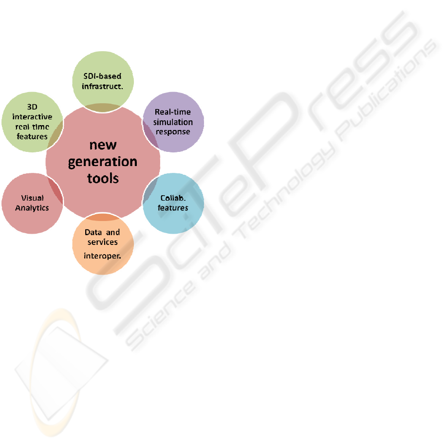
As illustrated in Figure 1 new generation systems
will further need to be supported by the use of novel
forms of Visual Analytics, essential for fast filtering
of complex information and for the identification of
key data patterns emerging from the simulated crisis
scenario.
This position is shared by several institutions
such as AISCAT (AISCAT, 2006), the association
that groups all motorway and tunnel concessionaire
companies operating in Italy, EU’s first top priority
actions should be to provide adequate support for
crisis and management of major events. These must
not be limited to terrorist attacks but they have to
provide support to major accidents as well as major
weather-related events which can affect all major
infrastructures. This position is also in line with
European Programme for Critical Infrastructure
Protection (European Commission 2007b) which
fosters the development of simulation and training
tools to anticipate proper countermeasures, to help
assess the level of defence and improve security
flaws.
Recent geo-political developments, generated by
the enlargement of the EU countries to new nations,
further amplifies the scope of this issue and it poses
new challenges in terms of cross-border scenarios,
where having access to harmonized and
interoperable data is essential importance.
New generation of web-based services, based on
access of geographical data made available by SDIs,
could provide an adequate response to this issue.
Planning on how to handle acute crises is of
prime importance for adequate response. The impact
of proper modelling and simulation tools is very
high both in social and economical terms as proper
NEW GENERATION 3D WEB-BASED GEOGRAPHICAL INFORMATION SYSTEMS - The Importance of Integrated
Infrastructures for Territory Management
349
cross border crisis management can potentially save
lives and bring to huge costs saving.
The ability to react to critical events during a
crisis is therefore a crucial skill for crisis managers
which can only be developed through
comprehensive training. This needs to be capable of
accessing, distributing and processing a wide range
of Geographic Information (GI), such as sensor data,
to support strategic large-scale decision-making
process. To be able to provide full immersiveness
and realism crisis manager need to be supported by
simulation systems capable to create cross border 3D
virtual environments capable to respond
interactively to the managers' actions.
Figure 1: features required by next generation
management and training infrastructures.
5 CONCLUSIONS
The emerging need for new tools capable of
providing adequate control over the territory is
driving a number of international initiatives with the
aim of deploying harmonised international network
of geographical web services. The concurrent
technical development has brought to the
development of 3D real-time applications capable to
deal with very large geographical dataset.
This convergence is setting the base for a new
technological and methodological shift, by providing
the basis for the arrival of a new generation of
management and training systems for large scale
scenarios.
Their development, grounded upon the deployment
of EU wide Spatial Data Infrastructures, will
represent a major achievement as it will allow
interactive interoperable access to pan European
geographical data. This will be essential to the
development of new management and training
systems for politicians, administrator, decision
makers and crisis managers.
REFERENCES
Crompvoets, J., 2006. World Status of National Spatial
Data Clearinghouses. Worldwide Development and
Impact, Viewed on 05 December 2007,
<http://library.wur.nl/wda/dissertations/dis3894.pdf>
European Commission, 2007a. Trans-European Transport
Networks, Viewed on 05 December 2007,
<http://ec.europa.eu/ten/transport/index_en.htm>
European Commission, 2007b. EPCIP – European
Programme for Critical Infrastructure Protection,
Viewed on 05 December 2007, <
http://ec.europa.eu/justice_home/funding/2004_2007/e
pcip/funding_epcip_en.htm#>
European Commission, 2006a. Proposal for a Directive of
the Council on the identification and designation of
European Critical Infrastructure and the assessment
of the need to improve their protection.
European Commission, 2006b. Communication from the
Commission on a European Programme for Critical
Infrastructure Protection..
AISCAT, 2006. Position paper on European
Commission’s Green Paper on a European
Programme for Critical Infrastructure Protection.
El-Araby, K. (2002). Cross-Broder Traffic Management
for Non-Recurrent Events in the Central European
Alpine Region, Transportation Planning and
Technology, Vol. 25, pp. 289-310.
ASECAP, 2006. An ASECAP Reflection on the High
Level Group Report on the Extension of the Major
Trans-European Axes to the Neighbouring Countries
and Regions. .
WEBIST 2008 - International Conference on Web Information Systems and Technologies
350
