
A STUDY OF THE SPATIAL REPRESENTATION IN
MULTIDIMENSIONAL MODELS
Concepción M. Gascueña
Department of Computing, Carlos III de Madrid University, Avd. University 30, 28911 Leganés, Spain
Rafael Guadalupe
Department of Topographic, Politécnica de Madrid University, Carretera de Valencia Km7, 28031 Madrid, Spain
Keywords: Data Structures, Databases, Database Theory, Multidimensional Databases, Spatial Granularity Semantics,
Spatio-Temporal Multigranularity Semantics, Databases and Information Systems Integration.
Abstract: In this work, we do an analysis on the different models proposed to model Multidimensional Databases
MDB, and Spatial Databases SD. We analyze the basic and advanced rules that the conceptual
multidimensional models should to support, according sort criterion exposed for some authors. As result of
this study, we propose to add new rules to gather the spatial and temporal semantics. Are analyzed some of
models more relevant, and a comparative table is presented, where the advantages of the model called
FactEntity FE, with respect to the other examined modes, to collect multidimensional and spatial semantics,
is obvious. We emphasizing on the novel contributions of FE model and shortcomings of the rest of seen
models. We besides show a formalization of the FE model with a metamodel made up with the extended ER
model, where the semantics of FE model is representing. Finally, an example of application clarifies our
exposure.
1 INTRODUCTION
The Decision Support Systems and the Geographic
Information Systems GIS, use the Data Warehouses
or Multidimensional Databases MDB. The GIS
locates spatial data on the Earth’s surface and
studies its evolution through time. The
Multidimensional databases MDB, allow the storing
of data in a special way to study these from different
perspectives or dimensions and with different detail
levels or granularities. The most proposals to model
MDB reuse the models of operational databases DB,
as the Entity Relation ER, or the Unified Modelling
Language UML, although they are not appropriating
to model these databases, since, they were conceived
for other purposes. We believe as the authors in
(Golfarelli, 1998), (Torlone, 2003), (Kimball, 1996)
, that traditional conceptual models are not able to
express all the semantics of the MDB, and we too
are in agreement with (Piattini, 2006), which speak
on the immaturity of multidimensional technologies.
In addition, the GIS, require models that support
the process of reasoning about space, and that allow
us to gather spatial data in different scales
connected, as is commented in (William, 2006). For
all above, we believe that specific models, that can
to collect the multidimensional semantics and spatial
semantics, are needs.
In this work, we are going to study on the one
hand, the proposals that are to model MDB; and on
the other hand, the proposals that are to include the
space in the DB in general. In addition, we do a
comparative study on several of more relevant
models, to analyze how they to deal the spatio-
temporal multigranularities. We stress the proposal
in (Gascueña, 08), where the model called
FactEntity FE, is presented, which permit us to
collect multidimensional and spatial semantics. The
FE model allows treating the different types of
spatial granularity, Semantic and Geometric, which
in the study of (Gascueña, 08), are distinguished.
This model supports related spatial, temporal and
thematic granularities interacting between them.
None of the models studied collect previous
characteristics.
339
M. Gascueña C. and Guadalupe R. (2008).
A STUDY OF THE SPATIAL REPRESENTATION IN MULTIDIMENSIONAL MODELS.
In Proceedings of the Tenth International Conference on Enterprise Information Systems - DISI, pages 339-348
DOI: 10.5220/0001715503390348
Copyright
c
SciTePress

This paper is structuring, as follows: Section 2
includes a extend study on related works in
multidimensional and spatial semantics and in
addition, the rules provided by some authors, as
necessary to the conceptual multidimensional MD,
models, along other new rules, are exposed. Besides,
a comparative table, between some more relevant
model and the FE model, is showing. In Section 3,
we present briefly the FE model, which include
graphical representation and a Metamodel. The
Section 4 includes an illustrative example. In section
5, some conclusions and future work are given.
2 RELATED WORK
Most of the models proposed to design MDB from a
conceptual approach, are basing on concepts
modelled from traditional DB and present extensions
to the ER model such as in (Sapia, 1999). Other
models, (Malinowski, 2004a) and (Golfarelli, 1998),
adopt the starting point of an ER model providing
guidelines for its transformation into a
multidimensional MD model. In the StarER model
(Tryfona, 1999) , there is a proposal to use the Star
multidimensional model together with an extension
of the ER model. Other authors such as (Lujan-
Mora, 2006) and (Abello, 2006) present extensions
to the UML model. Although researchers such as
(Torlone, 2003) and (Kimball, 1996) consider, as we
do, that the traditional data models are not adapted
to represent the special semantics of MDB. Some
classifications of the most important characteristics
that must be gathered in a conceptual MD model, are
shown in (Torlone, 2003), (Abello, 2000),
(Malinowski, 2004a), and (Lujan-Mora, 2006). The
authors in (Abello, 2000), propose to design the
conceptual phase in three levels of detail increasing
in complexity; with this design approach, a model
called YAM2 presenting in (Abello, 2002), and
(Abello, 2006), which uses an extension of UML
model. The model in (Torlone, 2003) is presenting
from a conceptual point of view and it specifies the
basic and advanced characteristics that an ideal
conceptual MD model would have. In (Lujan-Mora,
2006) the cardinalities in the hierarchies are
considering and classified with concepts such as
strictness and completeness; in addition, the additive
of measures and the representation of some
aggregation operators are exposed; they use the
language Object Constraint Language (OCL) to
specify constraints. A classification of the different
hierarchies (with regard to the cardinality between
the different hierarchical levels) that must support a
model is presenting in (Malinowski, 2004a). This
work is completing in (Malinowski, 2005), where it
is defining as transforming these hierarchies into the
logical model under the relational paradigm.
2.1 Space and Time in MDMs
Three types of space dimensions (depending on
whether the space elements are included in all, some
or none of the levels of the dimensional hierarchies)
and two types of measures (space or numerical
measures) are distinguishing in (Stefanovic, 2000).
In (Malinowski, 2004a) the inclusion of the spatial
data at a level of a hierarchy or as measures is
proposing, though they do not include the spatial
granularity. In (Malinowski, 2005), the same authors
present a classification of the space hierarchies
following the criteria set in (Malinowski, 2004a),
(with regard to the cardinality). A study is presenting
on the temporality of the data at column and row
level in (Malinowski, 2006). None of the previous
works contemplates spatio-temporal
multigranularity. In (Gascueña, 2006) is studied the
multigranularity of the spatial data from a logical
approach. In (Gascueña, 2005) is detailed a
comparative view of how to deal the spatio-temporal
multigranularity with two different logical models:
Object Oriented (OO) and Multidimensional. In
(Gascueña, 2008) is presented the specific
FactEntity multidimensional model, from a
conceptual approach, which gather the spatio-
temporal multigranularities. In addition, these
authors make up a study on how to represent the
spatial granularity in a MDB, and distinguish
between Semantic and Geometric granularities.
2.2 Space and Time in OO Models
The treatment of the multigranularity in OO models
exists, as in the work of (Camossi, 2003) that
extends Object Data Management Group (ODMG),
for the inclusion of this concept in its model called
Spatio Temporal ODMG (T_ODMG). The
ST_ODMG model supports the handling of entities
with a spatial extension that changes their position
on temporary maps. It provides a frame for mapping
the movement of a moving spatial entity through a
geographic area, where the spatial objects can be
expressing at different levels of detail.
In (Khatri,
2006) a study on the spatio-temporal granularities by
means of ontology is carrying out. They propose to
model it in two phases: first, by using a conventional
conceptual ER model, without considering spatial or
temporal aspects, it would model “what”. In the
ICEIS 2008 - International Conference on Enterprise Information Systems
340

second phase, it completes with notations or labels
that gather the associated semantics of time and
space, “when and where”, as well as the movement
of the spatial objects, although they only handle one
granularity for each spatial data. In (Parent, 1999) it
shows the MADS model as an extension of the ER
model, although it uses elements OO and some
authors present it as a hybrid between OO and ER. It
uses complex structures and abstract types of data to
support the definition of domains associated with
space and time over object and relations. But none
of the proposed models above distinguish, between
Semantic and Geometric spatial granularities, as we
do.
2.3 Multi-representation
In reference (Parent, 2006) an extension to the MAD
model is added to handle multiple resolutions in the
geographic databases. It presents four orthogonal
dimensions in order to model: data structures, space,
time and representation. It distinguishes two
approaches to support multiple spatial resolutions.
The multi-resolution approach only stores the data of
the upper level of resolution, delegating the
simplification and space generalization to the
databases system. The multi-representational
approach stores the data at different levels of
resolution and allows the objects to have multiple
geometries. In (Bedard, 1999) and (Borges, 2001)
objects with different interpretations and scales are
defined. In (Timpf, 1999) series of maps, are used
and handle with hierarchies. In (Jones, 1996) objects
with different representations (multi-scale) are
associated. In (Sell, 1998) the objects at different
levels of detail are organized, such as stratified
maps. In (Bedard, 2002) the concept of “VUEL”
(View Element) and new definitions of multi-
representation are introduced with four dimensions:
semantics, graphic, geometry and associated scale. It
proposes to model the space using the expressivity
of the MD models, where the spatial data is dealt
with in the table of facts and the dimensions are
marking the different semantics of multi-
representation, although it is not a MD
multidimensional. The Geo_Frame-T model
(Vargas, 2001) uses the OO paradigm and an
extension of UML model, and introduces a set of
temporal and space stereotypes to describe the
elements and the class diagram. The Temporal
Spatial ER STER, model is presented in (Tryfona,
2003) as an extension of the ER model maintaining
the concepts used in ER and including sets of spatial
entities. In (Le, 2005) space and temporal data
models for Temporal GIS is proposed. The
integration of multiple representations is basing on
common spatial and temporal reference systems. It
uses layers to keep the spatial data, one layer for
each space representation in a determined time. For
the evolution through time, it uses a layer for each
spatial element and every moment of time. It
distinguishes between temporal representations
based on characteristics and data models based on
layers. It uses the map itself with different thematic
data in the time interval itself.
None of these models support multidimensional
concepts, for this reason they are not adapted to
model the multidimensional semantic; in addition
neither do they distinguish between Semantic and
Geometric spatial granularities. The study done in
(Gascueña, 2008) separate the way of divide a space
of interest for semantic qualities; and the way to
store this space by geometries in a DB; and in
addition, the way of represent this space in a
computer, when it is recovered from a DB.
This section has carried out the study of data
models from the focus of MDB and from the focus
of DB in general. It has verified that a great effort
have been made, to gather the space and temporal
characteristics of the data in traditional models. But,
there are not specific approaches for the MD models
that gather the spatio-temporal multigranularities
considered in (Gascueña, 2008), only the FE model
define their own constructors to gather the specific
multidimensional and spatio-temporal semantics,
which justifies our proposal to use the FE model.
2.4 Rules to the MD models
The authors in (Blaschaka, 98), (Pedersen, 00),
(Torlone, 01), (Abello, 00), (Abello, 02),
(Malinowski, 04a), propose the basic and advanced
rules that the conceptual MD models must comply.
We look these in Tables 1, 2, 3 and 4.
Table 1: Basic rules according to (Pedersen, 2000),
(Blaschaka, 1998), (Torlone, 2001).
Explicit separation of structure and content
Explicit notions of dimension and data cube
Explicit hierarchies in dimensions
Multiple hierarchies in each dimension
Level attributes
Measures sets
Symmetric treatment of dimensions and measures
Explicit separation of structure and content
Explicit notions of dimension and data cube
Explicit hierarchies in dimensions
Multiple hierarchies in each dimension
Level attributes
Measures sets
Symmetric treatment of dimensions and measures
A STUDY OF THE SPATIAL REPRESENTATION IN MULTIDIMENSIONAL MODELS
341
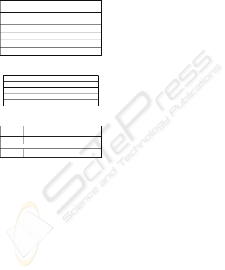
Table 2: Advanced characteristics proposal for (Torlone,
2001).
Support for semantic
aggregations
The FE model include explicit specification over as to make up
the aggregation
Support for non standard aggregations of facts
Non-strict hierarchies Relationship (N:M) between parent/child levels of dimensions
Non-onto hierarchies
Parent level without representation in child level. We control this
whit the cardinalities (1,1)Æ (0,n)
Non covering hierarchies
Child level without representation in inmediate superior parent
level. We control this whit the cardinalities (0,1)Æ (1,n)
Many relationships between
facts and dimensions
We think that it is not semantically correct, though our model
allows its representation
Handling change and time
The FE model incorporates: Temporal factEntity, Temporal level
and Temporal attribute
Handling vagueness
The FE model allow us to include all the semantic necessary for
what this problem to be known and controlled.
Table 3: Characteristics proposed for (Abello, 2000),
(Abello, 2002).
It allows us to see several fact in a scheme
Identification of facts
Mathematical constructs used for operations
Elements over which operations are defined
User defined aggregation functions
It allows us to see several fact in a scheme
Identification of facts
Mathematical constructs used for operations
Elements over which operations are defined
User defined aggregation functions
Table 4: Characteristics proposed for (Malinowski,
2004b).
Symmetrical
hierarchy
For each member m of a level there at least a member m’ of the inferior
level and for each member m’ of a level there only a member m of the
superior level. Cardinality (1,1) Æ (1,n) parent/child
Multiple alternative
hierarchies
Several non-exclusive simple hierarchies sharing some levels but with the
same analysis criterion.
Parallel hierarchies: A dimension has several hierarchies but with different analysis criterion
Dependent Different hierarchies sharing some levels
Independent Different hierarchies do not sharing levels.
We also added the following rules, to gather the
spatial component:
Spatial Multigranularity (it is support for the
multi-representation): Semantic and Geometric
granularities.
Temporal Multigranularity into different
structures: factEntity, hierarchical level, attribute.
Spatio-Temporal Multigranularity is the
possibility to represent on the scheme different
granularities related and interacting. The FE model
in (Gascuenña, 2008) supports all the previous
characteristic.
2.5 A View Comparative between some
Models
Table 5 shows a comparison between some of the
most outstanding models. We observe that in
(Trifona, 2003), (Golfarelli, 1998), (Sapia, 1999),
(Abello, 2006), and (Torlone, 2001), they do not
support all the multidimensional hierarchies
proposed in for (Ma&Zi, 2004b), this work does the
classification of hierarchies with regard to the
cardinalities. Only the FE model in (Gascueña,
2008) supports the temporal multigranularities in all
the structures as factEntity, hierarchical level, and
attribute.
The Semantic and Geometric spatial granularities are
not defined and therefore do not supports, for any
models excepting the FE model, although some
authors as (Parent, 2005), (Khatri, 2006), (Trifona,
2003), (Malinowski, 2004a) consider the spatial
granularity of different way as we do. The models
(Trifona, 1999a), (Sapia, 1999a), (Torlone, 2001)
not representing multiple facts in the scheme. The
explicit aggregation of measures, that is, the explicit
representation of the functions that are applied to
each measure fact, when the granularities change, is
partially gathered in (Tryfona, 2003), (Lujan-Mora,
2006), (Golfarelli, 1998), (Sapia, 1999a), (Abello,
2006), and is not gathered in (Torlone, 2001), and
(Malinowski, 2004a), the FE model in (Gascueña,
2008) gathers totally this characteristic. In addition,
any of the models studied, except (Gascueña, 2008),
represent the spatial conversion functions that are to
apply when a spatial element changes to a coarser
granularity. In conclusion, only the FE model
supports completely all the characteristics shown in
Table 5, from a conceptual multidimensional
approach.
3 FACTENTITY MODEL
A multidimensional model allows us to study certain
facts under the perspective of certain dimensions and
with different levels of detail or granularities. We
show briefly The FE model, for more details see
(Gascueña, 2008).
3.1 Spatial Characteristics
We define a Spatial data type as an abstract data
type that contains an identifier, a unit of
measurement within a given reference system, a
geometry of representation associated with this unit,
and a dimension associated with this geometry.
Points associated to kilometers are examples of
geometrics associated to units in a reference system.
See table 6.
ICEIS 2008 - International Conference on Enterprise Information Systems
342
Table 5: Comparing models.
Y = yes NT = no otallly N = no L = logical C = conceptual OO = object oriented R = relational
- = the script means that the model does not contemplate that characteristic
Y = yes NT = no otallly N = no L = logical C = conceptual OO = object oriented R = relational
- = the script means that the model does not contemplate that characteristic
[Parent,05] MADS C E/R&UML OO N - NT NT - - -
[Khatri,06] DISTILL CE/RRN-NTNT---
[Tryfona,03] STER CE/RRN-NTNT---
[Tryfona,99] StarER C E/R R Y NT NT N N NT N
[Luján-Mora,06]
MDLujan-Mora
C UML OO Y Y NT N Y NT N
[Golfarelli,98b] DF C E/R R Y NT NT N Y NT N
[Sapia,99a] M/ER C E/R R Y NT NT N N NT N
[Abelló,06] YAM2 CUMLOOYNTNTNYNTN
[Torlone,01]
MDTorlone
C - RYNTNTNNNN
[Malinowski,04a]
SpatialMultiDiER
C E/R RYYNTNYNN
[Gascueña, 08]
FactEntity
C--R/&
OR
YYYYYYY
Enfoque
Extension
Paradigm
Multidimensional
Hierarchies
(cardinality)
Temporal
Multigranularity
Spatial
Multigranularity:
Geometric/Seman.
Multi Facts
Explicity
Agregation of
Measures
Function to change
the Granularity
[Parent,05] MADS C E/R&UML OO N - NT NT - - -
[Khatri,06] DISTILL CE/RRN-NTNT---
[Tryfona,03] STER CE/RRN-NTNT---
[Tryfona,99] StarER C E/R R Y NT NT N N NT N
[Luján-Mora,06]
MDLujan-Mora
C UML OO Y Y NT N Y NT N
[Golfarelli,98b] DF C E/R R Y NT NT N Y NT N
[Sapia,99a] M/ER C E/R R Y NT NT N N NT N
[Abelló,06] YAM2 CUMLOOYNTNTNYNTN
[Torlone,01]
MDTorlone
C - RYNTNTNNNN
[Malinowski,04a]
SpatialMultiDiER
C E/R RYYNTNYNN
[Gascueña, 08]
FactEntity
C--R/&
OR
YYYYYYY
C E/R&UML OO N - NT NT - - -
[Khatri,06] DISTILL CE/RRN-NTNT---
[Tryfona,03] STER CE/RRN-NTNT---
[Tryfona,99] StarER C E/R R Y NT NT N N NT N
[Luján-Mora,06]
MDLujan-Mora
C UML OO Y Y NT N Y NT N
[Golfarelli,98b] DF C E/R R Y NT NT N Y NT N
[Sapia,99a] M/ER C E/R R Y NT NT N N NT N
[Abelló,06] YAM2 CUMLOOYNTNTNYNTN
[Torlone,01]
MDTorlone
C - RYNTNTNNNN
[Malinowski,04a]
SpatialMultiDiER
C E/R RYYNTNYNN
[Gascueña, 08]
FactEntity
C--R/&
OR
YYYYYYY
Enfoque
Extension
Paradigm
Multidimensional
Hierarchies
(cardinality)
Temporal
Multigranularity
Spatial
Multigranularity:
Geometric/Seman.
Multi Facts
Explicity
Agregation of
Measures
Function to change
the Granularity
Table 6: Spatial data and topological relations.
Cros Point and LinePoint
Cross Line and LineLine
Cross Surface and LineSurface
Topological RelationshipaSapatial Data Type
Cros Point and LinePoint
Cross Line and LineLine
Cross Surface and LineSurface
Topological RelationshipaSapatial Data Type
Spatial granularity is the chosen detail level to
analyse the spatial data. We distinguish two types
Semantic and Geometric granularities. The Semantic
spatial granularity considers space divided by
means of a semantic characteristic; for example
political limits countries, etc. In Table 7, we can see
some spatial functions used when the Semantic
granularity changes. A set of Semantic
granularities enables us to consider the space
divided as bigger or smaller units that are “part-of”
a total, where, each part is considered a unique
spatial element.
Table 7: Spatial functions.
User Defined
Median, most frequent, rank,… Required new calculations using
the data of the leaf level
Holistic
Average, Variance, Standard deviation,… Need an additional
treatment for reusing the values
Algebraic
Sum, Min, Max,… Reuse aggregates of a lower level of a
hierarchy in order to calculate the aggregates for higher level
Distributive
A Geometric spatial granularity is defining as
the unit of measurement, in a space reference
system, associated with geometry of representation.
A set of Geometric spatial granularities allow
representing the same spatial data in different forms
and size in a moment of time. In table 8, we can see
some functions used when the Geometric spatial
granularity changes the other greater one.
Table 8: Spatial conversion functions (Berloto, 1998).
It contracts an open line, endpoints included, to a pointl_contr
It contracts a simple connect region and its boundary to a pointr_contr
Absorption operations ….
Merge, functions …….
It reduces a region and its boundary lines to a liner_thinning
Contract functions
It contracts an open line, endpoints included, to a pointl_contr
It contracts a simple connect region and its boundary to a pointr_contr
Absorption operations ….
Merge, functions …….
It reduces a region and its boundary lines to a liner_thinning
Contract functions
3.2 Temporal Characteristics
The FE model, allows representing temporal
characteristics on different structures as factEntity,
hierarchical level, and attribute; which we called
Temporal FactEntity; Temporal Level and Temporal
Attribute respectively. We consider the temporal
characteristics called: Type of Time, Evolution and
Granularity. The Type of time: (TT) represents the
Transaction Time, (VT) represents the Valid Time
and (TVT) represents the combination of both. The
Evolution considers Specific evolution and
Historical evolution, the former only gathers the
new values, and the moment in which a change has
happened; the latter keeps all the values and
moments in which the changes have happened. A
A STUDY OF THE SPATIAL REPRESENTATION IN MULTIDIMENSIONAL MODELS
343
Granularity is one partition of a time domain chosen
to represent an event, and is the maximum update
frequency of an object or element.
3.3 Multigranularity Characteristics
We define the spatial multi-granularity as a spatial
characteristic that allows us to represent a space of
interest with different Semantic granularities, where
each Semantic granularity can have one or several
Geometric granularities different. The temporal
multi-granularity is a characteristic that allows us to
represent the changes of an element or group in
different temporal granularities. The spatio-temporal
multi-granularity allows us to represent a spatial
data with both: spatial multi-granularity and
temporal multi-granularity.
3.4 Elements
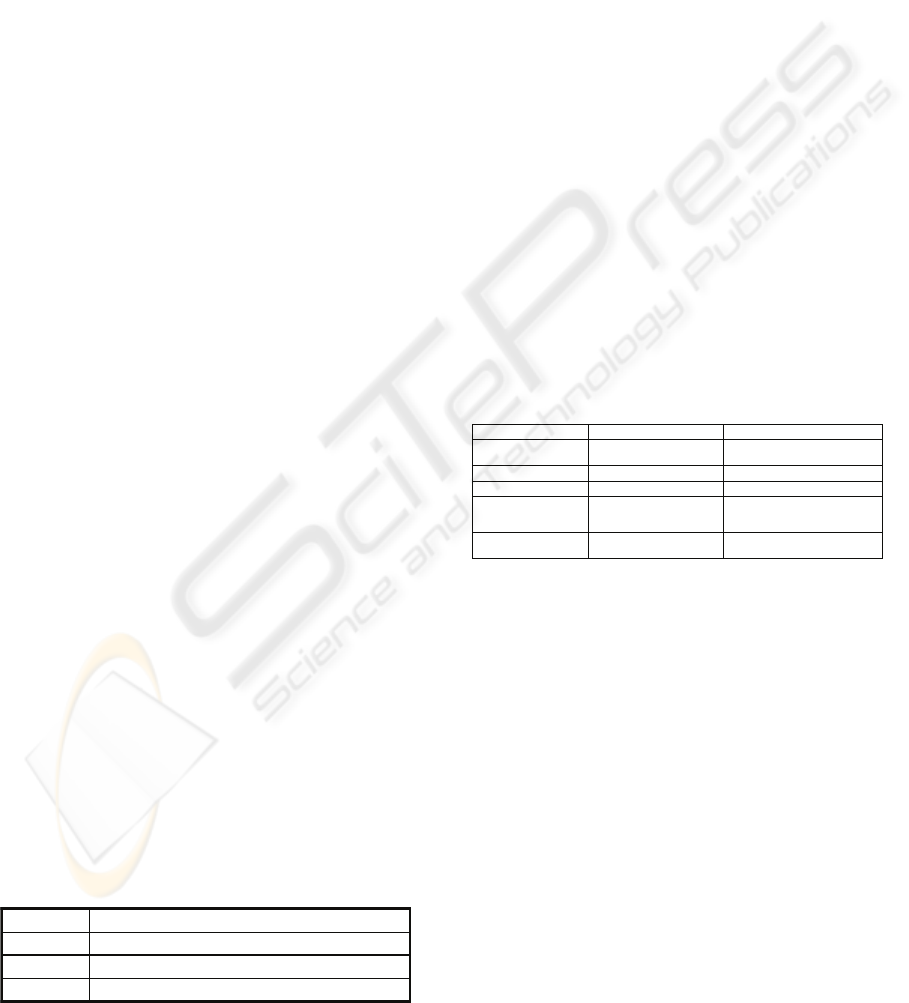
The FE model has two main concepts: dimension
and factEntities.
A factEntity contains only a fact, which is the
object of study and focus of analysis. A fact makes
up one or various measures. The dimensions are the
different perspectives under which we wish to
observe this fact. The FE model, allows an explicit
representation on the schema, of the functions that
are apply on hierarchical levels and measures when
is executed the Rollup, i.e, (the granularities
change). We see the graphical representation in
Figure1.
The FE model introduces the concept of
factEntity. A factEntity allows representing a fact
(by means of its measures) and its dimensions
associated. We distinguish two types of factEntities:
Basic and Virtual.
A Basic factEntity, is made up of basic data (the
identifiers of each leaf level of all dimensions and
basic measures); The Virtual factEntities are made
up of the “evolution” of basic data, when is done the
Rollup on one or various dimensions. Thus, a
Virtual factEntity contains the unfolded data of
some dimensions and derived measures. The derived
measures are the result of applying aggregation
functions on the measures of the basic factEntity.
See, Table 7 and Table 9.
Table 9: Spatial Functions.
User Defined
Equi-partition, nearest-neighbor indexHolistic
Center of n geometric points, center of gravityAlgebraic
Convex hull, geometric union, geometric intersectionDistributive
User Defined
Equi-partition, nearest-neighbor indexHolistic
Center of n geometric points, center of gravityAlgebraic
Convex hull, geometric union, geometric intersectionDistributive
The spatial data are relevant to this work when
they are included in a factEntity and they are
representative of dimensions or measures. The FE
model considers three types of hierarchies,
according to the implication that has the
“navigation” between its levels, on the basic
measures; these are Dynamic, Static and Hybrid. In
Dynamic hierarchy, the navigation between its
different levels implies changes in basic measures,
are suitable to represent the granularities of the
thematic dimensions, and the semantic granularities
of spatial data. In Static hierarchy, the navigation
between its different levels does not imply changes
in basic measures, and are appropriate to represent
the different geometric granularities of spatial data.
The Hybrid hierarchy is composed of a mixture of
the two previous types and allows us to represent a
spatial data with different and interrelated Semantic
and Geometric spatial granularities.
3.5 Graphical Presentation
The FE model proposes constructors to gather the
semantics of the multidimensional data models and
the spatio-temporal multigranularity. See Table 10,
and Figure 1.
Table 10: Explanations of FE model constructors.
p) Functions to reach a coarser granularity
between levels
m) Cardinalities: minimum and maximum
number of members related between two
consecutive levels
k) Basic FactEntity
h) Secondary attribute
e.2) Geometric spatial granularity
c) Leaf levela) Dimension name b) Hierarchy name
d) Level of Dynamic
Hierarchy
e.1) Level of Static Hierarchy
different from leaf level
f) Parent-child relation g) Primary attribute
i) Temporal attribute j) Attribute with historical evo lution
l.1) Basic Measures l.2) Primary attribute
n) Exclusivity
o) Functions applied on the
measures when Rollup is done
3.6 A Metamodel of FE Model
We present the formalization of FE model with a
Metamodel made up with the extended ER model,
which represent the semantic of constructor of FE
model. See Figure 2.
4 EXAMPLE OF APPLICATION
We want to study “the evolution of riverbeds and
plots within a geographic area and in addition the
percentage of pollution that have these zones. These
data are analyzing each year. The rivers each five
years and the plot each two years, are checked.
Besides we desire have a history on the number of
inhabitants for Village, these data are gathering
once month. See Figure 3.
ICEIS 2008 - International Conference on Enterprise Information Systems
344
Leaf Level
Primary attribute/s
Secondary attribute
Conversion Function 1(Spatial data)
Granularity n Geometry n
Granularity 1 Geometry 1
Conversion Function n(Spatial data)
Basic FactEntity
Primary attribute (Dimension1)
-------------
Primary attribute (Dimensionn)
Basic Measure 1
…………
Basic Measure n
Leaf level
Primary attribute/s
Secondary attribute
Level L
j
Primary attribute/s
Secondary attribute
Level L
j+1
NameH Dynamic Hierarchy
NameH Static Hierarchy
NameD Dimension
NameD Dimension
Aggregate Function (Basic Measure n)
Binary Relationships
Tematic Level
Spatial Level
Cardinalities: 0,1; 0,n; 1,1; 1,n;
(0, n)/ (0, n)
Temporal attribute: Name(Granularty,Type)
Temporal Attribute with historical evolution:
<Name(Granularty,Type)>
Exclusivity
Primary attribute/s
Primary attribute/s
Aggregate Function (Basic Measure1)
--------------- ------------
a
a
b
b
c
d
d
e1
e1
g
g
h
i
j
l.1
m
n
p
p
o
o
k
f
e2
e2
(0, 1)/ (1, 1)
(0, 1)/ (1, 1)
(0, n)/ (1, n)
(0, n)/ (1, n)
(0, 1)/ (1, 1)
l.2
Leaf Level
Primary attribute/s
Secondary attribute
Primary attribute/s
Secondary attribute
Conversion Function 1(Spatial data)
Granularity n Geometry n
Granularity 1 Geometry 1
Conversion Function n(Spatial data)
Basic FactEntity
Primary attribute (Dimension1)
-------------
Primary attribute (Dimensionn)
Basic Measure 1
…………
Basic Measure n
Leaf level
Primary attribute/s
Secondary attribute
Level L
j
Primary attribute/s
Secondary attribute
Primary attribute/s
Secondary attribute
Level L
j
Primary attribute/s
Secondary attribute
Level L
j+1
Primary attribute/s
Secondary attribute
Primary attribute/s
Secondary attribute
Level L
j+1
NameH Dynamic Hierarchy
NameH Static Hierarchy
NameD Dimension
NameD Dimension
Aggregate Function (Basic Measure n)
Binary Relationships
Tematic Level
Spatial Level
Cardinalities: 0,1; 0,n; 1,1; 1,n;
(0, n)/ (0, n)
Temporal attribute: Name(Granularty,Type)
Temporal Attribute with historical evolution:
<Name(Granularty,Type)>
Exclusivity
Primary attribute/s
Primary attribute/s
Aggregate Function (Basic Measure1)
--------------- ------------
aa
a
bb
bb
cc
dd
dd
e1e1
e1e1
g
g
hh
ii
jj
l.1
mm
nn
pp
pp
oo
oo
k
f
e2e2
e2e2
(0, 1)/ (1, 1)
(0, 1)/ (1, 1)
(0, n)/ (1, n)
(0, n)/ (1, n)
(0, 1)/ (1, 1)
l.2
Figure 1: Notations to FE Conceptual Multidimensional Model.
Figure 2: Metamodel of FE model, made up with the ER model.
This is an example with temporal characteristic
in factEntity, hierarchical level, and attribute and
multiple spatial and temporal granularities
interacting.
5 CONCLUSIONS
This work has presented a study on the one of some
models proposed to model multidimensional
databases, and on the other one, of models that
includes spatial data. We have also seen that most
A STUDY OF THE SPATIAL REPRESENTATION IN MULTIDIMENSIONAL MODELS
345

Figure 3: Example with different and related Spatial and Temporal granularities.
models reuse the conventional models of database
design, to deal these two semantics. However, we
have shown that they are fully adequate to pick up
spatial and multidimensional semantics. In addition,
we have proved that the analyzed models not reflect
these two semantics together. We have made up a
comparison between some more relevant models and
the FE model proposed in our previous works, and
we are shown that the models studied are not gather
the multidimensional and spatial characteristics as
the FE model does, highlighting the Semantic and
Geometric spatial granularities, these, are not
distinguished by neither of analyzed models. We
emphasize on the novel contributions of our FE
model to handle the spatial component and
shortcomings of the rest of model compared. We
have propose to add into the characteristics that a
conceptual multidimensional model should to
gather, some rules as need to handle spatial
characteristic as are the spatial and temporal
multigranularities. We analyze how to divide a space
of interest for semantic characteristics and as to
represent this in a database, with different form and
size. In addition, we have presented a Metamodel
that gather the semantic of the FE model, made up
with the ER model. Finally, we analyze an example
of application where we expose explicitly how to
represent the Semantic and Geometric spatial
granularities interrelated, using as framework the FE
model.
We emphasize on the utility of that the
models support the spatio-temporal
multigranularities semantics, as the FE model does.
In the near future, we make up the formal definition
of FE model with logical formulas and BNF
grammars. We intend to study specific constraints
for space and time in order to maintain the
consistency between all objects of the database. We
are considering making up a case tool that support
the FE model and enable us to transform our
conceptual model into models that are closer to the
implementation of databases.
ACKNOWLEDGEMENTS
We are grateful ICEIS 2008 Conferences for its
kindness and the reviewer of this paper for their
recommendations.
REFERENCES
Abello A., Samos J., Saltor F., 2000. A Data Warehouse
Multidimensional Models Classification. Technical
Report LSI-2000-6. (Universidad de Granada).
Abelló A., Samos J., Saltor F., 2002. YAM2 (Yet Another
Multidimensional Model): An extension of UML. In
Proc. of the Int. DB Engineering and Application
Symposium, pp. 172-181.
Abelló A., Samos J., Saltor F., 2006. YAM2, a
multidimensional conceptual model extending UML.
Information Systems, Vol. 31, No. 6. pp. 541-567.
Blaschaka M., Sapia C., Höfling G., Dintel B., 1998.
Finding your way through multidimensional data
models. In 9th Int. Conf. on Database and Expert
ICEIS 2008 - International Conference on Enterprise Information Systems
346

Systems Applicactions (DEXA). Lecture Notes in
Computer Science 1460, Springer-Verlag, pag 198-
203.
Bedard Y., 1999. Visual modeling of spatial databases:
towards spatial PVL and UML. Geomantic 53 (2),
169-186.
Bedard Y., Bernier E., 2002. Supporting Multiple
Representations with Spatial Databases Views
Management and the concept of VUEL. Proc. of the
Joint Workshop on Multi-Scale Representations of
Spatial Data, ISPRS.
Berloto M., 1998. Geometric Modeling of Spatial Entities
at Multiple Levels of Resolution. PhD Thesis, Uni.
degli Studi di Genova.
Bettini, C., Jajodia, S. & Wang, S., 2000. Time
Granularities in Databases, Data Mining and Temporal
Reasoning. Ed. Springer-Verlag, New York, Inc.
Secaucus, NJ, USA.
Borges, K. A. V., Davis Jr C.A., Laender A. H. F. 2001.
OMT-G: An object-oriented data model for
geographic applications. Geo Informatics 5 (3), 221-
260.
Camossi, E., Bertolotto M., Bertino E., Guerrini G., ,
2003. ST_ODMG: A Multigranular Spatiotemporal
Extension of ODMG Model. Technical Report DISI-
TR-03-09, Università degli Studi di Genova.
Camossi E., Bertolotto M., Bertino E., Guerrini G., 2003.
A Multigranular Spactiotemporal Data Model. Proc.
of the 11th ACM international symposium, Advances
in GIS, pp: 94-101. New Orleans. USA.
Gascueña C. M., Moreno L., Cuadra D., 2005. Dos
Perspectivas para la Representación de la Multi-
Granularidad en Bases de Datos Espacio-Temporales.
IADIS 2005 conferences.
Gascueña C. M., Cuadra D., Martínez P., 2006. A
Multidimensional Approach to the Representation of
the Spatiotemporal Multigranularity. Proc. of the 8th
International Conference on Enterprise Information
Systems, ICEIS 2006.Cyprus.
Gascueña C. M., Guadalupe Rafael, 2008. Some Types of
Spatio-Temporal Granularities in a Conceptual
Multidimensional Model. 7th International
Conference , APLIMAT Bratislava, Slovak.
Gascueña C. M., Guadalupe Rafael, 2008. Some Types of
Spatio-Temporal Granularities in a Conceptual
Multidimensional Model. Aplimat -Journal of Applied
Mathematics, volume 1 (2008), number 2, pag: 215-
216.
Golfarelli M., Mario D., Rizzi S., 1998. The dimensional
fact model: a conceptual model for data warehouses.
(IJCIS) 7 (2–3) pp: 215–247.
Jones C.B., Kidner D.B., Luo L.Q., Bundy G.L., Ware
J.M., 1996. Databases design for a multi-scale spatial
information system. Int. J., GIS 10 (8) pg 901-920,.
Khatri V., Ram S., Snodgrass R. T.,. 2006. On
Augmenting database design-support environments to
capture the geo-spatio-temporal data semantics, 2004,
Publisher Elsevier Science Ltd, Volume 31, Issue 2
2006, Pages: 98 - 133.
Kimball R., 1996. The Data Warehouse Toolkit. John
Wiley&Sons Ed.
Le, Y., 2005. A prototype temporal GIS for multiple
spatio-temporal representations. Cartography and GIS
Science, 32(4), 315-329.
Luján-Mora S., Trujillo J., Song Il- Yeol., 2006. A UML
profile for multidimensional modeling in data
warehouses. DKE, 59(3), p. 725–769.
Malinowski, E. and Zimanyi, E., 2004. Representing
Spatiality in a Conceptual Multidimensional Model.
Proc. of the 12th annual ACM international workshop
on GIS. Washington, DC, USA.
Malinowski E., Zimanyi E. , 2004. OLAP hierarchies: A
conceptual perspective. In Proc. of the 16th Int. Conf.
on Advanced Information Systems Engineering, pages
477-49.
Malinowski E., Zimanyi E., 2005. Spatial Hierarchies and
Topological Relationships in the Spatial MultiDimER
model. Lecture Notes in Computer Science, page 17,
Volume 3567.
Malinowski E., Zimanyi E., 2006. Inclusion of Time-
Varying Measures in Temporal Data Warehouses
dimensions. Proc. of 8th International Conference on
Enterprise Information Systems, Paphos, Cyprus.
Malinowski E., Zimanyi E., 2006. A Conceptual Solution
for Representing Time in Data Warehouse
Dimensions. Proc. of 3rd Asia-Pacific (APCCM2006),
Hobart, Australia.
Parent C., Spaccapietra S., Zimanyi E., 1999. Spatio-
temporal conceptual models: Data
structures+space+time. Proc. of 7th ACM Symposium
on Advances in Geographic Information Systems,
Kansas City, USA, pp.
Parent C., Spaccapietra S., Zimanyi E., 2005. The
MurMur project: Modeling and querying multi-
representation spatio-temporal databases, in press
Elsevier ltd.
Parent C., Spaccapietra S., Zimanyi E., 2006. The
MurMur project: Modeling and querying multi-
representation spatio-temporal databases. Information
Systems, Volume 31, Issue 8, Pages 733-769.
Pedersen T., 2000. Aspects of Data Modeling and Query
Processing for Complex Multidimensional Data. PhD
thesis, Faculty of Engineering & Science, Aalborg
University.
Piattini Mario G., Esperanza Marcos, Coral Calero, Belén
Vela, Tecnología y Diseño de Bases de Datos,
Editorial: Ra-Ma 2006.
Sapia C., Blaschka M., Höfling G., Dinter B., 1999.
Extending the E/R Model for the Multidimensional
Paradigm. Advances in DB Technologies. LNCS Vol
1552, Springer-Verlag.
Stefanovic, N. Han, J. and Koperski, K., 2000. Object-
based selective materialization for efficient
implementation of spatial data cubes. IEEE Trans. on
Knowledge and Data Engineering, 12(6):938-958.
Stell J., Worboys M., 1998. Stratified map spaces: a
formal basic for multi-resolution spatial databases.
Proc. of the 8
th
International Symposium on Spatial
Data Handling, SDH’98 pag 180-189.
A STUDY OF THE SPATIAL REPRESENTATION IN MULTIDIMENSIONAL MODELS
347

Timpf S., 1999. Abstraction, level of detail, and
hierarchies in map series. International Conference on
Spatial Information Theory, COSIT’99, LNCS 1661,
pp. 125-140.
Torlone R., 2001. Conceptual Multidimensional Models.
In Rafanelli ed., pages 69-90.
Torlone R. 2003. Conceptual Multidimensional Models. In
Multidimensional databases: problems and solutions,
Idea Group Publishing, Hershey, PA, pages 69-90,
USA,
Tryfona N., Busborg F., Borch J. , , 1999. StarER: A
Conceptual Model for Data Warehouse Design. In
Proc. of the 2nd ACM Int. Workshop on DW and
OLAP, pp. 3-8.
Tryfona, N., Price, R., & Jensen, C. S., . 2003. Conceptual
Models for Spatio-temporal Applications. In M.
Koubarakis et al. (Eds.), Spatio-Temporal DB: The
CHOROCHRONOS Approach (pp. 79-116). Berlin,
Heidelberg.
Vargas da Rocha L., Edelweiss L. V., Iochpe C. , 2001.
GeoFrame-T: A temporal conceptual framework for
data modeling. Proceedings of the ninth ACM
international symposium on Advances in GIS, Atlanta,
GA, USA.
William A. Mackaness., 2006. Automated Cartography in
a Busch of Ghosts. Cartography and GIS Science,
Volume 33, Nº 4.
ICEIS 2008 - International Conference on Enterprise Information Systems
348
