
GEOGRAPHIC DATA AND STEGANOGRAPHY
Using Google Earth and KML Files for High-Capacity Steganography
Malte Diehl
Department of Computer Science, Oldenburg University, Germany
Keywords:
Steganography, Security, Google Earth, KML, Geodata.
Abstract:
Steganography is the art of hiding the existence of information, whereas cryptography only aims at hiding the
content of a message. Most steganographic algorithms try to embed data into images, audio or video files that
provide reasonable capacities. However, such systems are often vulnerable to simple statistical attacks.
In this paper, in order to provide an appropriate alternative to the currently used algorithms, we examine the
information hiding properties of vector data that is used by many geographic information systems in great
quantities. Unlike watermarking, we focus on maximising embedding capacities rather than on robustness,
while still providing security against statistical attacks.
Our implementation that uses the KML format known from Google Earth and other map services can replace
more than 20 % of the original data with hidden messages, provided that a lot of numerical geodata is present
in the KML file. Thus, our algorithm can hide about twice as much as current algorithms for images. Yet,
virtually no distortions are inflicted to the cover data.
1 STEGANOGRAPHY AND
GEOGRAPHIC DATA
Steganography is the art of hiding a message within
an unsuspicious cover such that the message’s exis-
tence will not be detected by an adversary. Only the
legitimate receiver shall be able to discover and ex-
tract the hidden message. In contrast, cryptographic
algorithms merely try to hide the contents of a secret
message. However, both steganography and cryp-
tography use secret keys that solely the sender and
the receiver possess
1
. Especially in the past two
decades, many steganographic concepts and algo-
rithms have been suggested for embedding data into
images, video and audio files because these media are
usually thought to provide enough redundancy to se-
curely hide reasonable amounts of data.
Steganography is not to be confused with wa-
termarking: Steganography’s main purpose is secret
communication, while watermarking is used for copy-
right protection by inserting a few key-dependent bits
into an object so that a watermark detector can iden-
1
There also exist some so-called pure stegosystems for
which no keys are needed. Alas, an adversary can then
extract hidden messages as soon as the used algorithm is
known, so that these systems are not really advantageous
(cf. (Katzenbeisser and Petitcolas, 2000)).
tify that object as property of some person or enter-
prise. While the main focus in steganography is se-
crecy, a watermark is not required to be totally invis-
ible; it is more important that the watermark cannot
be removed without rendering the watermarked ob-
ject unusable.
In the recent years, geographic information sys-
tems (GIS) have been enjoying an increasing popu-
larity. Besides professional applications that are, e. g.,
needed for spatial planning, internet or network-based
services for route planners or topographic maps are
attractive to many casual users.
Many methods have been proposed to insert ro-
bust watermarks into polygons, shapes and other spa-
tial objects which GISes rely upon. However, by now,
using such geodata for steganographic communica-
tions with notable embedding capacities has not re-
ceived much attention, although spatial objects are
likely to provide enough noise to securely embed
messages of practically usable lengths.
Therefore, the objective of this paper is to exam-
ine how we can apply steganography to geodata and
achieveboth reasonable security against detection and
high embedding capacities.
381
Diehl M. (2008).
GEOGRAPHIC DATA AND STEGANOGRAPHY - Using Google Earth and KML Files for High-Capacity Steganography.
In Proceedings of the Inter national Conference on Security and Cryptography, pages 381-387
DOI: 10.5220/0001919003810387
Copyright
c
SciTePress

1 <Placemark>
2 <name>Las Vegas, USA</name>
3 <visibility>0</visibility>
4 <LookAt>
5 <longitude>-115.17288734724</longitude>
6 <latitude>36.100841674561</latitude>
7 <altitude>0</altitude>
8 <range>320.7608545894</range>
9 <tilt>0</tilt>
10 <heading>131.1630019178</heading>
11 </LookAt>
12 <styleUrl>#default_myplaces_style
13 </styleUrl>
14 <Point>
15 <coordinates>-115.1728874567,
16 36.100841621771,0</coordinates>
17 </Point>
18 </Placemark>
Figure 1: KML example: Representation of a placemark for
Las Vegas including coordinates and camera view.
2 GOOGLE EARTH
The most prominent GIS example is perhaps Google
Earth that millions of people have installed on their
computers. It offers satellite images of the entire
world, enriched with additional information, e.g.,
about highways or the locations of shops and restau-
rants. In many parts of the world, the resolution of the
satellite data is so high that even objects of less than
one metre in diameter are recognisable.
A major feature of Google Earth is that users can
create their own geospatial data and share it with other
people. User-defined objects can be as simple as
placemarks that point at a certain location or compli-
cated like, e. g., polygons with hundreds of vertices.
Single objects can be combined to complex maps or
animations, such as to illustrate a town’s develope-
ment in annual steps. The underlying geodata to de-
scribe these objects is stored in the XML-based Key-
hole Markup Language (KML) format. Many web-
sites exist where users can upload their own KML
files and download others’ work to view it in their in-
stallation of Google Earth or related services.
Seen from a steganographicperspective, programs
like Google Earth can be turned into an inexhaustible
repository of cover objects, and the above-mentioned
websites represent places for steganogram exchange,
both without raising any suspicion because of their
popularity. In our experimentation and implemen-
tation of geodata steganography, we always used
Google Earth due to the many possibilities for users
to create own data.
3 UNDETECTABLE EMBEDDING
IN GEOGRAPHIC DATA
Many papers and articles are available that deal with
the watermarking of geospatial data such as that used
by Google Earth. In many approaches, the numerical
values in the objects are transformed into another do-
main, e. g., in (Doncel et al., 2005) or (Bazin et al.,
2007). Such transformations aim at finding some fea-
tures or correlations within the data that resist com-
mon attacks such as rotating, scaling or cropping the
object. However, this is likely to give away much of
the available redundancy by using only a small part
of the numerical data for the transformations. Thus it
seems preferable to work directly with the numerical
values that define the spatial object.
As with images, any alteration of geodata intro-
duces some distortion. Following the idea of model-
based steganography (MBS) that was introduced by
Sallee (Sallee, 2004), we think of a numerical value
as a vector of digits v that consists of a significant
part v
s
and an insignificant part v
i
. The task that must
be done before embedding is to identify v
s
and v
i
. Let
the variables that are instantiated to v
s
and v
i
be V
s
and, respectively,V
i
. We assumeV
i
to follow a certain
probability distribution P
V
i
|V
s
=v
s
that depends on the
choice of v
s
. Secure embedding algorithms will then
replace any v
i
with v
′
i
that holds some steganographic
data. The choice of v
′
i
must also be in accordance
to P
V
i
|V
s
=v
s
so that no statistical deviations are caused.
Although this model – due to more complex statistical
dependencies – seems too weak for the image domain
in which it was first applied and broken soon after-
wards (B¨ohme and Westfeld, 2004), it seems suitable
for numerical data that contains a higher degree of
randomness.
The data we want to use for embedding is com-
pletely contained in the KML files that store the
geospatial objects in Google Earth. When we try to
identify v
i
in the digit vectors that are available in
these KML files, this means that we have to find the
part of the data that remains unsuspicious when al-
tered. But what is unsuspicious? Whether a geospa-
tial stego object looks suspicious in Google Earth,
mainly depends on its layout in relation to the under-
lying satellite images. We can think of two attacks,
assuming that the adversary has, as usual, no access
to the original cover:
• A human, who can relate the pixels in satellite im-
ages with KML data due to his contextual know-
ledge, observes objects that have been assigned
a certain semantics by their creator in the meta-
data (e. g., a placemark for a certain building). If
layout and semantics do not fit (e. g., the mark is
SECRYPT 2008 - International Conference on Security and Cryptography
382
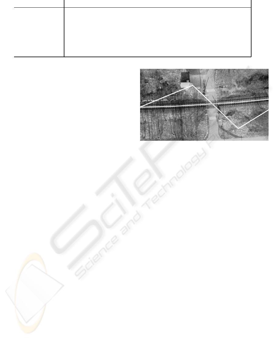
Table 1: User-definable data elements with floating-point vectors as geographic references in KML 2.2.
Data type Explanation
coordinates Triples of latitude, longitude and altitude values to define a point.
LonLatBox Top, bottom, left and right side of a bounding box and its rotation.
LonLatAltBox Just as LonLatBox, but includes the altitude of the bounding box.
LookAt/Camera Camera view on an object with 3D values for position and angles.
Orientation Rotation of a 3D model along the x-, y- and z-axes.
Location Location of a 3D model on the map.
ViewVolume Defines the field of vision for the current scene with angles as parameters.
placed far away from the building’s location in the
satellite image), the observer will raise alert.
• An algorithm could try to automatically map the
semantics of a user-defined object to those con-
tained in a database of reference objects. If
matches are found and the layout of the observed
object differs too much from the references, alert
may be triggered, too.
Consequently, the challenge is to embed such that nei-
ther of the above adversaries ever triggers alert. Be-
sides, we must also ensure that the stego objects are
valid and do not violate the above-mentioned statisti-
cal constraints.
4 STEGANOGRAPHICALLY
USABLE DATA IN KML FILES
The newest version of KML is 2.2 (Open Geospatial
Consortium Inc., 2007). The objects that users can de-
fine are, among others, placemarks, lines, paths, over-
lays, 3D models, and polygons. Each of them can
be equipped with a camera view, i. e., a set of pa-
rameters that determine how the user initially sees an
object. A numerical value, or digit vector, consists of
up to 16 digits to describe coordinates or angles and is
contained in special KML elements within the object
it describes. Note that, since modifiying digits in the
integer part seems critical to us, we only regard float-
ing point numbers for embedding, and of them only
those where a large number of decimal places is actu-
ally frequently used. We give a list of KML elements
with floating-point attributes that we consider suitable
for embedding in Tab. 1.
The size of the insignificant vector part in these
elements varies depending on the strength of the cor-
relation between digit vector and represented object,
if such a correlation at all exists. For instance, coor-
dinates of a polygon that confines a lake are all re-
lated to the lake’s shore, and mostly even to a certain
section of that shore. If, after embedding, these coor-
dinates jitter arbitrarily within 100 metres around the
Figure 2: Example for strange appearance of objects with
embedded message: The almost straight path marks a rail-
way track in the original version, while the zigzagged stego
version of the path fails to mark the track.
shore, this is unacceptable because the original mean-
ing of the shape is destroyed to a large extent. On
the other hand, if a camera position from which that
lake polygon is viewed jitters within the same range,
this usually is completely unsuspicious as long as the
polygon remains visible because the correlation be-
tween the lake and the camera position is less tight.
Figure 2 provides an example of a path that was al-
tered too much so that it is not correlated to the repre-
sented object anymore and thus looks quite strange.
Unfortunately, there is no formal way to precisely
identify the insignificant part of a digit vector in a cer-
tain KML element. As a consequence, defining the
number of digits per vector that can be replaced with
stego data is somewhat ad hoc. However, the very
same is also true for most steganographic algorithms
that work with the least significant bits of image pix-
els or DCT coefficients. We experimented with differ-
ent degrees of alterations and found that the embed-
ding capacities in Tab. 2 seem not to induce inappro-
priate changes and may thus be secure against detec-
tion. In that table, the number of digits replaced by
steganographic data is shown for the attributes used
in the KML elements of Tab. 1. The n exchanged dig-
its are always the n rightmost in the vector before the
last digit. The last decimal place is never changed (cf.
Sect. 6.3).
For instance, if all but seven decimal places for
GEOGRAPHIC DATA AND STEGANOGRAPHY - Using Google Earth and KML Files for High-Capacity
Steganography
383
Table 2: Embedding capacities of floating-point attributes
in KML, where #(x) denotes the count of x.
Floating-point attrs. Capacity in digits
north, east, south, west,
longitude, latitude, #(Decimal places)
rotation −7
altitude, heading, range,
minAltitude, maxAltitude
tilt, roll, topFov, leftFov, #(Decimal places)
bottomFov, rightFov, near −1
the north attribute are exchanged, and the given digit
vector is v = (d
0
, . . . , d
13
) with d
2
to d
13
as decimal
places, we can replace the five digits d
8
to d
12
with
steganographic data. If a north vector contains the
maximum of 16 digits, we can replace at most eight
digits because there is always at least one integer digit
and seven decimal places remain untouched.
For coordinate values which are measured in de-
grees of longitude or latitude, not using the first six
decimal places means that the changes caused by em-
bedding amount to at most 10
−6
degrees. According
to the definition of a degree of longitude and latitude
(cf. (Cox, 1999)), this equals about 11 centimetres.
In contrast, embedding starting at, say, the fifth deci-
mal place would be clearly insecure with a maximum
deviation of over 11 metres (Fig. 2 was created with
that maximum deviation).
With all other values that either describe angles or
distances in metres, such as tilt or altitude, we use all
but the last decimal place. This choice is justified as
follows: Angles are used to position the camera view
that is coupled to an object. However, this relation-
ship is quite loose. For example, it does not make any
difference to a user whether the tilt towards an ob-
ject is 85.562 or 85.982 degrees, which, in terms of
longitude and latitude, would be critical for the posi-
tioning of the object. The same is true for the altitude
in which an object is positioned. If the user decides
not to have an object clamped to the ground automat-
ically and chooses an unusual altitude like 2501.45
metres, changes to the decimal places will be unsuspi-
cious as well. However, changing digits in the integer
part might easily result in violation of the intentions
the user had when setting up the original view, so we
recoiled from that.
5 IMPLEMENTATION AND
PERFORMANCE
We implemented a stegosystem that subsequently re-
places numerical geodata in one or more KML files
with steganographic data as described in the previ-
ous section. The user types in an arbitrary message
or selects a hidden-message file
2
. The message is
Huffman-encoded with a given probability distribu-
tion that is optimised for English texts. In a second
step, the message is encrypted with AES intoa cipher-
text of n · 16 bytes before it is turned into an integer
value.
To embed the integer that represents the message,
the selected cover files are parsed and searched for
vectors suitable for embedding in a predefined order.
Now the algorithm splits up the message into short
strings that fit into the insignificant parts of the digit
vectors and overwrites the original data. As the re-
ceiver must distinguish the embedded data from other
random numbers, the first five replaced digits con-
tain the encrypted hidden-message length. For hidden
communication, sender and receiver need to share a
secret key and the stego file that is output by our al-
gorithm.
The most important performance criterion for a
stegosystem is how much data can be embedded with-
out compromising security. We empirically tested
the embedding capacity for KML files with different
numbers of paths, where each vertex in a path is re-
presented by a coordinate triple of latitude, longitude
and altitude values, and randomly selected excerpts
from Wikipedia articles in English. Because the alti-
tude values are 0 by default, they did not provide any
capacity in our test. Table 3 shows the results.
Table 3: Experimental capacities for KML files with path
objects consisting of between 100 and 1000 coordinate
triples of latitude, longitude and altitude values. The mes-
sage size refers to the original, i. e. uncompressed and un-
encrypted plain text.
Coord. File Message Ratio
triples size size
100 4,892 bytes 990 bytes 0.202
200 8,723 bytes 2,089 bytes 0.239
300 12,531 bytes 3,007 bytes 0.240
400 16,278 bytes 4,085 bytes 0.251
500 20,137 bytes 5,084 bytes 0.252
600 23,969 bytes 6,297 bytes 0.263
700 27,886 bytes 7,034 bytes 0.252
800 31,731 bytes 7,879 bytes 0.279
900 35,607 bytes 8,534 bytes 0.248
1000 39,549 bytes 9,723 bytes 0.246
The embedding capacity, i. e., the ratio between
file and message size, varies between 0.20 and 0.27,
depending on the degree of compression that the
2
Currently, as this is a proof-of-concept implementation,
only 8-bit character sets are supported.
SECRYPT 2008 - International Conference on Security and Cryptography
384
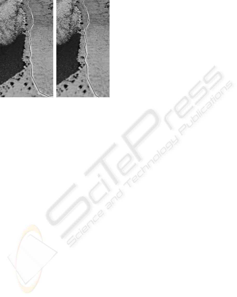
Figure 3: Embedding into a path that marks a trail right of
the shore of a lake (cover left, steganogram right).
Huffman encoding can achieve for the given text.
The AES encryption is also relevant for capacity to
some extent because the ciphertexts are n· 16 bytes in
length, thus causing jumps in capacity requirements
whenever n increases. Some constant amount of tex-
tual metadata that precedes the numerical data also
lowers the embedding capacity especially for small
numbers of vectors. Anyhow, with the values in Tab.
3, our system clearly outperforms the embedding ca-
pacities of current steganographic algorithms to em-
bed into JPEG images, such as OutGuess (Provos,
2001), F5 (Westfeld, 2001), MBS (Sallee, 2004), or
Perturbed Quantization (Fridrich et al., 2004). Fur-
thermore, Fridrich et. al. (Fridrich et al., 2007) esti-
mate that only less than 5 % of the non-zero AC coef-
ficients in JPEG images can be securely replaced by
stego data.
To give an example of the capability of our algo-
rithm, Fig. 3 contains the original version of a KML
path (black line) that marks a trail on the right side
of a lake and the steganogram with 576 bytes embed-
ded. If one looks carefully, one sees that the camera
position has slightly changed and that some pixels of
the path differ. However, the camera position is still
reasonable and the KML path never leaves the trail or
jitters around it. So, without knowledge of the origi-
nal cover, an attacker would hardly be able to detect
the steganogram as the images are nearly identical.
6 SECURITY ISSUES
Having identified the insignificant parts v
i
of the digit
vectors in KML files, we have to estimate the secu-
rity of our embedding method. This means that we
must find out, according to our statements in Sect. 3,
if our steganographic replacements v
′
i
obey the same
probability distribution as the original instances from
V
i
, given the significant data v
s
. Since the sequences
of digits that our algorithm outputs have a high de-
gree of randomness, we examined whether the data
found in KML files that were created by Google Earth
was equally random. We encountered some flaws and
biases in the data, produced by our system and by
Google Earth, which could lead to reliable detection
of steganograms. We will tackle them in the follow-
ing subsections. The effect of any measure taken to
counter such security problems is already included in
the performance figures presented in Tab. 3.
6.1 Digit Distribution
First, we examined the distribution of the digits in the
insignificant parts of the vectors. We assumed both
the original and our stego data to be uniformly dis-
tributed, i.e., all digits appear with about the same
probabilty. To verify this assumption, we generated
coverfiles with a total of more than 100,000 digits that
were suitable for embedding. We further used a sec-
ond, equivalent set of KML files to embed messages
that consumed between 50 and 100 % of the available
capacity. For both sets, we computed the digits’ prob-
ability distribution. The results can be seen in Fig.
4.
Obviously, there are only small deviations (below
1.5 %) from the expected uniformly distributed fre-
quencies for the digits, so we have no reason to be-
lieve that either cover or steganogram data is not uni-
formly distributed. We repeated this test separately
for the first, second and third digits in the insignifi-
cant vector parts with the same result. Therefore, the
overall distribution of the digits in a file does not seem
to provide an anchor for attacks.
6.2 Benford’s Law
Benford’s law (Benford, 1938) demands that the first
digit of a multi-digit number be not uniformly, but
logarithmically distributed. For the digits from 1 to
9, it implies that the first digit is 1 with about 30 %
probability, and 2 with only about 18 %. Finally, 9
occurs in the first place in somewhat less than 5 % of
the samples. Of course, 0’s are never first digits.
Figure 5 shows the empirically measured proba-
bility distributions for both the first and the second
digit of the stego data produced by our program as
well as for the first digit in the KML cover files be-
fore embedding. We found that the first digits we out-
put also obey Benford’s law, while the first digits of
GEOGRAPHIC DATA AND STEGANOGRAPHY - Using Google Earth and KML Files for High-Capacity
Steganography
385
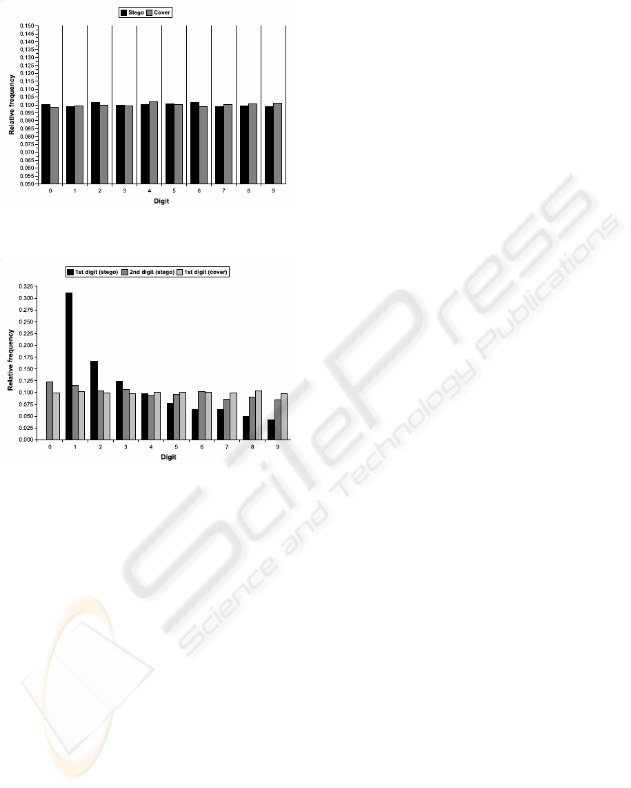
Figure 4: Probability distribution of the digits in cover and
stego file.
Figure 5: Probability distributionof the first and second dig-
its in stego data and the first digits in cover data.
the vectors in which the first digits of our messages
are embedded are uniformly distributed. The second
digits in our output are not uniformly distributed ei-
ther, though the bias is smaller. To fix this potential
insecurity, we apply a key-dependent random permu-
tation to the entire number that is produced by our
system. Thus, the bias in the distribution of the lead-
ing digits is spread over the whole hidden message
and vanishes.
6.3 Biased Values in Google Earth
While we were testing our algorithm, we experienced
a strange bias in Google Earth: If one types in an ex-
act coordinate value, this is often not stored as typed
but in- or decremented by some marginal quantum.
For example, when typing 50
◦
as latitude in a dialog
box, this value is likely to become 50.00000000001
◦
.
Since we assume that users will tend to hand over
exact coordinates to Google Earth, such values very
close to the next integer will occur with increased
probability due to the bias. In order not to distort their
distribution, our algorithm does not change them.
In case that two or more values are equal in a KML
file, there is a high probability that these values relate
to each other. For instance, these values could belong
to layered overlays. Therefore, we only replace one in
a couple of such values and set the others to the same
value such that the relationship is maintained.
Finally, we restrained from embedding in the least
significant digit of any value. The reason is that
with classical LSB embedding we risk to change the
probability distribution of the digit vectors’ lengths
throughout a file because trailing 0’s are cut by
Google Earth. This would also cause additional prob-
lems for the extraction of the embedded data.
6.4 Validity of the Generated Values
Data generated by our system would be easily dis-
coverable if it was invalid, i. e., if it contained digit
vectors v that Google Earth cannot generate. Since
we had no access to Google Earth’s source code, we
had no chance to directly look for impossible values.
Thus, we had to test empirically whether all values are
possible. In Google Earth, with the camera zoomed in
to the ground as close as possible, we created a large
set of placemarks with digit vectors v = (d
1
, . . . , d
n
),
where d
1
is the most significant digit and d
n
the least
significant digit in v. We then tried to create a vec-
tor v
′
= (d
1
, . . . , d
n
± 1). This was done by zooming
out in equidistant steps while keeping the position and
observing any changes to the vectors.
We found that with increasing camera height the
least significant vector digits began jittering around
the original values. In many cases, a vector v
′
as
above was found after some zooming so that we have
evidence that all theoretically possible values can ac-
tually be generated by Google Earth. However, we
could not check whether such v
′
can only be found un-
der certain side conditions. Anyhow, an attacker will
face the same problems when he tries to distinguish
original data and such generated by our program.
7 CONCLUSIONS
The steganographic algorithm we developed for em-
bedding in KML files can achieve significantly higher
capacities than those that are available for image-
based steganography. It is just as easy to use as other
current methods, and providing suitable KML cover
files is not more difficult than taking a picture. Al-
though we cannot proof it formally, we are confident
that the very small level of distortion that our algo-
rithm causes to the original data and the additional
SECRYPT 2008 - International Conference on Security and Cryptography
386

security mechanisms of Sect. 6 are enough to prevent
the attacks described in Sect. 3.
As far as the suspicion that the mere fact of us-
ing KML files for steganography might raise is con-
cerned, we believe that it will not be larger than with
exchanging images: Besides Google’s promotion of
the KML format, many websites have already spe-
cialised on distributing KML files. Therefore, no-one
will become a suspect just by frequently transmitting
KML files through a network.
However, one might argue that it is already possi-
ble to do steganography with Google Earth or other
GISes by adapting existing watermarking schemes
for geospatial objects such as polygons. But these
schemes have in common that their embedding capac-
ities are rather insignificant.
An overviewof embedding capacities for some re-
cent watermarking schemes based on 3D triangular
meshes can be found in (Wang et al., 2007). Although
the polygons we use are no meshes and only 2D, the
numbers stated there allow for some comparison. The
five schemes discussed in that paper offer capacities
between less than one bit and approximately one byte
per edge in a mesh, and the highest-capacity scheme
is already somewhat fragile.
In contrast (cf. Tab. 3), we can embed about ten
bytes per coordinate triple which corresponds to one
vertex in a polygon or mesh. Consequently, we can
conclude that our scheme is by far more suitable for
steganographic communications than those that were
initially designed for watermarking.
ACKNOWLEDGEMENTS
This work has been supported by the German Re-
search Foundation (DFG), grant GRK 1076/1. Fur-
thermore, thanks to the anonymous SECRYPT re-
viewers and to our colleagues at Oldenburg Univer-
sity that provided us with useful comments.
REFERENCES
Bazin, C., Le Bars, J.-M., and Madelaine, J. (2007). A
Blind, Fast and Robust Method for Geographical Data
Watermarking. In Proceedings on the 2nd ACM sym-
posium on Information, Computer and Communica-
tions Security, pages 265–272, Singapore.
Benford, F. (1938). The Law of Anomalous Numbers. In
Proceedings of the American Philosophical Society,
number 78, pages 551–572.
B¨ohme, R. and Westfeld, A. (2004). Breaking Cauchy
Model-Based JPEG Steganography with First Order
Statistics. In Samarati, P., Ryan, P., Gollmann, D.,
and Molva, R., editors, Computer Security ESORICS
2004. 9th European Symposium on Research in Com-
puter Security, volume 3193 of LNCS, pages 125–140.
Cox, A., editor (1999). Allen’s Astrophysical Quantities.
Springer-Verlag, 4th edition.
Doncel, V. R., Nikolaidis, N., and Pitas, I. (2005). Water-
marking Polygonal Lines Using an Optimal Detector
on the Fourier Descriptors Domain. In Proceedings of
2005 EURASIP European Signal Processing Confer-
ence, Antalya, Turkey.
Fridrich, J., Goljan, M., and Soukal, D. (2004). Perturbed
Quantization Steganography with Wet Paper Codes.
In Proc. ACM Multimedia Security Workshop, pages
4–15, Magdeburg, Germany.
Fridrich, J., Pevny, T., and Kodovsky, J. (2007). Statisti-
cally Undetectable JPEG Steganography: Dead Ends,
Challenges, and Opportunities. In Proceedings of the
ACM MM&S Workshop, pages 3–14, Dallas, USA.
Katzenbeisser, S. and Petitcolas, F., editors (2000). In-
formation Hiding. Techniques for Steganography and
Digital Watermarking. Artech House.
Open Geospatial Consortium Inc. (2007). KML 2.2 An
OGC Best Practice. Technical report.
Provos, N. (2001). Defending Against Statistical Steganal-
ysis. In Proceedings 10th USENIX Security Sympo-
sium, Washington, USA.
Sallee, P. (2004). Model-based Steganography. In Proceed-
ings of International Workshop on Digital Watermark-
ing, volume 2939, pages 154–167.
Wang, K., Lavou, G., Denis, F., and Baskurt, A. (2007).
Hierarchical Blind Watermarking of 3D Triangular
Meshes. In Proceedings of the IEEE International
Conference on Multimedia & Expo, pages 1235–1238,
Beijing, China.
Westfeld, A. (2001). F5 – A Steganographic Algo-
rithm: High Capacity Despite Better Steganalysis. In
Moskowitz, I. S., editor, Information Hiding. 4th In-
ternational Workshop, IH’01, pages 289–302.
GEOGRAPHIC DATA AND STEGANOGRAPHY - Using Google Earth and KML Files for High-Capacity
Steganography
387
