
A Contribution to an Image Mining Oriented
Geoprocessing
Renato Guadagnin
1
, Levy Santana
2
, Edilson Ferneda
1
and Hércules Prado
1
1
Universidade Católica de Brasília, Mestrado em Gestão do Conhecimento e da Tecnologia da
Informação, Campus II, SGAN 916 Norte, 70.790-160 Brasília, DF, Brazil
2
Universidade Católica de Brasília, Bacharelado em Fisioterapia, Campus I, QS 07, Lote 1
EPCT, 71.966-700 Águas Claras, Taguatinga, DF, Brazil
Abstract. Since its origin Geoprocessing Information Systems (GIS) are sup-
posed to deal with structured information concerned some geographical local-
ization. So one uses three-dimensional image representation systems in a huge
database, where it is possible to insert many data about some interest domain,
say, agriculture, economics, industry, demographics and so on. This article pre-
sents a new approach, which allows an integration of Geoprocessing and Image
Mining not only in typical geographical subjects but also in other domains such
as healthcare.
1 Introduction
Since its origin Geoprocessing Information Systems (GIS) are supposed to deal with
structured information concerned some geographical localization. So one uses matrix
or vector oriented three-dimensional image representation systems in a huge database,
where it is possible to insert many data about some interest domain, say, agriculture,
economics, industry, demographics and so on. Although maps are also an image
modeling technique, Geoprocessing is not usually a theme for image processing sci-
entific events, but for specific Geoprocessing concerned events.
Geoprocessing is a way to simplify the representation of an image, in order to sub-
sidize posterior analysis and eventual decisions. If one remembers that any decision
requires information and that images are the more concise way to present informa-
tion, one can derive the linkage between Geoprocessing and decision making. But the
way information is required for decision in not that one that in general comes directly
from Geoprocessing. The amount of information can be too high or it cannot be ade-
quately visible for decision makers.
In such context one can think about the benefits of Geoprocessing as a technique
to process different kinds of image, not only geographical. In any case image related
information generated by Geoprocessing becomes useful if it is suitably processed.
Here one can detect a wide research field for image mining
Guadagnin R., Santana L., Ferneda E. and Prado H. (2009).
A Contribution to an Image Mining Oriented Geoprocessing.
In Proceedings of the 2nd International Workshop on Image Mining Theory and Applications, pages 107-112
DOI: 10.5220/0001964701070112
Copyright
c
SciTePress

This article proposes the integration of Geoprocessing and Image Mining to support
decision making in different areas, such as healthcare and other areas that allow vis-
ual information modeling.
2 Geoprocessing Paradigm
There are four abstractions levels for Geoprocessing, say, the real, the conception, the
modeling and the implementation world. The real world concerns geographical data,
while the other ones mean gradually stated definition ways up to final information
output. These ways are strongly influenced by the features of geographical informa-
tion, such as cartographic methodologies and ground use forms [1].
Geoprocessing developed itself from theoretical geographical approaches. Idio-
graphic geography emphasizes form and place whereas nomothetic geography aims to
discover general processes [2]. Quantitative Geography looks for knowledge from
measurable features from different regions of the image by mainly using of Geostatis-
tics instruments. Critical Geography sees space as systems of actions and systems of
objects [3].
Information extraction from images requires all these approaches. For example, a
physician works idiographically and nomothetically when he analyses lesions and
abnormalities in an x-ray image. He uses Geostatistics with local visual samples to
soundly conclude about existence of some disease. Critical Geography is used when
he studies the influence of the functions of different organs based on its images and
additional data.
A more ambitious approach for Geoprocessing systems should emphasize the rela-
tions between image objects and its dynamic variations. This way they can become
effective information generation devices that allow computational knowledge extrac-
tion from quantitatively or qualitatively specifiable local contents of an image.
3 Image Mining Paradigm
Images are information mines, which car soundly support decision making [4]. Image
mining extracts implicit knowledge, image data relationship, or other patterns not
explicitly stored in the images [5]. Extraction of information must follow some basic
hypothesis and be oriented to some purpose. For instance, an x-ray picture can pro-
vide quite different information for orthopedics and for cardiology.
Image mining can also be very efficient with two-dimensional images. It can be
performed after a series gradual image processing or modeling techniques. Appar-
ently Image Mining is not directly concerned with Image Processing, but with mining
in ready images.
By introducing the unit area concept one can think of an image as a data base with
a lot of data concerning every local in the image. So information extraction proce-
dures will not work only based on pixel features. For example an image of skin with a
small dark region, could be much more useful if historical data about such spot where
computationally available.
108
4 Towards a Generalized Geoprocessing
By thinking of Geoprocessing (GP) as an image synthesizing technique and of Image
Mining (IM) as an image analyzing technique, one can imagine that IM should hap-
pen after GP. Interface requirements must so be stated in order to make it useful not
only for geographical imagery. An Image Mining Ontology could contribute to de-
velopment of robust systems for Image Mining based on Geoprocessing [6].
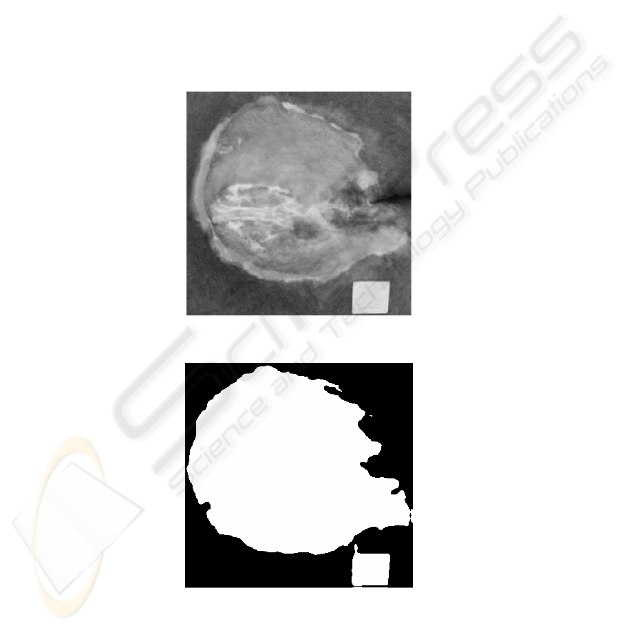
A recent pressure ulcer image analysis study through Geoprocessing software
Idrisi can be mentioned as an illustration [7]. Two-dimensional images were classi-
fied by means of Isoclust algorithm [8]. This is based on K-means classification that
iteratively attributes classes to all pixel up to achieving some limit criteria [8] [9]. The
area can be known through the pixel amount report concerning classified regions. See
Fig. 1 and 2.
Fig. 1. Original image with 4 sq cm pattern.
Fig. 2. Isoclust classified image after convolution with 9x9 mean mask.
109

This is part of a proposal that was presented in 1st IMTA that aimed to provide in-
formation for medical decisions based on pressure ulcer images and patient data [10],
Information extraction by Image Mining require that patients be typified and charac-
terized by means of group analysis techniques and supervised classification.
5 Main Steps to implement an Image Mining oriented Geoprocess-
ing System (IMOGS)
First it is necessary to gather information about image use for decision making by
means of process analysis in several domains. See Fig. 3. It will so be possible to
know
• decision supporting information,
• extractable information from images,
• image features,
• image processing requirements,
• sampling possibilities,
• image capture techniques, and
• the usual conventional activities to perform the whole process.
The results that the system will provide should be realistically defined. In Medicine,
for example, it is yet not possible to systematize many diagnosis based on images,
because they require additional knowledge. Such results will not be useful unless one
has available a user-friendly interface. Here the requirements for a multiple user
friendly interface must be defined.
Afterwards both image analysis techniques and image processing techniques can
be selected. One should take in account form and contents the image must have to
enable Image Mining. One should define procedures to transform row image data and
additional data that concern area units into new images. In such context very often
false colored images are built in Geoprocessing in order to enhance some desired
visual information.
Input related procedures must be flexible enough to enable image analysis from
different origins.
Now one has the necessary information for a prototype development that will be
validated. After feed-back and introducing of necessary adjustments in prototype,
IMOGS system can be developed and similarly validated. Finally IMOGS documen-
tation is written.
110
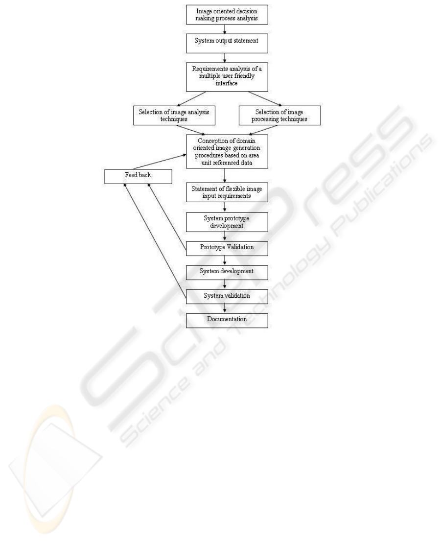
Fig. 3. System IMOGS development.
6 Final Remarks
It was not found any effort towards an integration of Geoprocessing and Image Min-
ing in the literature. Indeed Geoprocessing systems came in 1960s years and Image
Mining research appeared later at the end of 1990 decade [1] [11]. The implementa-
tion of here proposed construction of an IMOGS can accelerate the development of
Image Mining tools for practical goals.
A gradual approach seems more suitable, through first including one only domain in
order to acquire experience and reliable results, and so embracing more and more
domains. In accordance with this our research group is meanwhile engaged on medi-
cal image mining, mainly on pressure ulcers treatment information support.
111

References
1. Câmara, G., Davis, C., Monteiro, A.M.V. Introdução à Ciência da Geoinformação. São
José dos Campos, Brazil, INPE, (2001)
2. Zang, P.; Whinston, A. B., Business Information Visualization for Decision-Making Sup-
port – A Research Strategy. Proceedings of the First Americas Conference on Information
Systems, August 25-27, (1995), Pittsburgh, Pennsylvania
3. “Geographic Information Systems and Science”, Longley et. al. (Handouts)
4. Hsu, W; Lee, M.L.; Zhang, J.: Image Mining; Trends and Developments. Journal of Intelli-
gent Information Systems, Vol. 19, Issue 1, Kluwer Academic Publishers, Hingham, MA,
USA (2002) 7-23
5. Han, J. & Kamber, M.. Data Mining: concepts and techniques: Morgan Kaufmann, 2001.
6. Petrushin, V.A.; Khan, L.: Multimedia Data mining and Knowledge Discovery, Book
chapter: New Image Retrieval Principle: Image Mining and Visual Ontology. Springer
London (2007) 168-184
7. Pereira, I. L.; Souza, L. C.; Santana, L.; Guadagnin, R. V. . . Restoration of pressure ulcers
area detected by computational classification through image inclination correction. In:
PRIA-8-2007 8th International Conference on Pattern Recognition and Image Analysis,
2007, Yoskkar-Ola. Proceedings of the 8th International Conference on Pattern Recogni-
tion and Image Analysis. Yoshkar-Ola: Mari State Technical University, (2007). v. 1. p.
166-169.
8. Clark University. IDRISI Tutorial: 1987-2006.
9. Ohata AT, Quintanilha JA O uso de algoritmos de clustering na mensuração da expansão
urbana e detecção de alterações na Região Metropolitana de São Paulo, in: Anais do XII
Simpósio Brasileiro de Sensoriamento Remoto, Goiânia, Brasil, 16-21 de Abril de (2005),
INPE, p. 647-655.
10. Neves, R. S. ; Silva, S. F. ; Rocha Junior, E. F. ; Santana, L. ; Guadagnin, R. V. ; Ferneda,
E. . A proposal for automatic inference of pressure ulcers grade based on wound imagens
and patient data. In: First International Workshop on Image Mining, Theory and Applica-
tions, 2008, Funchal. Proceedings of the First Onternational Workshop on Image Mining
Theory and Applications. Setúbal : INSTICC Press, 2008. v. 1. p. 74-82.\January 21,
(2008).
11. Ordonez, C.; Omiecinski,E.R. Image Mining, a new approach for data mining, CC Techni-
cal Report; GIT-CC-98-12, Georgia Intitute of Technology, USA: (1998).
112
