
WEB-BASED AND CONTEXT-SENSITIVE, MOBILE
GEO-TOOLS TO SUPPORT SPATIAL DECISION MAKING
IN HEALTH AND EMERGENCY MANAGEMENT
Hardy Pundt, Thomas Spangenberg
Department of Automation and Computer Science, Harz University of Applied Sciences
Friedrichstr. 57-59, Wernigerode, Germany
Ronny Weinkauf
Brain SCC GmbH, Fritz-Haber-Straße 9, 06217 Merseburg, Germany
Keywords: GIS, Interoperability, Mobile GIS, Health management, Emergency management.
Abstract: The availability of reliable spatial information is often a prerequisite for rapid decision making in health-,
and emergency management. Meanwhile, there are many variations of “Geographical Information Systems”
(GIS) on the market, ranging from Desktop-GIS and Internet-based GI-services to various kinds of mobile
applications, the latter often localizing themselves via the GPS. The different forms in which GIS occur can
be used in various specific situations and for different problem-solving tasks. Some of these technologies
are introduced briefly, based on concrete examples from a running research project, called “GeoToolsHarz-
Advanced” (GOTHA). Some aspects that are worthwhile to be considered aiming at a better support for
health and emergency management through the application of spatial technologies are highlighted.
1 INTRODUCTION
Decision making in health- and emergency
management is based on spatial information in many
cases. On the one hand, health related issues concern
the spatial distribution of medical care stations,
hospitals, emergency facilities, and other related
entities. On the other hand, many problems occur
that concern the spatial relationships between such
entities. The "shortest" or "fastest" route between
private households and the next hospital, the
"nearest" specialized doctor, or pharmacy are
examples. Such relationships become significant
taking into account an aging society, where elder
people, for instance, aren’t necessarily able to
manage large distances to receive ambulatory care.
Both, the spatial distribution of medical facilities, as
well as the analysis of spatial relationships between
them, has to be seen in different spatial contexts
(local, regional, and smaller scales). Geographical
Information Systems (GIS) are an adequate means to
support the collection, analysis, and visualisation of
health related information. This is true concerning
the spatial distribution of health- and emergency-
relevant facilities, linked to fixed locations, as well
as the relationships between them. Furthermore,
mobile GI applications are able to track vehicles and
control how they can get to a place of accident or a
burning house on the fastest way, ideally taking into
account short-term traffic information and current
troubles caused by roads under construction and
similar issues.
This way, GIS in its various forms are effective
means to support decision making. Health-related
content, processed by desktop-, web based- or
mobile applications, can be used “indoors” and
"outdoors" and is therefore suitable to support a
complete digital information flow.
2 THE GOTHA PROJECT
In its current phase, the “GeoToolsHarz-Advanced
(GOTHA)”-project is aimed at the conceptualization
and prototypical realisation of webbased and mobile
GI applications to support route and travel planning.
469
Pundt H., Spangenberg T. and Weinkauf R. (2010).
WEB-BASED AND CONTEXT-SENSITIVE, MOBILE GEO-TOOLS TO SUPPORT SPATIAL DECISION MAKING IN HEALTH AND EMERGENCY
MANAGEMENT.
In Proceedings of the Third International Conference on Health Informatics, pages 469-472
DOI: 10.5220/0002754804690472
Copyright
c
SciTePress
Meanwhile, there are many route planners available
showing different characteristics and functionalities.
A basic deficit, however, is the lack of opportunities
to define individual criteria to modify route and
travel planning more exactly due to user
requirements. Different user groups have different
requirements which have to be taken into account
properly, but aren’t in many applications so far.
Furthermore it has to be recognized that such groups
are not homogenous in themselves. For instance, the
requirements of bikers in the age between 20 and 30
will be considerably different from those between 50
and 60 (Wilson and Curzon, 2006). This might
concern factors such as type of bike, pavement of
roads, preferences regarding length of trip, maximal
difference in altitude to be conquered, road-types
and landscape aesthetics. But also personal needs e.
g. shape and health of the individual are important
aspects. Such “subgroup”-specific requirements
should be taken into account, otherwise the
application will not fit the market needs (Pontikakis,
2007). As a consequence, services must provide
functionality that enables users to specify their
special needs, conditions, and desires. This is a
challenge for GUI programming, as well as the
implementation of functions to calculate the “right”
route under explicit consideration of user-specific
criteria (Richter and Duckham, 2008). However, the
goal is not to provide prepared, static routes but to
enable individual and dynamic planning of such
routes, almost enabling the user to modify plans due
to changed goal settings. This requires also to
combine the route-planning tool with other
information that could be helpful during a trip, e. g.
accommodation opportunities, public transportation,
restaurants, shops, pharmacies, surgeries, etc..
From 2006 – 2008 the state of Saxony-Anhalt in
Germany funded the “GeoToolsHarz” project as part
of the “competency centre for information- and
communication technologies, services, and tourism”
(KAT) at the Harz University of Applied Sciences in
Wernigerode (Rudert et al., 2008). Within this
project, a prototypical web-based geoportal has been
developed that couples data of public traffic
providers, as well as touristic information in a layer-
oriented manner. The entry point is built by a
topographical map, other information layers can be
overlayed easily. The application is developed using
web mapping services conform to the standards and
specifications of the Open Geospatial Consortium
(OGC 2009).
The project “GeoToolsHarz-Advanced
(GOTHA)” started in January 2009 and is
continuing the previous work under some new goal
settings. GOTHA is now based on a public-private-
partnership. The brain SCC GmbH Merseburg is
supporting the project financially due to the
identification of common approaches and goals. One
aim of the project is to bring the expertise of both
institutions together to achieve a more sophisticated
approach to user-centred applications.
One focus of GOTHA is, apart from the web
based application for route-planning, the mobile
component. Currently, tests are carried out with
different kinds of cell- and smartphones to provide
geographic information, combined with context-
sensitive information about the surroundings of a
user.
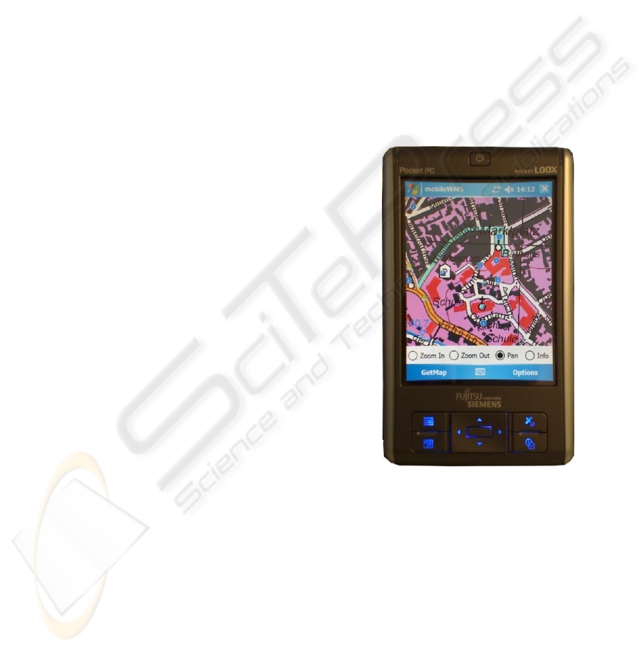
Figure 1 shows a prototypical implementation of
a web map service developed within GOTHA,
running on a cell phone and showing points-of-
interest in a city centre.
Figure 1: The mobile component of a webbased GI-
application, developed within the framework of the
GOTHA-project, showing points of interest (POI) in an
urban environment.
3 TRANSFORMATION
OF CONCEPTS TO NEW
APPLICATION AREAS
The results achieved so far indicate clearly that the
concepts developed in GOTHA can easily be
transformed to other application areas. Web
mapping services, for instance, can be used to
visualize the location of health- and emergency-
HEALTHINF 2010 - International Conference on Health Informatics
470
related facilities. On the one hand, they must be
made available for the Internet via standardized web
mapping services. On the other hand, they can be
transferred to a mobile GI-tool which enables the
user to explore maps for the best route from A to B
or to find the next pharmacy, surgery, hospital,
police- or fire station. Of course, current attributive
information, or content, must be linked to such
points-related objects. This way, the web GIS as
well as the mobile GIS give comprehensive
information that helps to make the right decision in a
concrete emergency situation or in case of a more or
less sudden occurrence of an illness (Figure 2). Such
tools are especially helpful in unknown areas. They
can be used by citizens, but also experts, such as
emergency helpers, firemen, and many other persons
confronted with healthcare- or emergency-cases.
They have to rely on such tools that allow access to
spatially referenced information wherever and
whenever they want.
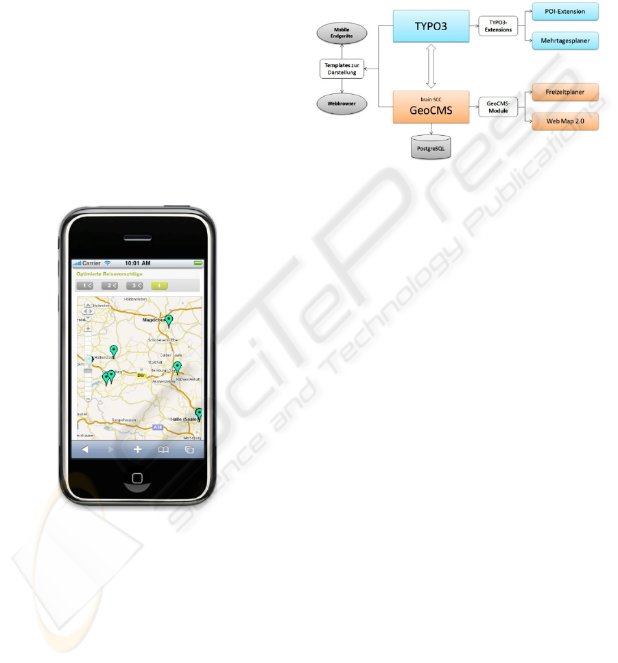
Figure 2: A variant based of the mobile tool, based on
another hard- and software platform; every POI enables
access to further content, e. g. healthcare- or emergency-
related information.
Figure 3 gives an overview of the current prototype
that underlies the GOTHA applications. It combines
a content management system (CMS) (Typo3 and
GeoCMS) to extract specific content for the web
application on the one hand, and the mobile
application on the other. On the right side the POI
extension, the route planner and other applications
are linked to the CMS. The mobile component,
however, gets further content due to its capability to
locate itself via GPS and therefore can give hints on
specific facilities near to the current location of the
user. In an emergency case, for example, this can be
the locations of the next surgery and a fast
calculation of the best way to the nearest doctor or
hospital, functionalities that provide automatically
urgently needed information to the user.
Figure 3: The content for the webbased and the mobile
application is, among other sources, extracted from a
Content Management System (CMS).
4 CONCLUSIONS
The results achieved so far are promising to achieve
the goal of more individual GI applications on the
one, and more sophisticated mobile applications on
the other hand. Users can easily access complete
content about health- and emergency specific
conditions in a rural or urban area.
Mobile GI tools, however, can provide the same
services. Additionally they can provide context-
sensitive information. If required, individual aspects
can be entered to get more user-centred results. Such
additional functionalities can be extremely helpful
especially in situations in which only little time is
given to search for relevant information (Pundt
2008). In emergency cases, however, such location
based, and context-sensitive tools as they are under
development in the GOTHA project, can represent
an important support.
ACKNOWLEDGEMENTS
The GOTHA project is supported financially by the
State of Saxony-Anhalt, and the brain SCC GmbH,
Merseburg, Germany.
WEB-BASED AND CONTEXT-SENSITIVE, MOBILE GEO-TOOLS TO SUPPORT SPATIAL DECISION MAKING
IN HEALTH AND EMERGENCY MANAGEMENT
471

REFERENCES
OGC, 2009. http://www.opengeospatial.org. (accessed
October 2009).
Pontikakis, E., 2007. Wayfinding in GIS: Formalization of
Basic Needs of a Passenger when using Public
Transportation. GeoInfoSeries (ed. by A. Frank),
Vienna 2007.
Pundt, H., 2008. The semantic mismatch as limiting factor
for the use of geoinformation in disaster management
and emergency response. In: Zlatanova, S., Li, J.
(eds.): Geospatial Information Technology for
Emergency Response. Taylor & Francis, London, pp.
243 – 256.
Richter, K.F., Duckham, M., 2008. Simplest instructions:
Finding Easy-to-Describe Routes for Navigation. In:
Cova, T., Miller, H, Beard, K., Frank, A., Goodchild,
M. (eds.): Geographic Information Science, Springer,
Berlin, pp. 274 – 289.
Rudert, F., J. Grohmann, H. Pundt, 2008. Standardised
Geospatial Information Services on Mobile Devices.
Proceedings 11
th
International Conference on
Geographic Information Science, AGILE 2008.
University of Girona, Spain, CD-ROM.
Wilson, J., Curzon, P., 2006. Older People’s Experiences
Route-planning. Proceedings of the British Computer
Society Annual Conference on Human Computer
Interaction: HCI 2006, Vol.2.
HEALTHINF 2010 - International Conference on Health Informatics
472
