
INTEGRATION OF SPATIAL TECHNOLOGIES AND
SEMANTIC WEB TECHNOLOGIES FOR INDUSTRIAL
ARCHAEOLOGY
Ashish Karmacharya
1,2
, Christophe Cruz
2
, Frank Boochs
1
and Franck Marzani
2
1
Institut i3mainz, am Fachbereich 1 - Geoinformatik und Vermessung Fachhochschule Mainz
Holzstrasse 36, 55116 Mainz, Germany
2
Laboratoire Le2i, UMR-5158 CNRS, UFR Sciences et Techniques, Université de Bourgogne
B.P. 47870, 21078 Dijon Cedex, France
Keywords: OWL, SWRL, Spatial analysis, Knowledge management, Ontology, Semantic web, Industrial archaeology.
Abstract: We propose a method that uses the advancement in spatial technologies from current database systems
within the Semantic Web Technologies in order to enrich and to populate the knowledge of a domain
defined in an OWL-DL ontology. The results of spatial operations and functions are used to populate and to
enrich ontologies with new individuals and new relationships. The advantage of spatial analysis within
Semantic Web technologies is the diversity of the functionalities provided by the combination of spatial
operations and the rule language of the Semantic Web (SWRL). This method is applied in the industrial
archaeology domain in order to enhance the knowledge management.
1 INTRODUCTION
Geometry has always been the dominant component
in any system related to an archaeological project.
The objects extracted on the excavation sites are
represented by using their geometries. This fact has
led to the assumption that a system related to such
projects is either a 3D object modeling system or
Geographic Information System (GIS), as they both
use object geometries and their relations with their
surroundings. However, in the whole process the
semantics of the geometric objects and their
relationships with the surroundings are neglected.
With the advancement of survey technologies, data
can be collected more accurately. On the one hand,
this has brought a great advantage in the analysis
process as we possess more and diverse data to
perform the precise analysis. On the other hand, it
has created difficulties in managing them with
existing database systems due to their size and
diversity. This issue is even more visible in an
industrial archaeology project. Indeed, the sites of
excavations are available for a very limited time
only and thus the data have to be collected and
stored in a very short time. In addition, the diversity
of the data makes the management of the
information with the existing database systems more
complex. Hence, a lot of research is done in the field
of data indexation and information retrieval in order
to reach the level where this vast amount of
information can be managed through the knowledge
defined by the archaeologists. Actually, the
knowledge about the objects excavated from the
sites can only be defined by the archaeologists.
Consequently we propose a method which is
adjusting the old methods while, at the same time,
taking advantage of the emerging cutting edge
technology. We propose in our method to retain the
storing mechanism with the existing database
management systems and to consider geometry as
one of the major data types. In addition we suggest
the use of a collaborative web platform based on
semantic web technologies and knowledge
management so that the information can be handled
by several archaeologists and technicians. The
platform will allow to store data during the
excavation and to manage it through the knowledge
acquired during the identification process.
Furthermore, it facilitates the collaborative process
between the archaeologists concerning the
generation of knowledge from the data sets. The
75
Karmacharya A., Cruz C., Boochs F. and Marzani F.
INTEGRATION OF SPATIAL TECHNOLOGIES AND SEMANTIC WEB TECHNOLOGIES FOR INDUSTRIAL ARCHAEOLOGY.
DOI: 10.5220/0002791300750080
In Proceedings of the 6th International Conference on Web Information Systems and Technology (WEBIST 2010), page
ISBN: 978-989-674-025-2
Copyright
c
2010 by SCITEPRESS – Science and Technology Publications, Lda. All rights reserved

main principle of our approach is the use of semantic
annotation to provide a semantic view on the data
sets. The shared ontology that defines an index on
the semantic annotations allows us to build a global
schema between the data sources. This global
schema allows us to annotate, index, search and
retrieve data and documents.
The semantic tool is being used in a wide range of
applications ranging from data integrations to
knowledge management. Given that, this is a
relatively new topic, so great amount of researches
have been conducted on the different aspects of this
technology. However, most of the research hardly
includes spatial information and if they do they are
primarily focusing on spatial data integration with
semantic technologies (Green, 2008). The
ArchaeoKM (Karmacharya, 2008) project aims at
the inclusion of the spatial data process within
Semantic Web technologies in order to not only
establish a comprehensive data integration process
between spatial data but to also combine the benefits
of spatial operations with the deductive reasoning
capabilities of OWL DL ontologies for a
comprehensive knowledge management. The benefit
of spatial analysis within Semantic Web
technologies lies in the diversity of the
functionalities provided by the combination of the
spatial operation and the rule language of the
Semantic Web.
In the following section, we will discuss the
technical background of the project. In section 3 we
will introduce the Web platform ArchaeoKM.
Section 4 focuses on the spatial facilitator. It
explains the spatial integration of functions and
operations concerning the enrichment of ontologies,
as well as the SWRL extension. The last section
concludes the paper.
2 BACKGROUND
The sharing of knowledge in archaeology and it
disseminate to the general public through wiki has
been discussed in (Costa, 2008). Likewise the use of
knowledge to build up a common semantic
framework has been discussed in (Kansa, 2008).
Research works exist in the field of archaeology, but
most of the research is carried out in other related
fields. The existing research focusses more on the
use of a common language for efficient
interoperability. The research project in (Kollias,
2008) concerns the achievement of syntactic and
semantic interoperability through ontologies and the
RDF framework in order to build a common
standard. Data integration through ontologies and
their relationships are discussed in (Doerr, 2008).
Although the work on semantic web and knowledge
management in the field of Information systems in
archaeology or related fields has made progress with
these research works, it remains a fact that they are
in a very preliminary phase today. In addition, these
projects concentrate more on how to achieve
interoperability with semantic frameworks and
ontologies. However, no research focuses on the
knowledge generation process and more specifically
on rules defined by archaeologists in order to build
up the system which will use, evaluate and represent
the knowledge of the archaeologists.
Industrial Archaeology is perhaps the best suited
field in archaeology on which to carry out our
research. Actually, Industrial Archaeological Sites
(IAS) are available for a very short time only. The
limited time available for the storage of the data is
one of the concerns we want to address here.
Moreover, the amount of data that has to be
collected in this short span is very large and diverse.
The ArchaeoKM project focuses their attention on
the site of the Krupp factory in Essen, Germany. The
200 hectares area was used for steel production
during the early nineteenth century and was
destroyed in the Second World War. Most of the
area has never been rebuilt and thus provides an
ideal site for industrial archaeological excavation.
The area will be used as a park of the ThyssenKrupp
main building in 2010. Actually, we are running out
of time as far as the collection of the data is
concerned. The first challenge consists in creating a
relevant data structure which helps to retrieve those
data efficiently. In addition, the amount of data that
has to be collected is huge, so the system has to be
able to handle a huge data set.
The nature of the data set generated during the
project is heterogeneous. As it can be seen, the
acquired data ranges from scanned point clouds from
terrestrial laser scanners to the floor plans of old
archives. The primary source of geometric
information is provided through a point cloud. The
point clouds have a resolution of 0.036 degrees and
are in the Gauss Krüger coordinate system, zone II
(GK II). This is the main data set used for the 3D
object modeling. Beside the point clouds, a great
amount of images are also collected during the
excavation. Most of the images are taken with a non
calibrated digital camera and, consequently, do not
contain any information about the referencing
system. Even though they do not contain any
referencing information, they posses vital semantic
information and can be used for the formulation of
WEBIST 2010 - 6th International Conference on Web Information Systems and Technologies
76

knowledge. However, photogrammetric flights take
place to acquire aerial images of the area. The aerial
images are processed to generate a digital
orthophoto with a resolution of 10 cm. The digital
orthophoto is again in the Gauss Krüger referencing
system (GK II). Furthermore, a huge amount of
archive data are collected. These data contain floor
plans, old pictures and other semantic information.
Likewise, the notes taken by archaeologists are also
important to acquire semantic information of the
findings. ArcGIS databases are also available
depending on the site and its nature. These databases
are in the GK II reference system. For our example,
this database gives an overview of the site and can
be overlayed with the orthophoto in order to identify
the interesting locations easily.
3 THE ARCHAEOKM
PLATFORM
ArchaeoKM is a Web platform which takes into
consideration an adjustment of the old methods and,
at the same time, takes advantage of the emerging
cutting edge technology. The system still proposes
to retain the storing mechanism with the existing
database management systems and to consider
geometry as one of the major data types. In addition,
we suggest the use of a collaborative Web platform
based on semantic web technologies (OWL, RDF,
SPARQL, SWRL) and knowledge management in
order to handle the information provided by several
archaeologists and technicians. ArchaeoKM includes
deductive rules defined by archaeologists on data of
excavated objects. The knowledge is stored in a
machine-readable format. Consequently, the
knowledge can be translated into a human-readable
format.
The Web based system ArchaeoKM has an
architecture divided into three major levels. Each
level has its own distinct functionality and is
interdependent with the others. The syntactic level
stores all the information that is excavated on the
site. As discussed earlier, information is either stored
in file formats like images or archive data or stored
in the Relational Database Management System like
archaeological notes or scanned/GIS data.
The semantic level allows the management of
generated knowledge. It is achieved through the
ontological structure set up by archaeologists.
Archaeologists are involved actively in this phase as
they are the ones best suited to provide entities and
their relationships needed to build up the domain
ontology. This level represents a bridge between
interpretative semantics in which users interpret
terms and operational semantics in which computers
handle symbols (Guarino, 1994).
The knowledge level represents the specification
of the knowledge of archaeologists concerning the
industrial findings. This level provides the user with
a graphical interface represented by Web pages in
order to display the generated knowledge. The pages
are interrelated and can be navigated according to
their relevancy.
Besides these three levels, the system architecture
contains a component that facilitates the knowledge
generation, update and validation through a spatial
perspective. This component called the “spatial
facilitator” is in charge of the spatial data analyses
and provides thus the result in order to enrich and to
populate the ontology. The ontology population
process is the activity of adding new instances to an
ontology. The ontology enrichment is the activity of
extending an ontology by adding new elements (e.g.
concepts, relations, properties, axioms) (Castano,
2007). The details of the component are given in the
next section.
4 THE SPATIAL FACILITATOR
This section highlights our approach to the
management of the spatial operations in order to
enrich and to populate our ontology. The ontology
schema of the ArchaeoKM platform is responsible
for maintaining a relation between the enrichment of
the ontology, with the corresponding individuals
which are the objects excavated from the site, and
their semantic annotations on the data and
documents. The ontology schema is also responsible
for reflecting the archaeological interpretations of
the objects through proper relationships between
different entities of the objects.
4.1 The Ontology Schema
The core of the schema is the concept “siteFeature”
which stores all the excavated objects. The basic
process behind the “ArchaeoKM” is very
straightforward. Archaeologists are responsible for
the indexation of the findings on the orthophoto.
Those findings are then enriched in the domain
ontology through respective objects. The spatial
facilitator covers also the adjustments carried out
within the ontology schema in order to incorporate
the spatial components. The ontology schema
represents the terminological definition. It is defined
INTEGRATION OF SPATIAL TECHNOLOGIES AND SEMANTIC WEB TECHNOLOGIES FOR INDUSTRIAL
ARCHAEOLOGY
77
with the OWL-DL language which is a description
logic language (Baader, 2003). Actually, it
represents the definition of concepts and roles which
are properties and relations between concepts.
The ontology schema in the ArchaeoKM platform
has to be adjusted in order to incorporate the spatial
functions and operations. In general, the spatial
operations and functions provided by the current
database system can be broadly categorized into two
categories – spatial processing functions and spatial
relationship functions. The first category represents
unary functions and the second represents binary
functions. The unary operations return the new
geometry itself whereas the binary operations return
the binary value. Figure 1 shows the two categories
of the spatial functions. By adding spatial relations
between site features (feat:siteFeature), archeologists
define a certain kind of knowledge concerning the
disposition of findings on the current site. For
instance, a knowledge specification about the
domain can be made as it exist a finding “oven” and
a finding “railway” that overlap a finding
“building”. It means that the building is a finding
“factory”. So, a concept “feat:factory” is defined as
a subclass of “feat:siteFeature” and with the
condition described previously. It can be easily
computed with the help of the 2D/3D annotations of
the indexes.
4.2 Enrichment of the Ontology
Schema by Adding Spatial
Operations
The two sets of spatial operations are represented
with two different approaches in the ontology
schema. The first set of spatial operations needs to
be treated as we treat the features excavated in the
concept “siteFeature” since they result in
geometries. This is achieved by introducing a new
concept “spatialAnalysis” with sub-concepts to
support such 2D and 3D operations. It is important
to define a property that represents the relationship
between the spatial concepts with the feature
excavated. It is defined through predicate
“hasSpatialAnalysis”.
The second set of spatial operations provides the
status of the particular relationship between two
objects. Such relationships are binary relationship
and they show whether there exists a particular
relationship between two objects or not. As these
relationships do not yield new geometry and they
perform much in similar line to the object
relationships, they are represented as a form of
object relationship. It is shown by
“hasSpatialRelAnalysis” and has both range and
domain as “siteFeature”. It is possible to perform
binary spatial operations between the objects of
“siteFeature” and “spatialAnalysis”. From this point,
it can be see that spatial information which defines
the knowledge of a domain can be added in the
ontology. In addition the properties and relationships
can be verified with the help of spatial database by
the spatial facilitator.
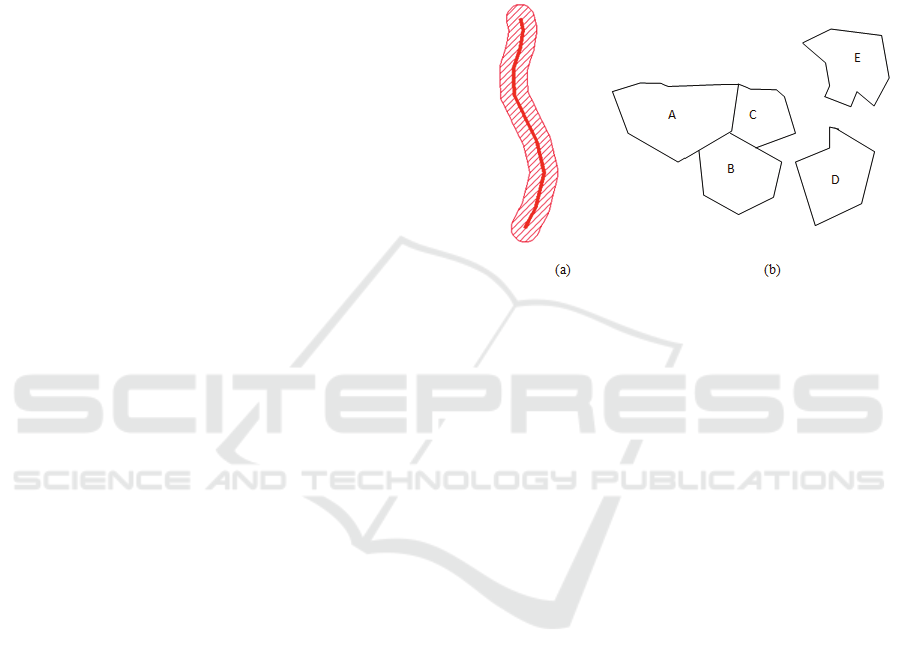
Figure 1: Two types of spatial operations (a) Buffering
(spatial processing) a linear feature (red linear feature)
generates crossed polygonal features around it (b) Five
polygons to demonstrate the touch (Spatial Relationship)
options – A touches B Æ true, A touches D Æ false.
In order to define the new spatial relationships
between individuals, any individual from the
concept “feat:siteFeature” has relationship to an
individual “shape:Feature” which can be 2D or a 3D
shape. Almost all of the existing database system
supports storage and retrieval of the spatial data with
their spatial extensions. They also support spatial
operations on these data. However the scales of
spatial operations vary from one database system to
another. They also vary in the support for the 3D
data set. Currently, there are not many 3D spatial
operations supported by the existing database
systems. Oracle 11g (Oracle, 2007) and PostGIS
1.3.5 (PostgresSQL, 2008) of PostgreSQL 8.3 are
the leading database systems supporting the 3D
operations. However such operations are mostly
limited to unary operations. ArchaeoKM intends to
use the advancements in spatial operations in
PostGIS to enrich the ontology. All the operations
are carried out in accordance to the SQL syntax of
the spatial operations of the database systems and
will be performed on the data stored in the database.
The results that are generated through such
operations are used to enrich the ontology. In this
manner, the database is merely used as the tool to
store the spatial data and to carry out the required
WEBIST 2010 - 6th International Conference on Web Information Systems and Technologies
78

spatial operations. The relationships and the results
are managed through the ontology.
4.3 The Extension of SWRL with
Spatial Analysis
This section presents the method used to integrate
the spatial operations (unary, binary, 2D and 3D
operations) with the help of Horn clauses (SWRL
language) in order to define knowledge on the
Industrial Archaeological Site (IAS) with ontologies
as well as rules.
Example of a SWRL expression. The following
example creates a new relationship
“cooperatedWith” between authors if they worked
on the same publication.
Publication(?a) ∧
hasAuthor(?a, ?y) ∧
hasAuthor(?a, ?z) ∧
differentFrom(?y, ?z)
→ cooperatedWith(?y, ?z)
In addition it exists “built-in” predicates in the
SWRL language that allow the computation of
advance information. For instance: Person(?p) ^
hasAge(?p, ?age) ^ swrlb:greaterThan(?age, 18) →
Adult(?p). The method presented in this section
consists in showing how can be extended the built-in
predicates with spatial operation.
Examples of a SWRL rule (Horn clauses) with a
spatial operation Buffer. The result is a new relation
between site feature x and y that satisfy the “buffer”
operation. Actually it consists to enrich the ontology
by adding a new relation between two individuals.
river(?x) ∧
Building(?y) ∧
archaeokm:Buffer(?x, ?y, 50)
→ isLiableToFlooding (?y)
oven(?x) ∧
Building(?y) ∧
archaeokm:Buffer(?x, ?y, 50)
→ hasOven(?y, ?x)
The spatial facilitator component in our
architecture is composed of an SWRL engine
improved with spatial operation predicates that
allow the definition of complex rules. In order to
realize these operations, each spatial operation is
converted to an SQL request. The example buffer
given is a combination of spatial operation Buffer
and “within”. The operation consists to define a SQL
query (e.g. next example). Thus, an SQL query has
to be defined for every SWRL operation in order to
process the expected result.
Example of a built-in operation converted into an
SQL request
SELECT y
FROM Ovenbb_tb
WHERE
within(the_geom,
buffer((
SELECT the_geom
FROM Ovenbb_tb
WHERE name = x),50)
)
4.4 An Example
This section presents a scenario to present our case
study. We are using the bounding boxes of five
distinct objects that are found in the industrial
archaeological site. Those findings are specialized
concepts of the concept “siteFeature”. These
concepts are “Oven”, “Railway”, “Structure”,
“Chimney”, “Pipeline” and “Plant”. Those concepts
represent the objects excavated.
Once the objects are excavated from the site, they
are used to enrich the ontology against their
respective concept. The geometries of these objects
are stored in the PostgreSQL database as the spatial
data type provided by PostGIS – spatial extension of
the database system.
To illustrate the spatial operations we discussed
in the previous sections, we take one operation from
each unary and binary spatial operation and
demonstrate how they enrich the ontology. To begin
with we take “Buffer operation” which buffers the
feature and is a unary operation. We define a buffer
of 50 meters around the “Oven_1” and populate the
ontology with a new specialized concept “Buffer” of
the concept “spatialAnalysis”. Then we populate this
concept with the corresponding object
“buffOven_1_50m” and store the resulted
coordinate.
Example of a spatial operation “buffer”.
SELECT AsText(
buffer((
SELECT the_geom
FROM Ovenbb_tb
WHERE name = 'Oven_1') ,50))
It is clear that when we specialize the concept
“spatialAnalysis”, a respective specialized object
property under “hasSpatialAnalysis” has to be
created too. In this case “hasBuffer” has to be
created under “hasSpatialAnalysis” simultaneously.
So the new RDF triplet from the operation above
would be (“siteFeature”, “hasBuffer”, “Buffer”).
The knowledge base is then populated with
“Oven_1” “hasBuffer” “buffOven_1_50m”.
INTEGRATION OF SPATIAL TECHNOLOGIES AND SEMANTIC WEB TECHNOLOGIES FOR INDUSTRIAL
ARCHAEOLOGY
79

The next operation is the binary operation and we
take as an example the “within” operation which
will show whether or not an object is contained in
the next one. This will generate binary results of the
operations. But to make this operation more
appropriate for our case, we modify the operation so
that it will extract all objects within the feature. The
spatial operation listed below will list out all the
features that are within the feature “Plant_1”.
Example of a spatial operation “within”.
SELECT name
FROM Ovenbb_tb
WHERE
within( the_geom,
(SELECT the_geom
FROM Ovenbb_tb
WHERE name = 'Plant_1')
))
The binary operations are used as the object
property “hasSpatialRelAnalysis” in the ontology. A
new specialized property “hasWithin” is created
with the RDF triplet as (“siteFeature”, “hasWithin”,
“siteFeature”). The knowledge base is then enriched
with these triplets (“Plant_1”, “hasWithin”,
(“Oven_1”, “Railway_1”, “Pipeline_1”, etc.)).
5 CONCLUSIONS
In this paper, the ArchaeoKM platform has been
presented by focusing on spatial analyses and by
showing the combination of these analyses with
Semantic Web technologies. These benefits are
materialized by the population and the enrichment
processes of a domain ontology with the help of
spatial operations using industrial archaeological site
data. An additional benefit is the extension of the
SWRL language by providing built-in “spatial
operations”. Thus, this extension allows the
definition of rules supplying new knowledge on the
IAS. These processes are managed by the spatial
facilitator component of the ArchaeoKM platform.
Although the case study uses industrial archaeology
for the description of the approach, it can be used in
other areas where the spatial data are the
predominant data type. Future work will be the
identification of all spatial operations that can be
handled by spatial database systems in order to offer
an overview of its capabilities. At the moment only
few of them are prototyped as a proof of concept.
REFERENCES
Baader, F., et al, 2003, The Description Logic Handbook –
Theory, Implementation and Applications, ISBN:
0521781760, Cambridge University Press, January
Castano, S., Espinosa, S., Ferrara, A., Karkaletsis, V.,
Kaya, a., Melzer, S., Moller, R., Montanelli S.,
Petasis, G., 2007. Ontology Dynamics with
Multimedia Information: The BOEMIE Evolution
Methodology, In Proc. of International Workshop on
Ontology Dynamics (IWOD) ESWC 2007 Workshop,
Innsbruck, Austria
Costa, S. and Zanini, E., 2008. Sharing knowledge in
archaeology: looking forward the next decade.
Digital Heritage in the New Knowledge Environment:
Shared spaces & open paths to cultural content, 31
October – 02 November in Athens, Greece
Doerr, M., 2008. The CIDOC Conceptual Reference
Model – A New Standard for Interoperability. Digital
Heritage in the New Knowledge Environment: Shared
spaces & open paths to cultural content, in Athens,
Greece
Green, J., Dolbear, C., Goodwin, J., 2008. Creating a
semantic Integration System using Spatial Data, 7th
International Semantic Web Conference (ISWC2008),
Karlshue, Germany, October 26-30
Guarino, N., 1994; The ontological level, in R. Casati B.
S. & White G., eds, Philosophy and the cognitive
sciences, Hölder-Pichler-Tempsky
Kansa, E. C., 2008. Opening Archaeology to Mash-ups:
Field Data and an Incremental Approach to Semantic,
Digital Heritage in the New Knowledge Environment:
Shared spaces & open paths to cultural content in
Athens, Greece
Karmacharya, A., Cruz, C., Marzani, F., Boochs, F., 2008.
Industrial Archaeology: Case study of Knowledge
Management for Spatial Data of Findings. 2nd
International Workshop on Personalized Access to
Cultural Heritage, in conjunction with 5th
International Conference on Adaptive Hypermedia and
Adaptive Web-Based Systems, Hannover, Germany
Kollias, S., 2008. Achieving Semantic Interoperability in
Europeana, Digital Heritage in the New Knowledge
Environment: Shared spaces & open paths to cultural
content, 31 October – 02 November in Athens, Greece
Oracle, 2007. Oracle Spatial Developer Guide 11g
Release, Oracle
PostgreSQL, 2008. PostGIS Manual, PostgreSQL
documentation
WEBIST 2010 - 6th International Conference on Web Information Systems and Technologies
80
