
THE ART OF MULTI-FACETED TAGGING
Interweaving Spatial Annotations, Categories, Meaningful URIs and Tags
Fabian Abel, Ricardo Kawase, Daniel Krause, Patrick Siehndel and Nicole Ullmann
IVS – Semantic Web Group & L3S Research Center, Leibniz University Hannover, Appelstr. 4, 30167 Hannover, Germany
Keywords:
Faceted tagging, Spatial tagging, Learning semantics.
Abstract:
In this paper we present TagMe!, a tagging and exploration front-end for Flickr images, which enables users
to attach tag assignments to a specific area within an image and to categorize tag assignments. We analyze the
differences between tags and categories and show how both facets can be applied to learn semantic relations
between concepts referenced by tags and categories. TagMe! automatically maps tags and categories to
DBpedia URIs to clearly define the meaning. In our experiments we compare different strategies to realize
such semantic mappings and show that already lightweight approaches map tags and categories with high
precisions (86.85% and 93.77% respectively). We further discuss how multi-faceted tagging helps to improve
the retrieval of folksonomy entities. The TagMe! system is currently available at http://tagme.groupme.org
1 INTRODUCTION
Tagging systems like Flickr or Delicious enable peo-
ple to organize and search large item collections by
utilizing the Web 2.0 phenomena: Users attach tags
to resources and thereby create so-called tag assign-
ments which are valuable metadata. However, impre-
cise or ambiguous tag assignments can decrease the
performance of tagging systems regarding search and
retrieval of relevant items.
For example a tag assignment, alloted to an image
may only describe a small part of an image and hence
cannot be used to derive the overall topic of the image
correctly. Some tag assignments are valid for a user-
specific point of view, e.g., a tourist would tag an im-
age of a landmark in a different way than a geologist.
And finally tag assignments suffer from ambiguity in
natural languages.
For disambiguation, approaches like MOAT (Pas-
sant and Laublet, 2008) exist, which support users
to attach URIs describing the meaning of a tag to
a particular tag assignment analogously to semantic
tagging in Faviki
1
. A more sophisticated approach,
which exploits Wikipedia and WordNet
2
to detect the
meaning of tags, is presented in (Marchetti et al.,
2007).
In this paper, we extend the common folkson-
1
http://faviki.com
2
http://wordnet.princeton.edu/
omy model by flexible, contextual tagging facets. We
present the TagMe! system that introduces novel tag-
ging facets: Tag assignments are enriched with a DB-
pedia URI (Auer et al., 2007) to disambiguate the
meaning of a tag. So-called area tags enable users
to tag a specific part of an image (spatial tagging).
Furthermore, a category dimension is offered to cate-
gorize tag assignments.
In the evaluation we show that users appreciate the
new tagging features. We present and examine dif-
ferent strategies to automatically map tags and cat-
egories to meaningful URIs. Further, we illustrate
how the different context facets can be exploited to
improve search and learn semantics among tags and
categories. For example, we show that the introduced
tagging facets are beneficial to identify similar tags
and to learn semantic relations between semantic con-
cepts referenced by the tags and DBpedia URIs.
The paper is structured as follows: In Section 2 we
introduce the TagMe! system and outline how to inte-
grate tagging facets in the user interface of a tagging
system and explain how to extend traditional tagging
models to offer additional tagging facets. The benefits
of the additional contextual information are evaluated
in Section 3. In Section 4 we discuss TagMe! with
respect to related tagging systems. Finally, Section 5
summarizes the advantages of the multi-faceted tag-
ging and gives an outlook on future work.
21
Abel F., Kawase R., Krause D., Siehndel P. and Ullmann N.
THE ART OF MULTI-FACETED TAGGING - Interweaving Spatial Annotations, Categories, Meaningful URIs and Tags.
DOI: 10.5220/0002793000210028
In Proceedings of the 6th International Conference on Web Information Systems and Technology (WEBIST 2010), page
ISBN: 978-989-674-025-2
Copyright
c
2010 by SCITEPRESS – Science and Technology Publications, Lda. All rights reserved
TagMe!
- categorization of tag assignments
- spatial tagging
- advanced semantics (e.g. DBpedia
mapping)
Faceted search and browsing
image retrieval
tag propagation
DBpedia URIs
Linked Data
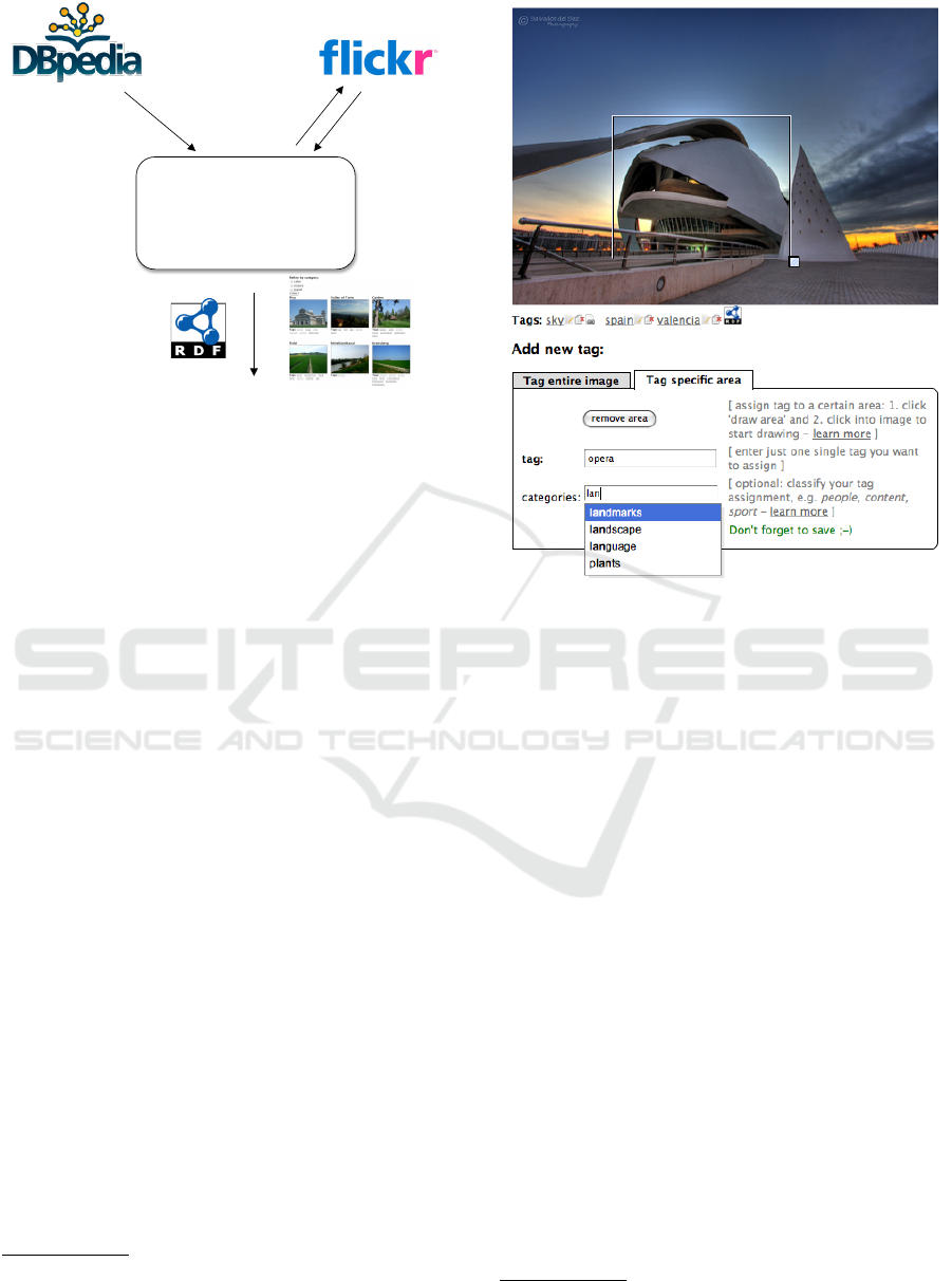
Figure 1: Conceptual architecture of TagMe!
2 TAGME! SYSTEM
TagMe! (Abel et al., 2009) is an online image tagging
system where users can assign tags to pictures avail-
able in Flickr. Figure 1 outlines the conceptual archi-
tecture of TagMe!, which can basically be considered
as an advanced tagging and search interface on top of
Flickr. Users can directly import pictures from their
own Flickr account or utilize the search interface to
retrieve Flickr pictures. If users tag their own images
in TagMe! then the tags are propagated to Flickr as
well. Moreover, TagMe! maps DBpedia URIs to tag
and category assignments by exploiting the DBpedia
lookup service
3
(cf. Section 3.3). Hence, all tags and
categories have well-defined semantics so that appli-
cations, which operate on TagMe! data, can clearly
understand the meaning of the tag and category as-
signments. The (meta-)data created in TagMe! is
made available according to the principles of Linked
Data (Berners-Lee, 2007) using the MOAT ontology
4
and Tag ontology
5
as primary schemata.
TagMe! extends the Flickr tagging functionality
in two further facets, specifically categories and area
tags. For each tag assignment the user can enter one
or more categories that classify the annotation. While
typing in a category, the users get auto-completion
suggestions from the pre-existing categories of the
user community (see bottom in Figure 2). TagMe!
users can immediately benefit from the categories as
TagMe! provides a faceted search interface that al-
lows to refine tag-based search activities by category
3
http://lookup.dbpedia.org
4
http://moat-project.org/ns
5
http://www.holygoat.co.uk/projects/tags
Figure 2: User tags an area within an image and categorizes
the tag assignment with support of the TagMe! system.
(and vice versa). Additionally, users are enabled to
perform spatial tag assignments, i.e. to attach a tag
assignment to a specific area, which they can draw
within the picture (see rectangle within the photo in
Figure 2) similarly to notes in Flickr or annotations in
LabelMe (Russell et al., 2008). When tagging, people
usually only tag the main content of the picture, giv-
ing less or almost none importance to supplementary
scenery images.
Area tags motivate the users to do so adding
significant semantic value to each annotated image.
Moreover, each spatial tag assignment has a globally
unique URI and is therewith linkable, which allows
users to share the link with others so that they can
point their friends and other users directly to a spe-
cific part of an image. For example, if users follow
the link of the spatial tag assignment “opera”
6
, shown
in Figure 2 then they are directed to a page where the
corresponding area is highlighted, which might be es-
pecially useful in situation where users discuss about
specific things within a picture. While the area tags
add an enjoyable visible feature for highlighting spe-
cific areas of an image and sharing the link to such
areas with friends, we consider them as highly valu-
6
http://tagme.groupme.org/TagMe/resource/403/tas/
1439
WEBIST 2010 - 6th International Conference on Web Information Systems and Technologies
22

able to improve search by detecting tag correlations
or to enhance the identification of similar tags (see
Section 3).
To express the introduced enhancements of the
TagMe! tagging system in a formal way, current folk-
sonomy models need to be extended.
2.1 Faceted Tagging
Formal models of a folksonomy are e.g. presented in
(Halpin et al., 2007; Mika, 2005). They are based on
bindings between users, tags, and resources. Accord-
ing to (Hotho et al., 2006) a folksonomy is defined as
follows:
Definition 1 (Folksonomy). A folksonomy is a
quadruple F := (U, T, R, Y ), where:
• U, T , R, are finite sets of instances of users, tags,
and resources, respectively, and
• Y defines a relation, the tag assignment, between
these sets, that is, Y ⊆ U ×T × R.
However, this simple folksonomy model is not
sufficient to describe the tag assignments in more de-
tail, i.e. assign context information to a tag assign-
ment. To allow users to create these different facets
of a tag assignment, we extend the given folksonomy:
Definition 2 (Faceted Folksonomy). A faceted
folksonomy is a tuple F := (U, T, R, Y, C, Z), where:
• U, T , R, C are finite sets of instances of users,
tags, resources, and context-information respec-
tively,
• Y defines a relation, the tag assignment that is,
Y ⊆ U × T × R and
• Z defines a relation, the context assignment that is
Z ⊆ Y ×C
In the TagMe! system, the context information can
be a) an area, b) a DBpedia URI or c) a category. All
context information are assigned to a tag assignment
by a relation Z.
By utilizing the additional information, tag assign-
ments become more connected to each other (see Fig-
ure 3). For example, two tags assigned to the same
area within an image or having the same DBpedia
concept can be considered as synonyms, while two
tags that are assigned to different areas in an image
are possibly not that strongly related to each other.
3 ANALYSIS AND BENEFITS OF
TAGME!
An analysis of the TagMe! data set reveals that the
users appreciate the multi-faceted tagging in TagMe!
Figure 3: The Faceted Folksonomy in the TagMe! system.
as 874 of the 1295 tag assignments, which were per-
formed within the three weeks after the launch of the
system, were categorized and 645 times the users as-
signed a tag to a specific area within a picture. Given
this initial data set, we analyzed the following ques-
tions.
• How are categories used in comparison to tags and
what are the benefits of categorizing tag assign-
ments?
• What are the benefits of assigning tags to specific
areas within an image (spatial tag assignments)?
• How accurate can tags and categories be mapped
to DBpedia URIs describing the meaning of the
annotations?
3.1 Analysis of Category Usage and
Benefits
Figure 4 shows the evolution of the number of distinct
tags and categories: Although categories can be en-
tered freely like tags, they grow much less than tags.
Further, only 31 of the 79 distinct categories (e.g.,
“car” or “sea”) have also been used as tags, which
means that users seem to use different kinds of con-
cepts for categories and tags respectively.
The TagMe! system supports users in assign-
ing categories by means of auto-completion (see Fig-
ure 2). During our evaluation we divided the users
into two groups: 50% of the users (group A) got only
those categories as suggestion, which they themselves
used before, while the other 50% of the users (group
B) got categories as suggestions, which were created
by themselves or by another user within their group.
This small difference in the functionality had a big
impact on the alignment of the categories. The num-
ber of distinct categories in group A was growing
61.94% stronger than in group B. Hence, the vocab-
ulary of the categories can be aligned much better if
categories, which have been applied by other users,
are provided as suggestions as well.
THE ART OF MULTI-FACETED TAGGING - Interweaving Spatial Annotations, Categories, Meaningful URIs and Tags
23
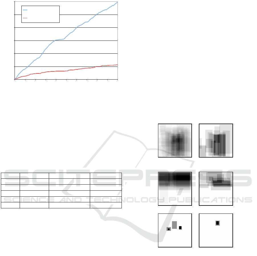
0
100
200
300
400
500
600
0 10 20 30 40 50 60 70 80 90 100
number of Tag Assignments in %
number of distinct Tags and Categories
distinct tags
distinct categories
Figure 4: Growth of number of distinct tags in comparison
to distinct categories.
Categories also enable to identify similar and re-
lated tags, which can, for example, be used for tag
recommendations or query expansion. The identifica-
tion of related tags is often based on tag co-occurrence
analysis, e.g. (Sigurbj
¨
ornsson and van Zwol, 2008),
i.e. two tags are related if they are often assigned to
the same resource.
Table 1: Identifying tags related to “clouds”.
Rank Tag-based Category-based Area-based
1 horse sky sky
2 sky field sun
3 tower river cloud
4 field snow cross
5 trees water sunset
Table 1 lists tags related to the tag “clouds”. Here,
the tag-based co-occurrence strategy does not per-
form that well as it also ranks tags such as “horse”
or “field” within as the top five most related tags. The
category-based strategy promotes basically those tags
to the top of the ranking that share the most categories
with “clouds”. For example, “sky” and “clouds” share
categories such as “nature” or “landscape”. In gen-
eral, the category-based strategy for detecting related
tags seems to work better. However, in the given ex-
ample, it still ranks the rather unrelated tag “field”
very high. In our experiments, the best results are pro-
duced by the area-based strategy, which refines the
category-based approach: It ranks those tags higher
that occur in spatial tag assignments, whose areas
overlap with the areas of the given tag. As shown
in Table 1, it also produces—in comparison to the
other strategies—the most reasonable ranking of tags
related to “clouds”. Four of the top five tags are appar-
ently related (“cross” seems to be the only exception).
From our initial experiments on identifying sim-
ilar tags, we draw the conclusion that tags, which
share the same category and are often assigned to
similar areas within an image (cf. area-based), are
closer related than tags that often co-occur at same re-
source. In our future work we will further investigate
whether our conclusion holds, especially in larger
datasets where categories might introduce noise as
they increase the overall connectivity of the folkson-
omy graph (cf. Figure 3).
3.2 Analysis of Spatial Tag Assignments
Categories can be differentiated according to their us-
age. For example, some categories have never or very
seldomly been used when a specific area of an image
was tagged (e.g., “time”, “location”, or “art”) while
others have been applied almost only for tagging a
specific area (e.g., “people”, “animals”, or “things”).
people friends
sky clouds
(i) categories
(ii) tags
sun moon
Figure 5: Annotated areas.
The areas, can moreover be used to learn relations
among categories and tags. Figure 5 shows (i) the ar-
eas that have been annotated whenever the categories
“people” and “friends” have been used (the darker an
area the more tags have been assigned to that area).
As the areas that have been tagged in both categories
strongly correlate and as category “people” was used
more often than category “friends” one can deduce
that “friends” is possibly a sub-category of “people”
even if both categories would never co-occur at the
same resource. Relations between tags can also de-
duced by analyzing the tagged areas. Figure 5 shows
(ii) the areas that were tagged with “sky”, “clouds”,
WEBIST 2010 - 6th International Conference on Web Information Systems and Technologies
24

“sun”, and “moon”
7
and via the size and position of
the area it is possible to learn that an entity is part
of or contained in another entity (e.g., “sun, moon,
and clouds are contained in sky”). The learned rela-
tions among tags and categories can moreover be used
to learn and refine relations between URIs (ontology
concepts) as TagMe! maps tags and categories to DB-
pedia URIs.
3.3 Mapping to DBpedia URIs
For realizing the feature of mapping tags and cate-
gories to DBpedia (Auer et al., 2007) URIs we com-
pared the following two strategies.
DBpedia Lookup. The naive lookup strategy in-
vokes the DBpedia lookup service with the
tag/category that should be mapped to a URI as
search query. DBpedia ranks the returned URIs
similarly to PageRank (Bizer et al., 2009) and our
naive mapping strategy simply assigns the top-
ranked URI to the tag/category in order to define
its meaning.
DBpedia Lookup + Feedback. The advanced map-
ping strategy is able to consider feedback while
selecting an appropriate DBpedia URI. When-
ever a tag/category is assigned, for which already
a correctly validated DBpedia URI exists in the
TagMe! database then that URI is selected. Oth-
erwise the strategy falls back the naive DBpedia
Lookup.
0
10
20
30
40
50
60
70
80
90
100
Dbpedia Lookup Dbpedia Lookup +
Feedback
Dbpedia Lookup Dbpedia Lookup +
Feedback
tags categories
precision
Figure 6: Precision of mapping tags and categories to DB-
pedia URI.
Figure 6 shows the accuracy of both strategies.
The mappings of the naive approach result in a pre-
cision of 79.92% for mapping tags to DBpedia URIs
and 84.94% for mapping categories. The considera-
tion of feedback improves the precisions of the naive
7
The visualizations are based on 25 (“sky”), 10
(“clouds”), 6 (“sun”), and 2 (“moon”) tag assignments re-
spectively.
DBpedia Lookup clearly to 86.85% and 93.77% re-
spectively, which corresponds to an improvement of
8.7% and 10.4%. As the mapping accuracy for cat-
egories is higher than the one for tags, it seems that
the identification of meaningful URIs for categories
is easier than for tags. In summary, the results of the
DBpedia mapping are very encouraging. Moreover,
the precision of the category mappings, which are de-
termined by the strategy that incorporates feedback,
will further improve, because—fostered by TagMe!’s
category suggestion feature—the number of distinct
categories seems to converge (cf. Figure 4). Further,
the mapping strategies can be enhanced by also con-
sidering the context of the tag/category that should be
mapped. For example, for mapping a tag assignment
one could select the DBpedia URI, which best fits to
the DBpedia URI of the category that is associated to
the tag assignment. Implementation of such advanced
mapping strategies is part of our future work.
The DBpedia mapping reduces the number of
distinct tags and categories within TagMe! by
14.1% and 20.9% respectively, which has a posi-
tive impact on the recall when executing tag-based
search. For example, while some users assigned
the tag “car” to pictures showing cars other users
chose “auto” to annotate other pictures that show
cars. As both kinds of tag assignments are mapped
to “http://dbpedia.org/resource/Automobile”, TagMe!
can simply search via the DBpedia URI whenever
users search via “car” or “auto” to increase recall of
the tag-based search operations.
3.4 Synopsis
The two tagging facets, categories and areas, which
are applied in TagMe! also have a positive impact
on the retrieval of folksonomy entities such as search-
ing for resources or receiving tag recommendations
as those facets can be applied to detect correlations
between the entities. For example, tag recommen-
dations are usually based on tag co-occurrence, e.g.
if different tags are often assigned to same resources
then they can be considered as tag pair and whenever
one of the tags occurs at some resource it is likely that
the other tag is relevant for that resource as well. By
exploiting the category facet, TagMe! can increase
the number of such tag pairs by 367%. Further, the
category dimension has potential to compute the sim-
ilarity of two tags more precisely, e.g. in addition to
the (relative) number of times two tags occur at same
resources one can consider the (relative) number of
times these tags have been used in the same category.
The areas of tag assignments can be exploited simi-
larly to refine the correlations between tags. The anal-
THE ART OF MULTI-FACETED TAGGING - Interweaving Spatial Annotations, Categories, Meaningful URIs and Tags
25

ysis of the size, position, and overlap of areas more-
over promises to improve the quality of search and
ranking.
The results of our analyses can be summarized as
follows.
• The usage of categories differs from the usage of
tags: Even for those users, who did not benefit
from the category suggestions, the number of dis-
tinct categories is growing slower than the number
of distinct tags.
• Categories are used to further describe and clas-
sify tag assignments, and allow the user to solve
the problem of ambiguous tags.
• Categories and area tags enhance the connectivity
of the folksonomy and provide big potential to im-
prove search or recommender applications (e.g.,
categories in TagMe! increase the co-occurrence
rate of tags 367%).
• For identifying related tags, tag assignments en-
riched with category and area facets are a more
valuable source of information than traditional tag
assignments: Tags, which share the same cat-
egories and are often assigned to similar areas
within an image, are closer related than tags that
simply co-occur at same resources.
• The spatial tag assignments can be used to learn
typed relations among tags and categories such
as sub-category, sub-tag, part-of, or contained-
in relations. As tags and category assignments
are mapped to meaningful URIs (ontological con-
cepts), it is possible to propagate the learned rela-
tions to ontologies.
• A naive DBpedia lookup allows us to map tags
and categories to ontological concepts (DBpedia
URIs) with a high precision of 79.92% (tags) and
84.94% (categories).
• The consideration of feedback improves the ac-
curacy of the mapping of tags and categories to
86.85% and 93.77% respectively.
• The DBpedia mapping reduces the number of dis-
tinct tags and categories and can therewith be used
to improve recall of tag-based search.
Those findings motivate to exploit the different
facets embedded in faceted folksonomies (cf. Defi-
nition 2.1) such as the TagMe! folksonomy. In our
future work we will analyze the impact of those facets
on search and ranking.
4 RELATED WORK
The analyses in the previous section revealed sev-
eral technical advantages of the tagging facets avail-
able in the TagMe! system. In this section we
compare the tagging and tag-based exploration fea-
tures of TagMe! from the perspective of the end-
users with other tagging systems: Flickr, Delicious,
Faviki (Milicic, 2008) and LabelMe (Russell et al.,
2008). Our comparison among the systems is par-
tially based on the dimensions of the tagging system
design taxonomy developed in (Marlow et al., 2006).
For example, we compare the (i) “Tagging rights”,
(ii) “Tagging support” and (iii) “Aggregation model”
of those systems. These characteristics define respec-
tively (i) who can tag, (ii) if the user gets assistance
from the system during the tagging process and (iii)
whether the system allows users to assign the same
tag more than once to a particular resource (aggrega-
tion model = bag) or not (aggregation model = set).
We extend the tagging design taxonomy with the
following additional dimensions related to tagging.
Semantic Tagging. We consider tagging as semantic
tagging whenever the meaning of a tag is clearly
defined, for example, by attaching a URI explain-
ing the meaning of the tag (Passant and Laublet,
2008).
Spatial Tagging. The practice of annotating a spe-
cific piece of a resource, e.g., parts of an image
or paragraphs in a text.
Tag Categorization. A method enabling users to
categorize or classify the tags and tag assign-
ments.
Further, we introduce two dimensions that char-
acterize to which degree users can exploit the tags to
retrieve resources within the system.
Tag-based Navigation. Not all systems that provide
tagging functionality also allow their users to ex-
plore and browse content based on tags, e.g. initi-
ating search by clicking on a tag.
Faceted Navigation. By faceted navigation, we
mean the feature of filtering resources based on
the different dimensions of a tag assignment, i.e.
by user, tag, or resource, category, or area (cf.
Folksonomy model, Section 2.1). For example, in
Delicious people can navigate through bookmarks
annotated with specific tags (tag dimension) by a
specific user (user dimension).
Table 2 summarizes the characteristics of TagMe!
and similar tagging systems according to the taxon-
omy explained above.
The social bookmarking system Faviki and
TagMe! are the only systems listed in Table 2 that
WEBIST 2010 - 6th International Conference on Web Information Systems and Technologies
26

Table 2: TagMe! system characteristics in comparison to other social tagging and annotating systems.
Dimension/System Flickr Delicious Faviki LabelMe TagMe!
Semantic tagging no no yes no yes
Spatial tagging no no no yes yes
Tag categorization no tag bundles no no tas categorization
Tagging support viewable suggested suggested viewable suggested
Tagging rights permission-based free-for-all free-for-all free-for-all free-for-all
Aggregation model set bag bag bag bag
Tag-based navigation yes yes yes no yes
Faceted navigation yes (user, group) yes (user) yes (user) no yes (user, category)
allow for semantic tagging. Both systems primarily
map tag assignments to DBpedia URIs (Bizer et al.,
2009). Faviki requests the end-users to explicitly se-
lect the appropriate URIs while TagMe! is doing the
mapping automatically. A fundamental restriction of
Faviki is that only those tags, which correspond to
a meaningful URI, can be assigned to a bookmark.
Faviki supports users with a list of URI suggestions
from which the users have to select one URI. Deli-
cious and TagMe! provide tagging support by means
of auto-completion. Flickr and LabelMe, which is an
online annotation tool for images, do not provide tag
suggestions but tags already assigned to a resource are
viewable when adding new tags. In Flickr, users are
not allowed to assign the same tag more than once to
a particular resource (aggregation model = set) and
moreover the owner of a picture has to grant oth-
ers the permission to tag the picture (tagging rights:
permission-based) which results in so-called narrow
folksonomies (Vander Wal, 2005). In contrast, the
other systems listed in Table 2 do not impose these
restrictions which allows for broad folksonomies.
TagMe! provides two tagging features that are
currently not sufficiently implemented in other sys-
tems: spatial tagging and tag categorization. Flickr
and also MediaWiki
8
platforms enable users to add
notes or comments to specific areas within pictures.
However, similarly to LabelMe, which allows users to
attach keywords to arbitrarily formed shapes within
an image, these systems do not provide means for
tag-based navigation based on such spatial annota-
tions, i.e. users cannot click on a spatial tag assign-
ment to navigate to other resources that are related
to the corresponding tag (and possibly to the area).
TagMe! offers tag-based navigation, which is com-
mon in tagging systems such as Flickr and Delicious,
also for spatial tag assignments. A further innovation
of TagMe! is the tag categorization that is performed
on the level of tag assignments (tas categorization)
and can therewith be used to disambiguate the mean-
ing of a particular tag assignment (cf. Section 3).
8
http://www.mediawiki.org
Delicious, on the contrary, only supports grouping of
tags in so-called tag bundles. These tag bundles en-
able users to organize tags but do not help them to dis-
ambiguate specific tag assignments. They are more-
over seldomly used: Tonkin reports that approx. 10%
of the Delicious users have more than five tag bun-
dles (Tonkin, 2006).
The structure of folksonomies (see Section 2.1)
can be exploited to navigate through the resource
corpus of a tagging system with respect to different
facets. For example, when clicking on a tag in Flickr
to explore related pictures, users can filter the results
to narrow down the results to pictures of a specific
user or pictures that occur in a specific group of pic-
tures. In addition to the feature of browsing resources
in context of specific users—as possible in Flickr, De-
licious, and Faviki—TagMe! allows such tag-based
faceted navigation by applying the categories of tag
assignments as filters.
5 CONCLUSIONS
In this paper we discussed multi-faceted tagging in the
TagMe! system. TagMe! is a tagging and exploration
interface for Flickr and enables users to (1) categorize
their tag assignments and (2) attach tag assignments
to a specific area within an image. Moreover, all tag
assignments are mapped to DBpedia URIs that de-
scribe the meaning of the tag. Our analyses reveal that
strategies, which exploit categories and spatial tag as-
signments, provide better results in detecting simi-
lar or related tags than naive tag-based co-occurrence
strategies. Further, both facets can be exploited to au-
tomatically learn new relations among tags and cat-
egories (e.g., contained-in or sub-tag) and therewith
also among the corresponding DBpedia URIs. Our
feedback-based mapping strategy is able to map tag
and category assignments with a precision of more
than 85% and 90% respectively to the correct URIs.
The DBpedia mapping itself has the potential to in-
crease the precision and recall of search in tagging
THE ART OF MULTI-FACETED TAGGING - Interweaving Spatial Annotations, Categories, Meaningful URIs and Tags
27

systems as it solves the problem of ambiguous as well
as synonymous tags. The new tagging facets give
the users new means to navigate through images and
further allow for advanced search and ranking algo-
rithms.
In our future work we will examine whether it is
possible to learn more fine-grained relations by con-
necting the semantic tags and categories in TagMe!
with external domain ontologies. For example, if two
objects within the same image are tagged with person
or friend (spatial tagging) one could assume that there
is a foaf:knows relation between both persons. Fur-
ther, we will analyze the impact of spatial tagging on
search and try to answer whether the size of a tagged
area matter or whether the proximity of the tagged
area is relevant to the midpoint of the picture. To ex-
plore these research questions on larger data sets, we
would like to integrate the TagMe! tagging features
into an other photo sharing platforms such as Arsme-
teo (http://www.arsmeteo.org).
REFERENCES
Abel, F., Kawase, R., Krause, D., and Siehndel, P. (2009).
Multi-faceted Tagging in TagMe! In 8th International
Semantic Web Conference (ISWC2009).
Auer, S., Bizer, C., Kobilarov, G., Lehmann, J., Cyga-
niak, R., and Ives, Z. (2007). DBpedia: A Nucleus
for a Web of Open Data. In et al., A., editor, The
Semantic Web, 6th International Semantic Web Con-
ference (ISWC), 2nd Asian Semantic Web Conference
(ASWC), pages 715–728.
Berners-Lee, T. (2007). Linked Data - design issues. Tech-
nical report, W3C. http://www.w3.org/DesignIssues/
LinkedData.html.
Bizer, C., Lehmann, J., Kobilarov, G., Auer, S., Becker, C.,
Cyganiak, R., and Hellmann, S. (2009). Dbpedia - a
crystallization point for the web of data. Web Seman-
tics: Science, Services and Agents on the World Wide
Web.
Halpin, H., Robu, V., and Shepherd, H. (2007). The Com-
plex Dynamics of Collaborative Tagging. In Proc. of
16th Int. World Wide Web Conference (WWW ’07),
pages 211–220, New York, NY, USA. ACM Press.
Hotho, A., J
¨
aschke, R., Schmitz, C., and Stumme, G.
(2006). BibSonomy: A Social Bookmark and Pub-
lication Sharing System. In Proc. First Conceptual
Structures Tool Interoperability Workshop, pages 87–
102, Aalborg.
Marchetti, A., Tesconi, M., Ronzano, F., Rosella, M., and
Minutoli, S. (2007). SemKey: A Semantic Collab-
orative Tagging System. In Workshop on Tagging
and Metadata for Social Information Organization at
WWW ’07, May 8-12, 2007, Banff, Canada.
Marlow, C., Naaman, M., Boyd, D., and Davis, M. (2006).
HT06, tagging paper, taxonomy, flickr, academic arti-
cle, to read. In Proc. of the 17th Conf. on Hypertext
and Hypermedia, pages 31–40. ACM Press.
Vander Wal, T. (2005). Explaining and show-
ing broad and narrow folksonomies.
http://www.personalinfocloud.com/2005/02/
explain ing and .html.
Mika, P. (2005). Ontologies Are Us: A unified model of
social networks and semantics. In Proc. Int. Semantic
Web Conference (ISWC 2005), pages 522–536.
Milicic, V. (2008). Case study: Semantic tags. W3C
Semantic Web Case Studies and Use Cases.
http://www.w3.org/2001/sw/sweo/public/UseCases/
Faviki/.
Passant, A. and Laublet, P. (2008). Meaning Of A
Tag: A collaborative approach to bridge the gap be-
tween tagging and Linked Data. In Proceedings of
the WWW 2008 Workshop Linked Data on the Web
(LDOW2008), Beijing, China.
Russell, B. C., Torralba, A. B., Murphy, K. P., and Freeman,
W. T. (2008). LabelMe: A Database and Web-based
tool for Image Annotation. International Journal of
Computer Vision, 77(1-3):157–173.
Sigurbj
¨
ornsson, B. and van Zwol, R. (2008). Flickr tag rec-
ommendation based on collective knowledge. In Proc.
of 17th Int. World Wide Web Conference (WWW ’08),
pages 327–336. ACM Press.
Tonkin, E. (2006). Searching the long tail: Hidden struc-
ture in social tagging. Proceedings of the 17th SIG
Classification Research Workshop.
WEBIST 2010 - 6th International Conference on Web Information Systems and Technologies
28
