
AD-HOC GEOREFERENCING OF WEB-PAGES USING
STREET-NAME PREFIX TREES
Andrei Tabarcea
Faculty of Automatic Control and Computer Engineering, Technical University of Iaşi, Romania
Ville Hautamäki
Institute for Infocomm Research, A*STAR, Singapore
Pasi Fränti
Speech and Image Processing Unit, University of Eastern Finland, Joensuu, Finland
Keywords: Search engine, LBS, Database, Prefix tree, Georeferencing, Mobile device, Location information, Personal
navigation, WWW.
Abstract: A bottleneck of constructing location-based web searches is that most web-pages do not contain any explicit
geocoding such as geotags. Alternative solution can be based on ad-hoc georeferencing which relies on
street addresses, but the problem is how to extract and validate the address strings from free-form text. We
propose a rule-based solution that detects address-based locations using a gazetteer and street-name prefix
trees created from the gazetteer. We compare this approach against a method that doesn’t require a gazetteer
(a heuristic method that assumes that street-name has a certain structure) and a method that also uses data
structures created from the gazetteer in the form of street-name arrays. Experiments using our location
based search engine prototype (MOPSI) for Finland and Singapore, show that the proposed prefix-tree
solution is twice as fast and 10% more accurate than its rule-based alternative and 10 times faster if an array
structure is used when accessing the gazetteer.
1 INTRODUCTION
Location-based services (LBS) have become popular
during recent years due to increasingly wide
availability of GPS positioning in multimedia
mobile phones. For instance, according to Nokia’s
own estimate more than half of their phones would
include GPS by 2010-2012. In case of lacking GPS,
positioning can also be based on cellular network or
even on IP address for rough estimation. It is
therefore expected that location-based services are
emerging very fast to our everyday life via mobile
phones and other consumer electronics.
Locations-based services such as YellowPages
1
,
Google Maps
2
and Nokia Ovi Services
3
are
1
http://en.02.fi/yellow+pages/
2
http:/maps.google.com/
3
http://www.ovi.com/services/
traditionally based on databases where all entries
have been explicitly georeferenced when stored in
the database. An alternative approach has been
outlined in (Hariharan et al., 2002) and (Fränti et al.,
2010) based on web search and using ad-hoc
georeferencing of the web-pages. We denote this
approach as location-based search engine and
emphasize it has seemingly small but significant
distinction from traditional location-based services.
The bottleneck of this approach is that only very
few pages have explicit georeferencing in form of
geotaging, using address field or by other means. On
the other hand, it is rather common that web-pages
include street or postal addresses as free (non-
tagged) text. According to (McCurley, 2001), most
of relevant services (especially commercial ones)
can be found in this way. The main problem
however, is how to find valid address elements from
the web-pages both reliably and efficiently.
237
Tabarcea A., HautamÃd’ki V. and FrÃd’nti P.
AD-HOC GEOREFERENCING OF WEB-PAGES USING STREET-NAME PREFIX TREES.
DOI: 10.5220/0002804002370244
In Proceedings of the 6th International Conference on Web Information Systems and Technology (WEBIST 2010), page
ISBN: 978-989-674-025-2
Copyright
c
2010 by SCITEPRESS – Science and Technology Publications, Lda. All rights reserved

In this paper, we propose a method for extracting
street names based on street-name prefix tree and a
gazetteer. A potentially relevant web-page (by its
content) is first analyzed by extracting all potential
street address elements. The hypothesized addresses
are then validated by the gazetteer. The pages (or
part of them) with validated address are attached by
the exact location obtained from the gazetteer and a
prototype solution can be found at the MOPSI
Search website
4
.
Extraction of the potential street-name portion of
the address field in most languages is very regular. It
usually ends to way, drive, road, or in Finnish
language to a suffix such as -katu, -kuja, -tie. A
simple heuristic, used earlier in (Fränti et al., 2010),
performs a search for regular expressions with
predefined endings (suffixes). However, not all
street-names follow the predefined pattern and
street-names that have a different suffix, such as
Neulavahe, would not be detected. We therefore
process all strings from the web-page since it can be
done at the same cost when parsing the document.
Another problem is that we might detect as an
address a portion of text that is not an actual address,
causing a false detection. We therefore validate all
hypothesized addresses by a gazetteer and discard
the false detections. Our gazetteer is a geocoded
database that contains geographical coordinates
attached to address strings. As a side-product, the
validation process provides the geocoding, i.e.
converts the given address to a pair of coordinates.
The process of recognizing geographic context is
referred to as geoparsing and the process of
assigning geographic coordinates to an address is
known as geocoding.
One way to detect addresses from free form text
is to build a classifier and let it detect addresses from
the web-pages as in (Viola et al., 2005). However,
customizing the classifier to other languages and
countries takes a considerable work as new ground
truth tagged text corpus must be created by hand. In
our approach, no ground truth tagging is needed.
The only things needed are a gazetteer and simple
rules on how the street name appears in relation to
other address fields. Efficient use of the gazetteer is
possible because we know the user’s current location
and its interest area consists only on those services
that are close to him. Therefore, we can build fast
access structure to that partial gazetteer.
Matching of the potential address strings can be
done brute force by comparing each word in the
document to the retrieved table of street-names.
4
http://cs.joensuu.fi/mopsi/
However, this can be rather inefficient if the
database is large. We therefore use the prefix tree as
a search structure, which is critical for the
performance of the matching. A set of prefix trees is
constructed from all street-names in a given
municipality and the ones in the proximity of the
user’s location are used. The proposed solution is
faster and more accurate than the heuristic solution
alone and much faster than the brute force.
2 RELATED WORK
There has been a lot of progress in location-based
search during the last years, starting with
commercial services like Google Maps, Yahoo!
Local
5
, Bing Maps
6
and Yellow Pages, or with
research projects such as (Jones et al., 2004),
(Morimoto et al., 2003) and (Ahlers et al., 2008a).
A spatially-aware search engine (SPIRIT) was
developed in (Jones et al., 2004) using geographic
ontology, textual and spatial indexing of web-pages.
In (Morimoto et al., 2003), a system for extracting
geographic information from web-pages gathered by
crawling programs is presented, whilst the system in
(Ahlers et al., 2008a) relies on web crawling which
is targeted to create topical web indices. Our
approach differs from these since we don’t rely on
explicit indexing, but apply ad-hoc georeferencing
by detecting postal addresses from free-text.
A categorization scheme of web queries is
defined in (Gravano et al., 2003) based on global or
local geographic locality. In this view, our search
engine handles local queries. In (Wang et al., 2005),
three types of locations from web resources are
defined: provider location (physical location of the
provider who owns the web resource), content
location (the geographic location of the content) and
serving location (the geographical scope it can
reach). Our goal is to search for the content location.
Methods of detecting tagged location of a web
resource are found in (Buyukkokten et al., 1999) and
(McCurley, 2001). In (Buyukkokten et al., 1999),
“whois” records are analyzed and phone numbers of
network administrators are used jointly with zip
code and area database to assign coordinates to so-
called Class A and B domains and to determine the
“globality” of a web-site. In (McCurley, 2001), the
sources for geospatial context are classified as being
for the hosts of a web-page (usually found in
“whois” databases and the way the traffic is routed
5
http://local.yahoo.com/
6
http://www.bing.com/maps/
WEBIST 2010 - 6th International Conference on Web Information Systems and Technologies
238

on the Internet), and for its content (postal addresses
and codes, telephone numbers, geographic feature
names). Additional geographical information is
found from hyperlinks and meta tags.
In (Hill et al., 1999), a gazetteer is defined as a
geospatial dictionary of geographic names and its
minimum components as a geographic name, a
geographic location represented by coordinates, and
a type designation. Our gazetteer is a geocoded
database which contains postal addresses and their
corresponding coordinates.
On the other hand, name entity recognition
without gazetteers is discussed in (Mikheev et al.,
1999) and it turns out to work well with people and
organizations, but bad with locations. Our solution
of postal address detection without a gazetteer (the
heuristic method) is much simpler and exploits
structural characteristics of postal addresses.
The majority of location-based search systems
use gazetteers. For example, the system in (Amitay
et al., 2004) uses a three-step process: spotting,
disambiguation and focus determination. Our
address detection algorithm uses the first two steps.
In (Borges et al., 2007), an ontology-based
approach that extracts geographic knowledge is
presented. The address is divided into 3 parts: basic
address (street and building number), complement
(optional, may be neighborhood name) and location
identifiers (phone number, postal code, city name).
It can be complete, incomplete or partial. The
address recognition consists of the processes of
geoparsing and geocoding, which uses a gazetteer as
described in (Souza et al., 2005). A spatial index
(geoindex) is built for each page. The geoparsing
process relies on a set of rules and creating patterns
implemented as regular expression from four
elements: basic address, postal code, phone number
and city/state. Our approach is different in a sense
that it relies merely on text matching, although our
heuristic uses matching via regular expression.
In (Can et al., 2005), a syntactic approach to
postal address detection is proposed. It consists of
two steps: a vision-based text segmentation and a
syntactic pattern recognition method. The text
segmentation analyses the html tags and detects cue
blocks (for the purpose of indications, annotation,
and explanation) and body blocks (main text body
content). The recognition of postal address relies on
calculating the confidence of the detected blocks,
which in turn is based on tokenization of the words,
which uses city names, state names, street and
organization suffixes, but not street names. Our
approach is simpler, as we filter out all the html tags
before the matching process, and different, as our
address detection relies on street-name detection.
In (Cai et al. 2005), location-based data is
retrieved by recognizing postal addresses. The
method is ontology-based conceptual information
retrieval combined with graph matching. The
concepts (knowledge/address elements) in a
document are identified and linked in the graph by
semantic relations. A set of rules is used on the
graph and graph matching methods are used to
compute similarity and map concept nodes. The
concept set used is actually a gazetteer.
In (Silva et al., 2006), a graph-ranking algorithm
for assigning the geographic scope of a web-page is
proposed. Georeferencing is aided by a geo-ontology
knowledge base, which uses a set of rules,
relationships and heuristics.
In (Lee et al., 2007), regular expressions are used
to detect patterns of typical address elements and
database to validate results. The detected street name
candidate is then retrieved from the address database
to compare all street names for a specific area. In
case of a positive match, house numbers are
searched and the final address is validated through
the database. Our heuristic address detection
algorithm is similar to this solution.
In (Ahlers et al., 2008b) a geoparser that identify
address level location is built using a database rather
than rely on metadata or other structured annotation.
The database used by the geoparser contains postal
codes, city names, street names, and also every city-
postal code combination is also used for validation.
The address detection assumes that the address
blocks have a certain structure, and that there are
certain dependencies between the address elements.
We utilize the idea of identifying a number of
address elements in our geoparsing algorithm, and
validating the address by geocoding it. However, our
contribution is that we use own geocoded database
and rely on street-name detection based on prefix-
trees data structures, while (Ahlers et al., 2008a)
uses freely available geocoders.
3 LOCATION-BASED SEARCH
ENGINE
3.1 System Description
A location-based search engine is one of the
practical applications of the proposed ad hoc
georeferencing of web-pages. The basic idea behind
the location-based search engine has been presented
already in (Hariharan et al, 2002) and the first
prototype application, MOPSI Search, has been
AD-HOC GEOREFERENCING OF WEB-PAGES USING STREET-NAME PREFIX TREES
239
described in (Kuittinen, 2006) and (Fränti et al.,
2010). It consists of the following components:
1. User interfaces for mobile devices and web.
2. Core server software: search engine and
database administrator.
3. Geocoded street-name database with spatial
indexing: the gazetteer of the project.
Our approach to the location-based search is to
use an external search engine for query-based
searching and to post-process the search results
provided by that engine, extracting the street or
postal addresses. These addresses are then translated
into coordinates using a geocoded street-name
database for result validation and ranking.
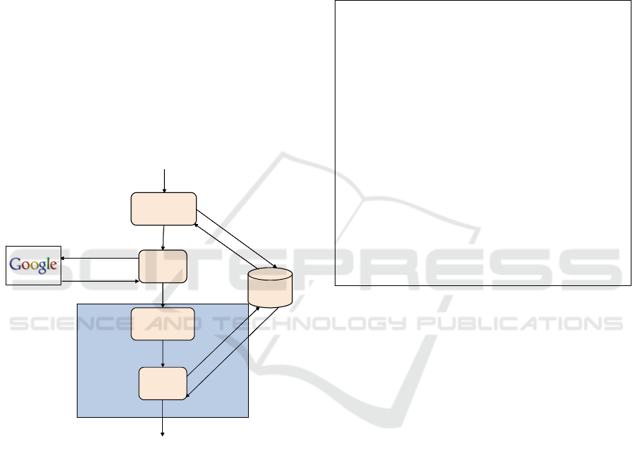
The core server software (Figure 1) is the key
component in the system as it implements the
georeferencing module. It consists of:
1. Relevant municipalities detector
2. Page parser
3. Address and description detector
4. Address validator
Georeferencing module
Geocoded
Database
Results
list
Sorted results list
<keyword,
municipality> query
Result
links
C
o
o
r
d
i
n
a
t
e
s
Mu
n
i
ci
p
al
i
t
i
es
l
i
s
t
A
d
d
r
e
s
s
e
s
C
o
o
r
d
i
n
a
t
e
s
Keyword, Address,
Coordinates
Keyword,
Municipalities
Word list
Relevant
municipalities
detector
Page
Parser
Address and
description
detector
Address
validator
Figure 1: Architecture of the core server software.
The Relevant municipalities detector uses the
Geocoded database to find all the municipalities that
are within a predefined search range (e.g. 10 km
square) centered in the user’s location.
The Page parser uses an external search engine
to perform a <keyword, municipality> query for
every municipality detected at the previous step. It
downloads the web-pages found, strips the html tags,
and extracts the text.
The Address and description detector searches
for address blocks, descriptions and telephone
numbers in the web-pages found by the Page parser.
The Address validator uses the Geocoded database
to convert street addresses from the previous step to
geographical coordinates, then validates and filters
the addresses according to a distance threshold. The
validated addresses are used to georeference the
web-pages.
3.2 Street-address Detection
Current prototype uses a rule-based pattern matching
algorithm, which starts with the detection of street-
names (Figure 2).
StreetNameDetection(words)
{
WHILE i < count(words) DO
{
IF words[i] = street name THEN
{
Search for street number, postal code and other
address elements near words[i].
IF address elements found THEN
{
Create address block
Get coordinates using Geocoded database
IF coordinates found THEN
Add address block to address list
}
}
i = i + 1;
}
}
Figure 2: Pseudocode for address detection.
If a street-name is found, an address-block
candidate is constructed by detecting other typical
address elements, such as street numbers, postal
codes and municipal names. The application looks
for these elements in the vicinity of the found street-
name. Variations about how addresses are
constructed are taken into account. An address-block
candidate is validated using the Geocoded database.
If the detected address has corresponding
coordinates in the database, it is considered as valid;
otherwise it is discarded.
Since a plain address without any additional
information is not a useful search result alone, the
application extracts descriptive information relative
to the address. The current implementation simply
extracts a part of the text preceding the address as
descriptive information. This information is used to
create a search result, which is composed of the
following: descriptive phrase, telephone number (if
detected), address, web link, map link and Euclidian
distance between user and the target location.
WEBIST 2010 - 6th International Conference on Web Information Systems and Technologies
240

3.3 Street-name Detection
Street-name detection is the starting point of the
address detection. One practical issue is the
availability of a gazetteer, as it can be used as a
street-name database. Such databases are commonly
available, but not necessarily free for commercial
purposes. Our application uses a gazetteer of
National Land Survey of Finland, and for Singapore,
we use the street data from OpenStreetMap
7
.
The methods that don't use gazetteer usually
assume that a street-name has a certain structure,
whilst the methods which use a gazetteer rely on fast
word matching. For comparison, we implemented
both approaches: a heuristic method that does not
use a gazetteer, and two text matching methods that
use data extracted from a street-name database.
3.3.1 Heuristic Method
Our heuristic method relies on regular expression
matching. The structure of most of the addresses has
certain particularities. For example, street-names can
start with the same prefix or end with the same
suffix, they can be in the vicinity of standard words
and they are always followed or preceded by a
number. In this case, the address block detection
also starts with the street-name detection and relies
on a set of regular expressions.
According to our experiments, this approach has
very good results for Finnish street-names, because
most of them end in words like “katu” (street), “tie”
(road), “kuja” (lane) or “polku” (path) and has the
advantage that it does not need any database or other
data structures to store the street-names, and it is
reasonably fast.
The accuracy may vary from country to country
and the main disadvantage is that the method has to
be tailored for every country and language because
of the various ways an address block can be
constructed. For example, in Finland it is common
that the address block has <street-name, street
number, postal code, municipality> structure, with
the street type (e.g. road, lane, street, avenue) as a
suffix, whilst in Singapore the <street number, street
name, street type, municipality, postal code> is more
common, but more variations exist. For example, in
Singapore a street-name can be written using
abbreviations such as Av. instead of Avenue, which
is much rarer in Finnish addresses.
7
http://www.openstreetmap.org/
3.3.2 Brute-force Matching using
Street-name Arrays
A brute-force text matching method checks every
word in a web-page against a street-name database.
We use an optimized brute-force solution that
checks the word against all street-names in the
proximity of the location the query is made, for
example the street-names in the municipality where
the user location is.
We use arrays of street-names that are created
beforehand from the gazetteer. Each array is used to
store all the street-names in a municipality and the
search is done using language-specific functions.
Since our search engine is written using PHP scripts,
we use the array_search and in_array functions
optimized to find an object in an array.
3.3.3 Text Matching using Street-name
Prefix Trees
This method uses prefix trees of street-names, which
are created beforehand using the information in our
gazetteer. The gazetteer used in the project is a
geocoded database which contains all the postal
addresses in Finland with their corresponding
coordinates. For Singapore, the prefix trees were
constructed from street names extracted from freely
available map data. Statistical data about both
gazetteers are detailed in Table 1.
Table 1: Gazetteer statistics.
Finland Singapore
Number of municipalities 410 1
Total number of street names 92 572 573
Number of streets per
municipality
474 573
Average street name length 11.6 6.1
Total size (MB) 2 982 0.18
In general, the postal addresses are not unique,
and the same street-name can be found in many
cities. A prefix tree is therefore built for each
municipality and just the prefix trees corresponding
to the search area are loaded during a search.
4 STREET-NAME PREFIX TREE
The prefix tree (or trie) is a fast ordered tree data
structure used for retrieval (Navarro et al., 2002).
The prefix tree stores a collection of strings, indexed
from the beginning of a word (i.e. prefix). The root
node represents an empty string and its children
AD-HOC GEOREFERENCING OF WEB-PAGES USING STREET-NAME PREFIX TREES
241

store the first letter of the string. The same principle
is applied at every level of the tree so that the
internal nodes describe all the sub-strings (prefix) of
the particular string. The recursive version of the
algorithm is presented in Figure 3.
ConstructTrie(streetnames)
{
Create empty node root
FOR i = 1 TO count(streetnames) DO
{
AddString(root, streetnames[i], i);
}
}
AddString(node, string, index)
{
IF (length(string) > 0) THEN
{
IF (string[0] is not the key of a child of node)
THEN
Create new node child with the value
string[0]
ELSE
Set child as the child of node with the key
string[0]
AddString(child, substring(string, 1), index);
}
ELSE //node is a terminal node
{
node.index = index;
}
}
Figure 3: Prefix tree generation pseudocode.
The nodes of the prefix tree can also have values
associated with them, although the only values that
are commonly used are the values of the leaf nodes
and the values of some inner nodes. In our case, we
use the values to mark the end of a street name in the
tree structure. Usually, only the leaf nodes are the
end of a street name, but if a street name is a prefix
of another street name, then an inner node can also
be the end of a street name.
Dictionary search is one of the most common
applications of the prefix tree. It traverses the prefix
tree until it reaches a leaf node, or when a node does
not have any children whose key contains the
desired letter. The recursive version of the prefix
tree search algorithm is presented in Figure 4.
In our implementation, we create prefix trees
from street-names of each municipality. Therefore,
the street-name detection becomes a dictionary
search using prefix tree. Because the Finnish street-
names usually end with a limited number of suffixes,
the names were introduced in the prefix-tree in
reverse order and the search in the prefix-tree is
done starting from the last letter. Figure 5 gives an
example of a prefix tree pre-computed from the
Geocoded database.
FindString(root, string)
{
IF (strlen(string) == 0) THEN
RETURN root.index; //we have reached last
node
ELSE
{
IF (string[0] is not the key of a child of root)
THEN
RETURN -1; //string is not found
ELSE
{
Set child as the child of root with the key
string[0]
RETURN FindString(child,
substring(string,1))
}
}
}
Figure 4: Pseudocode of the Prefix Tree search.
Figure 5: A sample prefix tree built from street-names.
Table 2 summarizes the computed Prefix Trees for
Finland and Singapore. It highlights the fact that the
gazetteer obtained from the OpenStreetMap is not
complete. One of the main advantages of using
prefix trees or other pre-built data structures to
access street-name data from the gazetteer is the fact
that the storage size is reduced (from 3 GB to 74
MB) and the gazetteer is used only for address
validation and geocoding.
WEBIST 2010 - 6th International Conference on Web Information Systems and Technologies
242
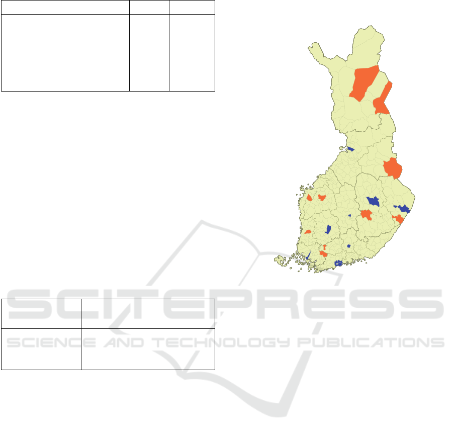
Table 2: Prefix tree statistics.
Finland Singapore
Maximum tree depth 34 14
Average tree depth 12.7 7.4
Average tree width 105 167
Average number of nodes per
tree
2338 2335
Total size (MB) 74.4 0.18
5 EXPERIMENTS
We tested the proposed MOPSI location-based
search engine using 20 different search locations and
10 keywords to construct <keyword, municipality>
queries. We downloaded the content of the first 10
search results for each query of Google search
engine and the downloaded content was used as data
input for the MOPSI prototype.
The search locations were divided into 2 groups:
10 rural 10 urban municipalities (Figure 6), and the
test keywords were divided into 5 commercial and 5
non-commercial ones (Table 3).
Table 3: Keywords used for experiments.
Commercial
hotel, restaurant, pizzeria,
cinema, car repair
Non-commercial
hospital, museum, police
station, swimming hall,
church
The addresses detected by each method were
validated using our geocoded database. The size of
the downloaded data in the rural and urban
municipalities is 13.9 and 11.2 MB, respectively.
Table 4 shows the average time for address
detection and the number of detected addresses for
the considered municipalities. The average time is
calculated per query over all searches. According to
the results, the proposed Prefix Tree method is
considerably faster than the Brute Force method, and
2-3 times faster than the Heuristic approach, which
does not use the gazetteer. Typical search times of
the Prefix Tree are less than 1 second per query.
The detected addresses are validated using our
gazetteer. The accuracy (number of validated
addresses) of the Brute Force and Prefix Tree
methods are higher than that of the Heuristic
method. The biggest difference between urban and
rural municipalities is that the number and the
density of streets are much larger in the urban
municipalities and, therefore, the methods using
gazetteer (Prefix Tree and Brute Force) are slower in
rural municipalities. Nevertheless, the Prefix Tree
method is the fastest even in this case.
Figure 6: Locations used for experiments. The urban
locations (blue): Espoo, Helsinki, Joensuu, Jyväskylä,
Kuopio, Lahti, Oulu, Tampere, Turku, Vantaa; the rural
locations (orange): Forssa, Kitee, Kuhmo, Laihia, Lapua,
Pieksämäki, Salla, Sodankylä, Somero, Ulvila.
The results also show that, for the Heuristic
solution, street density and city size do not affect
much the search times. In case of Prefix Tree
method, the average search time is somewhat bigger
in rural municipality (0.51 vs. 0.87 seconds). The
Brute Force method is affected most by the street
density as the search times in the street array are
bigger than the ones in the prefix tree, resulting in
more than 3 times longer search time in urban areas.
In total, the proposed Prefix Tree method is
twice as fast as and 10% more accurate than the
Heuristic method, on average. It reaches the same
accuracy than the Brute Force search but using only
10% of the processing time.
6 CONCLUSIONS
Our main goal to design a gazetteer-based street
address detector was to increase the accuracy in
comparison to the fast heuristic method that was
used in the earlier implementation (Fränti et al.,
2010). This goal was achieved, as the proposed
AD-HOC GEOREFERENCING OF WEB-PAGES USING STREET-NAME PREFIX TREES
243

prefix tree solution is 57% faster and 10% more
accurate, on average, than the heuristic solution. In
comparison to Brute Force, it is 10 times faster.
The resulting solution improves the speed and
quality of web-page georeferencing and removes
one bottleneck for creating efficient location-based
search engine as the prototype MOPSI search.
Table 4: Average search times for the address detection.
Method
Time (s)
Standard
deviation
Number of
validated
addresses
Rural municipalities
Brute-Force 3.01 2.43 3.7
Heuristic 1.54 1.15 2.5
Prefix Tree 0.51 0.35 3.7
Urban Municipalities
Brute-Force 10.18 7.11 19.8
Heuristic 1.70 1.24 18.6
Prefix Tree 0.87 0.85 19.8
Total
Brute-Force 6.59 6.40 11.8
Heuristic 1.62 1.20 10.5
Prefix Tree 0.69 0.68 11.8
ACKNOWLEDGEMENTS
The research was supported by EU/EAKR and the
work of Ville Hautamäki by the Academy of
Finland, under project 131298.
REFERENCES
Ahlers D. and Boll S. (2008a). Retrieving address-based
locations from the web. Int. Workshop on Geographic
Information Retrieval, 27-34, Napa Valey, CA.
Ahlers D. and Boll S. (2008b). Urban Web Crawling.
ACM Int.workshop on Location and the web. Vol. 300,
25–32. Beijing, China.
Amitay E., Har'El N., Sivan R. and Soffer A. (2004).
Web-a-where: geotagging web content. ACM SIGIR
Conf. on Research and Development in Information
Retrieval, Sheffield, UK, 273–280.
Borges K., Laender A., Medeiros C. and Davis Jr. C.
(2007). Discovering geographic locations in web
pages using urban addresses. ACM Workshop on
Geographical Information Retrieval. Lisbon, Portugal,
31-36.
Buyukkokten O., Cho J., Garcia-Molina H., Gravano L.
and Shivakumar N. (1999). Exploiting geographical
location information of web pages. WebDB (Informal
Proceedings), – dbpubs.stanford.edu
Cai W., Wang S. and Jiang Q. (2005). Address Extraction:
Extraction of Location-Based Information from the
Web. Web Technologies Research and Development -
APWeb 2005, Volume 3399/2005, 925-937
Can L., Qian Z., Xiaofeng M. and Wenyin L. (2005).
Postal address detection from web documents. Web
Information Retrieval and Integration. Int. Workshop
on Challenges in Web Information Retrieval and
Integration, 40 - 45
Fränti P., Kuittinen J., Tabarcea A. and Sakala L. (2010).
MOPSI Location-based Search Engine: Concept,
Architecture and Prototype. ACM Symposium on
Applied Computing, Sierre, Switzerland.
Gravano L., V Hatzivassiloglou V. and Lichtenstein R.
(2003). Categorizing web queries according to
geographical locality. Int. Conf. on Information and
Knowledge Management, New Orleans, LA, 325–333.
Hariharan G., Fränti P. and Mehta S. (2002). Data mining
for personal navigation. SPIE Conf. on Data Mining
and Knowledge Discovery, vol. 4730, 355-365.
Hill L., Frew J. and Zheng Q. (1999). Geographic names:
The implementation of a gazetteer in a georeferenced
digital library. D-Lib Mag., January 1999, 5 (1)
Jones C.B., Abdelmoty A.I. , Finch D., Fu G. and Vaid S.
(2004). The SPIRIT spatial search engine:
Architecture, ontologies and spatial indexing. LNCS
Lecture Notes in Computer Science, Springer.
Kuittinen J. (2006). Using location information in search
engines. MSc thesis, Univ. of Joensuu (in Finnish)
Lee H.C., Liu H. and Miller R.J. (2007). Geographically-
Sensitive Link Analysis. IEEE/WIC/ACM Int. Conf. on
Web Intelligence, Silicon Valley, CA, 628–634.
McCurley, K.S. (2001). Geospatial mapping and
navigation of the web. Int. Conf. on WWW, 221-229.
Mikheev A., Moens M. and Grover C. (1999). Named
entity recognition without gazetteers. Conf. on
European Chapter of the Association for
Computational Linguistics, Bergen, Norway, 1–8.
Morimoto Y., Aono M., Houle M.E. and McCurley K.S.
(2003). Extracting spatial knowledge from the web.
Symposium on Applications and the Internet, 326–333.
Navarro G. and Raffinot M. (2002). Flexible Pattern
Matching in Strings. Cambridge University Press.
Silva M.J., Martins B., Chaves M., Afonso A.P. and
Cardoso N. (2006). Adding geographic scopes to web
resources. Computers, Environment and Urban
Systems, 30 (4), GIR, 378–399.
Souza L.A., Davis C.A. Jr.,Borges, K.A.V., Delboni T.M.
and Laender A.H.F. (2005). The role of gazetteers in
geographic knowledge discovery on the Web. 3rd
Latin American Web Congress, 9.
Viola P. and Narasimhan M. (2005). Learning to extract
information from semi-structured text using a
discriminative context free grammar. ACM SIGIR
Conf. on Research and Development in Information
Retrieval, Salvador, Brazil, 330–337.
Wang C., Xie X., Wang L., Lu Y. and Ma W.Y. (2005).
Detecting geographic locations from web resources.
Workshop on Geographic Information Retrieval,
Bremen, Germany, 17 – 24.
WEBIST 2010 - 6th International Conference on Web Information Systems and Technologies
244
