
COMBINING ABSOLUTE POSITIONING AND VISION FOR WIDE
AREA AUGMENTED REALITY
Tom Banwell and Andrew Calway
Department of Computer Science, University of Bristol, Bristol, U.K.
Keywords:
Visual SLAM, Localisation, Mapping, Absolute positioning, Augmented reality, Sensor fusion.
Abstract:
One of the major limitations of vision based mapping and localisation is its inability to scale and operate over
wide areas. This restricts its use in applications such as Augmented Reality. In this paper we demonstrate
that the integration of a second absolute positioning sensor addresses this problem, allowing independent local
maps to be combined within a global coordinate frame. This is achieved by aligning trajectories from the two
sensors which enables estimation of the relative position, orientation and scale of each local map. The second
sensor also provides the additional benefit of reducing the search space required for efficient relocalisation.
Results illustrate the method working for an indoor environment using an ultrasound position sensor, building
and combining a large number of local maps and successfully relocalising as users move arbitrarily within the
map. To show the generality of the proposed method we also demonstrate the system building and aligning
local maps in an outdoor environment using GPS as the position sensor.
1 INTRODUCTION
A fundamental requirement for Augmented Reality
(AR) applications is to be able to localise the pose of
a mobile device with respect to the physical environ-
ment. In the past, work in this area has focused pri-
marily on localisation based on known structure in the
form of calibrated targets (Piekarski et al., 2004) or
models (Park et al., 2008; Pupilli and Calway, 2006).
However, more recent work has attempted to over-
come the limitations of this by employing techniques
able to operate in previously unseen environments. Of
particular interest has been the significant advances
made in vision based simultaneous localisation and
mapping (SLAM) systems which have their roots in
the Robotics literature, see for example the monocular
systems described in (Davison et al., 2007; Chekhlov
et al., 2006; Klein and Murray, 2007). These systems
have now reached a level of robustness where they
can be reliably used in a variety of AR applications
(Chekhlov et al., 2007; Castle et al., 2008). Although
the robustness and reliability of these visual SLAM
systems is impressive, the challenge of building very
large maps over wide areas still remains. One limit-
ing factor is computational effort, which for most al-
gorithms increases quadratically with the number of
features in the map. This can be addressed by adopt-
ing sub-mapping techniques to build consistent maps
over relative wide areas (Clemente et al., 2007;
Pinies and Tardos, 2008). Pinies and Tardos build
sub-maps of limited size before initialising a new map
referenced to the current pose, allowing the sharing of
common information. Remapping common features
in two sub-maps enables loop closure and the sub-
maps to be joined into a single global map (Pinies
and Tardos, 2008). Although these systems enable
a wider area to be mapped, they assume continuous
texture between the sub-maps and cannot handle sit-
uations where there is no texture or when the camera
has been kidnapped.
To overcome these limitations Castle et al (Castle
et al., 2008) developed a system that assumes there
is not always continuous texture between sub-maps.
Their system enables a user to build sub-maps in ar-
eas of interest and relocalise in those maps once they
return to them. This allows users to build sub-maps
of spatially separated areas. However, the relative lo-
cation and orientation of the sub-maps are not known
and relocalisation may become an issue once there are
a large number of maps.
A kidnapped camera can provide no informa-
tion about its current position relative to a previous
map until it reobserves features from that map. One
method to recover such information would be to seek
support from an additional sensor.
Pinies et al (Pinies et al., 2007) combine their mo-
353
Banwell T. and Calway A. (2010).
COMBINING ABSOLUTE POSITIONING AND VISION FOR WIDE AREA AUGMENTED REALITY.
In Proceedings of the International Conference on Computer Graphics Theory and Applications, pages 353-357
DOI: 10.5220/0002830803530357
Copyright
c
SciTePress

Figure 1: User with mobile device and laptop desk.
nocular-camera system with an Inertial Measuring
Unit, this improves their estimated trajectory and
map. Newman et al (Newman et al., 2001) devel-
oped a building-wide AR system by combining ultra-
sound position estimates and rotation estimates from
an inertial tracker. This allows the wearer of a head
mounted display to be positioned, but does not pro-
vide detailed information about the environment they
are in. The main focus of these systems has been im-
proving the overall system robustness or improving
the accuracy of the estimate.
In this work we overcome these limitations by us-
ing a second sensor, an absolute positioning system
(APS). During areas of texture we simultaneously es-
timate our global trajectory using the APS and our
local trajectories using a monocular-camera system.
Using a least-squares approach we estimate the trans-
formation between the global and local trajectories
and build a single scalable consistent global map.
During periods of loss of visual information we use
the APS to estimate 3-D position within the global
map. This allows the system to efficiently relocalise,
when returning to a previously built local map, even
when there are a very large number of maps.
Results show that by using a second sensor we can
overcome the limitations of scalability and the need
for continuous texture, and buildmany local maps that
are known relative to one another. This provides us
with a novel AR capability, to be able to track in a
local map and see AR in other local maps that are not
joined to the current local map by continuous texture.
The remainder of the paper is organised as fol-
lows. The next section describes the general frame-
work for combining a mapping system with an APS.
The third section describes the implementation we
have developed based on this framework. Conclu-
sions are drawn in the final section.
2 POSITIONING AND VISION
This section describes the core method underlying our
work described in a general framework. One of the
advantages of our method is that it is directly appli-
cable to any camera mapping system, for example;
probabilistic and Structure from Motion approaches
and any absolute positioning system, for example; Ul-
trasound, Ultra-Wideband and GPS.
Another advantage of this work is that we can
create a very large number of local maps at an arbi-
trary position, orientation and scale and combine all
of these maps into a single coordinate frame to pro-
vide a single scalable global map. Crucially, the es-
timated map and trajectory from the local mapping
system are locally correct, but a transformation out,
when compared to the estimate in the global coordi-
nate frame. By simultaneously estimating this local
trajectory and the global trajectory we are able to es-
timate this alignment transformation and combine the
local maps into the global coordinate frame.
2.1 Estimating Transformations
We begin by estimating the motion of a mobile device
using two sensors; a monocular-camera and an abso-
lute positioning system. The two sensors are rigidly
attached at a known offset. Each sensor estimates the
mobile’s trajectory in their own coordinate frame; our
goal is to recover the transformation between the two
coordinate frames.
To estimate the transformation we need to esti-
mate two trajectories, propagated to a common time.
After each measurement update a new position is es-
timated and this is stored in the trajectory set. This
provides us with two sets of data, or trajectories, X
for the vision system and Y for the absolute position-
ing system.
Now we have the two trajectories we estimate
the transformation between them. We find it best
to estimate the transformation parameters over the
full trajectories once the local map has been ‘fin-
ished’. To estimate the desired transformation we
use a least-squares approach introduced by Umeyama
(Umeyama, 1991). This method is based on Singu-
lar Value Decomposition, which is known for its nu-
merical stability. We now give a brief overiew of the
method. First we find the means and variances of the
two trajectories and then the covariance Σ
xy
, between
the two. We then determine the singular value de-
composition of Σ
xy
which gives UDV
T
. From these
matrices we follow the steps described in Umeyama
(Umeyama, 1991) to estimate the rotation R, transla-
tion t, and scale s, of the transformation. These are
the parameters of the transformation required to con-
vert the local map into the global map.
2.2 Building the Global Map
Once the transformation parameters s
j
, R
j
and t
j
have
been estimated for local map j, they can be used to
GRAPP 2010 - International Conference on Computer Graphics Theory and Applications
354

(a) Relocalised Camera (b) Mapping with GPS
Figure 2: (a) Relocalised within a local map: the mean-
spheres in neighbouring maps can be seen. (b) Local maps
aligned with a truly global coordinate frame.
transform the local map into the global coordinate
frame. The trajectory X
l j
of local map j, is trans-
formed into the global coordinate system X
gj
as fol-
lows:
X
gj
= s
j
R
j
X
l j
+ t
j
(1)
Each local-feature f
li
, in local map j, can be trans-
formed to the global coordinate frame f
gi
as follows:
f
gi
= s
j
R
j
f
li
+ t
j
(2)
3 EXPERIMENTAL RESULTS
To demonstrate our method we conducted experi-
ments both indoors, using an ultrasound system, and
outdoors using GPS.
3.1 Indoor Office Environment
The hardware was setup as shown in Figure 1. The
user has a handheld mobile device that consists of
two sensors that are rigidly attached at a known off-
set. The two sensors are; a calibrated handheld cam-
era with 320x240 pixels and wide-angled lens, and
an ultrasound receiver. To enable mobility a laptop
desk is used to carry the laptop. An ultrasound po-
sitioning system is used to provide estimates of 3-D
position (Randell and Muller, 2001). To provide the
local maps and trajectories we use the visual-SLAM
system developed by Chekhlov et al (Chekhlov et al.,
2006).
3.1.1 Building and Correcting Local Maps
Testing was performed in an indoor environment. A
sequence of steps can be seen in Figure 3 (the full ex-
periment can be seen in the attached video). The ul-
trasound system estimates the 3-D position of the mo-
bile device in the global coordinate frame. Although
in practice one would want to start a new map after a
loss of visual track, for ease of testing we allow the
user to control the building of local maps. The user
provides input to start building a local map. Once
the user has decided they have finished building the
local map they again provide input and the system
stops building the current local map. At this point the
system estimates the transformation to align the local
trajectory with the global trajectory and applies that
transformation to the local estimate.
3.1.2 Viewing into and Across Local-maps
One of the major advantages our method offers for
AR applications is the ability to see across disjoint
maps. To demonstrate this we placed rotating spheres
at the mean of aligned maps, as can be seen in Figure
3. After aligning six local maps the user entered the
relocalisation phase. The mobile returned to and relo-
calised in the second map (green sphere). As this lo-
cal map had been globally aligned the camera’s global
position could be estimated. All global graphics can
be seen in the camera view allowing it to ‘look-across’
maps and see the contents of those maps. This is
shown in Figure 2a. This novel contribution is not
achievable with other current single-camera systems.
3.1.3 Efficient Relocalisation
To demonstrate the second contribution of our work
we improve the relocalisation method developed by
Chekhlov et al (Chekhlov et al., 2008). Between
building local maps, if the user returns to a previously
mapped area, we seek to relocalise the camera. Once
there are a very large number of maps, it is unrealis-
tic to attempt to relocalise in all maps. Our contribu-
tion comes from the fact that our method provides us
with an estimate of the global position of the mobile
and all local maps. We use this information to decide
which local map(s) we should attempt to relocalise
in. Once the current local map has been ‘finished’
the system enters a relocalisation phase. A map is se-
lected as a potential for relocalisation if it falls within
a sphere centered about the mobile’s position. The
sphere defines a region where there is a significantly
high chance of being able to detect features from the
map, it’s radius is estimated based on the distance be-
tween the mobile’s current position and the mean of
the local map.
3.2 Combining GPS and Vision
To demonstrate the generality of our method we have
applied it using an alternative sensor, GPS. Using
GPS we have the potential to scale across very wide
COMBINING ABSOLUTE POSITIONING AND VISION FOR WIDE AREA AUGMENTED REALITY
355
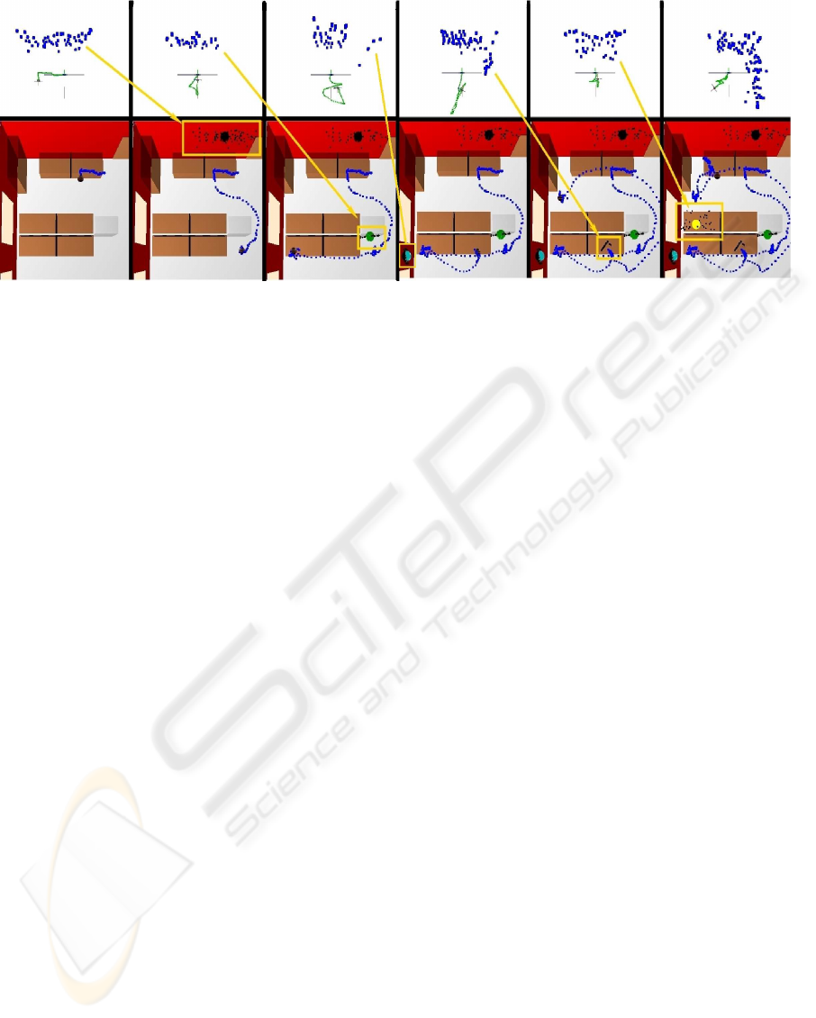
Figure 3: Screenshots from a map building sequence. The top row shows the building of local maps, with the locally estimated
trajectory (green) and features (blue). The bottom row shows the same trajectory estimated in the global coordinate frame
(blue dotted-line) and the correctly transformed local maps (black). The arrows (yellow) represent the correct transformation
of the local maps. The spheres (black, green, cyan and yellow) represent the means of the local maps.
areas and the entire global. This enables users to share
maps and combine them with applications such as
Google Earth. Using the same mapping system as de-
scribed in section 3.1 and the method of section 2 we
tested the system outside by walking around a build-
ing. Each wall of the building was locally mapped
using the vision system, once finished the local map
was aligned with the global coordinate frame to up-
date the global map. This can be seen in Figure 2b.
4 CONCLUSIONS
This work developed a new scalable mapping and lo-
calisation technique. It combines trajectories from
an absolute positioning system and a local mapping
system to produce a single map. The key contribu-
tions are the ability to map in areas where there is no
continuous texture and the correct alignment of local
maps into a single global coordinate system. The po-
sition and orientation of the local maps are known rel-
ative to each other. This provides the ability to view
across disjoint maps and improves the efficiency of re-
localisation. We demonstrated our method by build-
ing and transforming local maps to a global coordi-
nate frame using different sensors both indoors and
outdoors. Future work will focus on auto-calibrating
the ultrasound system to reduce the installation cost.
ACKNOWLEDGEMENTS
We are grateful to Walterio Mayol-Cuevas, Andrew
Gee and Denis Chekhlov for discussions and to Cliff
Randell and Henk Muller for help with the ultrasound
positioning system.
REFERENCES
Castle, R. O., Klein, G., and Murray, D. W. (2008). Video-
rate localization in multiple maps for wearable aug-
mented reality. In Proc 12th IEEE Int Symp on Wear-
able Computers 2008, pages 15–22.
Chekhlov, D., Gee, A., Calway, A., and Mayol-Cuevas,
W. (2007). Ninja on a plane: Automatic discovery
of physical planes for augmented reality using visual
slam. In International Symposium on Mixed and Aug-
mented Reality (ISMAR).
Chekhlov, D., Mayol-Cuevas, W., and Calway, A. (2008).
Appearance based indexing for relocalisation in real-
time visual slam. In 19th Bristish Machine Vision
Conference, pages 363–372. BMVA.
Chekhlov, D., Pupilli, M., Mayol-Cuevas, W., and Calway,
A. (2006). Real-time and robust monocular slam using
predictive multi-resolution descriptors. In 2nd Inter-
national Symposium on Visual Computing.
Clemente, L., Davison, A., Reid, I., Neira, J., and Tardos, J.
(2007). Mapping large loops with a single hand-held
camera. In Robotics: Science and Systems.
Davison, A., Reid, I., Molton, N., and Stasse, O.
(2007). MonoSLAM: Real-Time Single Camera
SLAM. IEEE Transactions on Pattern Analysis and
Machine Intelligence, 29(6):1052–1067.
Klein, G. and Murray, D. (2007). Parallel tracking and
mapping for small AR workspaces. In Proc. Sixth
IEEE and ACM International Symposium on Mixed
and Augmented Reality (ISMAR’07), Nara, Japan.
Newman, J., Ingram, D., and Hopper, A. (2001). Aug-
mented reality in a wide area sentient environment.
GRAPP 2010 - International Conference on Computer Graphics Theory and Applications
356

In Augmented Reality, 2001. Proceedings. IEEE and
ACM International Symposium on, pages 77–86.
Park, Y., Lepetit, V., and Woo, W. (2008). Multiple 3d ob-
ject tracking for augmented reality. In Proc. Seventh
IEEE and ACM International Symposium on Mixed
and Augmented Reality, pages 117–120.
Piekarski, W., Avery, B., Thomas, B., and Malbezin, P.
(2004). Integrated head and hand tracking for indoor
and outdoor augmented reality. In VR ’04: Proceed-
ings of the IEEE Virtual Reality 2004, pages 11–276,
Chicago, IL.
Pinies, P., Lupton, T., Sukkarieh, S., and Tardos, J. D.
(2007). Inertial aiding of inverse depth slam using a
monocular camera. In IEEE International Conference
on Robotics and Automation, Roma, Italy.
Pinies, P. and Tardos, J. (2008). Large-scale slam building
conditionally independent local maps: Application to
monocular vision. IEEE Transactions on Robotics,
24(5):1094–1106.
Pupilli, M. and Calway, A. (2006). Real-time camera track-
ing using known 3d models and a particle filter. In
International Conference on Pattern Recognition.
Randell, C. and Muller, H. (2001). Low cost indoor posi-
tioning system. In Ubicomp 2001: Ubiquitous Com-
puting, pages 42–68.
Umeyama, S. (1991). Least-Squares Estimation of Trans-
formation Parameters Between Two Point Patterns. In
IEEE Transactions on Pattern Analysis and Machine
Intelligence, volume 13, pages 376–380.
COMBINING ABSOLUTE POSITIONING AND VISION FOR WIDE AREA AUGMENTED REALITY
357
