
GEOPROFILE
UML Profile for Conceptual Modeling of Geographic Databases
Gustavo Breder Sampaio, Filipe Ribeiro Nalon and Jugurta Lisboa-Filho
Departamento de Informática, Universidade Federal de Viçosa (UFV), 36570-000 Viçosa, MG, Brazil
Keywords: UML profile, Conceptual model, GIS, Geographic database.
Abstract: After many years of research in the field of conceptual modeling of geographic databases, experts have
produced different alternatives of conceptual models. However, still today, there is no consensus on which
is the most suitable one for modeling applications of geographic data, which brings up a number of
problems for field advancement. A UML Profile allows a structured and precise UML extension, being an
excellent solution to standardize domain-specific modeling, as it uses the entire UML infrastructure. This
article presents the metamodel of a UML profile developed specifically for conceptual modeling of
geographic databases called GeoProfile. This is not a definite proposal; we view this work as the first step
towards the unification of the various existing models, aiming primarily at semantic interoperability.
1 INTRODUCTION
For the past 20 years, a number of research groups
have been studying the requirements for conceptual
modeling used in GIS applications (Bédard et al.,
2004). A large number of conceptual models
specific to this area were proposed. OMT-G (Borges
et al., 2001), MADS (Parent et al., 2008), GeoOOA
(Kösters et al., 1997), UML-GeoFrame (Lisboa
Filho and Iochpe, 2008) and the Perceptory's model
(Bédard, 1999) are important among these models.
Despite the maturity of this research field, to
date, there is no consensus among designers and
users as to which model best meets the requirements
for modeling a geographic database (GeoDB). The
lack of a standard model brings up serious problems
in the development of the field, as for instance,
communication difficulties among different projects.
For example, considering CASE tools that support
conceptual models specific to GeoDB, data
conceptual schemas cannot be migrated between
different tools, as it happens with conventional
database designs.
These problems would not exist if there were a
standard for modeling such applications that
incorporated the main features of the existing
models. The creation of a UML profile is one option
to standardize this type of models. UML profile is a
feature that allows for a structured and precise
extension of the UML elements so that it can fit into
a specific domain (Fuentes and Vallecillo, 2004).
This paper aimed to initiate the specification of a
UML Profile for the conceptual modeling of GeoDB
taking into account the requirements imposed on this
application domain. Some models in the literature
provided the basis for this task.
The remaining of the paper is structured as
follows. Section 2 describes the GeoDB conceptual
modelling and the main current models, while
Section 3 details the proposal to the GeoProfile.
Section 4 presents the conclusions and future work.
2 CONCEPTUAL MODELING OF
GEOGRAPHIC DATABASE
The profile proposed in this paper is based on
contributions from a number of models existing in
the literature, as well as the concepts defined in
Goodchild et al. (2007). The models that have
contributed most significantly to the GeoProfile
development are cited below, but certainly other
predecessor models also had their contribution.
The OMT-G (Object Modeling Technique for
Geographic Applications) model (Borges et al.,
2001) has a rich collection of conceptual
constructors, the strong point of which is modeling
spatial relationships, including spatial aggregation.
The GeoOOA model (Kösters et al., 1997) supports
the abstraction of spatial classes, whole-part
topological structures, network structures and
409
Breder Sampaio G., Ribeiro Nalon F. and Lisboa-Filho J. (2010).
GEOPROFILE - UML Profile for Conceptual Modeling of Geographic Databases.
In Proceedings of the 12th International Conference on Enterprise Information Systems - Information Systems Analysis and Specification, pages
409-412
DOI: 10.5220/0002854004090412
Copyright
c
SciTePress

temporal classes. MADS (Modeling of Application
Data with Spatio-temporal Features) (Parent et al.,
2008) approaches objects and relationships in its
diagram, with structures very similar to the Entity-
Relationship model. The Perceptory’s model
(Bédard, 1999) was the pioneer in the use of
pictograms. These pictograms are grouped into the
languages Spatial PVL and Temporal PVL (Plug-in
for Visual Languages), which allow the addition of
spatial-temporal characteristics not only to UML,
but also to other visual modeling languages. The
UML-GeoFrame model is based on a structured
hierarchy of classes that make up the GeoFrame,
providing the basic elements present in any
geographic database (Lisboa Filho and Iochpe,
1999).
Finally, Clementini et al. (1993) formally
describe a small set of relationships capable of
reproducing all the possible topological relationships
that can occur between spatial elements with the
representation of point, line or area. This work has
considerable importance in the scope of the
GeoProfile design. Defining a minimum set of
relationships, one eliminates the possible use of two
relationships with different names, but having the
same meaning. This set includes the following
relationships: touch, in, cross, overlap and disjoint.
3 GEOPROFILE
GeoProfile is a UML profile built for the conceptual
modeling of geographic databases. According to the
proposed methods to guide the construction of a
UML Profile (Fuentes e Valecillo, 2004) e (Selic,
2007), two artefacts are generated during profile
development: the domain metamodel and the profile
itself. While the first is useful to understand the
addressed problem, the second presents the
extensions received by the UML metaclasses.
Section 3.1 defines a metamodel for the
geographical domain and section 3.2 proposes a set
of stereotypes for the proposed profile.
3.1 Defining a Metamodel for
Geographical Domain
At the beginning of the metamodel specification,
elements are identified in a conceptual schema,
observing the requirements of this type of
conceptual modeling.
The way each considered conceptual model in
this proposal (GeoOOA, MADS, UML-GeoFrame,
OMT-G and Perceptory’s model) meets the found
requirements was examined. The inclusion of the
main mechanisms present in each of these models
into the GeoProfile allows it to meet most
requirements of a geographic database (GeoDB).
Among the discussed conceptual models, the
UML-GeoFrame shows the closest organization to a
metamodel. GeoFrame is defined in a class
hierarchy representing the elements present in a
GeoDB. Thus, the metamodel development started
from a GeoFrame adaptation (Figure 1).
A GeoDB comprises a number of themes, which
is characterized by the metaclass Theme. A theme
can be formed by the aggregation of other themes or
objects with or without spatial representation,
characterized by the classes GeoPhenomenon and
ConventionalObj respectively.
When one chooses to associate a spatial
representation with objects of a class, it is possible
that the phenomenon is perceived in the geographic
field view (GeoField) or object view (GeoObject).
Depending on the technique used in geographic
information acquisition in the field, its representa-
tion be selected from six options as described in
Goodchild et al. (2007): AdjPolygons, Isolines, TIN,
GridOfPoints, GridOfCells or IrregularPoints.
Representation of geographic objects can be of the
types point, line, polygon or complex (the object
geometry consists of other geometries).
With basis on GeoOOA and OMT-G models,
which provide more detailed solutions for network
representation, Stempliuc et al. (2009) proposed an
extension of GeoFrame to address the requirement.
This extension was incorporated into the metamodel.
The classes in charge of storing alphanumeric
data and information on which elements participate
in the network are represented by the metaclass
Network. Since this metaclass does not have spatial
information, it was defined as a ConventionalObj
specialization. The networks are formed by network
objects (NetObject), which can be nodes (Node),
unidirectional arcs (Unidirectional) or bidirectional
arcs (Bidirectional).
For temporal aspects, the solution proposed by
GeoProfile is to indicate only whether a class is
considered temporary or not, as in the GeoOOA
model. In this way, the metaclass TemporalObject
was added to the metamodel. This metaclass has two
attributes that characterize temporal information.
One of these attributes indicates the temporal type
(validity time, transaction time or bitemporal time),
whereas the other defines the used temporal
primitive type (instant or interval). There are two
enumerations (TemporalType and TemporalPrimiti-
ve) for the possible values these attributes can
assume.
ICEIS 2010 - 12th International Conference on Enterprise Information Systems
410
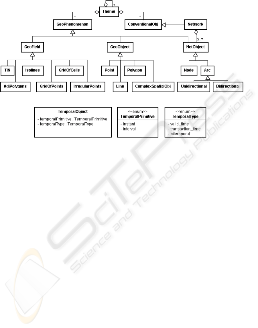
Figure 1: Metamodel for the geographical domain.
3.2 GeoProfile Stereotypes
After creating the domain metamodel, the next step
is to extend the UML metaclasses to create the
profile itself. Figure 2 illustrates the stereotypes of
GeoProfile.
It is worth noting that not all metaclasses of the
domain metamodel have a corresponding stereotype,
as it happens with Theme and ConventionalObj.
Themes can be represented by packages. Classes of
conventional objects are, however, modeled by
UML classes without addition of stereotypes.
Therefore, the UML constructors themselves can
reproduce these two concepts.
Geographic phenomena, extending the metaclass
Class, are defined in a similar hierarchy to that
found in the domain metamodel. The stereotype
Network directly extends the metaclass Class, since
there is no stereotype defined for representation of
conventional objects.
To deal with temporal aspects, the stereotype
TemporalObject was added to GeoProfile, as well as
two enumerations (TemporalPrimitive and Tempo-
ralType). In addition, designers are allowed to
indicate that an association between two objects is
only valid for one period and this history should be
kept in the database.
This is done by simply assigning the stereotype
Temporal, which extends the metaclass Association
to an association of the schema.
Finally, stereotypes were created to represent the
topological relationships that were not considered
during drawing up of metamodel. We chose to use
the set of five relationships proposed by Clementini
et al. (1993), as they are capable of representing any
topological relationship between objects of type
point, line or polygon. Thus, the stereotypes Touch,
In, Cross, Overlap and Disjoint, all extending the
metaclass Association, were added.
4 CONCLUSIONS
This article showed a standard conceptual model for
geographic database modeling to be feasible. The
existence of several alternative conceptual models of
geographical databases prevents users and designers
to migrate their projects from a CASE tool to
another. Other major problem brought up by the lack
of standardization is the difficulty in training
designers, since although the models have been
produced for the same purpose; each one has its
differences and particularities. Users who are
familiar with a model (and its respective CASE tool)
show strong resistance to accept a new one.
The use of a UML profile will solve these
problems. Besides the wide UML acceptance by
software developers, the availability of CASE tools
with support for profiles rule out the need for
implementing specific tools for a particular model.
GEOPROFILE - UML Profile for Conceptual Modeling of Geographic Databases
411
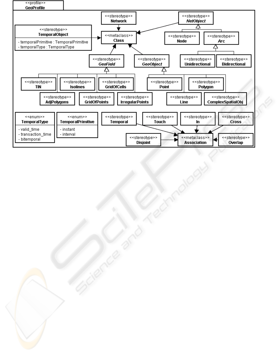
Figure 2: GeoProfile Stereotypes.
A subject for future work is the logical-
conceptual transformation of schemas produced with
GeoProfile. The existence of logical standards, as
defined by OGC and the series ISO 19100, will have
a strong link with the level of conceptual modeling.
Finally, the great challenge is to make authors of the
existing conceptual models contribute to improve
the GeoProfile. Moreover, to know the opinion of
the users is important, because in many cases the
database of a GIS application is designed by then.
Thus, it is also important to measure the GeoProfile
use’s facility and its learning curve.
ACKNOWLEDGEMENTS
This project was partially funded by CAPES,
FAPEMIG and CNPq / MCT / CT-Info.
REFERENCES
Bédard, Y.; Larrivée, S.; Proulx, M. and Nadeau, M. 2004.
Modeling geospatial databases with plug-ins for visual
languages: a pragmatic approach and the impacts of 16
years of research and experimentations on Perceptory.
In CoMoGIS. LNCS.3289, Springer, pp. 1148-1158.
Bédard, Y. 1999. Visual modeling of spatial databases:
towards spatial PVL and UML. Geomatica, v.53, n.2,
pp. 169-186.
Borges, K. A. V.; Davis Jr., C. A. and Laender, A. H. F.
2001. OMT-G: An object-oriented data model for
geographic applications. GeoInformatica, v. 5, n. 3.
Brodeur, J., Badard, B. 2008. Modeling with ISO 191xx
standard. In Encyclopedia of GIS, Eds. Shekhar, S.
and Xiong, H., Springer-Verlag, pp. 705-716.
Clementini, E.; Di Felice, P. and Oosterom, P. 1993. A
small set of formal topological relationships suitable
for end-user interaction. In: Int. Symp. on Advances in
Spatial Databases, Springer-Verlag. London.
Fuentes, L.; Vallecillo, A. 2004. An introduction to UML
profiles. UPGRADE, The European Journal for the
Informatics Professional, v.5, n.2, pp. 6-13.
Goodchild, M. F. ;Yuan, M. and Cova, T. J. 2007.
Towards a general theory of geographic representation
in GIS. Int. Journal of GIS, pp. 239-260.
Kösters, G. et al. 1997. GIS-Application Development
with GeoOOA. International Journal of Geographical
Information Science, v. 11, n. 4, pp. 307-335.
Lisboa Filho, J. and Iochpe, C. 2008. Modeling with a
UML Profile. In Encyclopedia of GIS, Eds. Shekhar,
S. and Xiong, H., Springer-Verlag, pp. 691-700.
OMG - Object Management Group. 2007. Unified
Modeling Language: Infrastructure. V. 2.1.2.
Parent, C.; Spaccapietra, S. and Zimányi, E. 2008.
Modeling and multiple perceptions. In Encyclopedia
of GIS, Eds. Shekhar, S. and Xiong, H., Springer-
Verlag, pp. 682-690.
Selic, B. 2007. A systematic approach to domain-specific
language design using UML. In 10
th
IEEE Int. Symp.
on Object and Component-Oriented Real-Time
Distributed Computing (ISORC’07), pp. 2-9.
Stempliuc, S. M.; Lisboa Filho, J.; Andrade, M. V. A. and
Borges, K. V. A. 2009. Extending the UML-
GeoFrame data model for conceptual modeling of
network applications. In Int. Conf. on Enterprise
Information Systems (ICEIS), Milão.
ICEIS 2010 - 12th International Conference on Enterprise Information Systems
412
