
The Technology of Dynamic Extension of Attribute Set
for the Search of Satellite Images in a Database
Yuri Maglinets, Eugene Maltsev, Ruslan Brejnev
Alexey Sosnin and Victor Kurnosov
Institute of Space and Information Technology, Siberian Federal University
Kirenskogo ul. 26, Krasnoyarsk, 660074, Russian Federation
Abstract. The structures of metafiles for describing satellite images of the
Earth we analyze in this article. We describe the architecture of interaction
among the satellite images database components at the automated registration
of new-type sensors. We offer the technology of dynamic extension of the
attribute set for the search of satellite images in a database.
1 Introduction
Last decade has been marked by a rapid development of satellite technologies for
Earth remote sensing. Cumulative orbital group of space vehicles (SV) launched in
the world is increasing continuously at the expense of new launches; new sensor
types are being developed; resolution and accuracy of the data received are improv-
ing. Raster images received from SV are accompanied by attributive information
which is stored in metadata files. (Image Support Data, ISD).
Notwithstanding certain progress achieved in the world in the field of standardiza-
tion of geospatial information communication protocols owing to some organizations
and consortia such as ESA, CEOS, OGC etc. [1,2], ISD content standardization level
leaves much to be desired. Each of the SV producers develops independently formats
of the corresponding ISD that leads to wide variability both in data representation
formats and in the structure of representation of the information in these files. Syntax
Parameter Value Language (PVL) and syntax Extensible Markup Language (XML)
are the most widespread.
A regional database of the Earth surface images (RDESI) received with the use of
artificial Earth satellites has been created at the Institute of space and Information
Technology of Siberian Federal University [3]. The data arrives from various sources:
own receiving centers, open databases of partner organizations. The aim of creation
of the regional database is to organize access to the geospatial information for a wide
range of users such as teachers, scientific employees, post-graduate students and
students of the university, representatives of other research institutions, and also pub-
lic authorities, the commercial organizations and others. It allows to set and solve
various tasks of remote sensing of the Earth surface that is especially topical for
Maglinets Y., Maltsev E., Brejnev R., Sosnin A. and Kurnosov V. (2010).
The Technology of Dynamic Extension of Attribute Set for the Search of Satellite Images in a Database.
In Proceedings of the Third International Workshop on Image Mining Theory and Applications, pages 29-34
DOI: 10.5220/0002961600290034
Copyright
c
SciTePress

sparsely populated Central Siberia where remote sensing becomes the only reliable
source of information for decision-making, taking into account underdeveloped
transport infrastructure in this region.
It is known that the number of attributes of a separate ISD file can reach several
hundred. ISD files from different satellites generally contain different groups of
attributes. A structure of information queries of the user of the system differs consi-
derably as well. It is due to the differences in purposes of using the system (scientific,
educational, industrial), solved problems, operational experience and other factors,
characteristic for this or that user of the system.
Thus it is topical to discuss questions concerning adaptation of satellite images da-
tabase to the constantly changing requirements of users and appearance of new data
representations caused by new-type sensors registered in the system.
In this work we offer a technology of automated RDESI adaptation to the con-
stantly changing external conditions.
2 A Review of the ISIT SFU (Institute of Space and Information
Technology, Siberian Federal University) Satellite Images
Database
At present we have data collected from optical satellites: Landsat 4-5 sensor TM,
Landsat 1-5 sensor MSS, Landsat-7 sensor ETM+, SPOT-2/4 sensor HRV and
HRV(IR), Terra and Aqua, sensor MODIS. The support of following metadata for-
mats has been realised:
satellite SPOT-4; extension .dim; metadata standard DIMAP is based on XML
satellites Landsat 4-5 TM ;extension .txt; syntax PVL;
satellite Landsat 7 ETM+ ; extension .met; syntax PVL;
satellite QuickBird; extension .IMD; syntax PVL;
satellites Terra\Modis, Aqua \Modis; extension .txt; syntax PVL;
Each satellite image in a database correlates with a certain territory and is pre-
sented as a set of raster layers of various spectral channels, generally with different
spatial resolution, united into GeoTIFF format, or one of its analogues and ISD ac-
companying it, describing different attributes of the given image (scene). Indexation
of already stored and newly arriving satellite images is realized by means of separate
modules which parse metafiles of its type of satellite data and select necessary image
attributes and characteristics already specified. The data from different sensors has
different sets of metadata attributes. For example, attribute "cloud cover" is absent in
SPOT-4 satellite products, but is present in some products of Landsat and Ter-
ra\Modis.
With the course of time the number of the satellites launched increases, the capac-
ity of sensors installed on board widens. In this connection attribute sets for one scene
are extended. Besides, when new users are added to the system, attribute sets for
searching necessary satellite images are modified.
Traditional ways of building systems of processing of satellite information call for
writing (modification) programs for parsing of metadata for each of the fixed cases of
the system extension. The alternative way is to embed parsers from other producers
30
into the system. Both ways require certain expenses (working hours of programmers,
software purchase). Frequent software updating, carried out by developers in the
course of step-by-step system engineering, have led to understanding the necessity of
partial automation of this process. Reengineering of database architecture allowed to
pass from architecture based on a set of highly tailored parsers to the architecture
based on the one adjustable metadata parser.
3 Architecture of the Satellite Images Database Components
Interaction at the Automated Registration of Sensors of a
New Type
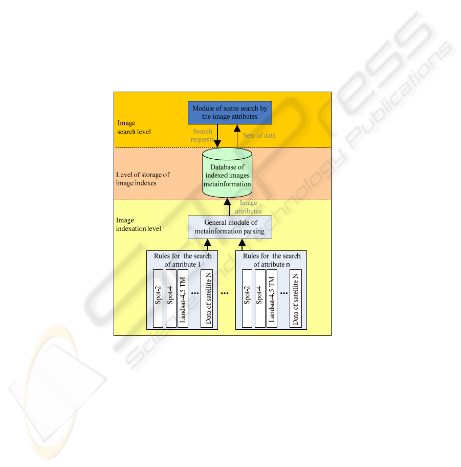
We introduce the architecture of component interaction for a developed database
(Fig. 1).
Fig. 1. The architecture of component interaction for a satellite images database.
Database architecture components are distributed into 3 logical levels: image in-
dexation level, level of storage of image indexes, image search level.
Image indexation level is presented by a module of metadata parsing and the rule
base for metadata parsing.
Level of storage of image indexes is realized as a relational database with geospa-
tial operations support. It is realized as the storage of image metadata and accompa-
nying supplementary information necessary for functioning of the components of
other levels.
31
Module of satellite scene search by image attributes is functioning at the image
search level. The basis of the given module is made of a criteria mechanism connect-
ing user interface, allowing to create search requests, with indexed attributes of the
image stored in the relational database.
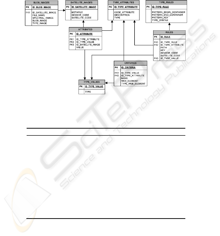
The scheme of the resulting database is presented below (Fig. 2).
Fig. 2. Scheme of the relational database for storage of satellite image attributive information.
A table with description of a database scheme is presented below:
Table 1. The description of database components scheme.
Table name Function
SATELLITE_IMAGES Contains the identifier of each satellite image
(scene) and the accompanying metadata file
saved as a bit sequence
BLOB_IMAGES Contains a quicklook of each scene
ATTRIBUTES Contains attributes for each scene
TYPE_VALUES Is a directory of types of attribute
TYPE_ATTRIBUTES Is a directory of attributes for all the scenes used
for indexation and search
TYPE_RULES Contains templates for lexical analysis of vari-
ous metafile types
RULES Contains the rules for searching attribute types
in a metadata
CRITERIES Contains connections between user interface
elements and the attribute type used for the
scene search
32

4 Process of Dynamic Extension of the Supported Satellites
Nomenclature
Process of expansion of image attributes in RDESI can be described as follows: new-
ly added attribute which gives the possibility of satellite data search realization should
be subjected to preliminary indexation. The process of formalization of rule types
describing the metafile structure template and a set of rules for search of the neces-
sary attribute in each metadata file type was provided for this purpose. Then adding
of new attribute records in the corresponding tables of the relational database is car-
ried out. After that reindexation of the whole image storehouse and selection of a new
(never used before) data attribute is performed. For the possibility of search request
formation and new attribute support there is a new search criterion in user interface
being created which is connected to a new image attribute. One of the predetermined
elements of display in user interface is directed to the given attribute. From the point
of view of a system administrator, it is necessary to point a new attribute in the ad-
ministrator interface, to specify its metafile search rules, to create a new criterion of
search for this attribute and to compare the criterion with the display type in the user
interface.
At adding a new type of satellite data the description of which has the structure
different from the ones already existing, the process is reduced to selection of neces-
sary attributes from a metafile and formalization of rules on their reception.
Here is an example of a part of accompanying metafile structure of the data re-
ceived from satellite “Landsat-7”:
GROUP = METADATA_FILE;
GROUP = ORTHO_PRODUCT_METADATA3
SCENE_UL_CORNER_LAT = +69.3563042
END_GROUP = ORTHO_PRODUCT_METADATA
END_GROUP = METADATA_FILE
Here is an example of attribute receiving rule formalization: “upper left corner of
the image” from Landsat 7 ETM+ (syntax PVL):
select parent container: METADATA_FILE
select child container: ORTHO_PRODUCT_METADATA
select key value: SCENE_UL_CORNER_LAT
Formal record of the rule for the given example in the database is as follows (Ta-
ble 1 and Table 2):
Table 2. Part of table “TYPE_RULES”.
PATTERN_BEGIN
_CONTAINER
PATTERN_END
_CONTAINER
PATTERN_KEY
GROUP = {0} END_GROUP = {0} {0}= {1}
33

Table 3. Part of table “RULES”.
PATH KEY
METADATA_FILE
/ ORTHO_PRODUCT_METADATA3
END_GROUP = {0}
Further, syntactic templates from the table “TYPE_RULES” are filled with values
from the table “RULES” and passed to the module of metainformation parsing.
Accordingly, the process of working out of new modules for new metafile types
analysis is excluded completely from the process of RDESI support and extension.
The exception takes place when appears a metafile storage standard which differ
essentially from the ones already known. In this case it is necessary to add the types
of rules describing the attribute search process in a new metafile type.
5 Conclusions
The technology of dynamic extension of a set of attributes for the search of satellite
image data in a database has been developed. This technology allows to adapt the
image database to the constantly changing external conditions. The technology is
introduced into the database of satellite earth surface images at the Institute of Space
and Information Technologies, Siberian Federal University, Krasnoyarsk.
Acknowledgements
This work was supported by the Ministry of Education and Sciences of the Russian
Federation in the program “Scientific and scientific-pedagogical personnel of innova-
tive Russia for 2009–2013”, lot 1, “Carrying out of scientific researches in the field
of processing, storing, transferring and protection of information by the teams of
scientifically-educational centers” №2009-1.1-214-001-032
References
1. Kussul, N., Rudakova, A.: Development of metadata catalogue for GEO-UKRAINE., Alek-
sey Kravchenko. International Conference “Knowledge-Dialogue-Solutions”. June 18-24,
(2007), Varna (Bulgaria), p. 585-594
2. Zinovyev, V. G., Poletayev, A. M., Prisyajnyuk, S. P.: Problems of standardization in the
field of Earth Remote Sensing. Modern Problems of Earth Remote Sensing From Space
(2007). v. 4, iss. 1. p. 133-137.
3. Tsibulskiy, G. M., Maglinets, Y. A., Latyntsev, A. A., Sirotin, E. E., Maltsev, E. A., Roma-
nov, A. A., Sidorov, A. Y., Brezhnev, R. V., Kurnosov, V. Y., Sosnin, A. S., Perfilyev, S.
Y.: Multi-Purpose Regional System of Earth Remote Sensing at Siberian Federal Universi-
ty. Problems of Region Information, Krasnoyarsk, Nov. 2-3, (2009). p. 22-26.
34
