
Mobile Information System for Species Localization
and Modelling Applied to the Amazon Forest
Álvaro Silva
1,2
, Marcelo Queiroz Leite
2
and Pedro Luiz Pizzigatti Corrêa
2
1
Nokia Institute of Technology (INdT)
Av. Torquato Tapajós, 7200, Col. Terra Nova, Manaus, Brazil
2
PCS, Escola Politécnica, Universidade de São Paulo (USP)
Av. Prof. Luciano Gualberto, São Paulo, Brazil
Abstract. Species distribution modelling based on ecological niche uses data
collected in the field by researchers which indicates whether a particular species
is present or absent. However, without reliability or accuracy, the generated
models are inaccurate. Because of this we propose a system which uses a smart
phone and a service oriented approach to data collection. Using this, a
researcher can submit data collection points for processing on remote servers
which will return the distribution model after it has been previewed. It
automates the collection and modelling process and allows collaboration
between the researchers, but the system needs to be designed giving some
considerations to the often hostile local environment in which it will operate –
the Amazon Forest. This paper presents the benefits of using SOA (Service
Oriented Architecture) to model this kind of system.
1 Introduction
Species distribution based on ecological niche modelling has been used in several
areas of ecology. It uses mathematics techniques which are applied to weather
statistics and other physical factors which can affect the geographic extension of the
species in its ecological niche [1].
So with the known localization data (or absence) of occurrences of individuals
species and relating them to environmental variables (such as relief, climate,
humidity, etc) it is possible to predict the probability that a region will be favourable
to survival of that species.
This process depends on the quality of the data collected in the field. [2] Presents
research concerning the influence of errors in the collection point position. There are,
however, human factors that can also influence the quality of these points.
This paper presents a mobile system which supports the collecting and modelling
of data for the distribution of ecological niche. It also evaluates how mobile devices
can influence the quality of data collected in terms of security, integration, storage
and availability. Beyond this, it proposes a novel approach to help scientists choose an
area in which to collect field data by previewing the models available to the
researcher.
Silva à ˛A., Leite M. and Correa P.
Mobile Information System for Species Localization and Modelling Applied to the Amazon Forest.
DOI: 10.5220/0003029301010108
In Proceedings of the International Joint Workshop on Technologies for Context-Aware Business Process Management, Advanced Enterprise Architecture and Repositories and Recent
Trends in SOA Based Information Systems (ICEIS 2010), page
ISBN: 978-989-8425-09-6
Copyright
c
2010 by SCITEPRESS – Science and Technology Publications, Lda. All rights reserved

2 Distribution Species Modelling
Distribution species modelling is a way of analyzing data which is applied mainly in
biology which uses advanced systems of geographic information [3].
To understand what this modelling represents it is necessary to understand the
concept of ecological niche: according to [4] ecological niche is defined as “a space
with n-dimensional volume where each dimension represents the interval of
environmental conditions or necessary sources for the species survival and
reproduction”.
In [3], ecological niche is defined as a group of ecological condition in which a
species is capable of maintaining population without immigration.
According to these concepts the ecological niche is nothing more than a
determined region where the group of factors favours the species survival.
Environmental features that influence species survival can be temperature, humidity,
salinity, pH, feeding sources, luminous intensity, predatory pressure, population
density, among others. Environmental factors are limited and remain relatively
constant on the interval related to the timeline of these animals [5].
The ecological niche is divided between function and performance. Functional
niche is defined as a group of environmental conditions necessary for a species
survival without considering the influence of predators. Performance niche is where
the species really occurs [6]. You can say that performance niche is a sub-group of
functional one.
Predictive modelling of species distribution is mainly concerned with the
ecological niche modelling. It proposes a solution based on artificial intelligence for
foreseeing a probable geographic distribution of species.
The distribution modelling of ecological niche plays an important role in ecology.
Among the main application are planning for environmental preservation areas [7],
[8], [9]. Choosing a preservation area requires knowledge about a species ecological
niche. With predictive modelling it is possible to identify statistically these areas.
Another area in which modelling is a driving force is in climate change research
[10], [11] which aims to identify how living creatures are affected by global warming.
Other applications can also be found: species replacement in nature, management
of species and habitat, biogeography and others [8].
3 Species Distribution Mobile System
Below we present some features of the proposed system. The case study of the system
has been performed in Amazonas state in partnership with National Institute for
researches of Amazon (INPA) [12].
3.1 The System Importance
The usage of mobile phones for performing data collection offers the following
benefits to the collecting and modelling of ecological niche distribution:
102

Collection automation: A user need only select a button in the geographic
interface to identify a point of presence or absence of a species. Automatically,
the system calculates geographic coordination through GPS (Global Positioning
System) and stores that data. The user will not have to take notes in other
sources or electronic spreadsheet. This also guarantees reliability of the
collected data.
Accompanying changes in the model: With this system it is possible to
follow the mobile phone through the evolution of the model to the extent that
more data can be added, including data from other field researchers.
Better use of a researcher’s distribution: With the simplification of the
system more areas can be analyzed by the researchers. The researcher can work
looking for species in different areas and still can transfer data for all other
researchers to access.
Convenience: The mobile device is more compact thereby reducing the
number of devices necessary to conduct the research.
Usability: A more friendly and intuitive interface will be proposed in this
document. With this system the user will gain some other facilities for
performing data collection such as selecting only one button on the graphic
interface to identify the presence or absence of species.
Faster GPS in regions with GSM (Global System for Mobile
Communications) networks: Modern phones do not use the traditional geo
positioning system, but the Assisted GPS (A-GPS). It is a system that uses a
server for helping to minimize the Time To First Fix (TTFF) and improving the
robustness of the positioning. The accuracy of location is less than 3.1 meters
and the TTFF are less than 5 seconds, working even in situation of critical
satellite signs [13]. The A-GPS uses any available networks such as the GSM
network of the operator or even a wireless network in urban areas. This type of
technology use case is important for the modelling of species which live in
urban environments, such as rats and mosquitoes for example, when identifying
possible diseases routs [14].
3.2 Technical Restrictions
There are two main technical restrictions for the proposed system. They are:
Network availability: One of the biggest challenges this project faces is the
issue of communication between the cellular and the service provider. Most
use cases for a system such as this involve communication networks with
intermittent network access so the system shall work most of the time in off-
line mode. The main objective of the application is in automating the data
collected and its sending to the server. However it is not intended that data
collection occurs at the point of collection but as soon as there is an available
network. Working in off-line mode the application will be able to store the
current coordinates, show saved models and analyze these models.
Processing power of the devices: The predictive modelling of the species
distribution requires high performance computing [14] the generation of a
model can take between hours and days to prepare.
103

3.3 Business Restriction
This type of research in Brazil needs to comply to some rules concerning the transfer
of biodiversity data. This data needs, in many cases, to be kept secret. These measures
are necessary for environmental property protection.
This kind of concern is important for Brazil once which has 20% of the total
number of species on the planet. In august of 2009 the Ministry of Science and
Technology published 'the concierge 693’ which standardizes the manipulation and
distribution of research data about biodiversity. This concierge makes the following
observations:
The management and authorship of data must be published.
The usage condition and the access to data must be protected in the database.
3.4 Usability
The system needs to have easy browsing, be intuitive and have few steps necessary
for performing tasks. The kind of device that is being proposed for use is a Smart
phone, which has a limited screen size. That means that the icons need to be arranged
in such to be very easy to use. Fig. 1 shows the screen of the main menu of this tool in
a mobile device.
Fig. 1. Main Menu in a mobile device demonstrating the usability with the thumbs.
This interface shows how efficient it is for small devices that have touch screens.
Usage of the thumbs allows for a more comfortable experience. Fig. 2 shows the
flowchart of initial activities with skeleton of the screens.
104
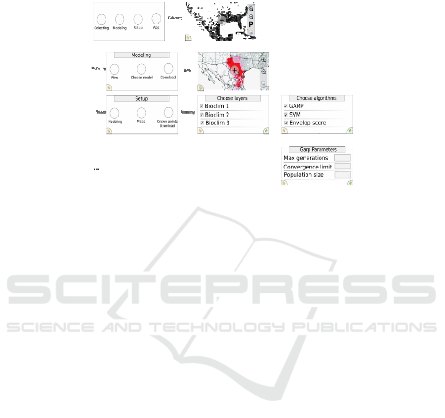
Fig. 2. Flowchart for some screens of the system.
4 SOA to Mobile Species Distribution Modelling
SOA was chosen as the distribution mechanism due to the challenge of having access
to a distribution model via mobile phones. Using this system the following use cases
were identified as services and offered by the providers:
• Environmental data provider;
• Maps provider;
• Species data provider;
• Modeling algorithms provider;
• Pre-modeling algorithms provider;
• Post-analysis algorithms provider.
At Fig. 3 is shown the architecture proposed by this paper.
Basically, an infra-structure with a set of servers is used. Each of the offered
services can be available in different servers. The mobile devices will have access to
these services at the moment they are in regions with Internet access, having Wi-fi,
GSM or any other kind of connection. Most of the collected data happen in remote
regions, without this kind of infra-structure. For this reason, the system runs in two
working modes: connection with or connectionless. The connection with mode is used
for transferring data between the mobile devices and the service providers. While the
connectionless mode is used mainly while the researcher in field looking for points of
species presences or absences. In this mode the data persists on the device.
Before the data can be transferred, the information is first checked by an active
service on the device itself, this service aims to perform a pre-processing of
information in order to ensure the integrity of data being made available to other
modules. If the information is not corrupted, it is transmitted through a provider of
105
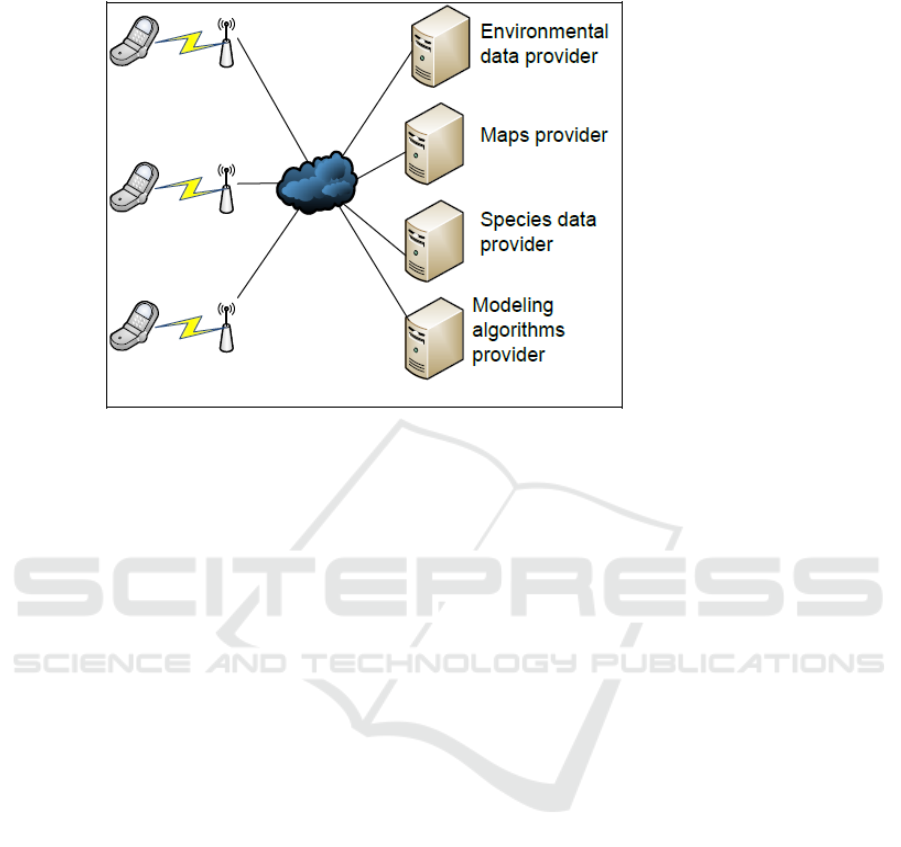
Fig. 3. Services used for species distribution modelling.
communication services to an intermediate server. If the device is operating off-line
this information is stored on the device itself, until it has access to any network. To
receive the information collected by the device, the intermediary service provider is
engaged to provide this content to a number of providers of services, each with a
separate responsibility within the architecture, so that at the end of execution this data
can be made available to a service provider responsible for ensuring the persistence of
information processed in a server database.
Through the use of services, the SOA model provided the project a coherent
distribution of resources in infrastructure. Despite the technical constraints (section
3.2) the use of the Internet has provided an efficient way to transfer the data collected
with the service providers in a quick and dynamic manner.
This service oriented architecture allowed us to solve the following issues:
• High performance computation on a mobile phone: Although mobile phones
do not have enough capabilities to perform distribution modelling, it was
possible to show a model on the device due to the use of services.
• 6yReuse of existing services to composition of many solutions: Some services
used on this project are from the Openmodeller project and others from
SpeciesLink. They obtain from the services models and data concerning the
presence or absence of a species.
• Use of web services to provide fast software updates: With this approach each
research team is able to get the current data that all other teams have collected.
Without this system the update can only be done after the team come back to
the base. Another feature of this project is the ability to do upgrades on the
software.
106

5 Conclusions
The system proposed in this paper allows a user to preview the distribution models of
ecological niche using a low computational power mobile device. It was verified that
mobile devices are powerful enough to make previewing the model possible, given
the service orientated system architecture. It was even possible using communication
with remote servers.
We also show that an opportunity exists for data collection given a crowd sourcing
approach
The automation of data collecting through a mobile device is important as it
reduces human intervention in a system. Further research is necessary to measure the
quantity and quality of the collected data with this system.
The service oriented architecture shows that it is efficient in this type of project.
Modelling species distribution in a distributed manner through the use of services in
different servers is an interesting use case for Service Oriented Computing.
References
1. Soberón, J. & Peterson, A.T., 2005. Interpretation of models of fundamental ecological
niches and species' distributional areas. p.10.
2. Iwashita, F., 2008. Sensibilidade de modelos de distribuição de espécies a erros de
posicionamento de dados de coleta. Instituto Nacional de pesquisas espaciais.
3. Peterson, A.T., 2001. Predicting species geographic distributions based on ecological niche
modeling. Cooper Ornithological Society.
4. Hutchinson, G.E., 1957. Concluding remarks. Cold Spring Harbor Symposia on
Quantitative Biology, pp.415-27.
5. Bazzaz, F.A., 1998. Plants in changing environments: Linking physiological population, am
community ecology. Am community ecology.
6. Malanson, G.P., Westman, W.E. & Yan, Y.-L., 1992. Realized versus fundamental niche
functions in a model of chaparral response to climatic change. Ecological Modelling,
pp.261-77.
7. Austin, M.P., 2002. Spatial prediction of species distribuition: an interface between
ecological theory and statistical modelling. Ecological modelling Elsevier, pp.101-18.
8. Guisan, A. & Zimmermann, N.E., 2000. Predictive habitat distribution models in ecology.
Ecological modeling, pp.147-86.
9. Sohn, N., 2009. Distribuição provável, uso de hábitat e estimativas populacionais do galo-
da-serra (Rupicola rupicola) com recomendações para sua conservação. Universidade
Federal do Amazonas.
10. Peterson, A.T. et al., 2001. Effects of global climage change on geographic distributions of
Mexican Cracidae. Ecological modelling, pp.21-30.
11. Canhos, V. et al., 2005. A framework for species distribution modeling. Research project.
São Paulo: Reference Center in Ambiental Informatics, USP Polytechnic School, National
Institute of Spacial Research.
12. INPA, (2010). Instituto Nacional de Pesquisas da Amazônia. Retrieved September 1, 2009,
from http://www.inpa.gov.br.
13. SCHREINER, K., 2007. Where We At? Mobile Phones Bring GPS to the Masses. IEEE
Computer Graphics and Applications, 27, pp.6-11.
14. Santana, F.S., Siqueira, M.F., Saraiva, A.M. & Correa, P.L.P., 2008. A reference business
process for ecological niche modelling. Ecological informatics 3, pp.75-86.
107
