
A SOFTWARE FRAMEWORK TO SUPPORT AGRICULTURE
ACTIVITIES USING REMOTE SENSING AND HIGH
PERFORMANCE COMPUTING
Shamim Akhter and Kento Aida
National Institute of Informatics (NII) and Tokyo Institute of Technology (TITECH), Tokyo, Japan
Keywords: Agriculture, Remote Sensing (RS), High Performance Computing (HPC), Web Portal.
Abstract: Agricultural activity monitoring, enclosed quantifying the irrigation scheduling, tracing the soil hydraulic
properties, generating the crop calendar etc., is very important for ensuring food security. Farmers want to
know these information in a regular basis. Additionally, large scale agricultural activity monitoring requires
to congregate information from Remote Sensing (RS) images and that type of processing takes a huge
amount of computational time. Thus, optimization on the computational time is a vital requirement. In such
cases, High Performance Computing (HPC) can help to reduce the processing time by increasing the
computational resources. Moreover, web based technology can contribute an understandable, efficient and
effective monitoring system. Still, the merging domain researches on RS image processing, agriculture and
HPC are mainly in hypothetical or conjectural theme rather than practical implementation. Thus, this
research contributes a new software system to support agriculture activities in real time using both RS and
HPC. The main purpose of the system is to serve the valuable crop parameters information to the farmers
through a web base system in real time. Additionally, we are going to discuss in details about the
implementation issues of the proposed software system.
1 INTRODUCTION
Agriculture activity monitoring or prediction on crop
parameters such as crop growth in terms of planting
date, date of emergence, extents, acreage, planting
intensity, water stress, biomass, yield and etc. is
important. It can contribute to better policymaking,
timely countermeasures, optimization of water
resources distributions, damage assessment and
finally to supply food security. Particularly, when an
on-going experiment covers large area such as a
country, satellite imagery plays a vital role by
providing useful information. However, some
information, or crop parameters, is not visible
through satellite images, which reflects a practical
problem that we can not generate or observe those
parameters from remote places. Indirect method such
as inverse modelling technique with crop model can
solve the problem. However, processing the inverse
modelling with crop model has a problem in
practicality, that is, they require a huge amount of
processing times. It becomes necessary to introduce
methods for using higher processing power such as
High Performance Computing (HPC) technologies.
Some protocols or tools have been developed
concerning the inverse modelling techniques and
their HPC implementation models. However, the
interoperability protocol between those agriculture
applications and existing remote sensing (RS) image
processing software is also necessary to improve
practicality. Thus, a software framework is required
which will make the successful interconnection
between the inverse modeling techniques, the RS
image processing and the HPC technology. In this
study, we are going to propose such web based
software framework to support the agriculture
activity monitoring system. Additionally, the
framework implementation issues or the difficulties
for such framework implementation will be
discussed in this paper.
210
Akhter S. and Aida K. (2010).
A SOFTWARE FRAMEWORK TO SUPPORT AGRICULTURE ACTIVITIES USING REMOTE SENSING AND HIGH PERFORMANCE COMPUTING.
In Proceedings of the 5th International Conference on Software and Data Technologies, pages 210-213
Copyright
c
SciTePress

2 BACKGROUND
2.1 Inverse Modeling Techniques
Crop models, Soil-Water-Air-Plant (SWAP) (Van
Dam et al., 1997) or Decision Support System for
Agrotechnology Transfer (DSSAT) (Tsuji et al.,
1994), have capacity to simulate soil, water and crop
processes and serve as crop productivity monitoring
tool. Crop Assimilation Model (CAM) predicts
parameters of crop models with satellite images. A
new methodology was developed in (Ines, 2004),
CAM-GA, to analyze the crop model (SWAP)
parameters assimilation with Remote Sensing (RS)
data and that parameters assimilation procedure was
optimized by an evolutionary searching technique
called Genetic Algorithm (GA). CAM with double
layers GA, CAM-DLGA, uses directly visible multi-
resolution RS images (ASTER Image Webpage, 2009)
(MODIS Image Webpage, 2009) and inversely
assimilates to SWAP model data for estimating the
non-visible model parameters. Other similar
functionality models, e.g., CAM-PSO (Kamble and
Chemin, 2006) and CAM-PEST (Dorji, 2003), use
different evolutionary searching techniques.
However, processing the agricultural information
with CAM has a problem in practicality, that is, they
require a huge amount of processing times. It
becomes necessary to introduce methods for using
higher processing power such as High Performance
Computing (HPC) technologies.
2.2 HPC Implementation Issues
Multi computer based distributed systems (Clusters
and Grids) have a large processing capacity for a
lower cost, naturally, choice turns towards
developing HPC applications. However, it is not an
easy job to port CAM in HPC environment. The
application performance is significantly affected by
the data and task distribution methods on the HPC
and developers of agriculture or satellite image
processing applications need to solve the problem of
both data and task distribution, or how to distribute
data and tasks among single or multiple clusters
environment. The workload in HPC, the bandwidth,
the processors speed, parameters of evaluation
methods and data size are additional concerning
factors. Moreover, interoperability between the
agriculture application and existing RS image
processing software is also necessary to improve
practicality. However, users need to manually extract
satellite data from some databases in the existing
CAM works. Thus, agricultural researchers require a
software or tool for the agricultural activity
monitoring so that they do not need to concern about
the implementation issues for agricultural models or
RS image processing on HPC.
3 PROPOSED FRAMEWORK
Figure1 presents the essential components during the
building phrase of the proposed system, e.g.,
combines the agriculture applications with RS image
processing tools, models them for HPC and then
interacts with web tools. The objective of this
research is to develop a complete HPC system or
tool for CAM to identify the crop parameters from
satellite image. The overall realistic architecture of
the proposed tool is presented in Figure2 and the
designing steps consists “processing satellite images
automatically through HPC”, “CAM HPC
implementation with appropriate data and task
distribution schemes”. Individually, each step has
been discussed and implemented with different data
and application domains in (Akhter et al., 2007) and
(Akhter et al., 2008). GRASS GIS (GRASS GIS,
2009) tool has been used to process the satellite
images automatically. CAM has been implemented
as a GRASS module. The interconnectivity between
the GRASS on HPC platform has been successfully
established and then the GRASS CAM module has
been implemented in HPC platform with different
data and task distribution methods. However, their
combined framework for modeling the overall
distributed agriculture monitoring scheme has not
yet been established. Web based portal system on
HPC for processing RS images protocol need to be
established and that will merge those issues together
into a unique platform. An excellent, fast and
flexible open source mapping web software is
UMN/MapServer (GRASSMAP, 2009). WMS (Web
Map Service), is on online access to, or integration
and exploitation of geospatial information, was
successfully implemented in (Ninsawat, 2004) with
FOSS (Free Open Source Software) to provide
satellite image server. GRASSLink (Huse, 1995), a
UNIX shell script based model, is capable to access
spatial information from GRASS datasets and
displayed necessary parameters in web through web-
mapping applications. However, those works
provide the mapping concept on static image
environment. However, in the proposed framework,
the image provider can be from different domains
and then automatic data updating process will be a
vital requirement. Thus, an interconnection between
the domains is required with necessary security
A SOFTWARE FRAMEWORK TO SUPPORT AGRICULTURE ACTIVITIES USING REMOTE SENSING AND HIGH
PERFORMANCE COMPUTING
211
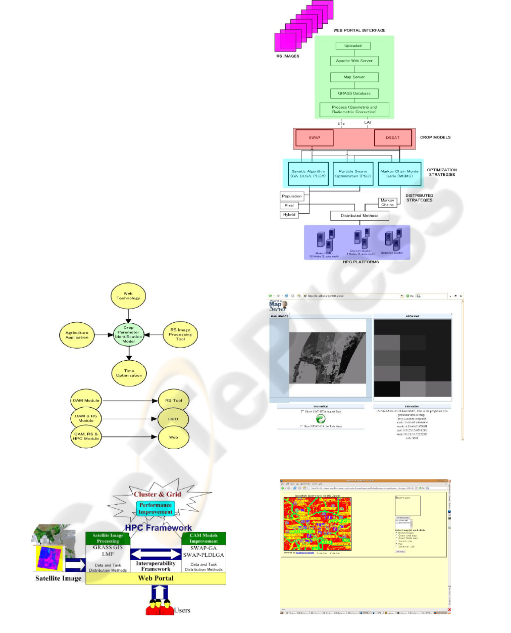
infrastructure. Figure 3 presents the web based
architecture for the proposed framework. Openlayer
(OpenLayer, 2009) or PyWPS (PyWPS, 2009) can
be a solution on that circumstance. In our proposed
methodology, we are going to select PyWPS, as it is
relatively new concept and easy to create connection
with GRASS. Additionally, PyWPS supports to
create dynamic GRASS location for a given input
image during the executable phase, makes the task
easier for sharing input images from another
repository. Two separate modules for client and
server will be provided. In the server module, the
CAM modules with GRASS GIS supporting
environment and the HPC implementation for data
distribution and task distribution schemes will be
available. Whereas, in the client module, the user
interface will be provided. User can select the
specific region from a given image through the
interface. XML based parser system will trace the
user given queries and submit those queries to the
server modules. Server module will execute the
GRASS based CAM module with user given queries
and generate unknown crop information; those are
not directly extractable from RS images.
Figure 1: Essential Components to Build the Framework.
Figure 2: The Overall Realistic Architecture.
Figure 3: The Web based Architecture Framework.
Figure 4: The UMN Mapserver based Static Image
Environment.
Figure 5: PYWPS based Agriculture System in Web.
ICSOFT 2010 - 5th International Conference on Software and Data Technologies
212

4 RESULTS
Figure 4 presents the UMN Mapserver based static
image environment and here user can watch only the
predefined and preprocessed images. The images
will not be possible to change without defining the
new images inside the map files. Figure 5 presents
the expected PyWPS based agriculture system in
web. User can select the specific region to execute
the agriculture model and then the agriculture model
will process the input image and generate the outputs
as images in the user interface. This example is a
PyWPS demo implementation for CAM models. The
entire software framework is in the developing phase.
In near future, the fully automated software will be
provided as a package or tool with the support of the
following implementation issues: a) The RS image
and the crop data will be automatically shared from
the RS and agriculture data repository, b) users don’t
need to bother about the backend processes like the
crop models or HPC or the distribution mechanisms,
c) the expected time for processing image will be
within few hours range, and d) multi-users can
interact in the system at the same time. So, the portal
must be capable to serve multi users processing
requests.
5 CONCLUSIONS
This type of work will merge the RS based
agricultural system with HPC and can be a model
application for distributing the RS and agriculture
field of study. Specially, this is the first effort to
implement CAM-GA, CAM-DLGA, LMF and
GRASS on top of HPC to provide the time
optimization. The successful implementation of this
research can be extended to city or provincial level,
helps the policy makers to monitor the on field
agriculture behavior and take prompt decision and
action regarding any unusual condition. The
extended version of the software with necessary crop
model input data and RS image can capable to
monitor any provincial or country level agricultural
activities.
REFERENCES
Akhter, S., Chemin,Y., Aida, K., 2007, Porting a GRASS
raster module to distributed computing: Examples for
MPI and Ninf-G, OSGeo Journal, Vol2., pp.36-44.
Akhter, S., Osawa, K., Nishimura, M., and Aida,K., 2008,
Experimental Study of Distributed SWAP-GA Models
on the Grid, IPSJ Transactions on Advanced
Computing Systems, Vol.1 No.2, pp.193-206.
ASTER Image Webpage, 2009,
http://asterweb.jpl.nasa.gov/, Internet.
Dorji, M., 2003, Integration of SWAP Model and SEBAL
for Evaluation of on Farm, Irrigation Scheduling with
Minimum Field Data, Enschede, ITC, 100 p.
GRASS GIS, 2009, Geographic Resources Analysis
Support System, http://grass.itc.it/, Internet.
GRASSMAP, 2009, Simple demonstrational
GRASS/UMN/MapServer (Spearfish data),
http://grass.itc.it/start.html , Internet.
Huse, S.M., 1995, GRASSLinks: A New Model for Spatial
Information Access for Environmental Planning, PhD
Thesis, University of California, URL:
http://www.regis.berkeley.edu/sue/phd/, Internet.
Ines, A.V.M., 2004, Improved Crop Production Integrating
GIS and Genetic Algorithms, PhD Thesis, Asian
Institute of Technology (AIT), Khlong Luang,
Bangkok, Thailand, AIT Diss No.WM-02-01.
Kamble, B., Chemin, Y.H., 2006, GIPE in GRASS Raster
Add-ons, http://grass.gdf-hannover.de/wiki/,
GRASSAddOns, RasterAdd-ons, Internet.
MODIS Image Webpage, 2009,
http://modis.gsfc.nasa.gov/, Internet.
Ninsawat, S. and Honda, K., 2004, Development of
NOAA and Landsat Image Server using FOSS,
Proceedings of the FOSS/GRASS Users Conference,
Bangkok, Thailand.
OpenLayer, 2009, OpenLayers: Free Maps for the Web,
http://openlayers.org/, Internet.
PyWPS, 2009, Python Web Processing Service,
http://pywps.wald.intevation.org/, Internet.
Tsuji, G.Y., Uehara, G., and Salas, S., 1994, DSSAT v3.0.,
Honolulu, Hawaii: University of Hawaii.
Van Dam, J.C., et. al., 1997, SWAP Model,
http://www.swap.alterra.nl/, Internet.
A SOFTWARE FRAMEWORK TO SUPPORT AGRICULTURE ACTIVITIES USING REMOTE SENSING AND HIGH
PERFORMANCE COMPUTING
213
