
A WEB-BASED TOOL FOR SPATIOTEMPORAL FILTERING
AND CONTINUOUS ANIMATION
Alex Vakaloudis and Simeon Veloudis
TEI Serron, Terma Magnisias, Serres, Greece
Keywords: GIS GUI, Spatiotemporal navigation, Spatial-temporal filtering.
Abstract: We describe MoveMap, a front-end tool for spatiotemporal databases with moving objects. Built over the
Google Maps technology, is independent of any underlying data model or query language. It accommodates
continuous temporal navigation and aims to both precision and abstraction by employing the Google Maps
DirectionsService utility. For filtering and controlling the display, it includes a set of spatiotemporal
operators that can be dynamically triggered, as the navigation proceeds in time. Spatiotemporal querying is
thus performed in two different layers; first at the server level which can be accomplished by any underlying
framework and second on the client through this mechanism of associating query conditions to browser
events.
1 INTRODUCTION
The web and technologies such as Google Maps are
increasingly becoming a very interesting medium for
the dissemination and processing of geographical
information. In this paper we focus on maps with
moving objects. This type of maps typically concern
location-based services for applications such as
surveillance (Hilton, 2006) and transportation and
navigation (Wolfson and
Bo Xu, 2010).
The importance of web-based maps is underlined
by the continuous evolution of products by
commercial giants, Bing Maps by Microsoft and
Google Maps. The latter comes with a JavaScript
API, currently in its 3rd version, which includes
modelling of spatial data types such as points, lines
and areas, spatial overlays, zooming and geocoding.
Nevertheless, the absence of any built-in
provisions for spatiotemporal data types is
remarkable and largely motivates the work presented
in this paper. A mechanism that demonstrates
moving objects on Google maps appears in
(Williams, 2010). Although it is not database-driven,
it verifies that this technology can form the
foundation for an interface to a spatiotemporal
database. Google Earth, does includes temporal
support in KML via a time slider control which
displays discrete transitions in the movement of
points or the shape of lines/polygons.
The ArcGIS server provides a web interface with
support for time-varying data. Change is discrete
and hence it does not cover any continuous
movement.
Apart from Google Maps, other efforts on web-
based GIS have used applets (Voss and Andrienko
and Andrienko and Gatalsky, 2001), Flash (Brannan,
et al., 2008) or other plug-ins at the client side.
Research on web-based moving objects for GIS
includes the work of (du Mouza and Rigaux, 2002)
who stresses the importance of continuous queries.
Later efforts on Google Maps are Geotracker (Chen,
et al., 2007) that visualises RSS events according to
their timestamp and Temp-o-map (Kauppinen and
Deichstetter and Hyvönen, 2007). However, these
efforts deal with objects with discrete temporal
characteristics (e.g. World Cup events) and thus do
not cater for the animation of moving points.
From a system structure point of view, with the
ever-increasing growth in processing power, the thin
clients of previous web-based GIS systems are
becoming “thicker” and equipped with more
services like spatial navigation, data filtering and
layering (Khan, 2010) (Horal, et. al., 2006). This
provides better interaction with spatiotemporal data
through local data manipulation (Hilton, 2006).
The objective of this work is twofold:
1. To control spatiotemporal navigation and
display continuous movement of points with the
optional use of DirectionsService utilities through
399
Vakaloudis A. and Veloudis S..
A WEB-BASED TOOL FOR SPATIOTEMPORAL FILTERING AND CONTINUOUS ANIMATION.
DOI: 10.5220/0003335703990403
In Proceedings of the 7th International Conference on Web Information Systems and Technologies (WEBIST-2011), pages 399-403
ISBN: 978-989-8425-51-5
Copyright
c
2011 SCITEPRESS (Science and Technology Publications, Lda.)
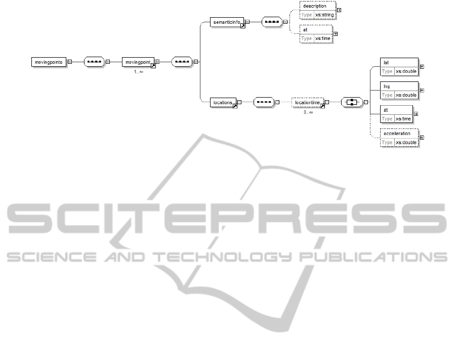
Figure 1: The MoveMap XSD schema for interacting with the application server.
the use of Google Maps as a front-end to a three-tier
architecture. In the proposed scheme, the web-based
client relays any queries to the underlying database
through AJAX calls generically, i.e. independently
of any specific spatiotemporal data implementation
or query operators.
2. To optimise performance by including at the
client-side an engine for spatiotemporal querying
that will reduce the number of calls to the server.
The client is thus no longer confined to a thin model
with display-only capabilities.
To this end we propose MoveMap, a front-end
tool for displaying the contents of spatiotemporal
databases with moving objects.
2 ACCESS TO DATA MODEL
Over the past fifteen years a proliferation of spatio-
temporal data models backed by query operators
have been proposed (Guting and Schneider, 2005).
Here we do not propose yet another such model;
instead, we focus on the visualisation of
spatiotemporal data and on controlling their display.
The MoveMap tool lies on the top-tier of a
typical 3-tier architecture and communicates with
the server/application tier which in turn is
responsible for connecting to a database with
spatiotemporal data. These data are converted to an
XML feed which is subsequently sent to the client.
The choice of XML is made for simplicity: we could
similarly use JSON or web services to achieve
equivalent results or even increase performance. An
XSD schema (Fig.1) is thus defined to receive query
results. The principal concept is the spatiotemporal
point (locationtime) consisting of two spatial
coordinates and a temporal timestamp. The last
element of locationtime is the optional acceleration,
introduced for the enhanced representation of
movement. A movingpoint is defined as the
composition of spatial and non-spatial evolution, in
other words it is made up by a sequence of
locationtime elements and a sequence of
semanticinfo elements. The latter signifies any
application-specific semantics associated to a
moving point. Overall, the entire query result is
represented by a set of movingpoint elements, the
root element movingpoints,
3 ARCHITECTURE
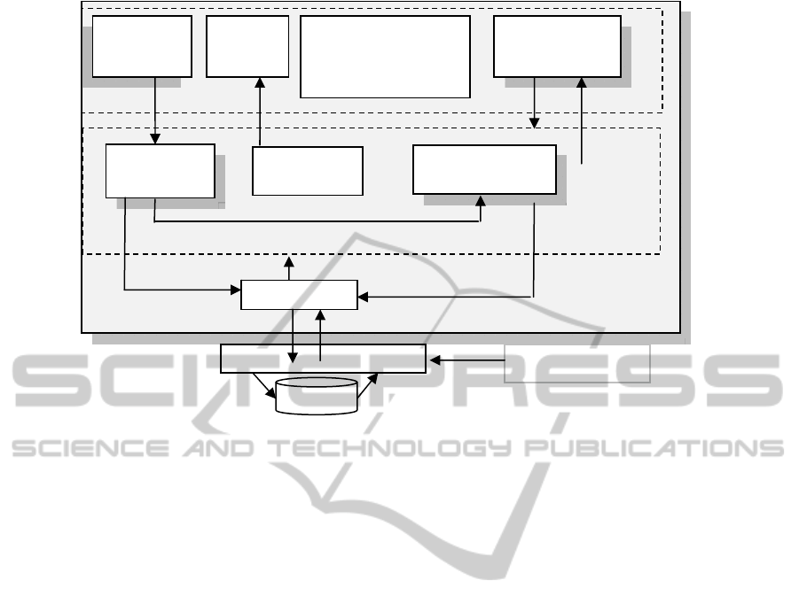
Fig. 2 illustrates the architecture of MoveMap and its
placement within a web-based GIS. We concentrate
on the client tier. The display of a Google Map is
augmented with two GUIs: one for temporal
controls and one for the definition/monitoring of
spatiotemporal operators.
Underlying are two engines implemented as
JavaScript APIs: the Movement Engine responsible
for updating the positions of points in the map and
the Spatiotemporal Query Engine which controls the
contents of the map and the interaction with the user
through appropriate notifications.
Any data used are in the form of a JavaScript
array of moving points (available to all modules)
produced by a Connector module that communicates
with an Application Server to receive query results.
3.1 Animation of Moving Objects
3.1.1 Temporal Controls
Spatial navigation and spatial zoom are already
handled by Google Maps GScaleControl. For
temporal navigation, similar to previous approaches,
we provide a slider, a clock and temporal navigation
WEBIST 2011 - 7th International Conference on Web Information Systems and Technologies
400
manage manage
Browser
populate
notify
position_changed event
Array of Moving Objects
temporal spatiotemporal query
window update
data request query result XML/JSON MoveMap
DBMS
Figure 2: MoveMap Architecture.
controls. MoveMap supports multiple granularities
and the choice is made in the configuration manager.
The user queries the database through a textual
window. The decision to leave this utility in simple
textual format is made because the use of a visual
interface would mean reliance on a specific spatio-
temporal query extension and loss of generality.
3.1.2 Supported Movement Modes
To achieve a more realistic presentation of the
movement and produce more precise calculations it
is important not to confine to simply showing
objects at the recorded timestamps. For this reason
MoveMap supports three modes of movement:
a) Index: A sequence of points with timestamps are
given and objects are displayed when the
respective timestamp is reached. Transition from
one location to another is discrete. This type of
movement is currently supported by Google
Earth and has been extensively studied.
b) Continuous: A point is shown moving on a
straight line between two successive pairs of
timestamped coordinates in a manner specified
by the acceleration property.
c) Road based: As in the continuous mode, but its
route relies on Google Maps DirectionsService
utility to identify the path followed instead of
moving in a (non-realistic) straight line.
The last mode is the most interesting one and
has not been used – to the best of our knowledge -
by any web-based GIS. It offers simplicity since
only two points are required to depict larger spatial
variations and accuracy as an object is moving al-
ong roads hence correcting any erroneous margins in
its recorded position. For objects moving along
roads the distances calculated are more realistic than
the continuous mode. Yet, since path marking is
delegated to Google Maps this approach cannot
assure the yielding of the desired route.
3.1.3 Movement Engine
The movement of objects is implemented as a
JavaScript timer (setTimeout()). A moving point is
represented by a Marker and at each clock tick an
updated position is calculated through the accelera-
tion property and movement type. Updating a
position raises a Marker class position_changed
event consumed by the query engine.
When the Road-based movement is preferred and
the Google Maps DirectionService is called, the
results are stored in a cache array for later use. This
is essential not only since getting Google Map
Directions is a time consuming process but there
also exists currently a limit on daily use.
Moving
Objects
Map
Temporal
Controls
GUI
Movement
Engine
Spatiotemporal
Query Operators
GUI
Spatiotemporal
Query Engine
Connector
Google Maps
API
Application Server
Feeding System
User Tools:
Configuration Manager
Query Window
Log Window
A WEB-BASED TOOL FOR SPATIOTEMPORAL FILTERING AND CONTINUOUS ANIMATION
401
3.2 Spatiotemporal Querying on Client
Level
3.2.1 Spatiotemporal Client Query Engine
The Query Engine facilitates querying of moving
objects at the client-side. Having an application that
does not rely entirely on a server for data
manipulation and filtering, increases usability and is
nowadays feasible because of increased computer
performance and advanced browser scripting.
Obviously this does not eliminate the need for
getting data from the database. However, the user
issues queries less times to a server and uses the
client controls to revise the display.
The engine is implemented through DOM events
that are fired when certain conditions are met. It
takes as input the position_changed event specified
for the Marker class in the Google Maps API. This is
fired every time the moving engine changes the
position of a moving point as it progresses with
temporal navigation. A set of spatiotemporal event
listeners process this event to check the satisfaction
of the query conditions and notify the user
accordingly.
Since spatiotemporal operators are evaluated at
every tick of the clock, their satisfaction becomes
observable only when the temporal navigation
reaches the timestamp of activation. Thus navigation
up to a certain timestamp is required to trigger the
display of an operator’s result.
3.2.2 Spatiotemporal Operators
For assisting the web-user in querying at the client-
level we define a set of spatiotemporal listeners to
correspond to spatiotemporal conditions. We
concentrate on spatiotemporal criteria that have both
spatial and temporal conditions to cover
spatiotemporal behaviour. This set can obviously be
augmented; its purpose is to provide a standard set
of querying channels and to demonstrate the
feasibility of processing queries at the client-side.
We cover the following spatiotemporal queries:
• snap shot queries (where was I at 3:45) and
window queries (between 4:45 and 3:50)
• clustering queries (how many around the city)
• association queries (who was here before me)
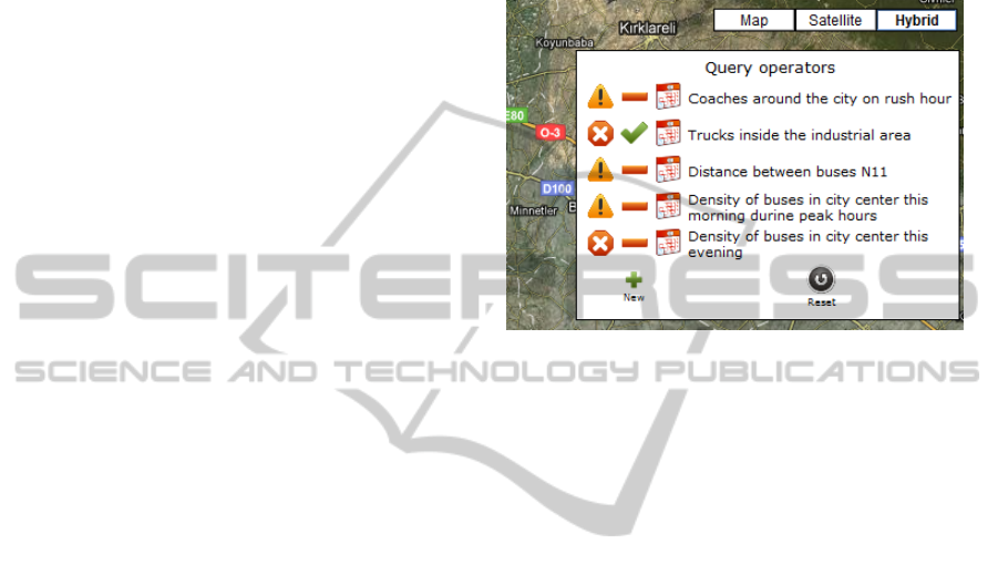
3.2.3 New Spatiotemporal Query Operators
Defining a new query operator is a two step-process:
First, the user specifies the operator by giving a
name and choosing its type. According to this type,
additional data are required, for instance for the
proximity (circle) operator the radius and position of
the circle. The operator may be applicable to a
certain time window. Second, in the map display, the
user selects the markers applicable to the operator by
double clicking on them. Google Maps supports
clickable markers and assigns them to the arguments
of the operator.
Figure 3: An example of a list of spatiotemporal operators.
3.2.4 Notification Levels
Applying the browser capabilities in conjunction
with the special features of a moving objects map,
MoveMap defines six leve ls of user notifications:
• Simple text notification in the log window.
• The temporal navigation ceases
• JavaScript alert
• Spatiotemporal zoom.
• Change of the status of the marker in the map:
Show/hide, flash or highlight the marker.
• Display of Overlay (Circle or Rectangle).
3.3 Communicating with Server
The Connector module is responsible for issuing
query commands to the application server, receiving
the query results in XML format and producing
arrays of moving objects. It is important to design a
Connector module to manage the size of the
incoming XML and the number of displayed points
since a map with a large number of markers may
crash or freeze.
The Connector also informs the server of the
maximum concurrent number of moving points it
can handle. If the number of query results exceeds
this limit, they are sorted in time order and are partly
returned. If the user’s temporal navigation
approaches or exceeds the upper timestamp of the
partial query result, the Connector informs the
application server so as to receive the next patch of
WEBIST 2011 - 7th International Conference on Web Information Systems and Technologies
402
results. Communication is performed by AJAX calls
without the need for user intervention.
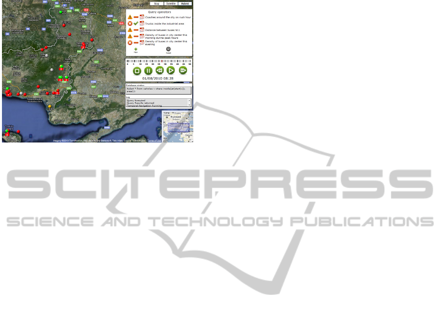
Figure 4: Monitoring the movement of coaches.
4 CONCLUSIONS AND FUTURE
WORK
In this paper we presented a Web interface for
applications with moving objects lying on Google
Maps. It includes continuous DirectionsService-
based animation and improves user experience with
a set of spatiotemporal operators on the moving
objects. These operators are activated on the fly i.e.
as the display fluctuates dynamically in time and
their inclusion constitutes an effort to make an
already easily accessible interface of Google maps
more self-sufficient in terms of queries to the
application server.
Currently, this system is being used to monitor
the operation of coaches in the Thrace region of
Greece. Their positions are recorded by staff and
imported to the database. The managers check
punctuality, speed and distance between coaches as
well as track stoppage times.
Future work involves extension of continuous
animation to line and polygon data types and the
exploitation of the XSD to visualise mutations on
non-spatial attributes. Moreover, we investigate
spatiotemporal clustering in terms of visualisation
and client-based querying.
REFERENCES
Brannan S., Evens N,. Barnett C., Deyneka L., Ising A.,
Wheaton B. 2008. Web-Based Spatio-Temporal
Display of NC DETECT Surveillance Data. Advances
in Disease Surveillance, 5(1), 6.
Chen Y.F., Di Fabbrizio G., Gibbon D., Jana R., Jora S.,
Renger B, Wei B. GeoTracker: Geospatial and
Temporal RSS Navigation. In WWW ‘07 Proceedings
of the 16th international conference on World Wide
Web, 2007
Guting R.H and Schneider M. (2005). Moving Objects
Databases, Morgan Kaufmann
Hilton B.N. 2006. Open Source Software, Web Services,
and Internet-based Geographic Information System
Development. CaGIS 32(4)
Horak J., Unucka J., Stromsky J., Marsik V., Orlik A.
2006. TRANSCAT DSS architecture and modelling
services. Control and Cybernetics 35(1)
Kauppinen T., Deichstetter C., Hyvönen E., Temp-O-
Map: Ontology-based Search and Visualization of
Spatio-Temporal Maps. In ESWC 2007, Innsbruck,
Austria, 2007
Khan Z.A. 2010 Usability Evaluation of Web-based GIS
Application. Master Thesis. School of Computing
Blekinge Institute of Technology, Sweden
du Mouza C, Rigaux P, Web Architectures for Scalable
Moving Object Servers. In 10
th
ACM-GIS'02, Virginia,
USA, 2002
Voss H., Andrienko N, Andrienko G, Gatalsky. 2001.
Web-based Spatio-Temporal Presentation and
Analysis of Thematic Maps. The Journal of Cities and
Regions, Journal of SCORUS, the Standing Committee
on Regional and Urban Statistics and Research. Nov.,
51-61
Williams M. (n.d.), Using the Google directions for an
animated drive. Retrieved September 1, 2010, from
http://econym.org.uk/gmap/example_cartrip.htm
Wolfson O., Bo Xu B. Spatio-temporal Databases in
Urban Transportation. 2010. IEEE Data Eng. Bull,
33(2)
A WEB-BASED TOOL FOR SPATIOTEMPORAL FILTERING AND CONTINUOUS ANIMATION
403
