FOUR ASPECTS OF RELEVANCE IN SHARING
LOCATION-BASED MEDIA: CONTENT, TIME,
LOCATION AND NETWORK
Pasi Fränti, Jinhua Chen and Andrei Tabarcea
Speech & Image Processing Unit, School of Computing, University of Eastern Finland, Joensuu, Finland
Keywords: Data sharing, Relevance, Location-based applications.
Abstract: Sharing information via internet is popular but the key problem is how to find relevant information. Two
new features are becoming more popular: location and the social network of the user. We hypothesize that
the relevance of data is defined by four aspects: content, time, location, and user network. We study how the
location aspect is used in a media-sharing service called MOPSI.
1 INTRODUCTION
Location-based services are becoming widely used
due to the fast development of positioning systems
in multimedia phones. Location provides additional
information that can be expressed as a point of
interest, route, or geographic area. The location can
be considered information as itself but it is often
attached to other data, and shared via location-based
service or photo sharing site.
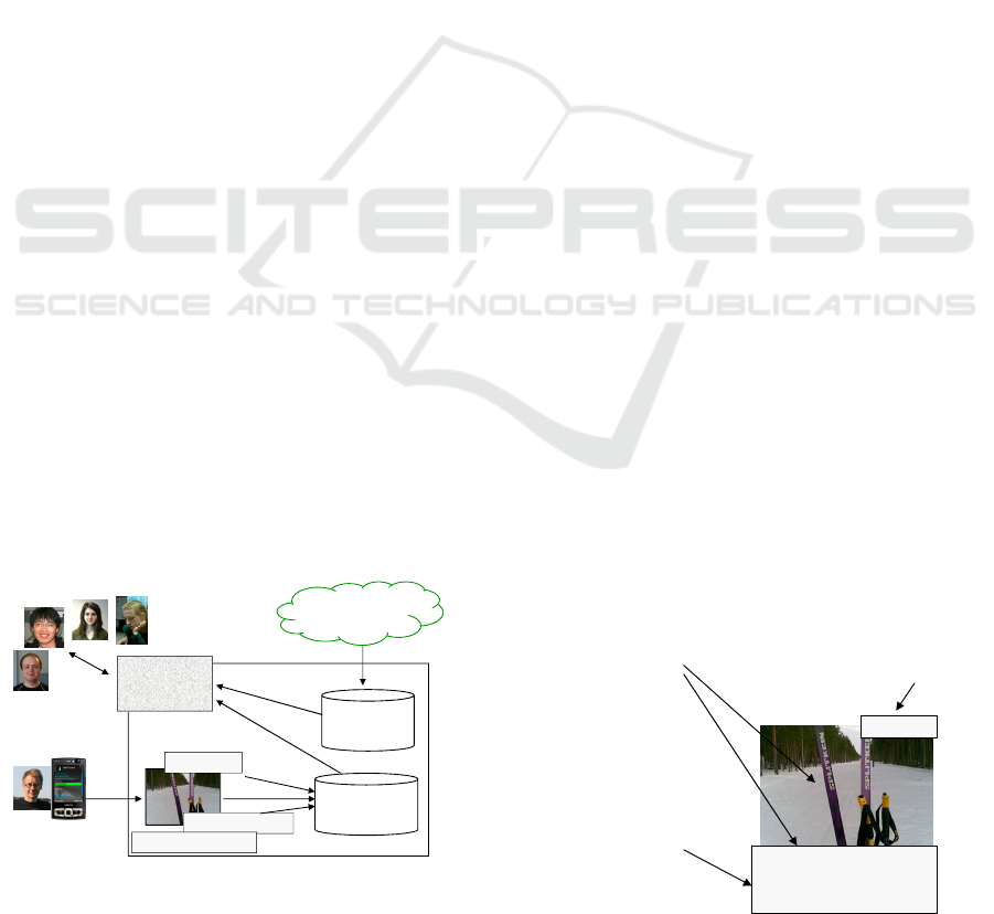
GPS
Data collector:
www
Other users:
MOPSI
webpage
Service
directory
N 62.63 E 29.86
User
collection
Last skiing of winter
User: Pasi
Figure 1: Diagram of the MOPSI data collection and
services. Available on-line: http://cs.joensuu.fi/mopsi/.
In this paper, we study mobile location-based
media sharing via internet by a case study based on
MOPSI service, which is prototype service for
sharing location-based media. The overall structure
of the system is outlined in Fig. 1 consisting of two
main parts: user collection and service directory.
The main limitation of this kind of ad hoc
information sharing is unawareness of the material
of others especially if the users are not directly
linked with each other. The data itself may be
available in the service but the problem is how to
find relevant data from service with a large number
of users. We argue that relevance can be defined by
the following aspects:
(1) Content of the data
(2) Location
(3) Time
(4) Author and his/her network
Last skiing of winter
Date: 4.4.2010
Location: N 62.63 E 29.86
Arppentie 5, Joensuu
User: Pasi
Keywords: skis, forest, snow
Informal description
Relevance defined by
the network of the user
Date and time
(not expected in July)
1. Content
2. Time
3. Location
4. Social network
Exact coordinates
Address for usability
Figure 2: Four aspects of relevance in practice.
These four aspects are demonstrated in Fig. 2 by
a concrete example where a person wanted to
capture the following scenario. From the photo and
its description we can see skis, forest and snow,
which relate to wintertime activity. The data also
reveals when and where the picture was taken. In 4
th
413
Fränti P., Chen J. and Tabarcea A..
FOUR ASPECTS OF RELEVANCE IN SHARING LOCATION-BASED MEDIA: CONTENT, TIME, LOCATION AND NETWORK.
DOI: 10.5220/0003342704130417
In Proceedings of the 7th International Conference on Web Information Systems and Technologies (WEBIST-2011), pages 413-417
ISBN: 978-989-8425-51-5
Copyright
c
2011 SCITEPRESS (Science and Technology Publications, Lda.)
April 2010, there was skiing tracks available, which
was not self-evident even for citizens of Joensuu.
Knowing a proper location was essential. The last
piece of information is the identity of the user
himself. Strangers may not benefit much of this
information but those who know him and share the
same hobbies are more likely to find this useful.
2 CONTENT, TIME AND
LOCATION
We discuss the three main aspects of MOPSI
system, of which location is an essential part. We
describe the system as its current state, and discuss
its design alternatives.
2.1 Content
Traditionally the relevance is defined by the content
either by user-given keywords, or using a predefined
format in database system, and then retrieved using
SQL queries. This requires well-designed static
database where the service provider models the user
behavior beforehand and provides information in
form of service directory.
In internet, well-defined attributes are not used
but relevant content can still be found from free text
using search engine if the content matches to the
keywords provided by the user. Tagging of the
photos can also be done afterwards, but usually free-
form textual explanation is simpler. It also serves the
purpose of social media.
In MOPSI, free-form text description is
supported instead of manual tagging. For browsing
the data on web, queries based on time, location and
content have been implemented. A simple
recommendation framework is also in MOPSI based
on user location and rating of the photos.
Further analysis of the relevance, content-based
image retrieval could be done based on color, texture
and shape features. Automatic image categorization,
aims at converting visual content into a set of
keywords to describe the content. In (Choudhury et
al., 2009, Yu et al., 2009) both visual content and
user tagging are jointly applied to recommend the
group, where a photo should best fit in.
2.2 Location
Exploiting the location of the user has become
popular due to wide availability of GPS positioning
in multimedia phones. In case of lacking GPS,
positioning can also be provided by cellular network
of mobile phone, or even using the IP address for a
rough estimation of location. Once the location is
known, it gives significant additional relevance that
can be utilized in several different ways. In MOPSI,
location is the key element and it provides additional
relevance in the following ways:
(1) Browsing data collection on a map
(2) Show location of other users
(3) Track the movements of the user
(4) Filter relevant search results for the service
directory
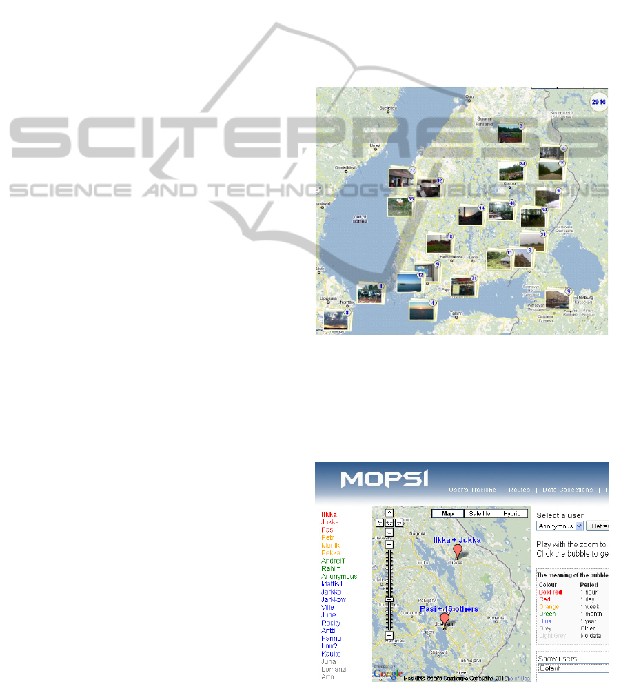
Fig. 3 demonstrates the map view in MOPSI
where photos have been clustered and then shown
using GoogleMaps API.
Figure 3: Map view of the data collection.
Location of users has been visualized in Fig. 4
using a so-called smart swap algorithm (Chen et al.,
2010) that provides accurate clustering in real-time.
For representing the clusters, approaches using
icons, grids, Voronoi diagrams, and coloring by the
Figure 4: Map view of user locations.
WEBIST 2011 - 7th International Conference on Web Information Systems and Technologies
414
density have been considered in (Delort, 2010). We
use a color bubble attached with the text
representing the most recent users in the cluster. The
browsing is supported by zooming operation to get
inside bigger clusters. Details of this solution will be
reported later elsewhere.
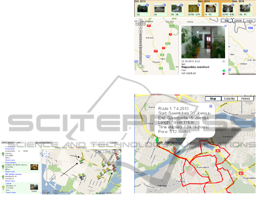
The collection can also be used as a part of
service directory in MOPSI either in mobile phone
or on web, see Fig. 5. Given location, user makes
query by keyword, but instead of providing relevant
search results by the content alone, results nearby
are given if they exist in a local database (green), or
found in the user collection (yellow).
Additional information (red) is provided by
location-based search (Fränti et al., 2010), which is
a combination of traditional location-based service
and search engine. Following the idea in (Huitema
and Fizzano, 2010), MOPSI allows user to transfer
search engine results (red) into the service directory
(green) by adding proper keywords similarly, and by
using photos from the user collection (yellow).
Database
Database
results
results
Search engine
Search engine
results
results
Results from
Results from
user collection
user collection
Figure 5: Web page interface to the service directory.
2.3 Time
Time can be added to the relevance of the data in
several ways. Firstly, the information may be
relevant only within certain time period. A concert
or a sport event happens in certain time and day, and
it is essential information for participants. In photo
collection, the information can also be relevant to
know when the photo was taken. In MOPSI
collection, we utilize this by providing time line
view to the data as shown in Fig. 6. Similar layout
was considered in (Setlur et al., 2009), with the
addition that also links to Wikipedia are supported to
provide more information besides just the photos.
Secondly, the time and location themselves can
be the essential data from an exercise session. For
example, the jogging track shown in Fig. 7 records
the length, duration and average speed. This is
typical book-keeping for a long distance runner in
his training. Although specialized GPS sport trackers
exist, the use of MOPSI service and mobile phone
allows automatic sending of the data into the server
Figure 6: Time-line view of the data collection.
Figure 7: Joint time and location for tracking sport
activity.
for user convenience. Moreover, photos can also be
taken from the same session by the same device, and
presented later jointly with the trajectory of the user
as proposed in (Petit et al., 2008).
In MOPSI collection, tracking user’s routes is
one of the main functions. The web interface
provides also navigation from the current location to
the location of the search result using GoogleMaps
API based on road maps. An interesting idea for
future consideration would be to use the route
collection of all users to offer better navigation for
pedestrians and hikers instead of the road network
more suitable for cars (Kasemsuppakorn et al.,
2009).
Third possibility to utilize the time information is
to consider the age of data. The newer the
information the more likely it is still valid as the life
expectancy of cafeterias, for example, in typical
metropolitan area are often measured in months
rather than in years. Moreover, information such as
weather condition is needed right here and right
FOUR ASPECTS OF RELEVANCE IN SHARING LOCATION-BASED MEDIA: CONTENT, TIME, LOCATION AND
NETWORK
415

now, so to speak. In Fig. 1, the skiing condition is
recorded for 4
th
April, but it hardly relevant for users
in July.
3 EXPERIMENTS
We next give overview of the data in the user
collection so far as on 25
th
October 2010. The
collection includes lots of test photos, and the
number of users is small, which may somewhat
skew the results. Nevertheless, some trends and
observations can be seen.
In total, there were 3589 photos of which most
are city views (839), then pictures of nature (801)
and other people (279). Few pictures are also taken
from events (90), documents (40) and animals (59).
In addition, there are photos that are counted as test
photos or failure pictures.
Another point of view is what kind of
descriptions has been typed in by the users. Due to
the experimental stage, a large amount of the photos
(27%) are without any description. The lack of
descriptions is also caused by the difficulty to type
by mobile phone, but descriptions can be added later
from the web interface.
Among the photos that have some kind of
description, significant amount of photos (35%)
have just garbage, some test word (Symbian_test), or
very generic object description (Mug, Wires, Mouse)
indicating test use. In total, 65% of all photos have a
meaningful description. Mostly documented
descriptions are travel photos of places (685), nature
(579), general objects (263), architecture (212)
people (210), and few general descriptions of events
and animals.
People are often described by their names, or by
their roles (runner, floorball player). Only few are
related to place (Untung / STMIK), age (Young
Andrei) or relationship to the person (my son Amir).
Events are significantly more often found in the
user description than could be concluded by content
analysis alone. In our case, events include mostly
work-related meetings described by their acronyms
(ecse, abi, mopsi meeting, ubiikki) but also running
competition (Åland half marathon) and actions
attached with feelings (quality time in skiing
elevator).
Another difference between content and user
description are travel photos. The location is not
easy to recognize from content but it could be
concluded from the positioning data. For example,
Clarke Quay, Geger beach, Suceava, Tahkovuori
and Aholansaari are locations whereas the following
descriptions include additional details: Petronas
Towers (building complex), Heureka (science
center), Singapore flier (Ferris wheel) and Olavin
linna (castle). The extreme case is Musta Pekka
mutkan takana (Black Pete behind the curve) where
Black Pete is the name of a particular slope in Tahko
skiing resort.
Table 1: Distribution of keywords (tags) used in Picasa
and Flickr, in comparison to the user descriptions of
MOPSI collection.
Description:
Picasa Flickr
MOPSI
All Real
Places --- 28% 21% 32%
Events and action 31% 17% 5% 7%
People 6% 7% 6% 10%
Objects --- 5% 8% 12%
Architecture and
nature
25% 21% 23% 37%
Animals --- 3% 2% 2%
Other 20% 16% --- 0%
Garbage 19% 2% 35% ---
Table 1 compares the textual description used in
MOPSI with two other photo sharing sites. The main
difference is that, in MOPSI, location is provided
automatically without any user interaction.
In Picasa, users provide the location by dragging
the photo on GoogleMap. Keywords and location
are thus provided explicitly as two different entities,
and consequently, users tend not to type any location
related keywords. Flickr has somewhat more
complicated interface based on Yahoo! Maps. Only a
predefined set of keywords are allowed, which
explains the quality of tags (only 2% garbage).
Despite the automatic positioning in MOPSI, it
does not reflect on the distribution of the type of
descriptions written. Unlike in Picasa, users still tend
to describe the location anyway for travel pictures,
probably because the position is not confirmed in the
device, but it happens hidden in the background.
Overall, the distribution of topics is rather similar to
that of Flickr. There are slightly more people and
objects described, but these could be just artifacts
from the system being at testing stage.
For photo collecting, two mobile applications
were developed (Java and Symbian C++). A large
number of failures were caused by the Java version,
which lacks several important features. Firstly, there
is an unavoidable delay from the click sound and
when the photo is actually taken. People tend to
move the camera right after they hear the sound and
before the actual picture will be taken. Secondly,
Auto-focus supported by Symbian helps a lot with
picture quality but it was not available in Java. Other
WEBIST 2011 - 7th International Conference on Web Information Systems and Technologies
416
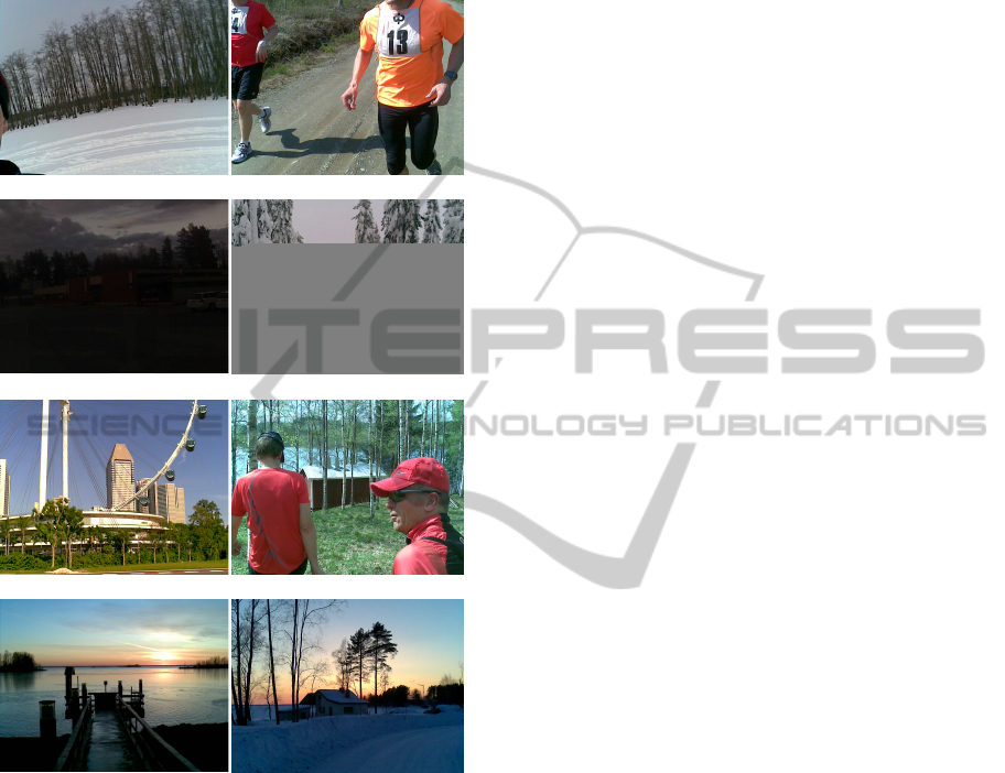
typical failures originate from low quality cameras
that do not work well in low illumination. Few
damaged pictures were caused by irrecoverable
transmission error. Samples are shown in Fig. 8.
Failure photo Still useful
Low illumination Broken transmission
Singapore flier (Going to) Sauna
No keywords needed No keywords needed
Figure 8: Photos of the first row are examples of software
problems (click sound), the second row of low
illumination and broken transmission problems. The rest
are successful photos.
4 CONCLUSIONS
We have presented a case study of MOPSI location-
based media collection and sharing service, and
studied how different aspects of relevance appear in
the system. So far the system has been used for
collecting user data (mainly photos and routes),
served as a test bench of new ideas, and a prototype
service directory. In all these, the location is a key
factor.
The media collection tool is also in professional
use by partnering companies for documenting
purpose, and can be used later for mobile location-
based games and an educational tool for teaching
principles of GIS, and other classes such as biology.
The fourth aspect of relevance, social network, will
be studied in future.
REFERENCES
Choudhury M. D., Sundaram H., Lin Y.-R., John A.,
Seligmann D.D., “Connecting content to community
in social media via image content, user tags and user
communication”, ICME 2009, 1238-1241, New York
City, July 2009.
Yu J., Joshi D., Luo J., “Connecting people in photo-
sharing sites by photo content and user annotations”,
ICME 2009, 1464-1467, New York City, July 2009.
Chen J., Zhao Q., and Fränti P., "Smart swap for more
efficient clustering", Int. Conf. Green Circuits and
Systems (ICGCS’10), Shanghai, China, June 2010.
Delort J.-Y., “Vizualizing large spatial datasets in
interactive maps”, IEEE Int. Conf. Advanced
Geographic Information Systems, Applications, and
Services, St. Maarten, Netherlands Antilles, 33-38,
Feb 2010.
Fränti P. , Tabarcea A., Kuittinen J., Hautamäki V.,
“Location-based search engine for multimedia
phones”, IEEE Int. Conf. on Multimedia & Expo
(ICME’10), Singapore, July 2010.
Huitema P. and Fizzano P., “A Crawler for Local Search”,
IEEE Int. Conf. Digital Society (ICDS), St. Maarten,
Netherlands Antilles, 86-91, Feb 2010.
Setlur V., Battestini A., Ding X., “Travel scrapbooks:
creating rich visual travel narratives”, ICME 2009,
1314-1317, New York City, July 2009.
Petit M., Claramunt C., Ray C. and Calvary G., “A design
process for the development of an interactive and
adaptive GIS”, W2GIS, 96-106, Shanghai, China 2008.
Kasemsuppakorn P., Karimi H.A., “Pedestrian network
data collection through location-based social
networks”, Collaborate COM, Crystal City,
Washington DC, Nov 2009.
FOUR ASPECTS OF RELEVANCE IN SHARING LOCATION-BASED MEDIA: CONTENT, TIME, LOCATION AND
NETWORK
417
