
AN INTEGRATED FRAMEWORK FOR THE
IMPLEMENTATION AND CONTINOUS IMPROVEMENT
OF THE ROMANIAN SPATIAL DATA INFRASTRUCTURE
Cristina Oana, Cristian Vasile and Lucian Zavate
Esri Romania SRL, Str. Roma 8, Bucharest, Romania
Keywords: Interoperability, Geoportal, SDI, Metadata, Standards, Discovery, Search, Web services, NSDI, Harvesting,
INSPIRE, Data sharing, Romania.
Abstract: This paper provides an overview of the first version of the Romanian NSDI GeoPortal. Geospatial data
availability, interoperability and integration remain is still a problem of the current spatial data
infrastructures (SDIs). The Romanian INIS GeoPortal, an ANCPI’s special IT project, has aimed to address
those challenges today. This online GeoPortal application enables easy, open, seamless, and on demand
discovery, access, retrieval, visualization and analysis of distributed geospatial data, information,
applications and web services from any member of the NSDI INIS Council. Challenges must still be
resolved, but a mature next release of the Romanian INIS GeoPortal will produce tremendous benefits for
the Romanian society and our National Spatial Data Infrastructure implementation.
1 INTRODUCTION
The Romanian INIS GeoPortal is designed to
facilitate the discovery and exchange geospatial data
resources to a broader community of users.
By the end of 2009, the National Center for
Geodesy, Cartography, Photogrammetry and
Remote Sensing completed a complex project which
is a major milestone of the NSDI building efforts
compliant with the INSPIRE Directive of the
European Union (2007/2/EC). These efforts
motivated us to develop the initial release of the
Romanian INIS GeoPortal by the National Agency
for Cadastre and Real Estate.
The associated growth in geospatial data
collection activities by the National Agency for
Cadastre and Real Estate and its subordinated
institutions and other government organizations has
a real potential and major benefits to improve
decision making process and operations at all
national levels through the Romanian INIS
GeoPortal application.
A centralized national metadata system and the
national geographic data system based on a uniform
reference data model and standards are provided via
the Romanian INIS GeoPortal application.
Web 2.0 era provides new principles and
technologies that facilitate information sharing and
collaboration and encourage user-generated content,
including bottom-up flow of information, open and
interoperable Web services, Web-oriented
architecture, mashups, geobrowsers, cloud
computing. All these technical advances are working
in favour of our National Spatial Data Infrastructure
(NSDI) implementation.
The feasibility and benefits of building the new
generation of our NSDI by expanding the use of the
Web 2.0 technologies are reflected also in our
initiative at the national level and demonstrated by
the success of the Romanian INIS GeoPortal
application.
The geospatial resources published in our online
Geoportal application are shared as open,
standardized and easy-to-consume Web services as
much as possible to facilitate being easily reused and
remixed via mashups, geobrowsers and other
applications.
The published Web services are made available
to other members of the NSDI INIS Council in
accordance to their access rights and to citizens
when appropriate, thus maximizing the value of the
existing geospatial resources.
With the Romanian INIS GeoPortal the search
time is reduced from days to seconds. As a broker
176
Oana C., Vasile C. and Zavate L..
AN INTEGRATED FRAMEWORK FOR THE IMPLEMENTATION AND CONTINOUS IMPROVEMENT OF THE ROMANIAN SPATIAL DATA INFRAS-
TRUCTURE .
DOI: 10.5220/0003549601760183
In Proceedings of the 13th International Conference on Enterprise Information Systems (ICEIS-2011), pages 176-183
ISBN: 978-989-8425-56-0
Copyright
c
2011 SCITEPRESS (Science and Technology Publications, Lda.)

between the INIS Council data providers and the
users, we do consider that our INIS GeoPortal
represents an important and highly visible
component of the National Spatial Data
Infrastructure, serving as the “face” of Romanian
Spatial Data Infrastructure.
2 INSPIRE DIRECTIVE AND
ACTIVITIES ON NSDI
DEVELOPMENT
2.1 Organizational Aspects
The National Agency for Cadastre and Real Estate
(ANCPI) is a state administrative organization
dealing with administrative and professional tasks
related to cadastre, geodesy, cartography, real estate,
remote sensing and spatial data infrastructure.
ANCPI is organized in Central Office, County
Offices of Cadastre and Real Estate and Local
Offices which are organized as decentralized public
services with headquarters in the municipality of
each county.
The National Center for Geodesy, Cartography,
Photogrammetry and Remote Sensing (CNGCFT) is
a public organization which is subordinated to
ANCPI. ANCPI represents Romania in
EuroGeographics organization as an active member
and developed the national datasets to support the
EuroBoundaryMap, EuroGlobalMap,
EuroRegionalMap and EuroDem projects.
During 2008-2010, the National Agency for
Cadastre and Real Estate was building the
ROManian POsitioning System (ROMPOS). The
national system is being built using the most
advanced GNSS technological solutions. ROMPOS
was launched on September 8
th
, 2008, and has
already been used by the professionals and other
commercial users from Romania.
The National Agency for Cadastre and Real
Estate was also one of the main initiators to support
SDI activities in Romania as part of the first
INSPIRE work group in 2005.
By the end of 2009, the National Center for
Geodesy, Cartography, Photogrammetry and
Remote Sensing (CNGCFT) completed a complex
project which is a major milestone of the NSDI
building efforts compliant with the INSPIRE.
CNGCFT’s efforts allowed ANCPI to define a
strategy and implement a centralized cartographic
and mapping production system which led to
establishing of Topographic Information System
(TOPRO5), at scale 1:5.000.
Through TOPRO5 project ANCPI standardized
the topographic datasets and has defined detailed
solutions of the national topographic information
system in domain of data models, metadata rules and
procedures, accuracy, ways of presentation,
topological rules and sharing methods.
2.2 National Legal Aspects
The "Law of Cadastre and Real Estate Publicity"
(Law no. 7/1996) represents an important law for the
NSDI implementation framework. It regulates the
activities in the domains of cadastre, geodesy and
cartography. ANCPI (former the National Office of
Cadastre, Geodesy and Cartography) was founded
by this law.
The ANCPI is a public institution which is
organized according to the Romanian Government
Decree No.1038/1996 and of its subsequent
modifications (Romanian Government Decree No.
98/1999). The ANCPI has been brought under the
Ministry of Interior and Public Administration on
July 1st, 2001. Before July 2001, the ANCPI was
linked to the Ministry of Agriculture. ANCPI’s role
in the central public administration is to organize,
manage and coordinate the cartography, geodesy,
photogrammetry, remote sensing and cadastre
activities at national level according to the legal
settlements in these domains.
Directive 2007/2/EC of the European Parliament
and of the Council of 14
th
March 2007 establishing
an Infrastructure for Spatial Information in the
European Community (INSPIRE) entered into force
on the 15
th
May 2007 and operated by the 27
Member States of the European Union. The
transposition into the Romanian legislation was
January 2010 and is published in the Romanian
Official Journal on January 29
th
, 2010–OG 04/2010.
In the context of INSPIRE, an open and
transparent process for the national stakeholder
participation has been set up. Stakeholders are part
of the INIS Council which is under the coordination
of ANCPI as a Legal Mandated Organization in
INSPIRE.
INIS Council includes 19 organizations which
are composed of Technical Working Groups experts
for developing the technical specifications for each
spatial theme in annexes that they are responsible for
– Table 1. ANCPI plays a central role in reviewing
and testing the draft implementing rules and in
assessing their potential impacts in respects to both
costs and benefits.
AN INTEGRATED FRAMEWORK FOR THE IMPLEMENTATION AND CONTINOUS IMPROVEMENT OF THE
ROMANIAN SPATIAL DATA INFRASTRUCTURE
177

Table 1: INIS Council roles-key data themes addressed by
INSPIRE.
Responsible public
authority
Annex no. Spatial data theme
Ministry of Interior and
Public Administration -
ANCPI
I.1 Coordinate reference
systems
I.2 Geographical grid
systems
I.4 Administrative units
I.5 Address
I.6 Cadastral parcels
II.3 Orthoimagery
III.2 Buildings
III.6 Utility and
governmental services
Ministry of
Environment and
Forests
I.8 Hydrography
I.9 Protected sites
II.2 Land cover
III.7 Environmental
facilities
III.8 Production and
industrial facilities
III.11 Area
management/restriction/regulati
ons zones and reporting units
III.13 Atmospheric
conditions
III.16 Sea regions
III.17 Bio-geographical
regions
III.18 Habitats and
biotopes
III.19 Species distribution
Ministry of National
Defence
I.3 Geographical names
II.1 Elevation
Ministry of Agriculture
and Rural Development
III.3 Soil
III.9 Agricultural and
aquaculture facilities
National Institute of
Statistics
III.1 Statistical units
III.10 Population distribution -
demography
Ministry of Regional
Development and
Tourism
III.4 Land use
III.12 Natural risk zones
Ministry of
Transportation and
Infrastructure
I.7 Transport networks
Ministry of Education,
Research, Youth and
Sports
II.4 Geology
Ministry of Health
III.5 Human health and safety
Ministry of Economy,
Trade and the Business
Environment
III.20 Energy resources
National Agency
for Mineral Resources
III.21 Mineral resources
2.3 Challenges
An important challenge is to maintain a high level of
commitment of all stakeholders and their experts to
contribute to the development of INIS. This is not
trivial and requires a notable amount of expertise,
money, time and commitments as resources to
ensure a more effective implementation.
ANCPI is nominated as a contact point with the
European Commission and is in the process to set up
an appropriate coordinating mechanism inside INIS
Council. The difficult financial climate of this period
makes it potentially more challenging to support
investments in new IT infrastructures, education and
training services.
At the local level many public sector
administrations still have limited or no knowledge of
INSPIRE Directive due to an insufficient
dissemination efforts. We will see their local and
regional involvement to be more directly involved
when the data themes INIS’s organizations are
responsible for, mainly in Annex I and II are
addressed by INSPIRE.
2.3.1 Technical Challenges
Very few people understand or use the complexity
of the technical documentation of the INSPIRE
architecture. Even in using the guidelines for the
creation of metadata files that are compliant both
with the INSPIRE Implementing Rules for
Metadata, as well as relevant European and
international standards for geographic information
represent a technical challenge at this moment.
The capacity to sustain the training process,
technical competencies, consistence of training
materials and translation into Romanian language
have to be build up immediately. ANCPI have been
significant efforts in respect to the IT infrastructures
and signed an Enterprise License Agreement with
ESRI for three years to sustain coordination of the
INIS Council activities.
Another challenge during the implementation of
the Romanian INIS GeoPortal is creating and
hosting geospatial Web services requires more GIS
servers. Hosting Web services and keeping them
available with high performance and scalability
twenty-four hours a day requires appropriate
infrastructure. ANCPI is still in discussion to partner
with other government agency to have them host the
data as Web services or to have its data aggregated
to the partner’s infrastructure via real-time data
replication services or periodic ETL (extract,
transform, and load) processes.
ICEIS 2011 - 13th International Conference on Enterprise Information Systems
178
3 ROMANIAN INIS GEOPORTAL
3.1 Generalities
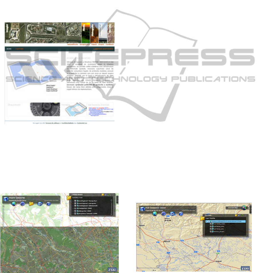
The Romanian INIS GeoPortal (Figure 1) developed
by ESRI Romania is designed to facilitate the
discovery and exchange geospatial data resources to
a broader community of users. By the end of 2009,
the National Center for Geodesy, Cartography,
Photogrammetry and Remote Sensing completed a
complex project which is a major milestone of the
NSDI building efforts compliant with the INSPIRE.
Figure 1: Romanian INIS GeoPortal home page.
The first version of the Romanian INIS
GeoPortal provides access to the following
resources: Romanian Base Map-TopRo5, at 1:5.000
scale, orthophotos at 1:5.000 scale, raster datasets
including scanned maps, topographic maps and
digital elevation models, network services and
applications (Figure 2).
Figure 2: Romanian INIS GeoPortal – first published
resources.
Geographic data available covers most of the
themes of the INSPIRE Annexes I and II.
Orthopotos at 1:5.000 scale has been used free by all
public and local authorities, Ministry of Agriculture
for the Land Parcel Information System and
Ministry of Environment as a decision support for
the Natura2000 and the following environmental
sectors: nature conservation, industrial pollution
control and risk management, air quality and noise,
waste management and water quality.
The Romanian INIS GeoPortal connect users to
other databases, services and geoportal applications
and serve as a catalyst for advancing Spatial Data
Infrastructure activities in Romania.
The associated growth in geospatial data
collection activities by the National Agency for
Cadastre and Real Estate and its subordinated
institutions and other government organizations
from INIS Council has a real potential to improve
decision making process and operations at all
national levels.
3.2 Major Components
The Romanian INIS GeoPortal has four major
components: a) web site, b) accessibility, c) content
management and d) administration.
The web site component provides the functional
capabilities to publish and search metadata and
visualize and directly connect to geospatial datasets
and services over a distributed network.
The second component – accessibility - gives the
ability to explore, query and use environmental
datasets and services through metadata catalogue,
metadata search functionality, search results process
and different map viewers.
Inside the Romanian INIS GeoPortal was
developed a customized map viewer presented
below in Figure 3, dedicated for the INIS Council
users.
Figure 3: Romanian INIS GeoPortal – customized map
viewer.
AN INTEGRATED FRAMEWORK FOR THE IMPLEMENTATION AND CONTINOUS IMPROVEMENT OF THE
ROMANIAN SPATIAL DATA INFRASTRUCTURE
179
Content management of the Romanian INIS
GeoPortal allows INIS Council users to participate
in using XML files and the last component consists
of the user account management and geospatial
administration component.
There are four different types of users with
different roles accommodated by the Romanian INIS
GeoPortal: anonymous, registered, publisher and
administrator. In order to get access to the specific
functionalities or to save searches and publish
metadata, the user should be registered through a
unique account based on username and password. If
the user would like to request publisher access to the
Romanian INIS GeoPortal, it should use the
Feedback link to contact the GeoPortal
Administration.
The main goal of the Romanian INIS GeoPortal
is to provide a powerful tool that allows INIS
Council’s users to publish, discover and browse for
GIS resources. The GIS resources that are identified
in the first version of the Romanian INIS GeoPortal
are:
Live Data and Maps - under this category are:
o ArcGIS Server Services: Geodata
Services; Mapping Services; Network
Services; Image Services; Geoprocessing
Services and Geometry Services;
o OGC Web Mapping Service;
Data Source - under this category are: OGC
Web Feature Service; OGC Web Coverage
Service; Downloadable data and Offline data;
Models and Tasks - under this category are:
ArcGIS Explorer Tasks; ArcGIS Toolbox and
OGC Web Processing Services;
Map Files - under this category are: ArcMap
Document; ArcGIS Explorer Document;
ArcMap Layer and OGC WebMap Context
Document;
Static Image Maps – under this category are:
Scanned maps and exported maps.
Figure 4: Romanian INIS GeoPortal published resources
available – Live data and maps.
3.3 Discovery Services
Searching through the INIS Geoportal's metadata
catalog is a quick way to find the data by the users.
If the users are registered in the Romanian
GeoPortal, it is possible to save their search criteria.
There are two search options available in the
Romanian INIS GeoPortal: a) basic and b)
advanced. The basic option (Figure 5) is accessed
directly from the GeoPortal home page and the
results will display in the search results page.
Figure 5: Romanian INIS Geoportal search type – basic
option.
The advanced search option provides more
search functionality - based on a text, spatial criteria
or combination of both criteria, enabling to define
more details for the user search.
Registered users in the Romanian INIS
GeoPortal have the option of saving the search
criteria so the search can be loaded again quickly in
the future by clicking the "My Saved Searches" link
and naming the search. Each returned record has
options associated with it.
The users could double click the metadata record
to expand its information section and see the
following options: Open, Preview, Website, Details,
Metadata, Zoom To and Thumbnails.
At the bottom of the search result page (Figure
6), there are six options: GEORSS, ATOM, HTML,
FRAGMENT, KML and JSON that enable users to
see their search results through the REST API.
ICEIS 2011 - 13th International Conference on Enterprise Information Systems
180
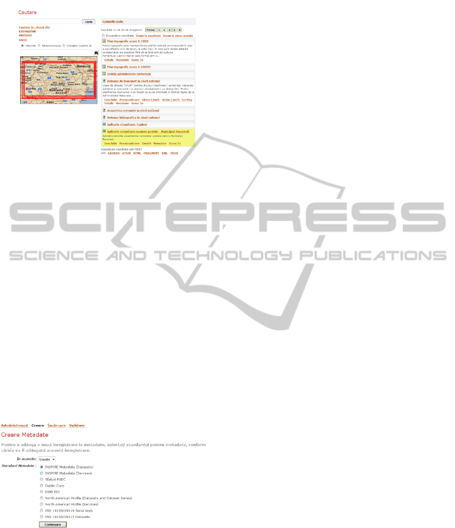
Figure 6: Romanian INIS GeoPortal search results – REST
API interface.
3.4 Metadata – Publish, Manage and
Access Rights
The success of the Romanian INIS GeoPortal
depends on the quality of metadata records it hosts.
The ISO standards – ISO 19115:2003 and ISO
19119:2005, respectively for metadata for datasets
and services are published and approved before it
can be discovered. Publishers can upload metadata
or create metadata to publish it to the Romanian
INIS GeoPortal.
At the moment of this published document, there
are approximately two hundred of metadata records
published. The validation is very important because
an invalid metadata will not be published. The
application schema for datasets and services used for
validation inside the Romanian INIS GeoPortal is
from ISO repository.
Figure 7: Romanian INIS GeoPortal – metadata.
Metadata is managed through the Administration
section in the Romanian INIS Geoportal. A
publisher user can only view and manage the records
he owns and the Geoportal administrator can view
and manage all the records uploaded by all
publishers and himself. Validation (Figure 9) is very
important because an invalid metadata will not be
published.
The Romanian INIS GeoPortal identifies the
standard and then use the record’s definition XML
file to determine what elements are mandatory. All
mandatory elements must be presented for the
document in order to be published to the Romanian
INIS GeoPortal.
Publishers registered to the Romanian INIS
GeoPortal designate what kinds of users see their
records in accordance to the access policy
configured by ANCPI and controlled at the record
level.
3.5 Data Download and
Transformation Services
The Romanian INIS GeoPortal allows the users to
download data from a published map service
through the Data Download interface.
This functionality is implemented by a tool
which allows the users to specify the layers of data
that want to be downloaded, the map projection of
the data, the output file format they want to receive
it, and the desired spatial extent.
The downloaded
data are emailed to the user in a zipped file.
Transformation services available in the
Romanian INIS GeoPortal during the first phase
allow users to: a) transform coordinates from one
coordinate system to another and b) to transform
data using Data Interoperability capabilities from
different data formats to another.
3.6 Testing INIS GeoPortal
The Romanian INIS GeoPortal was tested according
to test items and test cases described in the Test Plan
document. The test cases identification and design
has been designed to perform and analyse the
functional specifications and requirements, to
identify test items and to design test cases that
covered all test items.
The initial process of the Test Plan included
eleven test cases and several sub-test cases
consisting of:
Basic user interface-oriented functions in the
browser window;
Search metadata using specific criteria;
Retrieval of metadata search results;
Client map viewer functions;
Client map viewer interoperability;
Publish and retrieve metadata, as an
authenticated user;
User related information management;
AN INTEGRATED FRAMEWORK FOR THE IMPLEMENTATION AND CONTINOUS IMPROVEMENT OF THE
ROMANIAN SPATIAL DATA INFRASTRUCTURE
181

Metadata administration functions;
Browser compatibility;
Geoportal application server capabilities and
Standards compliance for data and metadata.
During the testing process of the Romanian INIS
GeoPortal application has occurred only one failure
related to the multiplicity of the metadata element,
as defined in the INSPIRE implementing rules and
ISO 19115/19119. This issue is planned to be solved
this summer when ANCPI is launching the next
release of the Romanian INIS GeoPortal.
3.7 GeoPortal Case Studies
In Romania, there are several developed geoportals
that can be classified by their usage, theme or
content format.
This section presents three different Romanian
Geoportal designs that can be categorized as
personal (Table 2), organizational (Table 3) and
national (Table 4) implementation, depending on
their usage. By theme, these three case studies of
geoportals have more specific orientations such as
biodiversity, environmental policies and general
subjects. By format, these geoportals range from
only Web services to other formats and
combinations of data and Web services.
Table 2: Personal geoportal - design considerations.
Usage Personal geoportal
Address http://www.geoportal-mediu.ro
Characteristics Convenience and seamless
integration with the proprietary tools
that biodiversity community use are
focused. National standards are less
important.
Metadata Comply with ISO 19115/19119
standards.
Publishing
method
Online form, XML upload, batch
publishing and harvesting are
available.
Administration Automatic.
Security Varies with specific requirements
related to three levels: custodian,
Ministry of Environment and public
users.
Discovery
method
Search or browse.
Result ranking Not important due to a small
numbers of records.
Performance
tuning
Not an issue with the small number
of habitats and species records.
Table 3: Organizational geoportal - design considerations.
Usage Personal geoportal
Address http://www.roenv-geoportal.ro
Characteristics National and international standards
(ISO metadata and OGC Web
services) are important.
Metadata Comply with ISO 19115/19119
standards.
Publishing
method
Online form, XML upload, batch
publishing and harvesting are
available.
Administration Manage accounts and metadata.
Security Varies with specific requirements
related to four levels: anonymous,
registered, publisher and
administrator.
Discovery
method
Search or browse.
Result ranking Important.
Performance
tuning
Very important when the size of the
metadata catalog is increasing for
each of the following environmental
sectors (nature conservation,
industrial pollution control and risk
management, air quality and noise,
waste management and water
quality).
Table 4: National geoportal - design considerations.
Usage Personal geoportal
Address http://geoportal.ancpi.ro
Characteristics National standards and INSPIRE
Directive (ISO and OGC
international standards) are very
important.
Metadata Comply with ISO 19115/19119
/19139 standards.
Publishing
method
Online form, XML upload, batch
publishing and harvesting are
available.
Administration Automatic.
Security Varies with specific requirements
related to four levels: anonymous
(public users), registered (44 INIS
Council), publisher (15 INIS
Council) and administrator.
Discovery
method
Search is critical and browse is also
available.
Result ranking Very important. A search result may
return hundreds or more matching
records available.
Performance
tuning
Very important when the catalog is
increasing.
ICEIS 2011 - 13th International Conference on Enterprise Information Systems
182

4 CONCLUSIONS
One of the most important benefits of the Romanian
INIS GeoPortal is GeoRNS (Geographic Resources
Naming System) which assign a unique
identification number for a published geospatial
resource. The GeoRNS web service is available via
SOAP and REST interfaces. This novelty of the
developed geoportal application allows us
versioning and easy tracking of the published
geospatial resources.
The second phase of the development of the
Romanian INIS GeoPortal will address the
following issues:
Sustainable efforts to complete the metadata
records describing all existing geospatial
information resources
Harmonization of key spatial data themes
across INIS Council to support environmental
policies
Agreements on network services and
technologies to discover, view, access and
download information resources
Policy agreements on data sharing and access,
including electronic licensing and eCommerce
to support whole processes online
Coordinating and monitoring Quality-of-
service mechanism at the national, local and
regional level
Availability of the advanced transformation
services
Advanced security and access control
The Romanian INIS GeoPortal implements a
framework that is standards-based, built on the
existing information technology standards and ISO
and OGC specifications and it is open/interoperable,
allowing choice of databases, hardware, networks,
GIS software and web browsers. It is scalable to
millions of users and creates horizontal and vertical
integration opportunities to discover and use of
geospatial data and web services.
Lessons learned from this application research
and new technologies in the future can improve the
quality of the geospatial Web services in support of
easy, fast, reliable, scalable and secure any
Geoportal application. This will serve to maximize
the return on geospatial investment for the
Romanian society as a whole.
The deployment of the Romanian INIS
GeoPortal will improve knowledge sharing, reduce
duplication of effort, direct people toward the best
available data, and improve the overall quality of
geospatial data and information of the National
Spatial Data Infrastructure.
ACKNOWLEDGEMENTS
The authors wish to acknowledge the contributions
and support from the National Agency for Cadastre
and Real Estate (ANCPI) and the National Center
for Geodesy, Cartography, Photogrammetry and
Remote Sensing (CNGCFT), in preparation of this
paper and the associated research.
REFERENCES
Vandenbroucke, D., Beusen, P., 2005. Spatial Data
Infrastructures in Romania: State of play Spring 2005.
Country report on SDI elaborated in the context of a
study commissioned by the EC in the framework of
the INSPIRE initiative. Retrieved from: http://
inspire.jrc.ec.europa.eu/index.cfm.
Vandenbroucke, D., Beusen, P., 2008. Spatial Data
Infrastructures in Romania: State of play 2007.
Country report on SDI elaborated in the context of a
study commissioned by the EC in the framework of
the INSPIRE initiative. Retrieved from: http://
inspire.jrc.ec.europa.eu/index.cfm.
Craglia, M., 2010. Building INSPIRE: The Spatial Data
Infrastructure for Europe, Retrieved February 25,
2011 from
http://www.esri.com/news/arcnews/spring10articles/b
uilding-inspire.html.
ESRI, 2010. ESRI Technology and Inspire, Retreived
February 25, 2011 from
http://www.esri.com/library/whitepapers/pdfs/esri-
technology-and-inspire.pdf.
Vasile, C., Oana, C., 2008. Presentation. The Romanian
geospatial portal builds a GIS foundation for the
nation, 3rd EC-GI & GIS Workshops, INSPIRE
Conference. Retrieved February 25, 2011 from
http://www.ec-
gis.org/Workshops/inspire_2008/presentations.cfm.
Loenen, B.v., Bessemer, J.W.J., and Zevenbergen, J.A.,
2009. SDI Convergence – Research, emerging trends
and critical assessment, Optima Graphic
Communication. Rotterdam.
Masser, I., 2007. Building European Spatial Data
Infrastructures, ESRI Press. Redlands.
Tang, W., and Selwood, J., 2005. Spatial Portals –
Gateways to Geographic Information, ESRI Press.
Redlands.
AN INTEGRATED FRAMEWORK FOR THE IMPLEMENTATION AND CONTINOUS IMPROVEMENT OF THE
ROMANIAN SPATIAL DATA INFRASTRUCTURE
183
