
GEOGRAPHIC INFORMATION SYSTEMS APPLIED TO
PATIENT DISTRIBUTION FOR FAMILY HEALTH TEAMS
IN PRIMARY HEALTH CARE
João Azevedo
1
, Carlos Oliveira
1
, Juliano Gaspar
1,2
and Alberto Freitas
1,2
1
CIDES – Department of Health Information and Decision Sciences, Porto, Portugal
2
CINTESIS – Center for Research in Health Technologies and Information Systems
Faculty of Medicine, University of Porto, Porto, Portugal
Keywords: Geographic information systems (GIS), Public health, Community health, Nursing, Family nursing, Primary
care physicians.
Abstract: Background: Family focused environment in Primary care is considered to be the future and help is required
to implement new conceptualities. One theory consists in dividing patients accordingly to geographic
clusters.
Aim: To study and implement methodologies for distribution of patients of a health unit, and develop a tool
to aid in this process.
Methods: A health unit was selected to recollect and process bio-geographic data of patients. A manual
division was executed and various methods were tested. An information system was developed in order to
help divide and compare between manual and automatic.
Results: The original data contained a significant percentage of errors (25%). This led to the cross validation
of addresses. This process took months. Only after, various patient division techniques could be applied.
One showed itself as having the most advantages. A robust GIS system was developed.
Discussion: The analysis took a significant amount of time. The method of dividing the patients proved
itself appropriate to this situation, and could probably be applied in many urban locations. The obtained GIS
provided time saving and better data comprehension.
Conclusion: Technologies in general and the system developed in particular can help patient allocation and
represent a breakthrough in time-saving.
1 BACKGROUND
1.1 Primary Health Care
Primary Health Care is a key element in any Health
System. It is in the front line, being the first contact
with the population. Health promotion, self-
empowerment and disease prevention are the pillars
to a successful Primary System (Atun, 2004).
Studies show, that in countries where an
emphasis is given to Primary Care, global health
costs are diminished (Atun, 2004). Home Care is
prioritized and Professionals are encouraged to have
a pro-active behavior and seek out the patient in his
home environment.
Recently, a new paradigm on health is trying to
be introduced, the methodology of allocate a
“Family Health Team” to every patient (MS, 2007).
It consists on a Physician and a Nurse. Also, one of
the main theories nowadays talks about clustering
patients in geographic areas, meaning, dividing
them accordingly to their home address. These
theories come, mainly, from the nursing area but are
extensible to both areas (OE, 2002); (MS, 2007);
(OE, 2007); (Joel and Stallknecht, 2000).
1.2 Geographic Information Systems
Geography takes a fundamental role in almost all
decision we made. A GIS can be defined by: “a
computer-based system for integrating and
analyzing spatially referenced data”(Cromley,
2003).
419
Azevedo J., Oliveira C., Gaspar J. and Freitas A..
GEOGRAPHIC INFORMATION SYSTEMS APPLIED TO PATIENT DISTRIBUTION FOR FAMILY HEALTH TEAMS IN PRIMARY HEALTH CARE.
DOI: 10.5220/0003791104190422
In Proceedings of the International Conference on Health Informatics (HEALTHINF-2012), pages 419-422
ISBN: 978-989-8425-88-1
Copyright
c
2012 SCITEPRESS (Science and Technology Publications, Lda.)

It is proven that the use of GIS in health care is
effective (Graves, 2008) and useful in discovering
new patterns and optimize existing resources.
As quoted by Dredger S: “if a picture is worth a
1000 words, then a map is worth 1000 pictures”
(Dredger et al., 2007).
1.3 Motivation
This study results from a request made by the
Clinical Council of “Agrupamento de Centros de
Saúde Porto Ocidental (ACES)” and the execution
of a master thesis in the same subject.
2 AIM
The aim of this study is to analyze and implement a
distribution of patients of a health unit, and to
develop a tool that can aid in this process. The
distribution should be calculated throw various
tested rules, using data from a health organization.
3 METHODS
This study followed this methodology: Select a
health unit; compile biographic and geographic
data; process it in order to filter errors; execute a
manual division of patient; test various methods to
divide; develop an information system; present the
results to the health unit; compare manual to
automatic division.
3.1 Family Health Unit Data
This study was made in Portugal, in the city of
Porto, in the western Health Center (Agrupamento
de Centros de Saúde Porto Ocidental”) in order to
help opening a new Family Health. For this unit, 5
lists of patients were needed because there were 5
Physicians and 5 Nurses. The data included 3
existing units as seen in table 1.
Table 1: Number of patients existing in original units.
Health Units
Existing
patients (n)
Unit X Unit Y Unit Z
5439 7252 2021
Mixing all 3 databases resulted in a total of 4714
patients. From these, only the patients that lived in
Porto city where selected n = 12848; after that a
new selection was made excluding all patients that
lived outside the Health Unit influence area. This
area comprehended 4 parishes within Porto city. .In
this area we get a total of 8421 patients (table 2).
Data was analyzed with the use of statistical
measures and cross validation with central post
databases of the country.
3.2 Distribution Criterions
The main methods that were used focused on
dividing the population having in consideration
their distance to the central location (the health
unit), the discrepancy between different lists, the
minimum weighing number of people to exist
within a list (1917 to 2412) and the real number of
existing people acceptable by professionals (1550 to
1800 - Division criterions are stated in table 2.
The division of patients was made by: Manual
Division; Matrix Grid division; Circular cluster
division; Concentric circles and Triangular
expansive out method.
Table 2: Existing patients in used database and their
weighting.
Age interval
Average
weight
n
Weighting
formula
Weighted
n
[0 to 6[ 1,5 347 n * 1,5 520,5
[6 to 65[ 1 6590 n 6590
[65 to 75[ 2 678 n * 2 1356
[>= 75] 2,5 806 n * 2,5 2015
Total 8421 10481,5
4 RESULTS
4.1 Data Analysis Results
The final selected amount of patients was as
showed in table 2. Patients were divided using the
criterions mentioned earlier.
Table 3: Number and percentage of errors found in
database.
Error description n %
Missing door number 511 6,07
Missing City 13 0,15
Missing street 25 0,30
Address incorrect (street name non
existing)
2137 25,38
HEALTHINF 2012 - International Conference on Health Informatics
420
Many errors were encountered within the
database as shown in Table 3. These had to be
addressed one by one in order to correctly input the
coordinate in the map. This validation took months.
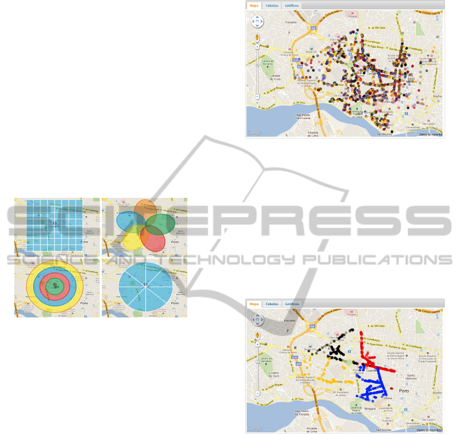
4.2 Patient Distribution Method
A variety of methods were used in order to divide
the 8421 patients between 5 different groups.
The most common method used by Health Units
is the manual one. Health professionals use printed
maps and clipboards in order to distribute people.
This method was used in order to primary divide
people and lasted 9 months. Another method tested
is systematized and implies a matrix division (grid
display) of lists (shown in 1
st
capture of figure 1).
Figure 1: Representation of patient division methods
used.
In Circular Cluster Division, circular clusters
were drawn not having the Health unit as center
(seen in 2
nd
capture of figure 1).
Using Concentric Circles, the unit was placed in
the center of the map and concentric circles are
drawn, from the inside to outside as seen in 3
rd
capture of figure 1. Finally we have the Triangular
Expansive out method, in which we place the
Health unit in the center and then lines are drawn
similar to a circle division in slices (shown in 4
th
capture of figure 1).
4.3 GeoPrimaryHealth
The system obtained is a GIS destined to Health. It
used HTML, CSS, Ajax, PHP and Javascript. The
server has Apache and MySQL database manager.
There is also use of Google Maps API 3.0.
Non-systematized division of the patients can be
seen in fig. 2. In figure 3 we can see a glimpse of
the patient distribution made using the method
earlier chosen.
Figure 2: System showing the initial patient distribution.
5 DISCUSSION
5.1 Data Errors
It is vital to centralize the raw data of all population
for health databases feeding. Addresses, phone
numbers, birthdates are a few of fields that have to
be validated and centralized in order to avoid
patient process duplication or misinformation.
Figure 3: Representation of patient division methods
used.
5.2 Division Method Chosen
The method that had the most benefits was the
triangular expansive out because: with this
distribution there’s always a non-significant
difference in terms of the distance between the
patients and the central unit. Due to the fact that
there’s no perfect geometric division in cities, the
method choose in the system was called: “Street
based semi-automatic triangular expansive out”.
5.3 Problems in the Division Process
One of the most important problems was the fact
GEOGRAPHIC INFORMATION SYSTEMS APPLIED TO PATIENT DISTRIBUTION FOR FAMILY HEALTH
TEAMS IN PRIMARY HEALTH CARE
421

that: if we really allocate cluster geographically,
what will we do with the following future
migrations within or without the major primary
cluster. It’s expected that families that today live in
one cluster may move to another or outside the
major one. Moving outside all clusters can be easily
addressed, but moving within different cluster can
be difficult.
Reality and legal environment shows that
moving people from one physician to another is
hard due to the lack of professionals. Also, in the
beginning we are geographically dividing clusters
of people in the assumption that it’s better for work
practice and for patient health. Changing the rules
in the future destroys all of the primary purposes.
Another very common problem can be the
constant cycle of in and out of health professionals
(hiring, retiring, etc.). If we make a geographical
cluster with all of its population, but in the same
area there are other patients that have different
Family Health Teams. In the beginning they’re not
considered to enter the cluster, but they actually live
within its area. If the Team of the second groups
moves away, a group of people emerges within an
already full formed cluster. What to do? Have they
not the same right as the other to belong in an
existing formed cluster? Does the team have to
enlarge its number limits and endanger healthcare
quality? Have we the right to destroy a full formed
and functional cluster? These are all questions
rather difficult to answer.
5.4 GeoPrimaryHealth Suitability
Taking in consideration that the manual method
used took 6 months and that with the help of the
system developed time spent was only hours, its’
suitability and advantage is significant. Of course,
this is only due to the fact that polluted data was no
longer present and a correct coordinate could be
extracted without a doubt from patient addresses.
This means that is still much to do in order to clean
databases and obtain a reliable source of
information.
6 CONCLUSIONS
After the completion of this work, we can conclude
that the system developed, can help patient
allocation and that represents a breakthrough in
time-saving. Doing this automatically after the
system is fully developed, took 1 hour in opposition
to months doing it manually.
6.1 Future Work
One of the future work that can be developed is to
follow the Health unit that adopted this distribution
of Patients in order to identify what changes
occurred. Finally, we can also distribute this system
between all Health Units that may need it in order
to verify if this method of distribute patients is
usable in other scenarios (small villages, rural
environments, islands, etc.).
ACKNOWLEDGEMENTS
To the “ACES Porto Ocidental” for requesting our
help and all the collaboration given. To the unit that
was created for all the help and patience.
REFERENCES
Atun, R. 2004. What Are The Advantages And
Disadvantages Of Restructuring A Health Care
System To Be More Focused On Primary Care
Services? Who Regional Office For Europe (Health
Evidence Network Report).
Cromley, E. K. 2003. Gis And Disease. Annu Rev Public
Health, 24, 7-24.
Dredger, S. M., Kothari, A., Morrison, J., Sawada, M.,
Crighton, E. J. & Graham, I. D. 2007. Using
Participatory Design To Develop (Public) Health
Decision Support Systems Through Gis. Int J Health
Geogr, 6, 53.
Graves, B. A. 2008. Integrative Literature Review: A
Review Of Literature Related To Geographical
Information Systems, Healthcare Access, And Health
Outcomes. Perspect Health Inf Manag, 5, 11.
Joel, L. & Stallknecht, H. 2000. A Global Connection.
The International Council Of Nurses Works To Unify
The Profession. Am J Nurs, 100, 109-11.
Ms, M. D. S. 2007. Decreto-Lei N.º 298/2007 De 22 De
Agosto. In: Saúde, M. D. (Ed.) 161. Diário Da
República.
Oe 2002. A Cada Família, O Seu Enfermeiro. In:
Enfermeiros, O. D. (Ed.).
Oe 2007. Sistema De Informação Em Enfermagem;
Princípios Básicos Da Arquitectura E Principais
Requisitos Técnico-Funcionais. In: Enfermeiros, O.
D. (Ed.).
HEALTHINF 2012 - International Conference on Health Informatics
422
