
NAVIGATION AND INTERACTION IN URBAN ENVIRONMENTS
USING WEBGL
Mar´ıa Dolores Robles-Ortega, Lidia Ortega, Francisco R. Feito and Manuel J. Gonz´alez
Department of Computer Science, University of Ja´en, Paraje Las Lagunillas, s/n 23071 Ja´en, Spain
Keywords:
WebGL, X3DOM, 3D Urban Scenes, X3D, Web System.
Abstract:
The process of rendering and interacting with large scenes in web systems is still an open problem in 3D urban
environments. In this paper we propose a prototype to visualize a city model in a client-server architecture
using open-source technologies like WebGL and X3DOM. Moreover, free navigation around the scene is
allowed and users are able to obtain additional information when interacting with buildings and street furniture.
To achieve this objective, a MySQL geodatabase has been designed to store both geometric and non-geometric
urban information. Therefore, the extra data about the urban elements is obtained through queries in the
database. The communication process between MySQL and the X3D model is performed by Ajax.
1 INTRODUCTION
3D City Modeling (3DCM) is a research area of great
interest with a wide range of applications such as ur-
ban planning, architecture, emergency management,
or engineering and construction. The accessibility
of these tools through the Internet would be a desir-
able option. However, there are some problems which
should be solved before achieving this objective.
One of the biggest challenges in this area is the
processing of large scenes. Thus, a city model is
usually a heavy data set to be transmitted in a client-
server architecture, especially when it has been gener-
ated using real data sources like Geographical Infor-
mation Systems (GISs). As a result, a simplification
process is needed in order to reduce the scene size and
to improve the performance. A LOD (Level of Detail)
technique could be used for this purpose or even an
occlusion culling method.
Another significant feature is providing free navi-
gation along the scene because unguided walkthrough
is the natural way that a pedestrian uses to move
around the scene. Nevertheless, due to the quantity
of information to manage, a free navigation system is
a complex process which should be carefully studied.
In addition, the real-time interaction with the
scene elements to obtain additional information is
an essential requirement in 3DCM. These extra data
could be stored in the scene itself or in a database.
The second option is more flexible because the infor-
mation can be changed without modifying the urban
model.
Evidently, the language used to implement the
system should fulfill all the requirements described
above. Nowadays there are some approaches, like the
ISO standard language X3D (W3C, 2004) for render-
ing 3D scenes in the Web, but they need the installa-
tion of specific plugins. To avoid this drawback, some
technologies like WebGL and X3DOM can be used.
These tools allow the visualization of 3D models in a
browser without any additional plugin.
WebGL is a new standard for accelerated 3D
graphics rendering in the Web that complementsother
technologies in the future HTML5 standard (Marrin,
2011). X3DOM is a new technology (Behr et al.,
2009) which allows the direct integration of the X3D
scene tree into the HTML5 DOM (Document Ob-
ject Model), and the direct renderization in the web
browser of an interactive, real time representation of
the scene in the HTML.
In this paper we propose a Web system for ur-
ban navigation and interaction implemented using
X3DOM and Ajax. We also define and create a geo-
database which stores both geometric and thematic
information about the scene elements. Furthermore,
users can move freely around this virtual environment
and obtain additional information when interacting
with the buildings and the rest of the scene elements
simply by clicking on them.
493
Dolores Robles-Ortega M., Ortega L., R. Feito F. and J. González M..
NAVIGATION AND INTERACTION IN URBAN ENVIRONMENTS USING WEBGL.
DOI: 10.5220/0003822804930496
In Proceedings of the International Conference on Computer Graphics Theory and Applications (GRAPP-2012), pages 493-496
ISBN: 978-989-8565-02-0
Copyright
c
2012 SCITEPRESS (Science and Technology Publications, Lda.)

2 CREATING THE APPLICATION
Next we describe the features incorporated to our web
prototype system for managing and visualizing urban
information. We explain the entities of the database
and the process for generating their associated X3D
files.
2.1 Description
Our system is able to store and manage 3D data not
only for visualization, but also for navigation and in-
teraction. We focus our approach on realistic visu-
alization, geometry minimization in order to be sup-
ported by a web-based system, free navigation around
the scene, and interaction with the buildings to obtain
additional information about them.
All the information stores in the database is ob-
tained from a 2D GIS. A java module using DAO
(Data Access Object) pattern has been used like in-
termediate tool between the 2D GIS and the database.
Another java function creates the X3D building mod-
els from the footprint geometry and its height, which
are obtained through queries in the database using the
JDBC driver. All the resulting X3D building files are
stored in the database in order to be reused for gener-
ating the global urban model, which will be render-
ized in the web page. Users will be able to move
freely around the scene and obtain additional build-
ing data like, for example, a brief description of the
establishment or the opening hours. The process for
obtaining this information is explained in Section 3.
Next we detail the geodatabase features.
2.2 Georeferenced Database
The database for our application should store both ge-
ometric and non-geometric information about the ur-
ban entities. Among the different options, MySQL
1
has been chosen because it is open-source and allows
full connectivity with PHP and other web technolo-
gies. Next we describe the most important tables in
the repository.
In the 2D GIS system used as input data, the
geometry of the buildings is stored as flat polygons
representing the footprint. This geometry is saved
afterwards in the database using the Polygon field.
The height is also stored and used to establish the
building height. With regards to the non-geometric
data, the available information is relative to the type
of services offered in the building, opening hours,
etc. Thanks to this table structure, both geometrical
and non-geometricalqueries are combined together to
1
http://www.mysql.com. Accessed October 2011.
Street_Furniture
Code
Description
URL_File
Position
Address
Street_Lamp
No. light bulbs
Type light bulbs
Age
Date last revision
Bus_Stop
Timetable
Bus routes
Another_Street_Furniture
Any additional attribute no
included in the
Street_Furniture table
Figure 1: Database schema of street furniture entities.
provide queries such as the nearest buildings from a
point or the eldest buildings of the city.
Street furniture is another important element in ur-
ban environments. However, there are many different
types of street furniture which are dealt such as Fig-
ure 1 shows. As can be observed, Street
Furniture ta-
ble includes the common features for all sort of street
furniture: an unique identification code, a brief de-
scription, the URL for the X3D file, a point which
represents the GPS position in the city, and the street
address. This design manages all those different char-
acteristics associated to each type of furniture and al-
lows that the database functionality can be easily ex-
tended. At the moment, three tables have been in-
cluded: Bus Stop, Street Lamp and Letter Box, but
any other could be added in the database.
2.3 Generating the X3D Scene
A manual modeling process of all the buildings in a
real urban environment is an impracticable task due to
the dimension of large cities. For this reason, we pro-
pose a method for automatic creation of X3D urban
models, which uses as input data the footprint poly-
gon and its associated height. Thus, the footprints be-
come 2.5D objects whose height is determined by the
value stored in the database. In particular, we have
implemented a Java module to create all the build-
ing faces in the X3D model using the IndexedFaceSet
node.
Nevertheless, the size of the resulting scene is still
very heavy and cause memory problems for being
renderized in a WebGL browser. Hence, an approach
to reduce the model complexity is needed. Tech-
niques like impostors (And´ujar et al., 2010), view-
dependent simplification(Chen et al., 2008) or level-
of-detail (LODs) (De Floriani et al., 2005) can be used
to achieve this objective.
In our application we manage level-of-detail since
GRAPP 2012 - International Conference on Computer Graphics Theory and Applications
494

X3D language directly supports this approach and we
want to evaluate their performance in X3DOM. The
LOD node allows that a single model could have mul-
tiple representations including high-resolution detail
(when users are close) and adequate lower-resolution
detail (when seen from a distance): LOD provides an
important capability for making overall performance
scalable when many scenes are composed together.
Specifically, the final scene has three levels of de-
tail: buildings, block of buildings and non-visible.
The first one is the most elaborated model, being ac-
cessible when users are located five hundred meters
away. If the distance is more than 500 hundred me-
ters and less than 1000, then the block of buildings
are visible. All buildings and blocks situated further
away are not renderized. Therefore, as only the geom-
etry of the nearest elements are loaded in the scene,
the memory usage is considerably reduced.
Once the procedurefor automatic modeling the ur-
ban geometry has been explained, next we describe
the interaction process with the buildings and the
street furniture.
3 INTERACTION WITH URBAN
ELEMENTS USING X3DOM
Integrating web 3D applications and geodatabases for
real time interaction is an important challenge in 3D
urban information systems. In this paper we propose
a prototype based on a client-server architecture in
which the client device visualizes and interacts in an
urban virtual world, while the server provides the ge-
ometric and thematic information. The application
has been implemented using open-source technolo-
gies like WebGL, X3DOM, MySQL and Ajax. Next
we describe the process for retrieving and visualizing
the scene information (urban geometry and street fur-
niture).
In our system, certain urban elements like build-
ings and street furniture are sensible to users’ inter-
action by generating a database query. For instance,
if a building is clicked, a window in the client side
is shown with a brief description in a straightforward
way. In the case of street furniture, some related infor-
mation is obtained, for instance the timetable of letter
boxes.
To implement this functionality, a function for
controlling events is needed. Unlike geometry, events
management in X3DOM is usually different from
X3D. For example, clicking event control in X3D re-
quires using a special type of node named touch sen-
sor. This node generates the clicking event, which
will be sent to other nodes via ROUTE statements.
Thus, the output field of a touch sensor can be con-
nected with the input field of another node (a script,
generally). In X3DOM touch sensors can be replaced
by the onclick HTML events.
The “click” action on sensible objects in the scene
generates a query in the geodatabase. However for se-
curity reasons, JavaScript functions are not allowed to
directly access to the database. To solve this problem,
we use Ajax technology and PHP code as an inter-
mediate mechanism to execute the queries. Ajax is a
group of technologies used on the client-side to create
interactive web applications. It can retrieve data from
the server asynchronously in the background, making
possible an increase in interactive or dynamic inter-
faces on web pages. In our application, Ajax retrieves
the additional information about the buildings or the
street furniture using PHP code.
Finally, when all the processes described above
are finished and the information is retrieved, the ap-
plication shows the results. For this purpose, we use
the JQuery library
2
, compatible with any browser.
4 RESULTS
Our prototype has been tested using Firefox and
Google Chrome browsers. In both cases users can
move freely around the 3D model of the city and ob-
tain additional information about certain urban urban
elements, as depicted in Figure 2. In this example, an
info window is shown on the client device screen af-
ter clicking on the window. This dialog includes the
opening hours of the shops located in the block.
As can be seen in Figures 3 and 4, we have ob-
tained a realistic city model in which both pedestrian
and flight navigation are allowed. All textures in the
scene are real photographs of the city of Ja´en. Thanks
to the use of LODs, the loading memory is reduced
because the geometry is in fact very simple and more
complex models are downloaded only when user is
close to them. Therefore, the time response and the
interaction with the scene is improved.
5 CONCLUSIONS AND FUTURE
WORK
In this paper we have described a prototype of a web-
based application to renderize an urban model using
open-source technologies like WebGL and X3DOM.
This achievement is obtained by creating a geo-
database which stores the main geometric and non-
2
http://jquery.com. Accessed October 2011.
NAVIGATION AND INTERACTION IN URBAN ENVIRONMENTS USING WEBGL
495
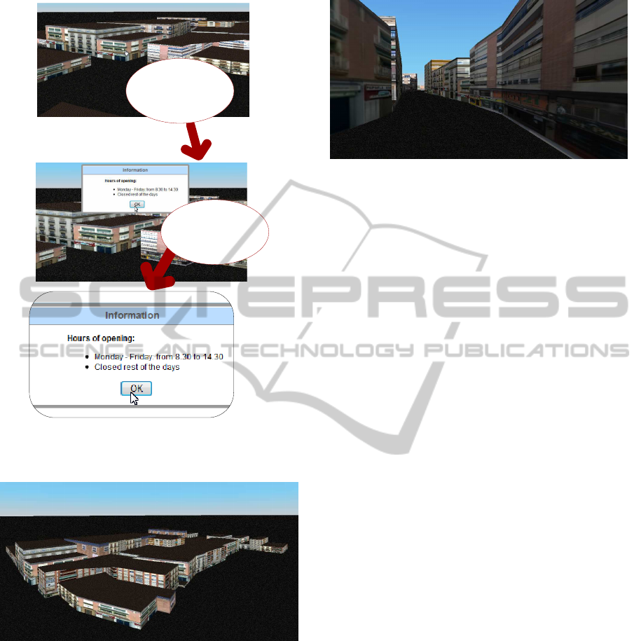
Some extra
information is
obtained
User clicks on a
building
Figure 2: Obtaining additional information about opening
hours.
Figure 3: Screenshot of the application.
geometric features about different city elements. Our
application is interactive because users can obtain ad-
ditional information about the entities in the scene
simply by clicking on them during the free navigation
process.
Our system can be used in many fields of appli-
cations such as tourist portals, engineering and con-
struction applications, etc. Furthermore, interaction
can be easily extended to any other entities simply by
modifying the database or adding touch sensors con-
trol in the 3D models.
We have used LODs nodes to reduce the loading
Figure 4: Screenshot of the application.
data in the client side and the response time. Thanks
to them, only the nearest nodes are renderized. In fu-
ture work an occlusion culling method could be used
to determine the exact visible set from a specific po-
sition.
ACKNOWLEDGEMENTS
This work has been partially supported by the Conse-
jer´ıa de Innovaci´on, Ciencia y Empresa of the Junta
de Andaluc´ıa and the European Union (via ERDF
funds) through the research project P07-TIC-02773,
by the Ministerio de Ciencia e Innovacin and the Eu-
ropean Union (via ERDF funds) through the research
project TIN2011-25259 and by the University of Ja´en
through the research project UJA2010/13/08 spon-
sored by Caja Rural de Ja´en.
REFERENCES
And´ujar, C., Brunet, P., Chica, A., and Navazo, I. (2010).
Visualization of large-scale urban models through
multi-level relief impostors. Computer Graphics Fo-
rum, 29(8):2456–2468.
Behr, J., Eschler, P., Jung, Y., and Z¨ollner, M. (2009).
X3dom: a dom-based html5/x3d integration model.
In Proceedings of the 14th International Conference
on 3D Web Technology, Web3D ’09, pages 127–135,
New York, NY, USA. ACM.
Chen, H., Zhan, S., Gao, Y., and Zhang, W. (2008). View-
dependent out-of-core rendering of large-scale virtual
environments with continuous hierarchical levels of
detail. In Computer Science and Information Tech-
nology, 2008. ICCSIT ’08. International Conference
on, pages 313 –321.
De Floriani, L., Kobbelt, L., and Puppo, E. (2005). A sur-
vey on data structures for level-of-detail models. In
Advances in multiresolution for geometric modelling,
Mathematics and visualization, pages 49–74.
Marrin, C. (2011). WebGL Specification. Khronos WebGL
Working Group.
W3C (2004). Iso/iec 19775:2004 - extensible 3d (x3d).
GRAPP 2012 - International Conference on Computer Graphics Theory and Applications
496
