
SATELLITE OBSERVATION OF BARE SOILS FOR THEIR
AVERAGE DIURNAL ALBEDO APPROXIMATION
Jerzy Cierniewski
Department of Soil Science and Remote Sensing of Soils, Institute of Physical Geography and Environmental Planning,
Adam Mickiewicz University, 61-680 Poznań, Poland
Keywords: Soil, Roughness, Albedo, Satellite Orbit.
Abstract: This study explores the diurnal variation in broadband blue-sky albedo (
α
) of soils with respect to their
roughness. Uncultivated soils and cultivated ones, after ploughing, harrowing and rolling were studied in
Israel and Poland. The relation between
α
of the surfaces and the solar zenith angle allowed to predict the
diurnal
α
variation of the surfaces located at a given latitude at any date, and calculate the optimal time T
O
related to their average diurnal albedo
α
observation. This procedure was used to assess the usefulness of
satellites on the sun-synchronous orbits for approximation of
α
for the moderately rough bare soil
surfaces, located between the latitude angles of 75° S to 75° N, within an error lower than ±2%. It was
found that the satellites on the orbits crossing the Equator at 10:30, such as the MODIS, and like the SPOT
and IRS IC, are not very useful for that, while the NOAA-15 on the orbit crossing the Equator at 7:30 is
much more useful. The best dates for the collection of data with this satellite are 16 April and 28 August,
while the worst date is June 22.
1 INTRODUCTION
The Earth’s surface shows variation in its reflected
radiation due to the direction of irradiating solar
energy and the direction along which the reflected
energy is viewed by ground, air-born and satellite
sensors. The reason for this variation is the
irregularities of the surface, which produce shadow
areas, where the solar beams do not directly reach all
surface areas. The radiation leaving shaded areas is
many orders-of-magnitude smaller than radiation
reflected from sunlit fragments. Reflectance of the
Earth’s surface is usually highest from the direction
which gives the lowest proportion of shaded
fragments. For example, bare soils with irregularities
caused by the soil texture, aggregates and micro-
relief configuration usually display a backscattering
reflectance peak towards the Sun, and decreasing
reflectance in the direction away from the peak
(Milton and Webb, 1987; Cierniewski et al., 2004).
Desert surfaces can have both a backscattering and
forward-scattering character (Shohsany, 1993). They
display maximum reflectance in the extreme
forwardscatter direction near horizon if they are
relatively smooth with a strong specular behaviour
(Coulson, 1966).
The bidirectional reflectance is defined as the
fraction of incident radiation that is reflected from a
surface along a given direction. Its value
corresponds to the precisely specific direction of the
surface illumination. Another physical quantity
describing a reflectance of a surface is the albedo. It
integrates the surface reflectance over all view
angles and is defined as the fraction of the incident
solar short-wave radiation (0.3-3μm) that is reflected
from a surface. The upwelling and downwelling
radiations are integrated over the whole hemisphere
(Schaepman-Strub et al., 2006). Martonchik et al.
(2000) recommend using the terms broadband
albedo or the narrowband (spectral) albedo if the
albedo characterizes the entire solar short-wave
spectrum or only a part of it, respectively. The blue-
sky albedo describes the albedo measured under
field conditions, where a surface is illuminated by
both direct solar irradiance and diffuse irradiance,
scattered by the atmosphere (Baret et al., 2005). In
many parts of the Earth, the reflectance of the land
surface changes seasonally. However, annual
variation of albedo is usually smaller than its daily
variation. The albedo, characterizing the intrinsic
properties of a surface, such as the surface
bidirectional reflectance, varies with solar zenith
229
Cierniewski J..
SATELLITE OBSERVATION OF BARE SOILS FOR THEIR AVERAGE DIURNAL ALBEDO APPROXIMATION.
DOI: 10.5220/0003903902290234
In Proceedings of the 1st International Conference on Sensor Networks (SENSORNETS-2012), pages 229-234
ISBN: 978-989-8565-01-3
Copyright
c
2012 SCITEPRESS (Science and Technology Publications, Lda.)

angle (Liang et al. 1999). Kondratyev (1969)
mentioned that, during the morning when the sun
elevation increased from 10°
to 60°, the albedo of
dry rocky and loamy soil surfaces decreased from
0.22 to 0.14 and from 0.34 to 0.21, respectively.
Pinty et al. (1989), Eckardt (1991), Lewis and
Barnsley (1994), Matthias et al. (2000) and Wang et
al. (2005) confirmed that the albedo of cultivated
and uncultivated desert surfaces varied significantly
at relatively high solar zenith angles.
Satellite radiometers are not able to measure
directly the broadband blue sky Earth’s surface
albedo. The anisotropic, non-Lambertian distribution
of the reradiation of soil and other Earth’s surfaces
must be inferred through a series of manipulations of
the raw remote sensing reflectance data (Maurer,
2002). Only the data representing cloud-free pixels
are analyzed. Since the satellite instruments measure
the radiance at the top of the atmosphere, and we
intend to estimate the albedo of the Earth’s surface,
a correction is required in order to account for the
effect of the intervening atmosphere. Because most
satellites collect the Earth’s surface data only at one
or a few directions inside their small field-of-view,
these data are recomputed with consideration of the
bidirectional reflectance of Earth objects. Lastly,
since satellites measure the Earth’s radiation in a
number of separate narrowband channels, an
extrapolation of the narrowband albedo values to
their broadband values is necessary.
The broadband albedo is used for modelling
environmental biophysical processes associated with
the energy transfer between soil, vegetation and
atmosphere, as well as for studying climate changes
at regional and global scales. Because the processes
are analyzed in the diurnal cycle, as well as over
wider time ranges, such as monthly, seasonal and
year-long, the average diurnal surface albedo seems
to be a helpful basis for the modelling. Sellers et al.
(1995) determined the accuracy requirement of
albedo for the global models as ±2%. It seems that
more attention should be focused on the time of the
satellite data acquisition because: i) the albedo
clearly vary during the day, ii) its value is required
with such a small error, and iii) the algorithms used
to convert the reflectance of a surface to its albedo,
relying on a semi-empirical approach (Olsen et al.,
2003, Zhou et al., 2003,Tsvetsinskaya et al., 2006),
are aimed at an effective elimination of the influence
of the non-equal distributed radiation from the
surface during a satellite passing.
This paper shows how the albedo of bare soil
varies as the solar zenith angle function depending
on their roughness. Examples of the broadband blue-
sky soil albedo sets were used, measured from the
ground level from midday to sunset. These relations
allowed to predict the albedo variation of bare soil
surfaces located at a chosen latitude during any day
of the year. The paper shows in which local solar
time the albedo of the moderately rough soil
surfaces located between the latitude angles of 75°
in
the Northern and Southern Hemispheres represents
its diurnal averaged value within an error lower than
±2%. We consider how it is possible to observe a
soil surface from satellites on sun-synchronous
orbits in the optimal time close to the moment when
its albedo reaches the average diurnal value with that
low error. The usefulness of a satellite placed on the
orbit close to that being optimal, as well as satellites
which most often have been used to the albedo
approximation, is analyzed here.
2 METHODS
The paper reports the relation between the
broadband blue-sky albedo
α
of soil surfaces in
Israeli Negev desert near Sede Boker (30° 51’26”N,
34°47’09”E) and the solar zenith angle
θ
s
. There, it
was possible to collect the data relating to the soils
developed from a loessial substrate with an
extremely high diversity of their roughness,
including extremely smooth uncultivated soil
surfaces, as well as moderate and very rough
cultivated surfaces after shallow and deep
ploughing, respectively (Fig. 1). These studies have
been continued in Poland on soil surfaces in the
western part of Poland near Poznań (52°34’57”N,
16°38’49.23”E; 52°28’48”N, 16°49’49.36”E). These
include cultivated soils (Luvisols according the
World Reference Base for Soil Resources),
developed from sands and sandy loams. Figure 1
shows three examples of such soils that were shaped
by ploughing, harrowing and rolling, respectively.
The α values of all surfaces were measured by an
albedometers LP PYRA 06 in a spectral range of
0.335–2,200 μm using data loggers. Shape of the
surfaces was controlled by a 3D laser scanner
Konica-Minolta VIVID-910. The texture and the
organic carbon content of the soil surface material
was controlled in the laboratory using a hydrometer
and Walkley Black’s method, respectively (Sparks et
al., 1996).
3 RESULTS AND DISCUSSION
This paper focuses on the most important results
SENSORNETS 2012 - International Conference on Sensor Networks
230
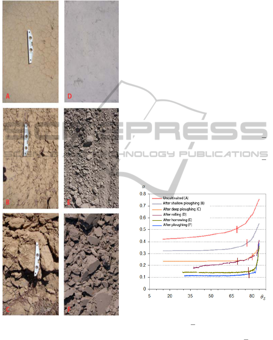
Figure 1: Soil surfaces tested in Israel (A-C) and Poland
(D-F).
obtained during tests carried out in Israel and
Poland.
The measurements of the albedo were carried out
in Israel on August 2008, and those in Poland from
May to September, 2011, under clear sky conditions
from solar local noon to sunset.
The relation between
α
and
θ
s
, derived from the
studies in Israel (Cierniewski et al., 2012) and
Poland clearly shows that
α
of a bare soil strongly
depends on its surface roughness (Fig. 2).
The
curves for the smooth surfaces (the uncultivated
surface and the cultivated ones after rolling) are
consistently higher than those of the very rough
surfaces (deeply ploughed). The curves related to the
extremely rough surfaces do not rise at
θ
s
angles
lower than 80°, while for the extremely smooth ones
they increase throughout the analyzed
θ
s
range,
rising strongly at
θ
s
higher than 75°. The shape of
the curves clearly affects the
θ
s
value at which the
α
reaches its average value.
The above relations, expressed by curvilinear
functions, were used to compute instantaneous
values of
α
for surfaces of a given roughness,
located at a chosen latitude during any day of the
year. They were also used to find the optimal time
T
O
relating to their average diurnal albedo
α
observation. The T
O
value was defined as the local
solar time when the
α
value, acquired by an
instantaneous observations best represents the
α
value for an given day (from almost sunrise to
sunset, i. e., when the
θ
s
does not exceed 85°).
Figure 2: Variation of the broadband blue-sky albedo (
α
)
of the studied surfaces as a function of the solar zenith
angle
θ
s
. Vertical red lines mark
θ
s
values that relate to the
average diurnal albedo
α
of the surfaces.
The semi-diurnal distributions of
α
and
α
of the
moderately rough soil surface (such as that tested in
Israel) are presented in Figure 3. The panels
represent selected days in the Northern hemisphere
(NH) to: the astronomical spring (21 March) and
autumn (23 September) equinoxes and the
SATELLITE OBSERVATION OF BARE SOILS FOR THEIR AVERAGE DIURNAL ALBEDO APPROXIMATION
231
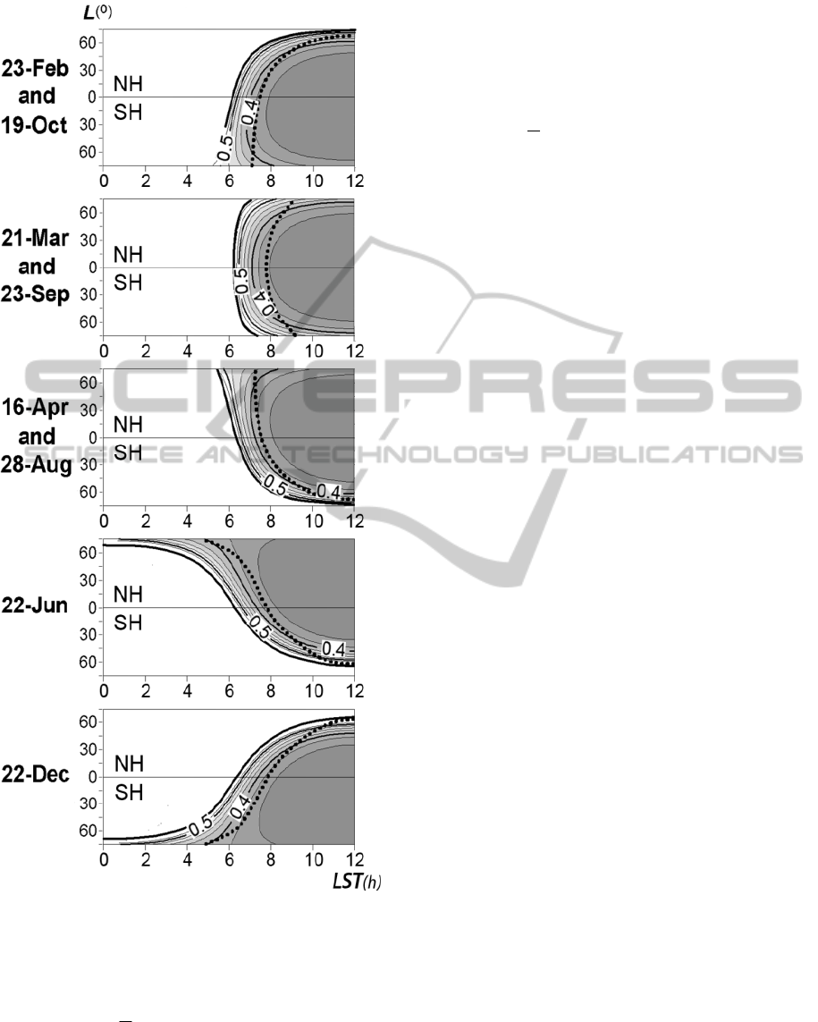
Figure 3: Morning semi-diurnal distributions of the
broadband blue-sky albedo
α
for the moderately rough
soil surfaces in the latitude (L) and local solar time (LST)
functions for the chosen dates. The bold isoline on the left-
hand side of the graphs shows extreme values of α for the
solar zenith angle
θ
S
= 85°, and bold dotted line - the
average diurnal
α
value for a given L. NH and SH
represent the Northern and Southern Hemispheres,
respectively.
beginning of the astronomical summer (22 June) and
winter (22 December), and additionally other days
that have a different pattern than mentioned above
(23 February, 16 April, 28 August and 19 October).
Each panel show contour lines (emphasized with
shading) of the
α
values as a function of the local
solar time and the latitude. The bold dotted line
shows the
α
values for a given latitude
(Cierniewski and Gdala, 2010).
Figure 4 gives the opportunity to observe the
moderately rough soil surfaces (as representing the
most common cultivated bare areas) at the time
close to the moment when their albedo viewed from
satellites on sun-synchronous orbits reaches the
average diurnal value with error lower than ±2%.
The following dates are chosen: 21 March, 16
April, 7 May and 22 June, using the examples of the
satellite NOAA-15 and MODIS, crossing the
Equator at 7:30 and 10:30 morning, respectively.
The orbit of the NOAA-15, as one of the few
civilian remote sensing satellites with the
descending node at so early local solar time, allows
to obtain these rough soil albedo data with the
acceptable error in limited ranges of the latitude. The
ranges are described by intersection points of the
two kinds of lines, describing limits of the
acceptable error ±2% of the data and the time of the
satellite passage. These latitude ranges are: 30°N-
50°S for 21 March, 75°N-15°S for 16 April, 60°N-
5°S for 7 May and 25°N-5°S for 22 June. The widest
range, larger than 90°, was found for the 16 April
(and correspondingly for 28 August) and the
narrowest one, 30°, for June 22.
The data obtained from the MODIS (like the
SPOT and the IRS IC), which have been often used
for the albedo approximation, can be much less
useful for this purpose. As Figure 4 shows, one can
obtain sufficiently precise results only in the very
narrow ranges of the latitude, not wider than 5°, and
moreover in the very high latitudes positions, higher
than 65°S for 16 April, 60°S for 7 May and 50°S for
22 June.
4 CONCLUDING REMARKS
The broadband blue-sky albedo
α
variation of a bare
soil as a function of the solar zenith angle
θ
s
clearly
depends on the soil surface roughness. The curves
describing this relation for the extremely rough
surfaces almost do not rise at
θ
s
angles lower than
80°, while the curves for the extremely smooth
surfaces increase throughout the analyzed
θ
s
ranges,
rising strongly at
θ
s
higher than 75°. The shape of
the curves clearly affects the
θ
s
value at which
SENSORNETS 2012 - International Conference on Sensor Networks
232
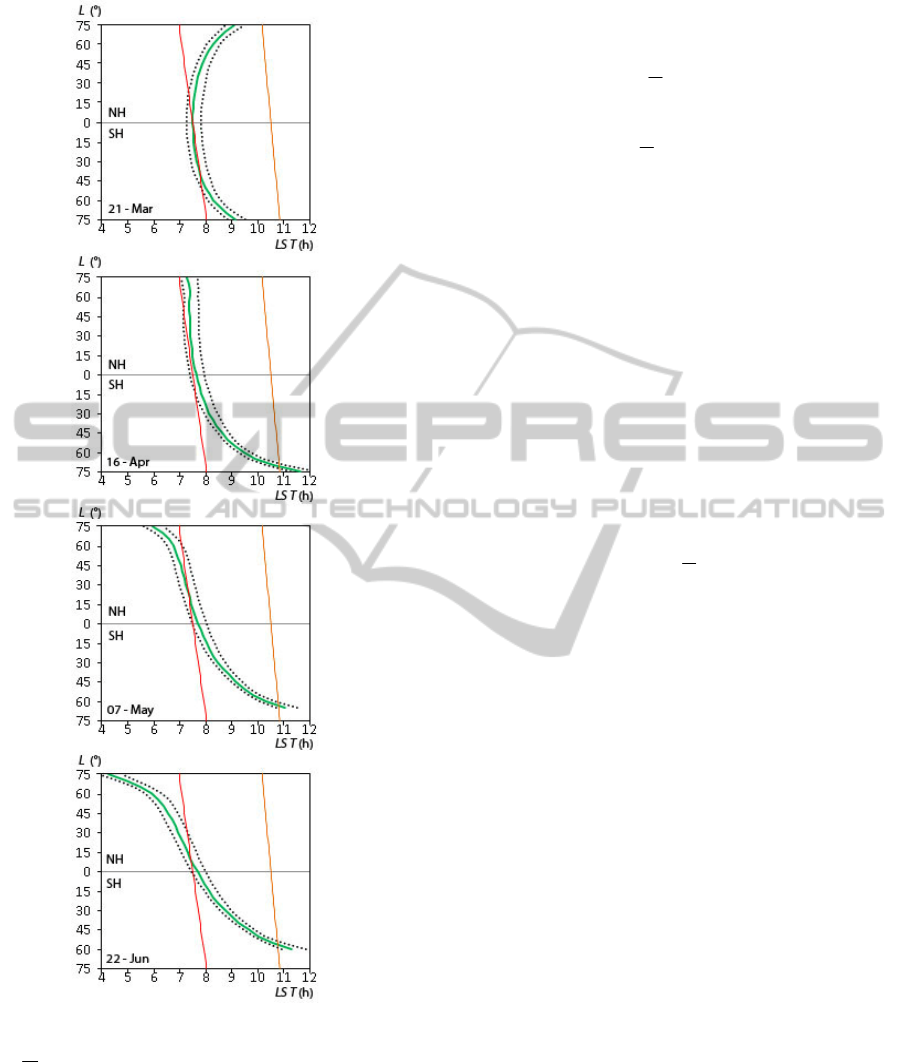
Figure 4: Time in the hour scale of local solar time (LST),
when the average diurnal albedo of the moderately rough
soil
α
(green line), predicted for the chosen dates varying
with the latitude (L), is available to be approximated with
the error lower than ±2% (dotted lines). The red and
orange lines depict the time the NOAA-15 and MODIS
passage. NH and SH represent the Northern and Southern
Hemispheres, respectively.
instantaneous
α
reaches its average value. The
relations between
α
and
θ
s
, expressed by curvilinear
functions, allow to predict the
α
variation of bare
soils located at a given latitude at any date, and
calculate the optimal time T
O
relating to their
average diurnal albedo
α
observation.
Such a procedure allowed to asses the usefulness
of satellites on the sun-synchronous orbits for
approximation the
α
of the most common
cultivated bare soil areas within an error lower than
±2%. The moderately rough soil surfaces, located
between the latitude angles of 75°
in the Northern
and Southern Hemispheres were chosen for this
assessment. It was found that the satellites on the
orbits crossing the Equator at 10:30, such as the
MODIS, and like the SPOT and IRS IC, are not very
useful for that, while the NOAA-15 on the orbit
crossing the Equator at 7:30 is much more useful.
Tho first group of the satellites is only useful for the
surfaces located in very high latitudes and not for all
dates. The latter satellite is useful within wide
latitude ranges in lower latitudes. The best dates for
the collection of data with this satellite are 16 April
and 28 August, while the worst date is June 22.
Approximation of the Earth’s surface albedo via
satellite data, collected closely to the time T
O
when
the soil surfaces reaches
α
value, will probably
result in a significantly reduced error in the
calculation of the albedo. The semi-empirical
approach, used to convert the soil reflectance to its
albedo, would be simpler. It would be only limited
to correction of the reflectance distribution relative
to a specific direction of a satellite viewing.
ACKNOWLEDGEMENTS
This work was supported by the Polish Ministry of
Science and Higher Education carried out under the
Project NN306600040. The author wishes to thank
Prof. Bajorski for the language revision of the
manuscript, as well as Dr. Cezary Kaźmierowski,
Dr. Sławomir Królewicz, Dr. Jan Piekarczyk,
Krzysztof Kuśnierek, MSc, and Michał Rymaniak,
MSc for their help in the measurements and
preparation of the figures.
REFERENCES
Baret, F., Schaaf, C., Morisette, J. and Privette, J. (2005).
Report on the Second International Workshop on
Albedo Product Validation. The Earth Observer, 17,
13–17.
Cierniewski, J., Gdala, T. and Karnieli, A. (2004). A
hemispherical-directional reflectance model as a tool
for understanding image distinctions between
SATELLITE OBSERVATION OF BARE SOILS FOR THEIR AVERAGE DIURNAL ALBEDO APPROXIMATION
233

cultivated and uncultivated bare surfaces. Remote
Sensing of Environment, 90, 505–523.
Cierniewski, J. and Gdala T. (2010). Calculating the
optimal time when albedo approximates its daily
average: an example using soil surfaces with various
roughnesses at different latitudes. International Jour-
nal of Remote Sensing, 31, 2697-2708.
Cierniewski, J., Karnieli, A., Kuśnierek, K. and Herrmann,
I. (2012) Approximation the average daily surface
albedo with respect to soil roughness and latitude.
International Journal of Remote Sensing (accepted for
publication).
Coulson, K. L. (1966). Effect of reflection properties of
natural surfaces in aerial reconnaissance. Applied
Optics, 5, 905-917.
Eckardt, M. (1991). Albedo changes and satellite
observations of the Earth. In Climate and Global
change – Proceedings of the European School of
Climatology and Natural Hazards Course, held in
Arles/Rhone, France, from 4 to 12 April 1990.
Brussels, Lxemburg: ECSC-EEC-EAEC, 123-137.
Kondratyev, K. Y. (1969). Radiacjonnyje Charakteristiki
Atmosfery i Zemnoy Poverkhnosti. Leningrad: Gidro-
meteorologicheskoye Izdatelstvo.
Lewis, P. and Barnsley, M. J. (1994). Influence of the sky
radiance distribution on various formulations of the
Earth surface albedo. In Proceedings Mesures
Physiques et Signatures en Teledetection, Val d’Isere,
France, 17–21 January, 1994, 707–716.
Liang G, S., Strahler, A. H. and Walthall, C. (1999).
Retrieval of land surface albedo from satellite
observations: a simulation study. Journal of Applied
Meteorology, 38, 712–725.
Martonchik, J. V., Brugge, C. J. and Strahler, A. (2000). A
review of reflectance nomenclature used in remote
sensing. Remote Sensing of Environment, 19, 9–20.
Matthias, A. D., Fimbres, A., Sano, E. E., Post, D. F.,
Aciolly, L., Batchily, A, K., and Ferreira, L. G.
(2000). Surface roughness effects on soil albedo, Soil
Science Society of America Journal, 64: 1035-1041.
Maurer J. (2002). Retrieval of surface albedo from space.
Retrived from: http://www2.hawaii.edu/~jmaurer/.
Milton, E. J. and Webb, J. P. (1987). Ground radiometry
and airborne multispectral survey of bare soils.
International Journal of Remote Sensing, 18, 3-14.
Olsen K. W., Bonan, G. B., Schaaf, C., Gao, F., Jin, Y.
and Strahler, A. (2003). Assessment of global climate
model land surface albedo using MODIS data.
Geophysical Research Letters, 30, 1443, doi: 10.1029/
2002GL016749.
Pinty, B., Verstratte, M. M. and Dickinson, R. E. (1989).
A physical model for predicting bidirectional
reflectance over bare soil. Remote Sensing of
Environment, 27, 273–288.
Schaepman-Strub, G., Schaepman, M. E., Painter, T. H.,
Dangel, S. and Martonchik, J. V. (2006). Reflectance
quantities in optical remote sensing – definitions and
case studies. Remote Sensing of Environment, 45, 15–
27.
Shoshany, M. (1993). Roughness-reflectance relationship
of bare desert terrain; An empirical study. Remote
Sensing of Environment, 103, 27–42.
Sellers, P. J., Meeson, B. W., Hall, F. G., Asrar, G.,
Murphy, R. E., Schiffer, R. A., Bretherton, F. P.,
Dickinson, R. E., Ellingson, R. G., Field, C. B.,
Hummerich, K. F., Justice, C. O., Melack, J. M.,
Roulet, N. T., Schimel, D. S. and Try, P. D. (1995).
Remote Sensing of the land-surface for studies of
global change: models-algorithms-experiments.
Remote Sensing of Environment, 51, 3-26.
Sparks, D. L., Page, A. L., Helmke, P. A., Loeppert, R. H.,
Soltanpour, P. N., Tabatabai, M. A., Johnston, C. T.
and Summer, M. E. (1996). Methods of Soil Analysis.
Part 3. Madison: Soil Science Society of America and
American Society of Agronomy.
Tsvetsinskaya, E. A., Schaaf, C.B., Gao, F., Strahler, A.
H. and Dickinson, R. E. (2006). Spatial and temporal
variability in moderate resolution imaging
spectroradiometer derived surface albedo over global
arid regions. Journal of Geophysical Research, 111,
D20106, doi:10.1029/2005JD006772.
Wang, Z., Barlage, M. and Zeng, X. (2005). The solar
zenith angle dependence of desert albedo. Geophysical
Research Letters, 32, doi: 10.1029/2004GL021835.
Zhou, L., Dickinson, R. E., Tian, Y., Zeng, X., Dai, Y.,
Yang, Z.-L., Schaaf, C. B., Gao, F., Jin, Y., Strahler,
A., Myeneni, R. B., Yin, H., Wu, W. and Shaikh, M.
(2003). Comparison of seasonal and spatial variations
of albedos from Moderate-Resolution Imaging
Spectroradiometer (MODIS) and Common Land
Model. Journal of Geophysical Research, 108, 15-1-
15-20.
SENSORNETS 2012 - International Conference on Sensor Networks
234
