
LOCATION INTELLIGENCE SERVICES FOR MOBILES USING
RUBY ON RAILS AND JQUERYMOBILE
Alfio Costanzo, Alberto Faro and Concetto Spampinato
Department of Electrical, Electronics and Computer Engineering, University of Catania, Catania, Italy
Keywords: Location Intelligence, Fuzzy Systems, Semantic Web, Location based Services, Mobile Computing.
Abstract: The current applications for mobiles provide information about Location Based Services (LBS) of user
interest that don't take into account the current status of the services neither they take into account the real
time conditions of the traffic network or of the weather. Aim of the paper is to show how location
intelligence services may be implemented by an open source solution that is able to help the activities and to
support the decisions of the mobile users taking advantage from all the information collected by the sensors
located on the field and from the business data stored on the disparate data stores that may be of interest of
the urban/metropolitan mobility, security and logistics. Fuzzy logic and semantic web technologies are
taken into account to improve the current LBS applications. A case study developed using Ruby on Rails
and JQueryMobile illustrates how such a web service may work in practice.
1 INTRODUCTION
The current applications for mobiles provide
information about Location Based Services (LBS) of
user interest that don't take into account the current
status of the services neither they take into account
the current conditions of the traffic network or of the
weather. Overcoming such limits is not easy since
this needs the availability of information outside the
control of the service providers, such as the travel
time to reach the destination depending on the
current traffic flows, the current availability of
parking vacancies and so on.
Also, the mobile applications don't support m-
commerce, i.e., commercial transactions carried out
on-line by mobile users. Implementing real time and
m-commerce services is only the first step to
activate advanced LBSs. In fact, it is also important
to provide the users with the information that best
fits their needs. For example, a cheaper park may be
suggested with lower priority if there is another park
that is more close to the destination in case of
raining. Another step is the one of integrating the
administrative Data Bases (DBs) resident on
separate computers relevant for LBS so that the user
may be informed on all the services potentially
available at the urban/metropolitan scale.
For this reason, the future mobile application
should be powered more and more by artificial
intelligence techniques, thus giving rise to location
intelligence services of practical user interest (Faro,
2011a). Although many intelligent mobile services
may be theoretically offered to the users, as the ones
proposed in the field of the intelligent transportation
systems (ITS) (McCubbin, 2003), they are rarely
offered in practice to the users. Often, the services
offered are not conceived to support the user
decisions or to optimize the user activities but to
provide the users with average information that give
a moderate help to their activities.
Moreover, ITS services are mainly distributed by
proprietary solutions that don't take advantage from
the information resident on the disparate DBs of
potential user interest. For example, sudden traffic
congestions or dangerous situations are not reported
to the interested users, service reservation cannot be
carried out on-line, neither the users are advised
when products of their interest are available on some
store.
Aim of the paper is to show how location
intelligence services may be implemented by an
open source solution that is able to help decisions
and activities of the mobile users taking advantage
from all the information collected in the data stores
that may be of interest of the urban/metropolitan
mobility.
In the paper we assume that the area is provided
with sensors that monitor in real time the traffic
763
Costanzo A., Faro A. and Spampinato C..
LOCATION INTELLIGENCE SERVICES FOR MOBILES USING RUBY ON RAILS AND JQUERYMOBILE.
DOI: 10.5220/0003940707630771
In Proceedings of the 8th International Conference on Web Information Systems and Technologies (WEBIST-2012), pages 763-771
ISBN: 978-989-8565-08-2
Copyright
c
2012 SCITEPRESS (Science and Technology Publications, Lda.)

conditions and the weather. Also, we assume that
business information about availability, vacancies
and cost of urban/metropolitan services are stored in
some server connected to internet.
Thus, the paper does not deal with the basic
monitoring technologies widely studied in the
literature, e.g., (Faro, 2008, 2011b)], but it is
specifically devoted to illustrate how to integrate all
the relevant information available on the net to
support the main use cases of the mobile users
depending on their current position. Fuzzy logic
rules and metadata technologies are used to help the
user mobility and her/his mobile business activities.
The Ruby on Rails (RoR) (Hartl, 2011)
framework is adopted to develop the web service
since it allows the designer to organize the
application as a collection of use cases that can be
reused for similar tasks (Faro, 1998, 2033a).
Moreover, RoR is provided with a powerful
language, i.e., Ruby, that facilitates the
implementation of: a) the fuzzy rules that address
user mobility and aid their decisions, and b) the
procedures to access the metadata layer that
integrate the disparate DBs. Other two languages
may be also used in RoR to facilitate the
implementation of LBS applications: a) Java scripts
to exchange with mobiles information geo-
referenced on Google Maps, and b) JQueryMobile
(Bai, 2011) to convey such information in a user
friendly format that may be visualized, without any
modification, on PCs, tablets and mobiles.
Section 2 shows how simple fuzzy logic and
Horn Logic rules may be implemented by Javascript
and JQueryMobile to improve the location based
services. Section 3 discusses how the use of
JQueryMobile and Javascript allow us to use the
metadata technology to favour the integration of the
proprietary DBs of interest of mobile users. The
advantages of implementing the Location
Intelligence services by using RoR and JQuery
Mobile will be discussed in section 4 by a small case
study dealing with a prototypical web application,
called WiCity, currently under test at our University,
that illustrates how an user can connect her/his
mobile to an RoR server to be informed by a suitable
interface, developed by JQueryMobile, on some
basic LBSs concerning mobility (parks, gas stations
and traffic congestions), health services (pharmacies
and first aid services), events/places of tourist
interest, and on the routes to reach by car the chosen
destination from the current user position by taking
into account the current traffic flows and weather
conditions. When discussing this prototype we will
outline how the methodological issues pointed out in
the previous sections may be used to implement
effective location intelligence services for citizens
and tourists.
2 IMPROVING LBS BY FUZZY
AND HORN CLAUSES
Location based services may be considered as a sort
of generalization of the Intelligent Transportation
Systems. The latter are mainly dedicated to improve
mobility and logistics activities of the mobile users,
the former aim at supporting such activities taking
into account also security, commerce and business
requisites. Thus, in LBS environment it is important
to reach the destination in the minimum time, but
also to avoid accidents or congested areas.
Analogously, the user may decide to follow some
non minimal path to reach the destination if this is
done in more safe conditions depending on the
weather conditions. As well as, the user may be
interested in paying the parks depending on the real
parking time rather than paying in advance basing
on some forecast of this time.
Although the rules that support such LBS
requirements are very simple, the current LBS
applications are mainly conceived as information
systems that provide the users with general
information while they are walking or driving. Thus,
in the following we will show how the LBS
effectiveness may be improved by using suitable
fuzzy logic rules (Wang, 2001) and Horn clauses
expressed in Prolog (Wielemaker, 2009).
2.1 Nearest Services and Safe Walking
To help the users to choose the most suitable nearest
services we should return to them a Google Map on
her/his mobile that shows the current user position
and two circles, one, let say C
w
, with a radius of few
hundreds of meters and the second, let say C
c
, with a
radius of about one kilometre, containing the
markers of the services located in such areas. The
former circle should point out the services that are
reachable by walking, whereas the second should
point out the ones reachable by car.
In principle, one can define the circle radius
following a very simple rule, i.e., the services
located in the smaller circle are recommended to the
walking people if the distance dist from the current
user position is such that dist < 300 meters. This
constraint would become dist < 1000 meters if the
user is driving a car.
WEBIST2012-8thInternationalConferenceonWebInformationSystemsandTechnologies
764
However, if there are no services available
within such circles, the user might accept a
moderately greater distance to find services of
interest. Of course, an arbitrary modification of such
distance is not acceptable, whereas it is fair to
inform the user on how much a certain increase of
the circle radius may causes a corresponding
decrease of her/his satisfaction of the solution
provided.
The computation of the radius corresponding to
the user expectations is straightforward in the fuzzy
logic framework in case we have to consider only
one condition that may influence the notion of
nearest. Indeed, for example, assuming that the rule
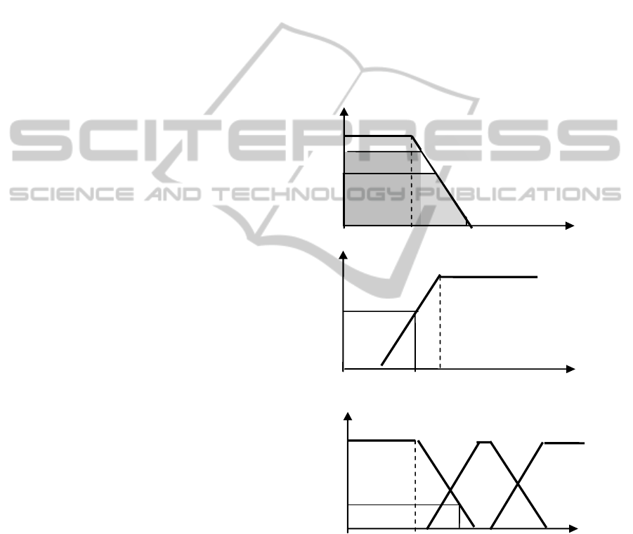
is "if the user is not young, then the user would like
to have the required service very close", and that the
user is 28 years old, from the fuzzy sets in fig.1c we
have that the evidence that she/he is not young is
given by the membership not [μ
young
(28 years old)],
i.e., 0.8, and consequently the most suitable radius is
the x-coordinate of the barycentre of the area M1 in
fig.1a, i.e., 175 meters.
The computation of the best radius d is a few
more complicated if we wish to take into account
more conditions together, plus the current user
position. In fact, the RoR application should be
provided with the fuzzy set of each condition and
with an algorithm to combine the radii derived from
the various conditions. To show how this can be
done, let us assume that our rule is: "if the user is not
young and it is cloudy, then the user would like to
have the required service very close". In this case, if
the people is 28 years and the sky is partially cloudy
(e.g., cloudiness degree = 0.4), we may derive the
maximum distance as the x-coordinate of the
barycentre of the two masses M1 and M2 in fig.1a.
The former represents the distance to be suggested
considering only the age, the latter refers only to the
cloudiness. Approximately it is 190 mt. Of course, if
the and contained in the rule is substituted by or, the
radius decreases since it is the x-coordinate of the
barycentre of the mass M1 or M2 that has the greater
membership, i.e., about 175 mt.
Thus, to solve the above problem, the RoR
application should know the current time and
weekday, as well as the user age and health status,
and the traffic and weather conditions measured by
dedicated sensing infrastructures.
How to measure the travel times for each street
has been widely analyzed by the authors in other
papers, whereas, in the case study, we will show
how the current weather conditions may be obtained
by connecting the RoR web application to Yahoo.
For what concerns the walking time to
destination we may assume that it depends on the
distance between the current user position and the
destination as suggested by Google Maps. But, in
case there are dangerous areas to avoid, the RoR
web application should inform the users about
alternative paths to reach either the destination or
safer locations. However, indicating alternative
paths using Google Maps is not a trivial job since
the routes suggested by Google Maps are based on
average conditions that cannot be modified easily by
the programmer. A solution of this problem is the
one of displaying the alternative pedestrian routes
like the minimum time driving routes using Google
Maps but in the more elaborated way discussed in
the next section.
NEAREST
500
300
μ
N
1
=
N
2
=
CLOUDY
C
1
C
2
YOUNG
30
20
40
60
MIDDLE
AGED
ELDERL
Y
μ
μ
0.6
0.2
cloudiness
degree
28
M1
08
0.6
M2
0.4
Figure 1: Fuzzy sets associated with the words: nearest,
young, middle aged, elderly, and cloudiness, where μ [0,1]
is the membership degree to such words of the values of
the definition domain, e.g., μ
young
(28 years old) = 0.2.
2.2 Safe and Fast Driving in the Traffic
The computation of the minimal route connecting
two intersections is certainly instrumental to find the
best route between two addresses. It may be
age (years)
distance d from the
user position (meters)
LOCATIONINTELLIGENCESERVICESFORMOBILESUSINGRUBYONRAILSANDJQUERYMOBILE
765

obtained by any program that is able to find the best
path connecting two points of a graph (Kumari,
2010). In (Faro, 2011a) we have suggested a
Mobility Based Prolog (MBP) Program, since it may
be used with little modifications to find also other
routes of interest of the user as the ones to find the
service that are nearest to the destination.
Also, this MBP program shows very satisfactory
time performance and allows us to update the travel
time of a street between two adjacent intersections x,
y from to t
1
to t
2
by simply retracting the fact
travel_time (x, y, t
1
) and asserting the new fact
travel_time(x, y, t
2
) in the Prolog knowledge base. In
this way, any accident or congestion or work in
progress involving a street may be immediately
taken into account by the program.
Another advantage of using Prolog is that a
simple generalization of the MBP program allows us
to solve the most relevant logistics problem, i.e., the
one to compute the minimal Hamiltonian cycle of
the graph associated to the traffic net, i.e. the cycle
that starting from an address will come back to the
initial address in a minimum time by traversing a set
of prefixed intermediate points.
Moreover, the previous fuzzy rules may be easily
written in Prolog, thus making possible that the
MBP program uses the membership values to
express if the routes or the mentioned Hamiltonian
cycles found are very (enough/few) fast
(fluent/slow). As a consequence, if the user is
interested only to fast routes to destination, the
program may suggest the route only if μ
fast
(T
route
) >
0.8, otherwise the user is invited to postpone her/his
travel.
2.3 Displaying the Best Routes
A suitable graphical interface that is compatible with
the one used frequently by the user is very important
for the usability of the web service (Giordano,
2002). For this reason we aim at informing the user
on the best path to destination or on the best cycle to
distribute or collect goods, by representing the
traffic network as a graph superimposed to the
Google Maps in such a way that its arcs coincide
with the streets and the nodes with the street
intersections.
Thus, after having identified the triples
travel_time (x, y, t) for every adjacent intersection
pair and having found the best route by using he
mentioned MBP program we should draw on Google
Maps the best path from a source intersection S to
the destination intersection D by the subsequent
drawing of linear traits connecting the adjacent
nodes traversed during the path. However, the lines
of such drawing don't correspond necessarily to
those of Google Maps since the links between nodes
are not always linear segments, neither we have a
database containing the adjacent nodes with their
geographical coordinates. Thus, we have two
problems: a) to find the geo-coordinates of all the
intersections, and b) to draw the links between
adjacent nodes like the ones of Goole Maps.
To solve the first problem it would be enough to
use the function "x AT y" that gives the coordinates
of the intersection between the road x and y. But,
this function is available for US, and not for all the
countries. Thus, our first problem is to find an
alternative way to compute all the intersection geo-
coordinates in the urban/metropolitan area.
Fortunately, this can be accomplished as follows: a)
pass to the API Directions of Google Maps the
names of the pair of streets (x, y) that have an
intersection to find the route that allows us to reach
by walking the initial address of x from the last
address of y (or in some case the initial address of x
to the initial address of y), and b) extract the
geographical coordinates of the first marker that
contains in its info window the name of the route y,
thus finding the geo-coordinates of the intersection.
However, as pointed out above, the knowledge
of the intersections together with their
geo/coordinates is not enough to find the optimal
route from any source address ad
s
to any destination
address ad
d
. Indeed, to solve the problem we have to
execute the following further tasks:
• to find the adjacent intersections. This can be
obtained by using the API Directions by verifying
for each pair of intersections if they are connected
by one step link, and
• to compute for any address ad
r
the set AD
out
(ad
s
)
of intersections that can be reached in one step from
ad
s
and the set AD
in
(ad
d
) of intersections that allow
us to reach in one step ad
d
. These sets can be
computed by using Directions to find the
intersections around ad
s
that can be reached
by
driving in one step from ad
s
,
and the intersections
around ad
d
that can be reached
by walking in one
step from ad
d
. Of course, we have to exclude in the
latter case the routes not allowed to drivers.
Finally, we have to compute, e.g., by using the
mentioned MBP program, all the routes connecting
any intersection in AD
out
to any intersection in AD
in
.
The best route is the one that is obtained by
minimizing, for any intersection belonging to AD
out
(ad
s
) and to AD
in
(ad
d
), the travel time T consisting
of the following three terms:
WEBIST2012-8thInternationalConferenceonWebInformationSystemsandTechnologies
766
T = t(ad
s
, AD
out
(ad
s
) ) + t(AD
out
(ad
s
) , AD
in
(ad
d
) )) + t(AD
in
(ad
d
), ad
d
)
(1)
To draw the same intersection links that will be
drawn by Google Maps, we use again Directions to
draw the connections between the adjacent
intersections of the best route by simply requiring
that such route is obtained by using repeatedly
Directions to draw the best route between any pair
of adjacent nodes belonging to the best route.
3 DATA INTEGRATION USING
OWL-LIKE METADATA
The use of proprietary DBs is still convenient today
to manage the data warehouse of any organization.
But, simple commercial transactions and pure
information tasks push more and more for the use of
standard formats, such as RDF based DBs (Powers,
2003), especially in the LBS framework. Indeed, the
data stores based on OWL, that is an extension of
RDF, or even on XML favour the integration of data
belonging to different organizations. For example,
the 'public' part of the data of an organization could
be mapped in OWL and sent to a central server
where such data will be available for all the users
through a standard interface.
Alternatively, the XML/OWL data could remain
on the servers of the organizations if the central
server is able to carry out distributed queries to
collect the data useful for the mobile user. This will
favour the updating of the data and the system
reliability.
The data, in standard format, could be also stored
on the mobiles, even if this solution is suitable only
for data that are few dependent on time, otherwise
their frequent updating may interfere with the
normal operations of the mobile. The technologies
available on the market allows us to implement all
the above solutions not only to support the
centralized or the distributed access to the DBs, but
also to facilitate the mapping of the relational DBs to
triple stores, or the production of novel OWL DBs
from scratch, e.g., (Allemang, 2011), (Bonomi,
2007), (Faro, 2003b) and (Zhai, 2008). For example,
software environments such as Protègè
(Knubblauch, 2004) are suitable to design novel
RDF stores, whereas servers such as Sesame
(Broekstra, 2002) may be used to implement
centralized RDF stores available to web users. The
use of JQueryMobile facilitates the access to the
DBs from mobiles either directly or with the help of
the central information server (David, 2011).
Developing the information server as an RoR
application allows us to design the web service as a
collection of use cases. This will improve the
verification, the test and the maintenance of the
software especially when the work flow of the
application is complicated for the presence of
several cooperating actors.
4 CASE STUDY
This case study illustrates how we connect a mobile
to an RoR web application, called WiCity, that
includes all the technical issues discussed in the
previous sections. The interested reader may
download the software from code.google.com/
p/query-mobile-unict/source/browse/.
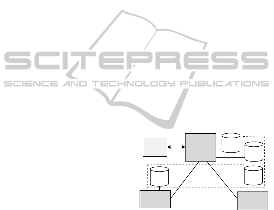
Fig.2 shows the WiCity architecture, where the
user mobiles are connected to a central RoR server.
Currently, all the needed information is stored in the
MySQL tables of the RoR server. We are also
developing a distributed version of WiCity where
the RoR server will use both local databases and the
remote XML/OWL data stores resident on the
proper remote servers (i.e., Sesame server). This
architecture will favour data integration, data
privacy and data updating according to the methods
outlined in sect.3.
Figure 2: Current centralized WiCity architecture. It is
conceived to support future integrations of XML/OWL
data stored on different remote servers.
Fig.2 points out that, currently, the user mobiles
may use only data stored on the RoR server,
whereas, in the future remote data may be used too.
In particular, data integration will be obtained by
connecting local and remote XML/OWL data stores
through messages exchanges between the web RoR
application stored on the RoR server and the Sesame
servers at distant service points.
The mobile interface, developed by
JQueryMobile, currently consists of some icons
User
Mobile
RoR
Server
MySQL
Tables
XML
OWL
Sesame
Server
N
Sesame
Server 1
XML
OWL
XML
OWL
. . . . .
LOCATIONINTELLIGENCESERVICESFORMOBILESUSINGRUBYONRAILSANDJQUERYMOBILE
767
concerning information on mobility and health
services, and on the best routes to reach the
destination from the current user position (fig.3.left).
Also, events/places of general interest are provided
to tourists and citizens (fig.3.right).
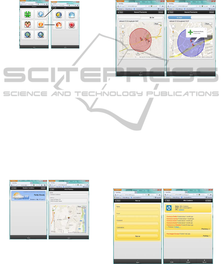
Figure 3: The interface icons of WiCity are chosen from a
predefined list: main interface (on the left) and events of
general interest (on the right).
The events of general interest consist of icons
chosen by the user from the list of available LBSs.
In particular, the one on the left_top in fig.3.rigth is
connected to an RoR process implemented on the
server that is able to access the weather metadata of
Yahoo. After having processed the JSON file
received from Yahoo such process extracts the
weather conditions of the area in which the mobile is
located, i.e., cloudy and 17 °C in fig.4.left.
Such data are not only useful to inform the user
on the current weather conditions but also to modify
the fuzzy sets associated to the concept nearest
service. The basic mobility and heath services (e.g.,
parks, gas stations, pharmacies and first aid points)
may be accessed either in alphabetical order to get
relevant information such as address, location on the
map, opening hours and so on (see fig.4 right), or by
the mentioned fuzzy facilities.
Figure 4: Weather info and localization of a pharmacy of
user interest chosen from a predefined list.
Currently, only fuzzy facility that take into
account the current traffic and weather conditions
are available; they are denoted as services nearest to
my current position. For example, fig.5 shows how
WiCity points out the pharmacies that may be
reached by walking or by car displaying the
corresponding markers within a circle of a suitable
radius obtained by using the mentioned fuzzy rules.
Figure 5: Pharmacies that may be reached by car (on the
left) and by walking (on the right) taking into account the
weather info and the user position.
To use the facilities of WiCity, any user should
be registered. In the information related to her/his
profile, WiCity includes automatically the items
inserted by the user so that they are available for the
other users of her/his community as shown in fig.6.
In this ways we should obtain two benefits:
• to encourage the users to insert information
useful for their community, and
• to avoid that they insert deliberately wrong
information.
The use of the registered information to provide the
users with e-government and e-commerce services
(e.g., certificates, event tickets, etc.) is for future
works.
Figure 6: Registration form (on the left) and list of the
items inserted by the user (on the rigth).
WEBIST2012-8thInternationalConferenceonWebInformationSystemsandTechnologies
768
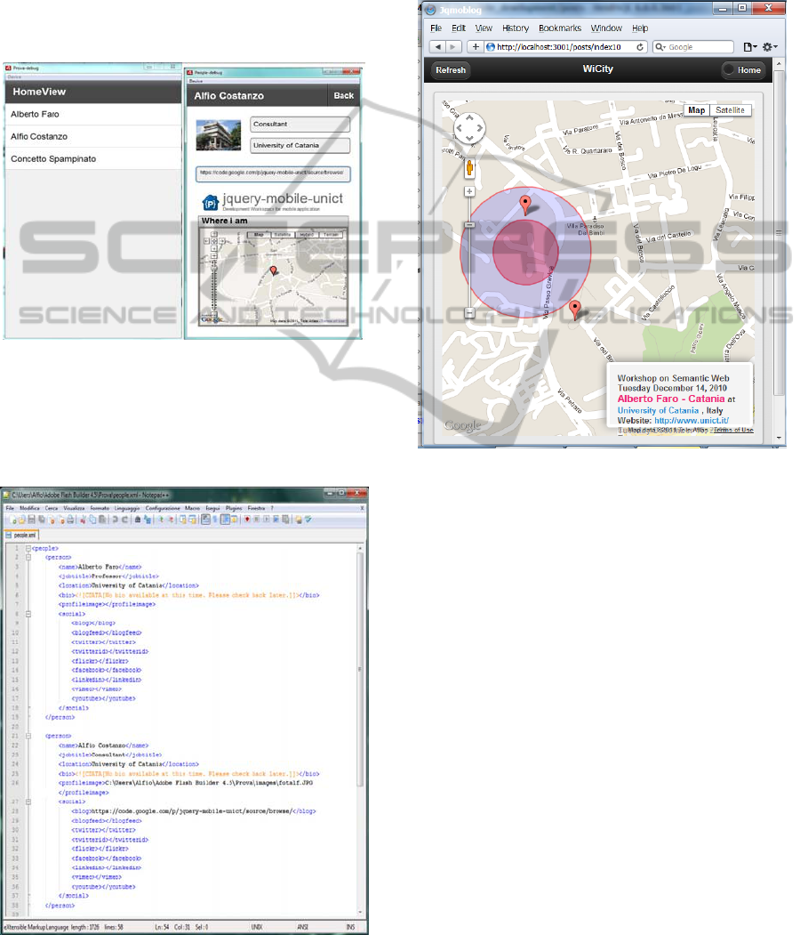
In fig.7 we show the WiCity mobile interface
obtained by using Flash Builder by Adobe (Gassner,
2010). The effort for developing this version of
WiCity is certainly lower than the one needed to
develop an RoR application powered by
JQueryMobile, but the organization of the data is not
so effective as the one supported by RoR that is
based on the well known paradigm Models-Views-
Controllers (Hartl, 20011).
Figure 7: Some WiCity snapshots in Flash Builder.
One positive feature of the Flash Builder
applications is that it may use XML-like files, as the
ones outlined in fig.8, stored locally or on a remote
server.
Figure 8: The XML file used by the Flash Builder
application installed on the user mobile.
A more powerful facility of using metadata may
be obtained by using the RoR framework. As an
example, WiCity makes possible the geo-
localization of the services by geo-markers whose
info windows are filled with the data extracted from
XML/OWL metadata as shown in fig.9 and fig.10.
Figure 9: Geo-localization of points that are reachable by
walking and by car. These points are related to the event
described in the window on the bottom. The data of the
event are taken from the metadata.
Finally, let us clarify in fig.11 how the
Directions API of Google Maps is useful to find the
intersections between two routes x and y in order to
obtain the function (x AT y) currently not available
for many countries.
Indeed, in fig.11.left the intersection between the
road named 'costarelli' and the one named 'del
toscano' is not pointed out by using Directions to
connect 'costarelli' and 'del toscano' with the option
by driving, whereas it is pointed out when it is
executed with the option by walking. Indeed, often
there is no intersection between two routes by using
Directions with the option by driving, since as
shown in fig.11.left, Directions takes into account
the one way streets. On the contrary, the information
contained in the info window of the function
Directions with the option by walking (e.g.,
fig.11right) allows us to discover the marker and
related geo-coordinates associated to the intersection
between the roads.
LOCATIONINTELLIGENCESERVICESFORMOBILESUSINGRUBYONRAILSANDJQUERYMOBILE
769
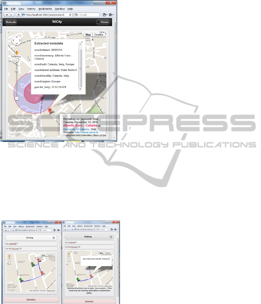
Figure 10: The info window associated to the points of
interest is filled with the data extracted from the metadata.
How to obtain all the intersections and to derive
the matrix that gives the adjacent intersections of
each traffic network intersection is outside the scope
of the paper and will be discussed in detail in future
works. Once such matrix is obtained, the
methodology proposed in sect.2.3 will allow us to
display on the user mobiles the current best route to
destination.
Figure 11: Route connecting the initial and final addresses
of two streets in search of the marker associated to their
intersection by driving (on the left) and by walking (on the
right).
5 CONCLUSIONS
The paper has widely discussed how the current
LBS applications may be improved by using fuzzy
rules and semantic technologies. The solutions
proposed would have the expected high impact since
the information will be based on real time updated
data stores.
Another expected positive feature of the
proposed web services is that the chosen
implementation approach favours the integration of
the disparate database available at metropolitan scale
thus opening concrete opportunities to develop
mobile-commerce and mobile-business applications
of wider utility.
Further studies are planned to evaluate how much
location intelligence should be embedded in the LBS
applications to really improve the location services
offered to the users.
Issues like decision support systems based on
fast data mining techniques (Faro, 2011c) and fast
image pre-processing, e.g., (Cannavò, 2006)
(Crisafi, 2008), for supporting people recognition
and people flow control in case of emergency should
take advantage from the possibilities of having
JQueryMobile based PDAs that are able to suggest
timely convenient alternatives in both security and
logistics fields to mobile users.
The applications presented in the paper are
currently under development within a project called
K-Metropolis supported by our Region to favour the
transition towards the knowledge society with the
aim of improving the level of competitiveness of the
local economic system.
Further applications of the proposed technologies
are also planned at our University to control physical
processes that may influence the people security and
the environmental quality such as control systems
that alert the drivers on the overflowing of a river by
indicating suitable escape routes, or emergency
systems that inform timely the policeman in case a
high pollution is affecting a certain area of the sea
(Spampinato, 2010).
REFERENCES
Allemang D., Hendler, J., 2011. Semantic Web for the
Working Ontologist: Effective Modeling in RDFS and
OWL, Elsevier Ltd, Oxford, 2011
Bai G., 2011. JQueryMobile. Packt Publishing, 2011
Bonomi A., Rondelli A., Vizzari G., Stride S.., 2007. An
Ontology Driven Web Site and its Application in the
Archaeological Context, 2nd International Workshop
WEBIST2012-8thInternationalConferenceonWebInformationSystemsandTechnologies
770

on Ontology, Conceptualization and Epistemology for
Software and System Engineering, 2007
Broekstra J. et al., 2002. Sesame: a generic architecture for
storing and querying RDF and RDF Schema. LNCS
Vol.2342, 2002.
David M., 2011. Developing Websites with
JQueryMobile. Focal Press, 2011
Cannavò F., Nunnari G., Giordano D., Spampinato C.,
2006. Variational Method for Image Denoising by
Distributed Genetic Algorithms on GRID
Environment. Proc. Int. Workshops on Enabling
Technologies: Infrastructure for Collaborative
Enterprises, WETICE '06. IEEE, 2006
Crisafi A., Giordano D., Spampinato C., 2008. GRIPLAB
1.0: Grid Image Processing Laboratory for Distributed
Machine Vision Applications. Proc. Int. Workshops on
Enabling Technologies: Infrastructure for
Collaborative Enterprises, WETICE '08, IEEE, 2008
Faro, A., Giordano, D., 1998. StoryNet: an Evolving
Network of Cases to Learn Information Systems
Design. IEE Proceedings SOFTWARE, 145(4), 119-
127, 1998
Faro, A., Giordano, D., 2003. Design memories as
evolutionary systems: socio-technical architecture and
genetics, Proc. IEEE International Conference on
Systems Man and Cybernetics, Vol.5, 4334-4339,
IEEE, 2003
Faro, A, Giordano, D. and Musarra, A., 2003. Ontology
based intelligent mobility systems. Proc. IEEE
Conference on Systems, Man and Cybernetics,
Washington, Vol.5, 4288-4293, IEEE , 2003.
Faro, A., Giordano, D., Spampinato, C., 2008. Evaluation
of the traffic parameters in a metropolitan area by
fusing visual perceptions and CNN processing of
webcam images. IEEE Transactions on Neural
Networks, vol.19(6), 1108-1129, IEEE, 2008
Faro, A., Giordano, D., Spampinato, C., 2011. Integrating
location tracking, traffic monitoring and semantics in a
layered ITS architecture, Intelligent Transport
Systems, IET, Vol.5(3), 197-206, IET, 2011
Faro, A., Giordano, D. and Spampinato, C., 2011.
Adaptive background modeling integrated with
luminosity sensors and occlusion processing for
reliable vehicle detection. IEEE Transactions on
Intelligent Transportation Systems. Vol. 12(4), 1398-
1412, IEEE, 2011.
Faro, A., Giordano, D., Maiorana, F., 2011. Mining
massive datasets by an unsupervised parallel clustering
on a grid: Novel algorithms and case study. Future
Generation Computer Systems, Vol. 27(6), 711–724,
2011.
Giordano, D., 2002. Evolution of interactive graphical
representations into a design language: a distributed
cognition account, International Journal of Human-
Computer Studies, Vol. 57(4), 317-345, 2002
McCubbin, R. P. Staples, B. L. and Mercer, M. R. 2003.
Intelligent Transportation Systems Benefits and Costs:
2003 Update, Mitretek Systems, Inc., Washington.
Gassner D., 2010. Flash Builder 4. Wiley, 2010
Hartl M., 2011. Ruby on Rails 3, Addison Wesley, 2011.
Knubblauch H. et al., 2004. Protege OWL Plugin (an open
development environment for semantic web
applications. Proc. ISWC 2004, LNCS Vol.3298, 229-
243, 2004
Kumari, S. M. and Geethanjali, N., 2010. A Survey on
Shortest Path Routing Algorithms for Public Transport
Travel, Global Journal of Computer Science and
Technology, Vol. 9(5), 2010.
Powers,S. 2003 Practical RDF, O’Reilly Media
Spampinato, C., Giordano, D., Di Salvo, R., Chen-Burger,
Y. H. J., Fisher, R. B., Nadarajan, G., 2010. Automatic
fish classification for underwater species behavior
understanding, in Proceedings of the first ACM
international workshop on Analysis and retrieval of
tracked events and motion in imagery streams,
ARTEMIS ’10, ACM, 45-50, 2010.
Wang P. P., 2001. Computing with words. Wiley
Inderscience, 2001
Wielemaker, J. Hildebrand, M. and Ossenbruggen, J.
2009. Using Prolog as the fundament for applications
on the semantic web, hcs.science.uva.nl/projects/SWI-
Prolog/ articles/mn9c.pdf, 2009.
Zhai, J., Jiang, J., Yu, Y. and Li, J., 2008. Ontology-based
Integrated Information Platform for Digital City, IEEE
Proc. Of Wireless Communications, Networking and
Mobile Computing, WiCOM '08, IEEE, 2008.
LOCATIONINTELLIGENCESERVICESFORMOBILESUSINGRUBYONRAILSANDJQUERYMOBILE
771
