
ORGANIZING GEOSPATIAL TECHNOLOGY LEARNING FOR
INTERDISCIPLINARY URBAN STUDIES EDUCATION
Wei“Wayne” Ji
Department of Geosciences, University of Missouri – Kansas City, 5100 Rockhill Road, Kansas City, U.S.A.
Keywords: Geospatial Technology, Learning Organization, Community Building, Interdisciplinary Education.
Abstract: This article introduces an on-going effort to establish a GIS certificate program to organize relevant
teaching and research resources for a geospatial technology-supported urban studies education. The project
starts from recognizing the challenge in integrating all related disciplines for interdisciplinary urban studies
education due to its multidisciplinary nature. To address this challenge, the project identifies the common
interest and need among related disciplines: all require an understanding of geographical patterns of study
subjects. The article discusses the efforts of establishing a GIS certificate program as a framework for
learning organization and community building, which include selection of participating academic
disciplines, curriculum design, program implementation, and outreach activities. Increased student
enrolment and activities indicate that the GIS certificate program can effectively organize teaching and
learning resources for interdisciplinary urban studies education.
1 INTRODUCTION
As the only comprehensive higher education
institution in the Kansas City metropolitan area, an
industrial and economic centre in central United
States, the University of Missouri – Kansas City
(UMKC) commits itself to excellence of education
in urban studies. This is a challenging task because
urban studies involve multidisciplinary efforts across
academic units, such as environmental research,
socioeconomic analysis, business investigation,
policy studies, and public health service. Facing this
challenge, the professors of relevant disciplines
sought to identify the common interest among them
in order to develop interdisciplinary collaborations.
As all of the academic disciplines require, more or
less, an understanding of geographical patterns of
study subjects in research and teaching, they
identified geospatial data analysis as the common
approach in relevant teaching, learning, and research
for all the disciplines. The consensus was reached to
establish a computer-supported geospatial
technology education program that organizes
teaching and learning resources of the participating
disciplines for interdisciplinary education.
Consequently, Advanced Certificate Program in
Geographic Information Systems (GIS) (“the GIS
certificate program”) was established in 2006. This
program has successfully enrolled a large number of
students. The program helped innovating curricula
of participating disciplines and facilitated
participating professors to integrate their research
interests and findings into teaching, which have
significantly promoted interdisciplinary urban
studies education. This article introduces the
organization of the GIS certificate program, its
curriculum design, and its implementation. It also
discusses how to integrate research into teaching and
learning and how to outreach professional
communities to expand the learning community
beyond the university campus.
2 ORGANIZING GEOSPATIAL
TECHNOLOGY LEARNING
COMMUNITY
GIS is one of the most pervasive of today’s
information technologies. Increasingly, our society
relies on geospatial information about the location of
people, resources, things, and events (Chang, 2010).
Additionally, access to geospatial data has become
universally available with rapid evolution of
Internet-based tools (Scharl and Tochtermann, 2007;
Tanaka, et al., 2011). Increasing demands for GIS-
291
“Wayne” Ji W..
ORGANIZING GEOSPATIAL TECHNOLOGY LEARNING FOR INTERDISCIPLINARY URBAN STUDIES EDUCATION.
DOI: 10.5220/0003958202910294
In Proceedings of the 4th International Conference on Computer Supported Education (CSEDU-2012), pages 291-294
ISBN: 978-989-8565-07-5
Copyright
c
2012 SCITEPRESS (Science and Technology Publications, Lda.)

related techniques provide new opportunities in
higher education. Traditional geospatial analyses,
such as geographic visualization, environmental
mapping, urban planning, location-based
socioeconomic studies, disease surveillance, crime
location analysis, and public information
management can now be conducted with GIS-related
techniques. Like many other higher education
institutions, more and more academic disciplines
(academic departments and degree programs) at
UMKC have developed GIS-based disciplinary
courses. However, how to effectively organize
individual geospatial technology-based courses into
an interdisciplinary teaching and learning framework
has become a challenging task. At UMKC, involved
professors believed that accomplishing this task
required a new thinking for learning organization.
For this, the decision was made to establish a GIS
certificate program as a framework to build a
geospatial technology learning community.
Figure 1 shows the conceptual design of the
learning community: an overarching GIS certificate
program that internally integrates any academic
discipline which can contribute geospatial
technology-based courses at UMKC and externally
links to professional communities (industries,
businesses, governmental agencies, and
organizations). Accordingly, the student body of the
program comes from two sources: regular degree-
seeking students and working professionals. The
GIS certificate program organizes all of the
discipline-based geospatial technology teaching and
learning by setting up the core courses and the
elective courses toward the completion of the
certificate program. As learning support, the
program hosts workshops joined by professors,
students, geospatial technologies professionals, and
business leaders to promote collaborations between
academic programs and professional communities.
The GIS certificate program also coordinates student
internships at industries and agencies to help them to
gain practical experiences. Through all of these
efforts, the geospatial technology learning
community was successfully supported.
Establishing such a GIS certificate program
involved the following procedures: selection of
participating academic disciplines, curriculum
design, program implementation, and outreach
activities.
The participating academic disciplines were
selected based on two considerations: The discipline
can contribute to an area of urban studies, and it can
offer or develop geospatial technology-based
disciplinary courses. Consequently, the certificate
program embraces six academic disciplines:
Geosciences, Urban Planning, Sociology,
Economics, Criminal Justice & Criminology, and
Computer Science. More disciplines can be included
when they meet the selection criteria. The program’s
coordinating committee consists of the involved
professors of the participating disciplines. Table 1
shows the geospatial technology-based courses
contributed by these academic disciplines.
Table 1: Participating disciplines and curriculum.
Disciplines Program Curriculum
Geosciences
•
Introduction to GIS
• Advanced GIS
• Environmental
Remote
Sensing & Digital
Image Analysis
• Spatial Data Analysis
• Satellite Climatology
• Advanced Topics in
GIS & Remote Sensing
Urban Planning
•
Advanced GIS for
Urban Planning
• Quantitative Planning
Methods & Techniques
Sociology
•
Spatial Thinking in
Social Science
Economics
•
Economic Statistics
Criminal Justice
& Criminology
•
Advanced GIS for
Crime Analysis
Computer Science
•
Database Design,
Implementation &
Validation
• Data Structure &
Algorithms
The GIS certificate program is open to any
regular students and working professionals who
have had appropriate academic backgrounds. Their
admission applications are evaluated for approval by
the program director. There is no time limit for the
students to complete this certificate program. In
order to obtain the certificate, the student needs to
finish five relevant courses as listed above with a
grade point average (GPA) of 3.0 or above,
including two required core courses: Introduction to
GIS and Advanced GIS. Students can select freely
elective courses and receive academic advice and
other support through any participating disciplines.
CSEDU2012-4thInternationalConferenceonComputerSupportedEducation
292
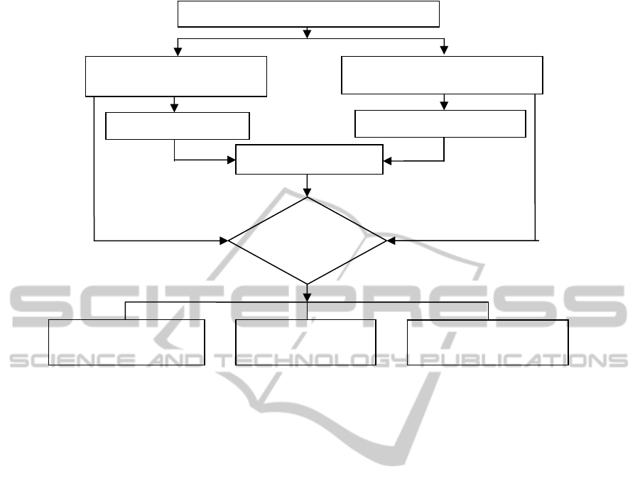
Figure 1: Conceptual design of learning community.
3 INNOVATING GEOSPATIAL
TECHNOLOGY TEACHING
AND LEARNING
A successful interdisciplinary education program,
which is based on integration of individual
geospatial technology courses, must be built up on
teaching and learning innovation. To reach this goal,
the following measures have been taken: (1)
Integrating the participating professor’s research into
his/her teaching, (2) guiding students to conduct
research as part of their course learning, and (3)
providing web-based teaching and learning support.
Located in a metropolitan area, almost all the
participating professors have conducted their
research in relation to urban issues which are
location-based and implementable with geospatial
techniques. In their teaching, the professors
demonstrated their research issues and findings to
the students as case studies, future research issues,
and / or innovative geospatial methods. Motivated
students were guided to conduct class projects as
part of their certificate courses. The students were
supervised by their course instructors to learn how to
identify research issues, develop technical
approaches, implement research, and present
research findings. The class research projects are
required to be conducted with the geospatial
methods learned from specific geospatial technology
courses. To better support the students who want to
pursue an in-depth research, the GIS certificate
program has developed independent study courses at
both graduate and undergraduate levels – Advanced
Topics in GIS and Remote Sensing. This course
allows a participating student to design and conduct
his/her own research independently. The student
usually determines a research topic of his/her
interest with the corresponding instructor. At the end
of the course, the student submits the project report
to the instructor for evaluation. To facilitate
computer-supported teaching and learning with
geospatial techniques, the GIS certificate program
has developed and maintained a central geospatial
database which resides on the university’s website
for students to have access. The database serves as a
geospatial data warehouse that stores professors and
students’ past project data or the data from other
sources, which may be useful for students’ future
projects. The GIS certificate program also collects
digital satellite images, which are used for students
to learn satellite remote sensing techniques and
study urban landscape changes. Additionally, the
UMKC Library has developed a web-based library
guide specifically for geospatial technology
information inquiry and acquisition, which covers
Advanced Certificate Program in GIS
Participating Academic
Disciplines
Professional Communities
Student Bod
y
Regular Students
Working Professionals
Progra
m
Activities
Geospatial Technology
Teaching & Learning
Student Internship
Coordination
Professional Workshops
and Meetings
ORGANIZINGGEOSPATIALTECHNOLOGYLEARNINGFORINTERDISCIPLINARYURBANSTUDIES
EDUCATION
293

digital journals and online publications, web links of
various geospatial data sources, and geospatial
events. In the past several years, the students
developed a large number of computer-supported
geospatial research projects which covered almost
all areas of urban studies and were innovatively
integrated with their disciplinary course learning.
The effectiveness of the described geospatial
technology learning organization was justified by
increasing student enrolment with the GIS certificate
program. To further measure the effectiveness of the
students’ learning, a learning assessment method is
under development, which is based on evaluations of
students’ coursework and research projects in
relation to specific learning goals / sub-goals.
4 EXPANDING THE LEARNING
COMMUNITY BEYOND THE
UNIVERSITY CAMPUS
The Kansas City metropolitan area has a large
community of geospatial technology research,
development, and application. Several leading
geospatial mapping companies are headquartered in
the region, such as Garmin International, Inc. (a
world leading GPS company). ESRI, Inc. (a world
leading GIS developer) has its regional office in
Kansas City. Many companies, businesses, and
governmental agencies in this region have been
using geospatial techniques like GIS for their
projects and operations, such as city planning,
engineering projects, and environmental
management.
The GIS certificate program considers that it
would be very beneficial to expand university’s
geospatial technology learning community beyond
the university campus by developing close
collaborations with the region’s professional
communities. To reach this goal, the program has
developed various joint activities that involve
professors, students, working professionals, and
business leaders for collaborations.
The GIS certificate program hosted annual
geospatial information events, including GIS users
meetings, GIS business forums, and / or public
workshops. During these events, professors,
students, geospatial professionals, governmental
officials, and business managers presented new
technologies, research projects, and policy opinions.
These activities helped students to connect
themselves to relevant businesses and professional
communities, better understand societal needs, and
develop internships or employment relationships
with industries, businesses, and agencies.
The GIS certificate program also invited
geospatial professionals, scientists, and business
leaders to provide guest lectures to the community
of learners.
5 CONCLUSIONS
With a geospatial technology-oriented curriculum
and organized learning-support activities, the GIS
certificate program effectively organizes teaching
and learning resources of relevant academic
disciplines for interdisciplinary education.
Integrating research into teaching and learning
motivates students to explore computer-supported
geospatial methods to solve real world problems
through their course studies.
The geospatial technology learning community
that bridges the university and professional
communities facilitates students’ connection to
relevant businesses and professional organizations
and helps them to better understand technology
advancement, societal needs, and job market.
REFERENCES
Chang, K. T. 2010. Introduction to Geographic
Information Systems. McGraw-Hill, Sixth Edition.
Scharl, A. and K. Tochtermann (editors). 2007. The
Geospatial Web: How Geobrowsers, Social Software
and the Web 2.0 are Shaping the Network Society.
Springer, First Edition.
Tanaka, K., P. Fröhlich, and K. Kim (Editors). Web and
Wireless Geographical Information Systems:
Proceedings of 10th International Symposium, W2GIS
2011, Kyoto, Japan, March 3-4, 2011.
CSEDU2012-4thInternationalConferenceonComputerSupportedEducation
294
