
ArchaeoApp Rome Edition (AARE): Making Invisible Sites Visible
e-Business Aspects of Historic Knowledge Discovery via Mobile Devices
Katharina Holzinger
1
, Gabi Koiner
1
, Primoz Kosec
2
, Markus Fassold
2
and Andreas Holzinger
2
1
Institute of Archaeology, Karl-Franzens University Graz, Graz, Austria
2
Research Unit Human-Computer Interaction, Institute for Medical Informatics, Statistics and Documentation, Graz, Austria
Keywords: Information Retrieval on Mobile devices, Knowledge Management, e-Business, Archaeology, Classics,
History, e-Business, Tourists.
Abstract: Rome is visited by 7 to 10 million tourists per year, many of them interested in historical sites. Most sites
that are described in tourist guides (printed or online) are archaeological sites; we can call them visible
archaeological sites. Unfortunately, even visible archaeological sites in Rome are barely marked – and
invisible sites are completely ignored. In this paper, we present the ArchaeoApp Rome Edition (AARE).
The novelty is not just to mark the important, visible, barely known sites, but to mark the invisible sites,
consequently introducing a completely novel type of site to the tourist guidance: historical invisible sites.
One challenge is to get to reliable, historic information on demand. A possible approach is to retrieve the
information from Wikipedia directly. The second challenge is that most of the end users have no Web-
access due to the high roaming costs. The third challenge is to address a balance between the best platform
available and the most used platform. For e-Business purposes, it is of course necessary to support the
highest possible amount of various mobile platforms (Android, iOS and Windows Phone). The advantages
of AARE include: no roaming costs, data update on demand (when connected to Wi-Fi, e.g. at a hotel, at a
public hotspot, etc. ... for free), automatic nearby notification of invisible sites (markers) with a Visual-
Auditory-Tactile technique to make invisible sites visible.
1 INTRODUCTION
1.1 Motivation for Research
Most sites that are described in tourist guides
(printed or online) are archaeological sites; we can
call them visible archaeological sites. Unfortunately,
even visible archaeological sites in Rome are barely
marked – and invisible sites are completely ignored.
The novelty of the ArchaeoApp Rome Edition
(AARE) is not just to mark the important visible but
barley known sites, but to mark the invisible sites,
consequently introduces a completely novel type of
site to the tourist guidance: historical invisible sites.
Moreover, AARE provides two modes: standard
tourist mode and a scavenger hunt modus, where it
makes use of powerful game-based learning
concepts (Mayo, 2009), (Hoffmann, 2009). This is
definitely an issue of e-Business since, according to
Marca et al. (2012), e-Business needs to cope with
the behaviour and requirements of Digital Natives
(Prensky, 2001), which is the generation growing up
with the Internet and having a great degree of
competence concerning the usage of mobile Web
services.
Consequently, digital natives are well informed
and assertive regarding products they want to buy
(Marca et al., 2012).
It is important to first understand the difference
between archaeological sites and historical sites. The
subject of Archaeology is to find and document
material of ancient cultures, including buildings,
houses, weapons, tools and even stuff that ancient
people threw away. However, the subject of History
is a different issue, namely the analysis of events
and actions. For that, historical sites are invisible
because they are one-dimensional. They only exist
in the fourth dimension, similar to an interface in a
Harris matrix (Harris, 1979). However, historical
sites are attached to special places.
A good example is the battle at the Milvian
Bridge (Speidel, 1986). This was the final battle
115
Holzinger K., Koiner G., Kosec P., Fassold M. and Holzinger A..
ArchaeoApp Rome Edition (AARE): Making Invisible Sites Visible - e-Business Aspects of Historic Knowledge Discovery via Mobile Devices.
DOI: 10.5220/0004074801150122
In Proceedings of the International Conference on Data Communication Networking, e-Business and Optical Communication Systems (ICE-B-2012),
pages 115-122
ISBN: 978-989-8565-23-5
Copyright
c
2012 SCITEPRESS (Science and Technology Publications, Lda.)

between the two rivals Maxentius and Constantine in
October of the year 312 AD. This battle is not only
significant as the start of the Constantinian Dynasty,
but can in some way also be seen as the beginning of
the rise of Christianity, for Constantine was the first
Emperor to equate Christianity completely with the
pagan religion. Interesting for us is that this battle
was a historical event with no archaeological
evidence left. However, there are reports of roman
writers, which allow us to reconstruct the battle site
– stretching from the town of Prima Porta to the
name giving bridge in Rome. Another brilliant
example is the route of the roman triumph, a circle
line through the city; or sites of events, such as the
murder of Julius Caesar, the murder of Tiberius
Gracchus, the site where the ritual declaration of war
took place. Our basic idea is to raise awareness for
such historical sites by marking them with
coordinates and to create a mobile application,
which alerts an interested visitor when reaching such
a site. Consequently, we built on previous work
(Holzinger et al., 2011a), (Holzinger et al., 2011b)
and designed, developed, implemented and tested a
so-called ArchaeoApp Rome Edition (AARE).
According to Marca et al. (2012) e-Business needs
to cope with the behavior and requirements of
“digital natives.” The generation of the digital
natives grew up with the Internet and has a great
degree of competence concerning the usage of
Internet services. Digital natives are well informed
and assertive regarding products they want to buy
1.2 Challenges and Approaches
The implementation of the AARE idea is not trivial
and there are several different approaches for a
solution.
(1) The first challenge is related to information
retrieval: How to bring the historical content to the
mobile device on site. One possibility is that experts
in classics prepare special content and put it on a
Web server, which can be accessed from the mobile
device on demand. The more charming possibility is
to make use of already existing content on
Wikipedia and, since it is an open site, that experts
in classics provide special content in Wikipedia
directly. The challenge is to crawl through the
existing sources and to retrieve relevant data for
display on the mobile device on site.
(2) This brings us immediately to the second
challenge: In commercial mobile telephone
networks, the call setup to an international roaming
subscriber is always routed through the home
network of the subscriber, which results in the usage
of two expensive international telephone trunks.
Apart from some technical solutions (Sardag, 2011),
(Yi-Bing et al., 2011), mostly, the tourists just
disable their Internet access. Our solution is to make
use of existing wireless access points as they are
available mostly in hotels, public places, or
restaurants (e.g. McDonalds).
(3) The third challenge is not less challenging:
Tourists have a variety of mobile devices. Based on
Gartner’s report for the 4
th
quarter in 2011, there was
an evident Android dominance (50.9%) of the
world-wide smartphone sales. The iOS ranked
second with 23.8% of sales, Symbian third (11.7%)
and Black Berry forth (8.8%). The truth is that
Android is growing faster due to the diversity of
manufacturers.Moreover, the AARE can be adapted
to two different levels: Standard Guiding Modus,
and Scavenger Hunt Play Modus; which brings us to
the fourth challenge.
(4) In our previous work, we made good
experiences with scavenger hunts (Holzinger et al.,
2011b), borrowing powerful concepts from game-
based learning – which, together with mobile
technologies offers enormous potential in the future,
especially from an e-Business perspective
(Bulander, 2010). It can be used for both educational
and play purposes. Essential elements of this play
(timed task, teamwork, mobility) can be used for a
collaborative problem-solving approach; such team
based learning was early recognized as important
(Hutchings et al., 1993): End-users are confronted
with a problem, which is usually more easily solved
by the collective intelligence of the whole group
(Massimi et al., 2007). Collective Intelligence is
currently of high interest among researchers, due to
the fact that there are effects regarding the
performance of individuals on a wide variety of
cognitive tasks (Woolley et al., 2010). Recent
research showed that different collaboration models,
strategies, as well as atmospheres could greatly
influence the performances of its members. In
collaboration, each individual can have better
learning effectiveness (Shih et al., 2010).
2 BACKGROUND
2.1 Milvian Bridge – Historical
Landmark for Christianity
We explain AARE on a first practical example:
Assume you are a historically interested visitor of
Rome. Assume you are just approaching the Milvian
Bridge (Figure 1). AARE automatically detects that
ICE-B 2012 - International Conference on e-Business
116
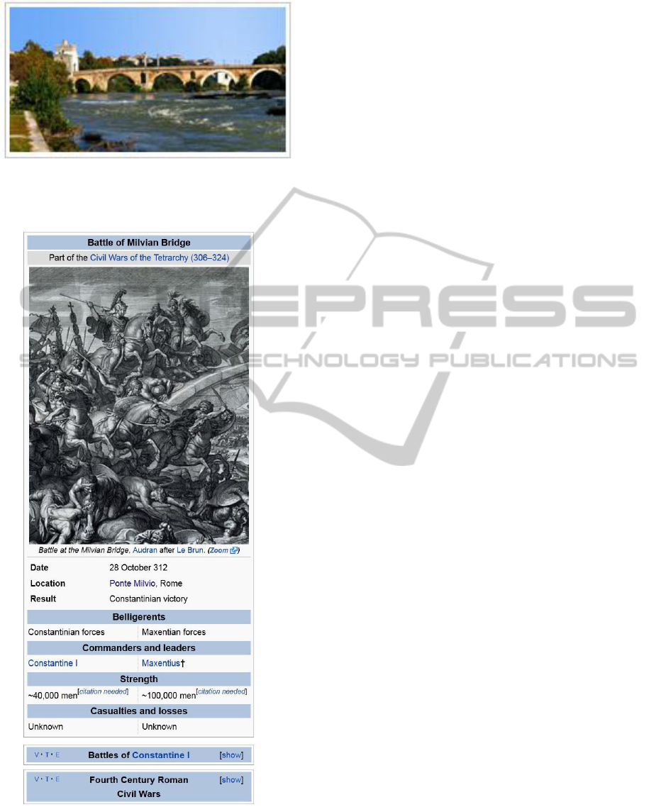
Figure 1: The Milvian Bridge, as the visitor sees it today
(image taken from Wikipedia: http://en.wikipedia.org/
wiki/Battle_of_the_Milvian_Bridge).
Figure 2: Structured Information to the Battle of the
Milvian Bridge from Wikipedia (see link below Figure 1).
there was a historic event, because it checks
automatically for the coordinates from Wikipedia
(Figure 2) and retrieves it, because the coordinates
have been marked by a qualified historical and/or
archaeological expert as a so-called “invisible site”.
The end user is then reminded by vibration, visual,
or acoustic signal that she/he is in range of an
invisible site. Now the information will be displayed
directly on the smartphone (Figure 2).
The Milvian Bridge is located 41° 56’ 7.8’’ N,
12° 28’ 1.1’’ E.
The battle of the Milvian Bridge was a
significant event in late antiquity, because it was the
event that ended the war between Constantine and
Maxentius. Constantine was victorious, after he had
drawn the Christian symbol Chi Rho on his shields,
as commanded in a vision he had. Although
Constantine himself probably was no Christian, he
sympathized with Christianity and stood at the
beginning of its upraise.
2.2 Theatre of Pompey – The Site of
Caesars Murder
As further nice example for an invisible site we
present the Theatre of Pompey (Claridge, 2010) –
where it is not visible that here Caesar died. In
Figure 3, we clearly see that there is not much to see
today on this classical site. The Theatre of Pompey
is located at 41° 53’ 43’’ N, 12° 28’ 25’’ E.
The eastern end of this first century BC building,
is today located beneath the Via di Torre Argentinia.
In ancient times, there was an annex where Senate
meetings where held, further this is the very site
Julius Caesar was murdered on 15
th
March 44 BC.
The blue dot in Figure 3 marks the location
Caesars murder took place. It was at the eastern end
of the building, which once contained an annex
where Senate meetings were sometimes held. Today,
it lies under the Via di Torre Argentinia (Figure 4).
2.3 Selected Points of Interest
Here some points of interests as further examples:
Domus Aurea 41° 53’ 29’’ N, 12° 29’ 43’’ E
This was the private house of Nero, which he
intended to build within the City of Rome. It was
never fully completed, because it was destroyed
shortly after Nero committed suicide. The fact that
this is a type of building not supposed to be built in
the centre of a city is the main cause why the people
of Rome hated Nero.
Temple of Bellona 41.89’ 24’’N, 12.4799° E
In roman times it was important to justify a war in
front of the gods and declare it a bellum iustum.
ArchaeoApp Rome Edition (AARE): Making Invisible Sites Visible - e-Business Aspects of Historic Knowledge Discovery
via Mobile Devices
117
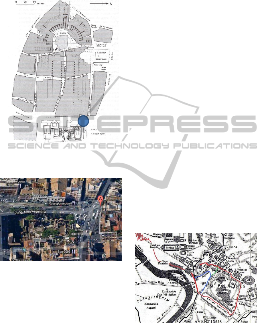
Figure 3: The archaeological site: The Theatre and
Porticus of Pompey as described in the Oxford
archaeological guide, the blue spot marking
the murder of Caesar (Claridge, 2010).
Figure 4: The visible site: To the beholder it is not clear
that A was the location of the murder of Caesar (Image
taken from Googlemaps).
For more information on Curia, assassination of Caesar:
http://en.wikipedia.org/wiki/Theatre_of_Pompey.
Very important was the ceremony of war
declaration; the ritual throwing of a wooden spear
across the enemy border to confirm the war. With
the expansion of the Roman Empire one was forced
to create a symbolic enemy territory within the city
of Rome.
Circus Maximus 41° 53’ 10’’ N, 12° 29’ 9’’ E
It was probably the biggest arena of all times;
although the details on the capacity vary between
300,000 and 500,000 spectators. Throughout its
almost 1000 years of existence the Circus Maximus
was the site of countless historic events, the most
drastic probably would be the great fire of Rome,
which had its origin within one of the shops located
in the Circus.
Solarium Augusti 41° 54’ 11.38’’ N 12° 28’
42.75’’ E
8This was the largest ancient sundial. It consisted of
a 30 meter high Egyptian Obelisk that Augustus had
erected in 10 BC, at the twentieth anniversary of the
conquest of Egypt. This solar meridian was designed
by the mathematician Facundus Novius. Its purpose
was to demonstrate the accuracy of the new
calendar, which had already been introduced by
Julius Caesar.
Ara Pacis 41° 54’ 23’’ N, 12° 28’ 32’’ E
This Altar is the most famous example for Augustan
monumental sculpture in Rome. It was decreed by
the Senate on 4 July 13 BC to celebrate Augustus’
return after three years’ absence in Spain and Gaul.
Today the Altar is not at his original location but in a
separate museum. Originally it was on axis with the
great obelisk of Augustus solar meridian.
Very interesting is the Route of Triumph (see
Figure 5), consisting of the following POIs – used of
the AARE Scavenger hunt:
Campus Martius 41° 53’ 52’’ N, 12° 28’ 38’’ E
Circus Flaminius 41°53’ 34’’N, 12°28’ 39’’ E
Forum Boarium 41° 53‘ 20‘‘ N, 12° 28‘ 52‘‘ E
Circus Maximus 41° 53’ 10’’ N, 12° 29’ 9’’ E
Forum Romanum 41° 53’ 31’’ N, 12° 29’ 12’’ E
Kapitol (Rom) 41° 53’ 36’’ N, 12° 28’ 58’’ E
Figure 5: The route of the triumph processing for our
Scavenger hunt game (Image from (MIT, 2012)).
ICE-B 2012 - International Conference on e-Business
118
3 SYSTEM ARCHITECTURE
According to a recent Gartner study
(www.gartner.com/it/page.jsp?id=1622614) Android
will command nearly half of the worldwide
smartphone operating system market by the end
2012. They predict that Apple’s iOS will remain the
second biggest platform worldwide through 2014.
Based on these predictions, we decided on the
Android platform, rather than the one used for the
previous ArcheoApp (Holzinger et al., 2011a),
(Holzinger et al., 2011b). There are two mode types
available in the AARE: tourists and scavenger hunt.
Both types include similar features; the difference is
in how the invisible sites or hints are shown.
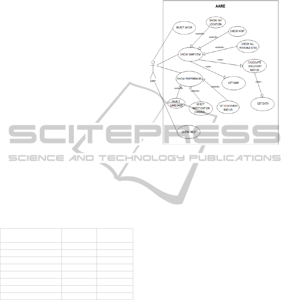
3.1 Features Overview
The use of GPS has few disadvantages s.a. potential
failures (battery consumption) and ambiguity
(atmospheric conditions or buildings may prevent
accuracy); however the biggest advantage from the
business perspective is that it works at no cost.
There are two types of modes available in the
AARE as mentioned before:
(a) Standard Guiding Modus and
(b) Scavenger Hunt Play Modus,
both modes include similar features; the difference is
in how the invisible sites or hints are shown.
Table 1: Feature comparison of modes in AARE.
Tourists
Scavenger
Hunt
Map view
My location
All invisible sites
Next hint
Notification channels
Discovery radius
Multilanguage
Help
After the mode type has been selected, a map
view is shown to the user. The map view is based on
the Mapsforge (Mapsforge, 2012) toolbox for fast
on-device rendering of OpenStreetMaps data on the
Android platform. It is released under the free and
open source LGPL3 license.
Users can select their preferable language in the
preference area, which consequently affects the
notification channels (visual & audio). Moreover,
they can set the discovery distance (radius) of
invisible sites. A function for calculating the
discovery radius checks against the data and shows
Figure 6: Use case diagram of AARE application.
dynamically invisible sites on the map view.
In tourists mode users have an option to see
available invisible sites; however this features is
omitted in the Scavenger Hunt where users can
invoke the next hint button instead. The users get an
instructional description by invoking the help button.
3.2 Data Structure
All data (images, content and maps) are stored
externally on the Secure Digital (SD) card.
The descriptors of invisible sites are defined as
XML files and are structured as following:
id (type: long) – unique identifier
mode (type: text) – tourists or scavenger hunt
language (type: text) – language of the text
description (type: text) – description of the
invisible site
image (type: text) – name of the image
latitude (type: ) - latitude coordinate
longitude (type: numeric) - longitude coordinate
In this way, a higher flexibility for further
releases was ensured (i.e. migrating to different data
storage, size of file system and performance wise).
3.3 Data Updates
A server-side Content Management System (CMS)
for authoring invisible sites is used by authors
(archeologists) who can create, edit, delete and
update invisible sites online.
ArchaeoApp Rome Edition (AARE): Making Invisible Sites Visible - e-Business Aspects of Historic Knowledge Discovery
via Mobile Devices
119
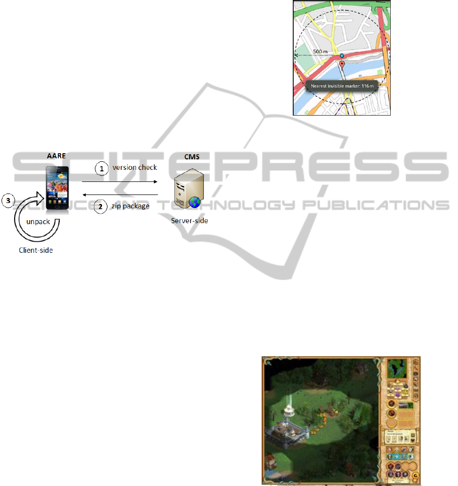
On the client-side, an update feature for
retrieving the data from the server-side handles the
synchronization process. When the AARE is
installed on a mobile phone, the update is automatic.
This procedure is shown on Figure 7. First the
AARE sends a request call to the server-side web
address and checks if a new version is available (1).
Next, a compressed package in a zip file format,
containing XML files, images and a map is pulled
down (2). At last the application unpacks the zip
package locally and structures the content
hierarchically (3). The hierarchy is based on folder,
wherein each folder represents an invisible site.
The data update on demand comes very handy
when travelling abroad. It lowers the costs since
users can use free Wi-Fi connections, for example at
a hotel or at public hotspots.
Figure 7: Procedure of data update in AARE.
3.4 User Mode: Tourist
Tourists can discover invisible archeological sites
based on the GPS location. The AARE application
first locates the user over GPS coordinates (gets the
latitude and longitude values from device) and
displays the user's location in a map view as shown
in Figure 8.
However, the invisible sites (presented as red
markers) are not visible immediately. Red markers
on the map become visible when the distance
between the user and the marker is inside the
discovery radius, in our case the default value of the
discovery radius is 500 meters but can be changed in
preferences. When this happens, the user is notified.
Notifications and information delivery can be set
in three ways, depending on the user’s preferences:
(a) Visual - tapping the marker on the map shows
an image with description of an invisible site
(b) Auditory - using the Android speech synthesis.
The Text-to-Speech (TTS) capability notifies
the nearest invisible site and read its description
(c) Tactile - vibration alerts to the next invisible site
The notification channels in the AARE represent
a novel approach and reflect similar characteristics
to Visual – Auditory – Kinesthetic – Tactile
(VAKT) learning styles (Boyles & Contadino,
1998). In this way, the users can select their
preferable notification channel according to their
needs for the newly acquired information.
Figure 8: A view on the AARE - blue circle represents the
user’s GPS location, the red pin is the nearest invisible site
which remains inside the discovery radius (500 m).
3.5 User Mode: Scavenger Hunt
The Scavenger Hunt uses the GPS location to unlock
further hints. The idea behind the Scavenger Hunt of
AARE is based on the concept of shade
(Ramachandran, 1988), revealing from the PC game
franchise Heroes of Might and Magic.
The principle of the shading conceptuality can be
seen in Figure 9, used originally in Warcraft I, II &
III, which is the most subscribed online game,
according to a paper from Science (Mayo, 2009).
Such games have potential to dramatically change
how people interact, navigate Web sites, and finally
conduct business (Mennecke et al., 2007), (Petrova
and Qu, 2007) so we took such examples very
serious.
Figure 9: Shading conceptuality (Gamespot, 2002) – there
is now no shading effect in World of Warcraft, since it
uses now a different playing paradigm.
The user in AARE discovers the map based on the
first destination hint. There are no markers visible on
the map at the start when the first hint is revealed
(usually a text-based description but it can also be a
ICE-B 2012 - International Conference on e-Business
120

picture); however when the user starts moving, the
marker (next hint) becomes visible when the user is
inside the discovery radius. The Scavenger Hunt
requires a locked value of the discovery radius and
cannot be changed by the user. This is a security
precaution to prevent cheating.
4 E-BUSINESS ASPECTS
Similar to the ArchaeoApp (Holzinger et al., 2011b)
AARE can bring several benefits:
On a Business-to-Consumer level (B2C) there is
a mass market in tourist areas on a personal level,
where people can download AARE for a small fee.
In March 2012 Google announced the Google Play
digital content service, which represents a unified
marketplace for music, movies, books and
applications. Purchases can be made by using the
Google Wallet system (formerly known as Google
Checkout) for simplifying the payment process.
On a Business-to-Business level (B2B), AARE
can be interesting for a mass market in large towns
with a historic background (e.g. Rome, which is a
good example, due to its 7M+ visitors per year).
However, we emphasize that this might be of equal
interest for smaller towns, open-air museums or
archaeological finding places. A good example is
Carnuntum, formely in the Roman province of
Pannonia (now Lower Austria), where only a few
people know that it contains the largest
Amphitheatre, outside the City of Rome.
It is proven that customer interactions can create
opportunities for positive experiences leading to
long-term relationship building (Rose et al., 2011).
This can be especially relevant for tourism.
Moreover, by using AARE as an attractive
customer benefit, the circle is closed by offering the
big advantage of raising awareness for our cultural
heritage – thus combining both aspects: e-education
and e-business.
5 CONCLUSIONS
We tested AARE on a small scale and it worked
well – real-world demonstration will be given in
Rome. The novelty is in the automatic detection of
an invisible site whilst avoiding roaming costs. The
advantages of AARE are threefold:
First, it represents an automatic invisible site
detection based on Visual-Auditory-Tactile (VAT)
notification channels, where the origins can be found
in Visual-Auditory-Kinaesthetic-Tactile (VAKT)
learning styles. By using all three types of
notification channels (description-speech-vibration),
users have the ability to choose their preferable
channel when receiving the information.
Second, the invisible sites (or hints in scavenger
hunt mode) are revealed inside the discovery radius
by using the shading concept. Based on the user’s
GPS location the discovery radius calculates
dynamically the radial distance to nearest invisible
site and notifies the user if the invisible site has been
discovered. Furthermore, the shading concept gets
especially useful for collaborative problem-solving
assignments in scavenger hunt where users unlock
next hints with their GPS location.
Third, the AARE uses GPS services in
combination with offline maps, avoiding roaming
costs. The users need to update the application
before they travel or by using the wireless network
to get the latest data. In the current version of
AARE, the data are stored in the database manually
using the SQLite Database Browser visual tool,
which is used to administer database files
compatible with SQLite; however this process will
be replaced by a web-based administration. AARE
serves also as a nice example for context awareness
of m-Services, we follow the term context as
originally introduced by (Schilit, Adams & Want,
1994), and the relevance for e-Business described in
(Decker et al., 2006).
REFERENCES
Mayo, M. J. (2009) Video Games: A Route to Large-Scale
STEM Education? Science, 323, 5910, 79-82.
Hoffmann, L. (2009) Learning through games.
Communications of the ACM, 52, 8, 21-22.
Prensky, M. (2001) Digital game-based Learning. New
York, McGraw Hill.
Marca, D., Bulander, R., Kruslin, C., Shishkov, B. and
Sinderen, M. (2012) e-Business challenges and
directions. e-Business and Telecommunications, 3-35.
Harris, E. C. (1979) The laws of archaeological
stratigraphy. World Archaeology, 11, 1, 111-117.
Speidel, M. P. (1986) Maxentius and his Equites-
Singulares in the battle at the Milvian Bridge.
Classical Antiquity, 5, 2, 253-262.
Holzinger, K., Lehner, M., Fassold, M. & Holzinger, A.
(2011a) Ubiquitous Computing for Augmenting the
Learning Experience within an Urban Archaeological
Tour. In: Boerner, W. and Uhlirz, S. (Eds.) 15th Inter-
national Conference on Cultural Heritage and New
Technologies. Vienna, Stadtarchäologie, 348-356.
Holzinger, K., Lehner, M., Fassold, M. and Holzinger, A.
(2011b). Archaeological Scavenger Hunt on mobile
devices: from Education to e-Business: A triple
ArchaeoApp Rome Edition (AARE): Making Invisible Sites Visible - e-Business Aspects of Historic Knowledge Discovery
via Mobile Devices
121

adaptive mobile application for supporting Experts,
Tourists and Children. ICEB-2011, Sevilla,
SciTePress INSTICC, 131-136.
Sardag, A. (2011) A method wherein international
roaming costs are reduced. WO Patent
WO/2011/080637 (7 July 2011).
Yi-Bing, L., Ren-Huang, L., Yuan-Kai, C. and Chai-Hien,
G. (2011) A Handset-Based Solution for Reducing
International Roaming Costs. Wireless Communica-
tions, IEEE Transactions on, 10, 5, 1627-1635.
Bulander, R. (2010) A Conceptual Framework of Serious
Games for Higher Education: A Conceptual
Framework of the Game INNOV8 to Train Students in
Business Process Modelling. ICE-B 2010. Athens,
INSTICC, 1-6.
Hutchings, T., Hyde, M. G., Marca, D. & Cohen, L.
(1993) Process Improvements that lasts - an integrated
training and consulting method. Communications of
the ACM, 36, 10, 105-113.
Massimi, M., Ganoe, C. H. and Carroll, J. M. (2007)
Scavenger hunt: An empirical method for mobile
collaborative problem-solving. IEEE Pervasive
Computing, 6, 1, 81-87.
Woolley, A. W., Chabris, C. F., Pentland, A., Hashmi, N.
and Malone, T. W. (2010) Evidence for a Collective
Intelligence Factor in the Performance of Human
Groups. Science, 330, 6004, 686-688.
Shih, J. L., Shih, B. J., Shih, C. C., Su, H. Y. and Chuang,
C. W. (2010) The influence of collaboration styles to
children's cognitive performance in digital problem-
solving game "William Adventure": A comparative
case study. Computers & Education, 55, 3, 982-993.
Claridge, A. (2010) Rome: An Oxford Archaeological
Guide. Oxford, Oxford University Press.
MIT (2012), Roman Triumph Route. Online available:
http://web.mit.edu/course/21/21h.405/www/ArchesOf
Titus/triumph-route.html, last access: 2012-03-19
Mapsforge (2012), Online available: http://code.
google.com/p/mapsforge/, last access: 2012-03-17
Boyles, N. and Contadino, D. (1998) The learning
differences sourcebook. New York, McGraw Hill.
Ramachandran, V. S. (1988) Perception of shape from
shading. Nature, 331, 6152, 163-166.
Mennecke, B., Roche, E., Bray, D., Konsynski, B., Lester,
J., Rowe, M. and Townsend, A. (2007) Second Life
and other virtual worlds: A roadmap for research.
Communications of the Association for Information
Systems, 22, 20, 37-388.
Petrova, K. and Qu, H. (2007). Playing mobile games:
Consumer perceptions. ICE-B 2007, Barcelona, 209-
214.
Gamespot (2002), Heroes of Might and Magic IV. Online
available: http://www.gamespot.com/heroes-of-might-
and-magic-iv/, last access: 2012-05-10
Rose, S., Hair, N. and Clark, M. (2011) Online Customer
Experience: A Review of the Business-to-Consumer
Online Purchase Context. International Journal of
Management Reviews, 13, 1, 24-39.
Schilit, B., Adams, N. and Want, R. (1994). Context-
aware computing applications. IEEE, 85-90.
Decker, M., Schiefer, G. and Bulander, R. (2006). A SME-
friendly framework for the provision of mobile
services. ICMB '06. International Conference on
Mobile Business, Copenhagen, IEEE, 1-9.
ICE-B 2012 - International Conference on e-Business
122
