
Integrating Distributed Data Bases in a Semantic Framework
The K-Metropolis Project
Daniela Giordano, Alfredo Torre, Salvatore Alessi, Alfio Costanzo and Alberto Faro
Department of Electrical, Electronics and Computer Engineering,
University of Catania, viale A. Doria 6, 95125, Catania, Italy
Keywords: e-Government, Semantic Web, Location based Services, Distributed Database Systems.
Abstract: This paper presents how data integration is obtained in K-Metropolis, i.e. a project inspired by the
Connected Government framework and supported by the Regional Government of Sicily that aims at
integrating data residing on personal, commercial and municipal databases of different organizations. In
response to the user queries, K-Metropolis suggests the most suitable services by a decision support system
illustrated in previous works using all the data available at urban level. E-payment of the recommended
commercial services is supported. On request, e-government certificates are provided to the mobile users.
When needed, the data and certificates are displayed on a Google Maps based interface. In a companion
paper we show how K-Metropolis is able to display on a more powerful GIS not only geo-referenced data of
the public services but also thematic drawings that further qualify these data.
1 INTRODUCTION
In the last decade, the adoption of semantic
technologies for facilitating data interoperability has
been a major endeavour for the most of the
companies employing information systems
interrelated to data of other companies, typically
with the goal to support enterprise market needs or
to track goods for food origin control, e.g. (Sheth,
2005) and (Salampasis et al., 2005).
Recently, also Public Administrations (PAs) are
more and more interested in integrating all their
archives to better plan and control the economic and
social activities developing at either regional level or
urban scale, e.g., (Zhai et al., 2008) and (Costanzo et
al., 2012). In all these systems, individual citizens
and resources are represented by Uniform Resources
Identifiers (URIs) that are linked together by
properties, thus giving rise to a subject-predicate-
object graph, aiming at describing individuals or
objects by their distinctive features, whereas
knowledge needed for the data integration process is
encoded in ontologies.
In addition to data integration, achievable
through ontologies mappings to manage the data
semantic heterogeneity, a significant advantage in
resorting to semantic web technologies is the
inherently flexible data model upon which the
information system rests. The model does not need
to be complete and fixed, rather it remains open to
changes and refinements, also related to unforeseen
ways of consuming data (e.g. the type of queries to
be issued).
In fact, novel properties can be easily integrated
in the subject-predicate-object graph, that is by its
very nature open-ended. This aspect is especially
important in highly dynamic scenarios, with
changing regulations and policies and, in general,
where both structured, semi-structured and
unstructured data should coexist.
Traditionally, the challenge of data integration
has been tackled with Data WareHousing (DWH)
technologies; currently, there is a trend towards
leveraging on semantic web technologies for more
agile, incremental integration of data, thus
overcoming the inflexibility of the traditional DWH
model and the boundaries of the single organization.
First examples of DWHs of semantic data are
now being discussed, e.g., (Nebot and Berlanga,
2012), to retain the advantage that a DWH affords
for performing On-Line Analytical Processing
(OLAP) analysis of semantic data and combining it
with the inference power of the annotation
semantics. On the other hand, data and services
integration issues affect also Geographic
Information Systems (GIS) technology, whose key
role in decision making in the public sector is well
322
Giordano D., Torre A., Alessi S., Costanzo A. and Faro A..
Integrating Distributed Data Bases in a Semantic Framework - The K-Metropolis Project.
DOI: 10.5220/0004558203220328
In Proceedings of the 15th International Conference on Enterprise Information Systems (ICEIS-2013), pages 322-328
ISBN: 978-989-8565-59-4
Copyright
c
2013 SCITEPRESS (Science and Technology Publications, Lda.)

established. It has been recently remarked that
although much research has been done on the
integration between DWH, OLAP and GIS, the main
shortcoming of the proposed solutions is that they
are not open and extensible, whereas the design of
the spatial dimensional schemas and of meta-models
for the semantic integration among the metadata of
such technologies is still problematic, e.g., (Nebot
and Berlanga, 2012).
Effective solutions for the integration of all of
the above technologies from a semantic web
standpoint are therefore topical, since they will be at
the core of the new breed of unified information
systems needed by advanced e-government and
“smart cities” applications that are evolving having
in mind the Connected Government framework
whose aim is “to shift from a model of providing
government services via traditional modes to
integrated electronic modes wherein the value to the
citizens and businesses gets enhanced” (Saha, 2010).
This work presents how the mentioned data
integration is obtained in K-Metropolis, i.e. a project
supported by the Regional Government of Sicily, to
collect data originating from personal, commercial
and municipal databases of different organizations to
offer suitable e-services to citizens and businesses.
When needed, such data are displayed on a Google
Maps based interface, whereas the use of a more
powerful GIS is discussed in a companion paper
(Giordano et al., 2013). Sect.2 illustrates the
functional and implementation architecture of K-
Metropolis, whereas sect.3 sketches the solution
adopted for data integration and the user interface to
provide the needed location based information
services to desktop PCs and user mobiles.
2 THE K-METROPOLIS
PROJECT
The K-Metropolis project focuses on data
integration to support urban/metropolitan activities
from two main points of view: i) logistics activities
and personal mobility based on traffic ontologies,
e.g. (Faro et al., 2003), and ii) management of the
municipal data bases to collect taxes and to improve
the services offered to the citizens. Concerning the
first point, K-Metropolis plans to use sensing
infrastructures, mainly based on computer vision
techniques, e.g. (Faro et al., 2008, 2011a, 2011b)
and (Crisafi et al., 2008), to support mobility and
logistics information in real-time. Real-time
provision is also a requirement taken into account to
design data integration to obtain the certificates on
citizens’ demands sent from fixed and mobile
devices.
The available proposals for distributed e-
government applications typically consist in the
integration of several data bases coded in proprietary
format. On the contrary, in the K-Metropolis project,
the data are organized in a sort of “Location-aware”
Data Warehouse (LA-DWH) where semantic
relations link citizens activities to services, e.g.,
finding and reserving “nearest to me” services such
as parks, pharmacies and fuel stations, or on-line
issuing of personal certifications.
By this choice, the main ingredients of the above
sketched urban/metropolitan information system,
i.e., the activities and service flows involving
citizens and the relevant location (street, apartment,
office, stores, parks, etc.), can be identified by stable
URIs such as codes and addresses (e.g., fiscal codes,
inventory codes, interest points addresses) and geo-
coordinates. Since the K-Metropolis DWH is geo-
referenced, the responses to the user queries can be
enriched by graphics and maps.
Any real-time, territorial and semantic DWH
could be structured by either a centralized or
distributed architecture. In the centralized solution,
the semantic data of the DWH would be obtained by
a staging area that transforms the data coming from
the remote SQL tables of the various sources into
triples following ontologies and mappings expressed
by RDF statements (Hayes, 2004).
However, such centralized solution needs a
continuous transformation of the data from the
original archives and their uploading into the urban
DWH to maintain data coherence. Also, this
architecture does not satisfy reliability and privacy
constraints, and places a high computational load on
the central system. For this reason, K-Metropolis
adopted a distributed architecture consisting of a
Cloud of computing nodes, as shown in fig.1, where
the data are kept on the source nodes in both SQL
and RDF formats.
In this architecture the procedures used to
Extract-Transform-Load (ETL) the information
from the distant data sources into the database of
each relevant node can be either off-line or real-time
procedures. The latter approach is mandatory to
update the DBs of the distributed semantic DWH
devoted to control dynamical urban systems, e.g.,
traffic flow optimization by modifying suitably the
traffic lights cycles or first aid interventions by
suggesting the best routes to the ambulances
(Costanzo et al., 2013). In this architecture, the
central server is used only to manage directories,
accounts
and error recovery, whereas the data marts
IntegratingDistributedDataBasesinaSemanticFramework-TheK-MetropolisProject
323
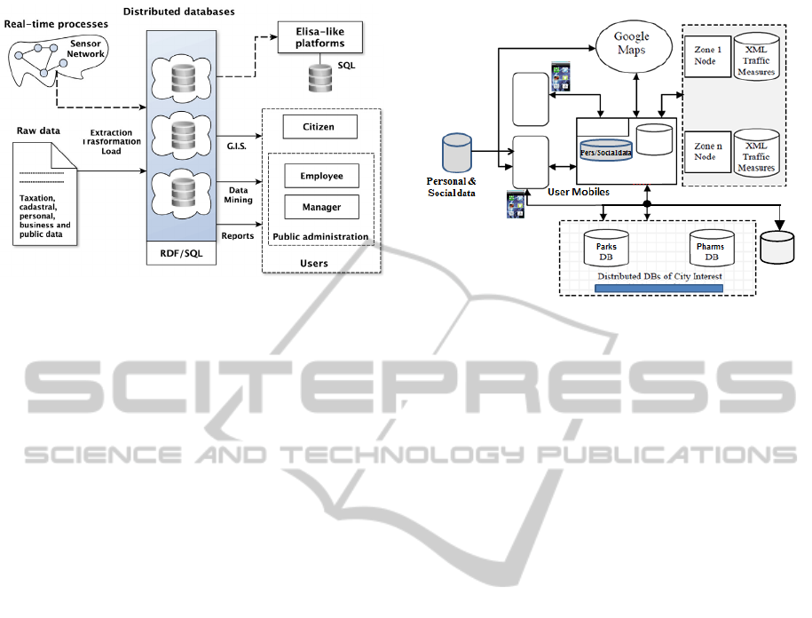
Figure 1: K-Metropolis: functional architecture.
are built by using distributed queries issued in a user
friendly format by a fixed or mobile device. Such
queries are converted into a language, i.e.,
SPARQL 1.1 (Prud’hommeaux and Seaborne,
2008), suitable to extract responses from the triple
stores of the Cloud.
To guarantee a smooth transition from the
current relational archives widely used by the Public
Administration to the envisaged semantic triple
stores, the proposed architecture supports also
queries expressed by distributed SQL formulas so
that it is possible to retrieve data from either SQL
tables or RDF archives.
This choice will allow us to query existing SQL-
based centralized DWH, e.g., as adopted in the
project ELISA promoted by the Italian Ministry for
the Regional Affairs described in http://www.tributi.
eng.it/blog/progetto-elisa/, or to query RDF triple
stores extracted from SQL tables in case the data
owners have defined the controlled vocabulary and
related RDF formats to give semantics to their data.
These ideas have inspired the implementation
architecture of the K-Metropolis project illustrated
in fig.2, where we point out the central XML DB
containing the data taken by a distributed real time
monitoring system dealing with urban transport
infrastructures, e.g., traffic and car pollution, or city
utilities such as electricity, water, gas. Also, XML
and SQL data stores belonging to organizations
offering public services (e.g., parks and pharms) and
Municipal DBs are taken into account to better
support walking and driving citizens.
In particular, fig.2 points out that K-Metropolis
is centered on a Ruby on Rails (RoR) server since
this software environment allows us to implement
the information system per use cases using the
Model-View-Controller paradigm (Hartl, 2011).
The
server is provided with a Decision Support
Figure 2: K-Metropolis implementation architecture.
System (DSS) illustrated in previous works, e.g.,
(Costanzo et al., 2013), to take advantage from all
the urban databases. If the server may enter into the
nodes of the monitoring system, then the DSS may
provide suggestions useful to control specific parts
of the urban infrastructures, e.g. (Aoun, 2013); if the
server may access only the general information
stored on the company servers devoted to manage
the single infrastructure or utility, then the DSS will
provide suggestions to improve daily maintenance,
optimizing the overall costs and planning future
expansions, e.g., (Al-Hader et al., 2009
).
In both the above cases, the K-Metropolis choice
of using XML protocols to exchange data with the
distant computing systems facilitates the required
DB interoperability, as clarified in sect.2.
The relevant points of interest and possibly the
best paths to reach them are sent to the mobile users
by means of JQMobile scripts (David, 2011) so that
they may be displayed on a Google Maps based user
interface of any mobile.
Moreover, a software based on the Flash Builder
framework (Corlan, 2009) has been developed to
implement the main DSS functionalities on the most
powerful mobiles, e.g., android or iphone devices.
This allows these mobiles to play an autonomous
powerful role in the ubiquitous information system.
Indeed, in this case, the mobiles may carry out e-
government operations without the intervention of
the server by means of their local DSS which takes
into account the personal data stored on the mobiles,
instead of the ones resident on the server, and the
required business data resident on the remote data
bases accessed directly through the GPRS network.
K-METROLIS
INFORMATION SYSTEM
Municipal
DBs
Real Time
Monitoring System
DSS
Flash
Builder
Mobile
DSS
JQ
Mobile
XML
DB
RoR Serve
r
ICEIS2013-15thInternationalConferenceonEnterpriseInformationSystems
324

3 DATA INTEGRATION
As known, the Ontology Web Language (OWL) is a
language for making ontological statements to be
used over the World Wide Web, and all its elements
(classes, properties and individuals) are defined as
RDF resources (Smith et al., 2004).
Unlike traditional systems that operate with a
scoped (or closed) vision of the reality that implies
that a not known statement is automatically false,
OWL makes an open world assumption considering
the unknown information as not explicitly false.
One of the main attractive feature of OWL is that
it allows us to integrate disparate data stores at the
only condition of describing the original data by
OWL statements belonging to a shared
representation of the concepts underlying these data.
Of course, ontologies have an effective utility
depending on if they are agreed by the cooperating
organizations and communities. For this reason, the
activity carried out by the Linked Data group at the
W3C and the Government Linked Data (GLD) that
are publishing data sets and knowledge bases for
supporting e-business and e-government activities
involving different organizations working at global
scale (Bizer et al., 2009) are very important. Such
ontologies may be refined by adding concepts able
to integrate the databases of companies and the ones
of the public departments that operate at local scale.
Although we have not yet well established global
and local ontologies defining e-government and e-
business activities, the mentioned semantic approach
remains the main methodology for the integration of
public data. For this reason, in K-Metropolis we
chosen to integrate the distributed data bases by
transforming the original SQL data into XML
statements to be easily mapped on their turn into the
standard RDF triples, once they will be available,
without changing the codification of the SQL data
stored at the lower layers.
For example, in K-Metropolis the XML
description of the parks of a city that can be
accessed by either the RoR server and the Flash
Builder based applications is as follows:
<parks>
<park>
<organization> … </organization>
<name> … </name>
<id> … </id>
<address> … </address>
<closing day> … </closing day>
<vacancy> … </vacancy>
<lng> … <lng>
<lat> … <lat>
</park>
</parks>
The only condition to allow the mobiles to retrieve
all the parks is that the RoR server is provided with a
XML directory service that contains the web of the
addresses of the various organizations that offer
parking services, i.e.:
<park directory>
<organization>
<URL> … </URL>
<id> … </id>
</organization>
</park directory >
Analogous XML descriptions have been defined to
represent the data of the other urban/metropolitan
Public Services. In this way, we may send to the
mobile users all the points of interest (POIs) and
provide the needed services independently on the
organization to which they belong to.
Fig.3 shows the main functionalities offered
currently to the citizens to help their mobility (i.e., to
find nearest convenient “parks” and “fuel stations”),
to assist the search of essential services (i.e.,
“pharms” and in a near future “hospitals”, and “first
aid centres”) and to support typical e-government
operations using the icon “offices”.
Figure 3: Some e-service and e-government functions
offered to the mobile users.
Such functionalities make use of the data
integration technology to offer effective services to
the users, e.g., fig.4 shows how the list of the parks
of different organizations is displayed on the user
IntegratingDistributedDataBasesinaSemanticFramework-TheK-MetropolisProject
325
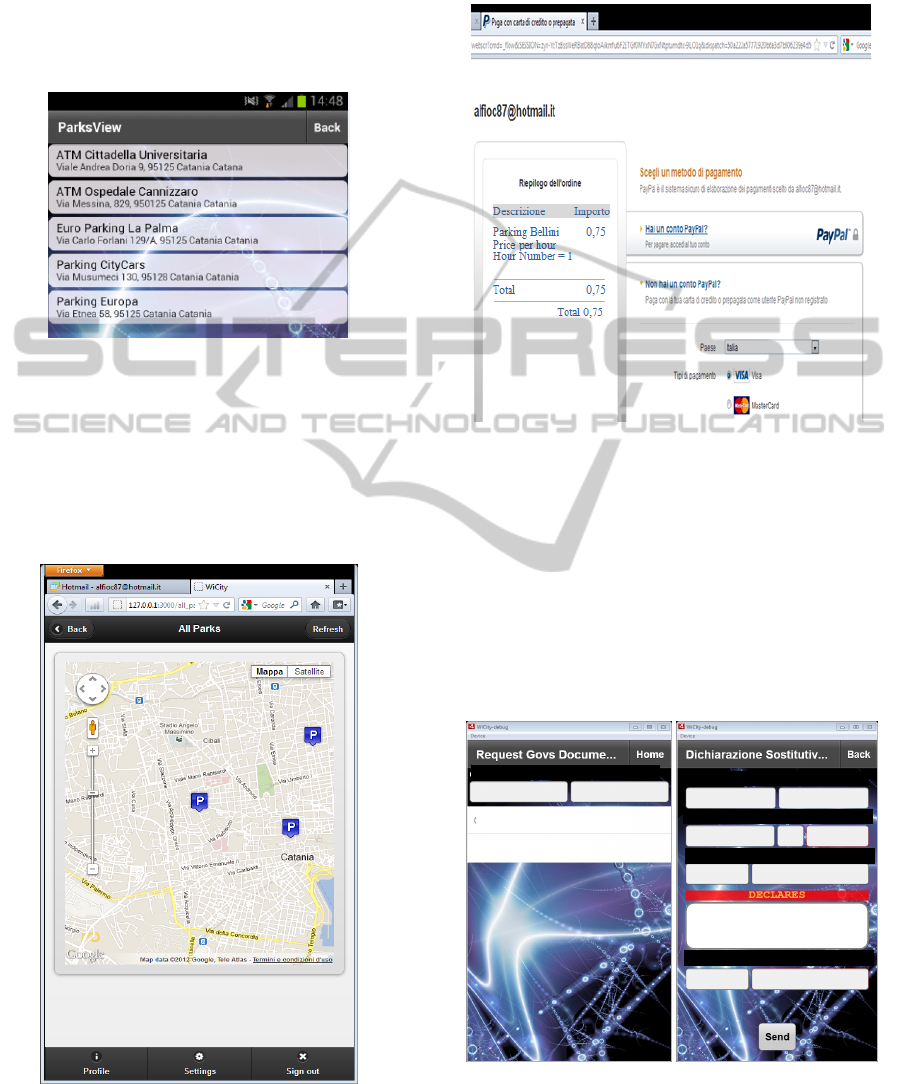
mobiles after the Flash Builder based application
resident on the mobile has extracted the data
relevant for the user query from different distant
servers using the described XML approach without
any server intervention. Similar information may be
obtained for the fuel stations, the pharms and the
other mentioned essential services.
Figure 4: Parking list meeting the user query. The parks
belong to different organizations.
After having extracted the services required by
the user, the DSS resident on the RoR server or on
the mobile is able to suggest: a) the most suitable
services, b) where they are located on Google Maps,
as illustrated in fig.5, and c) the best path to reach
them, as shown in (Costanzo et al., 2013).
Figure 5: Parking localization displayed on a Google Maps
based representation.
Also, K-Metropolis allows the users to pay in
advance all the mentioned services using PayPal
(fig.6).
Figure 6: e-Payment using PayPal for parking the car in
the park chosen by the user.
Let us note that not only e-commerce activities
but also e-government requests coming from the
citizen mobiles are supported by K-Metropolis, e.g.,
if we press the icon associated to the offices of the
Public Administration in fig.3, the mobile user may
ask certificates (fig.7.left) or may be supported in
compiling an affidavit (fig.7.right). This has been
obtained by transforming the municipal data from
relational tables to XML representations.
Figure 7: e-Certificates, on the left, and e-declaration, on
the right, required from the mobile either directly or
through the K-Metropolis server.
CertificateofResidence
BirthCertificate
Name Surname
Born at Born on
Fiscal_Code
Password
eMail:UserName-Provide
r
Residence:Cit
y
-Address
RossiPippo
CataniaIT3‐1‐90
CataniaviaEtnea8,95100
prossigmail.it
(c)
ICEIS2013-15thInternationalConferenceonEnterpriseInformationSystems
326

4 CONCLUSIONS
In the paper we have sketched the project named K-
Metropolis aiming at integrating disparate urban
data bases to support user mobility and to provide e-
commerce and e-government services to desktop
PCs and mobiles.
Although the proposed data integration has been
carried out by filtering a list of XML records
collected from distant sites using simple select-
where like operations, this simple data integration
method is powerful enough to cover many relevant
use cases required by citizens and companies.
Since join operations between distributed data
bases may be useful too, the mentioned companion
paper, i.e., (Giordano et al., 2013), illustrates how K-
Metropolis is able to accomplish this complex task,
as well as it presents how the use of a powerful GIS
may be used to display not only geo-referenced data
of the points of interest but also maps that further
qualify the land use for urban studies or to design
suitable interventions to improve civil protection.
In particular, in this companion paper we show
how using RDF data representations instead of the
XML schemes may improve data integration and
illustrate the SPARQL queries that are able to access
distributed RDF triple stores to carry out both select
and join operations.
Let us note that many approaches have been
proposed to offer information services to mobile
users. The dedicated navigators installed on the cars,
e.g., Garmin and Tom-Tom, were the first examples
of this technology. They may be easily used by the
drivers, but provide only transport information that
don’t take into account very often the real time car
traffic flows.
Although some protocols have been proposed to
improve the real time functionalities of such
navigators, e.g., VANET described in (Offor, 2012),
the car navigators remain with a limited area of
application. In particular, they cannot be used easily
to support walking people mobility, neither can be
used to carry out e-commerce and e-government
tasks.
For this reason, different location based
information systems were proposed in the last years.
They are mainly resident on mobiles and appear to
be a new generation of location based services
(LBSs) that help better people mobility as well as
facilitate e-commerce and e-government operations,
as foreseen in (TRG, 2008).
However, all the proposed LBSs of this second
generation are mainly proprietary systems, so they
miss two basic requirements of the modern LBSs
that are at the basis of the K-Metropolis project, i.e.,
the requirements that the urban data bases should be
open and interoperable, as claimed in (Teller et al.,
2010).
Therefore, our future work will be mainly the
one to study carefully the available urban ontology,
e.g., (Teller et al., 2007; Berdier and Roussey,
2007), to choose the ones that favour the
implementation of an urban presentation layer based
on an standard vocabulary that allows the above
mentioned K-Metropolis applications, resident on
either the server or the mobiles, to access all the
public data available at citywide scale thus
supporting the activity of the mobile users as
completely and flexible as possible.
REFERENCES
Al-Hader, M., et al., SOA of smart city geospatial
management. Third UKSim European Symposium on
Computer Modeling and Simulation, EMS '09, 2009.
Aoun C., The Smart City Cornerstone: Urban Efficiency.
Schneider Electric White Paper, 2013.
Berdier C., Roussey C., Urban Ontologies: the
Towntology Prototype towards Case Studies. Springer,
2007.
Bizer C., Heath T., Berners-Lee T., 2009. Linked data -
the story so far”, Int. J. Semantic Web Inf. Syst.,
vol.5(3).
Corlan M., Flash Platform Tooling: Flash Builder. Adobe,
2009.
Costanzo A., Faro A., Giordano D., Venticinque M., Wi-
City: A federated architecture of metropolitan
databases to support mobile users in real time. Int.
Conf. on Computer and Information Science, ICCIS. A
Conf. of World Engineering Science and Technology
Congress, ESTCON, 2012.
Costanzo A., Faro A., Giordano D., WI-CITY: living,
deciding and planning using mobiles in Intelligent
Cities. 3
rd
International Conference on Pervasive and
Embedded Computing and Communication Systems,
PECCS 2013, Barcelona, INSTICC, 2013.
Crisafi A., Giordano D., Spampinato C., GRIPLAB 1.0:
Grid Image Processing Laboratory for Distributed
Machine Vision Applications. Proc. 17th IEEE Int
Conf on Enabling Technologies: Infrastructure for
Collaborative Enterprises, WETICE ’08, IEEE, 2008.
David M., Developing Websites with jQuery Mobile.
Focal Press, 2011.
Faro A., Giordano D., Musarra A., Ontology Based
Mobility Information Systems. Proc. of Systems, Men
and Cybernetics Conference, SMC’03, vol.3, 4288-
4293, IEEE, 2003.
Faro A., Giordano D., Spampinato C., Evaluation of the
Traffic Parameters in a Metropolitan Area by Fusing
Visual Perceptions and CNN Processing of Webcam
IntegratingDistributedDataBasesinaSemanticFramework-TheK-MetropolisProject
327

Images. IEEE Transactions on Neural Networks, Vol.
19 (6), IEEE, 2008.
Faro A., Giordano D., Spampinato C., Integrating
Location Tracking, Traffic Monitoring and Semantics
in a Layered ITS Architecture. Intelligent Transport
Systems, vol.5(3),IET, 2011.
Faro A., Giordano D., Spampinato C., 2011. Adaptive
background modelling integrated with luminosity
sensors and occlusion processing for reliable vehicle
detection”, IEEE Transactions on Intelligent
Transportation Systems, Vol.12(4).
Giordano D., Torre A., Salemi C., Alessi S., Faro A., An
Ontology based Approach to Integrate Data and Maps
in the Government Enterprise Architecture: a Case
Study. Proc. 15th International Conference on
Enterprise Information Systems, ICEIS, Angers,
INSTICC, 2013.
Hartl M., 2011. Ruby on Rails 3. Addison Wesley.
Hayes. P., 2004. RDF Semantics. W3C Recommendation
10. http://www.w3.org/TR/rdf-mt.
Nebot. V., Berlanga. R., 2012. Building data warehouses
with semantic data. Decision Support Systems,
Vol.52(4). http://sparql-wrapper.sourceforge.net/.
Offor, P.I., Vehicle Ad Hoc Network (VANET). 2012.
Safety Benefits and Security Challenges. Available at
SSRN: http://ssrn.com/abstract=2206077.
Prud’hommeaux E., Seaborne A., 2008. SPARQL Query
Language for RDF. W3C Rec. 15.1.2. http://www.w3.
org/TR/rdf-sparql-query/.
Saha P., 2010. Government Enterprise Architecture
Research Project, NUS Institute of Systems Science.
http:// unpan1.un.org/intradoc/groups/public/
documents/unpan/unpan039390.pdf.
Salampasis, M., Tektonidis, D., Kalogianni, E.,
TraceALL: A Semantic Web Framework for Food
Traceability Systems. Jornal of Systems and
Information Technology, Vol. 14(4), 2005.
Sheth, A., Enterprise applications of semantic web, IFIP
International Conference on Industrial Applications of
Semantic Web. IASW2005, Finland, 2005.
Smith, M. K. , Welty, C.D., McGuinness D.L., OWL Web
Ontology Language Guide, W3C Recommendation.
http:// www. w3.org /TR/ 2004/REC-owl-guide-
20040210, 2004.
Telematics Reserach Group (TRG), Preview portable
navigation: the future is bright for connectivity.
http://www. telematicsresearch.com/PDFs/TRG_Press
_Jan_08.pdf,2008.
Teller J., John R. Lee J.R., Catherine Roussey C., (Eds.),
Ontologies for Urban Development, Springer, 2007.
Teller J., Billen R., Cutting-Decelle A.F., 2010. Ontology
based approaches for improving the interoperability
between 3D urban models. Journal of Inf. Technology
in Construction.
Zhai, J., Jiang, J., Yu, Y., Li J., Ontology-based
Integrated Information Platform for Digital City.
IEEE Proc. of Wireless Communications, Networking
and Mobile Comp., WiCOM ’08, 2008.
ICEIS2013-15thInternationalConferenceonEnterpriseInformationSystems
328
